
Chesil Beach
Encyclopedia
Dorset
Dorset , is a county in South West England on the English Channel coast. The county town is Dorchester which is situated in the south. The Hampshire towns of Bournemouth and Christchurch joined the county with the reorganisation of local government in 1974...
, southern England
England
England is a country that is part of the United Kingdom. It shares land borders with Scotland to the north and Wales to the west; the Irish Sea is to the north west, the Celtic Sea to the south west, with the North Sea to the east and the English Channel to the south separating it from continental...
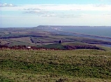
is one of three major shingle structures
Shingle beach
A shingle beach is a beach which is armoured with pebbles or small- to medium-sized cobbles. Typically, the stone composition may grade from characteristic sizes ranging from two to 200 mm diameter....
in Britain. Its toponym
Toponymy
Toponymy is the scientific study of place names , their origins, meanings, use and typology. The word "toponymy" is derived from the Greek words tópos and ónoma . Toponymy is itself a branch of onomastics, the study of names of all kinds...
is derived from the Old English ceosel or cisel, meaning "gravel" or "shingle".
The beach is often identified as a tombolo
Tombolo
A tombolo, from the Italian tombolo, derived from the Latin tumulus, meaning 'mound,' and sometimes translated as ayre , is a deposition landform in which an island is attached to the mainland by a narrow piece of land such as a spit or bar. Once attached, the island is then known as a tied island...
, although research into the geomorphology of the area has revealed that it is in fact a barrier beach
Shoal
Shoal, shoals or shoaling may mean:* Shoal, a sandbank or reef creating shallow water, especially where it forms a hazard to shipping* Shoal draught , of a boat with shallow draught which can pass over some shoals: see Draft...
which has "rolled" landwards, joining the mainland with Portland Bill
Portland Bill
Portland Bill is a narrow promontory of Portland stone, which forms the most southerly part of Isle of Portland, and therefore also the county of Dorset, England....
, giving the appearance of a tombolo. The shingle beach
Beach
A beach is a geological landform along the shoreline of an ocean, sea, lake or river. It usually consists of loose particles which are often composed of rock, such as sand, gravel, shingle, pebbles or cobblestones...
is 29 kilometres (18 mi) long, 200 metres (656.2 ft) wide and 15 metres (49.2 ft) high. The beach and the Fleet are part of the Jurassic Coast
Jurassic Coast
The Jurassic Coast is a World Heritage Site on the English Channel coast of southern England. The site stretches from Orcombe Point near Exmouth in East Devon to Old Harry Rocks near Swanage in East Dorset, a distance of ....
, a UNESCO
UNESCO
The United Nations Educational, Scientific and Cultural Organization is a specialized agency of the United Nations...
World Heritage Site
World Heritage Site
A UNESCO World Heritage Site is a place that is listed by the UNESCO as of special cultural or physical significance...
, and the location for a book, On Chesil Beach
On Chesil Beach
On Chesil Beach is a 2007 novel by the Booker Prize-winning British writer Ian McEwan. The novel was selected for the 2007 Booker Prize shortlist....
by Ian McEwan
Ian McEwan
Ian Russell McEwan CBE, FRSA, FRSL is a British novelist and screenwriter, and one of Britain's most highly regarded writers. In 2008, The Times named him among their list of "The 50 greatest British writers since 1945"....
.
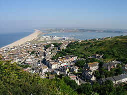
At the eastern end of the beach at the village of Chiswell, against the cliffs of the Isle of Portland
Isle of Portland
The Isle of Portland is a limestone tied island, long by wide, in the English Channel. Portland is south of the resort of Weymouth, forming the southernmost point of the county of Dorset, England. A tombolo over which runs the A354 road connects it to Chesil Beach and the mainland. Portland and...
, the beach curves round sharply to form Chesil Cove
Chesil Cove
Chesil Cove is a beach which is the most southerly part of the long Chesil Beach in Dorset, England.The beach protects the low lying village of Chiswell in Underhill on the Isle of Portland from flooding.-Diving:...
. This part of the beach protects the low-lying village from flooding. Westwards the shingle forms a straight line along the coast, enclosing the Fleet, a shallow tidal lagoon
Lagoon
A lagoon is a body of shallow sea water or brackish water separated from the sea by some form of barrier. The EU's habitat directive defines lagoons as "expanses of shallow coastal salt water, of varying salinity or water volume, wholly or partially separated from the sea by sand banks or shingle,...
.
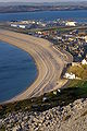
The beach provides shelter from the prevailing winds
Prevailing winds
Prevailing winds are winds that blow predominantly from a single general direction over a particular point on Earth's surface. The dominant winds are the trends in direction of wind with the highest speed over a particular point on the Earth's surface. A region's prevailing and dominant winds...
and wave
Wave
In physics, a wave is a disturbance that travels through space and time, accompanied by the transfer of energy.Waves travel and the wave motion transfers energy from one point to another, often with no permanent displacement of the particles of the medium—that is, with little or no associated mass...
s for the town of Weymouth and the village of Chiswell, which would otherwise probably not exist
Varying with the Bank's unbroken increase in height, to 14.7 metres (48.2 ft), above mean high water, the size of the flint
Flint
Flint is a hard, sedimentary cryptocrystalline form of the mineral quartz, categorized as a variety of chert. It occurs chiefly as nodules and masses in sedimentary rocks, such as chalks and limestones. Inside the nodule, flint is usually dark grey, black, green, white, or brown in colour, and...
and chert
Chert
Chert is a fine-grained silica-rich microcrystalline, cryptocrystalline or microfibrous sedimentary rock that may contain small fossils. It varies greatly in color , but most often manifests as gray, brown, grayish brown and light green to rusty red; its color is an expression of trace elements...
shingle varies from pea-sized at the north-west end (by West Bay) to orange-sized at the south-east end (by Portland). It is said that smugglers who landed on the beach in the middle of the night could judge "exactly where they were" by the size of the shingle.
The Fleet Lagoon
From West Bay to Cliff End the beach is piled up against the cliff. At Cliff End a hollow forms behind the beach and at Abbotsbury a stretch of salineSalinity
Salinity is the saltiness or dissolved salt content of a body of water. It is a general term used to describe the levels of different salts such as sodium chloride, magnesium and calcium sulfates, and bicarbonates...
(or brackish) water called the Fleet Lagoon
Lagoon
A lagoon is a body of shallow sea water or brackish water separated from the sea by some form of barrier. The EU's habitat directive defines lagoons as "expanses of shallow coastal salt water, of varying salinity or water volume, wholly or partially separated from the sea by sand banks or shingle,...
begins. The Fleet is home to many wading birds and Abbotsbury Swannery
Abbotsbury Swannery
Abbotsbury Swannery is the only managed colony of nesting mute swans in the world. It is situated near the village of Abbotsbury in Dorset, England, west of Weymouth on a site around the Fleet lagoon protected from the weather of Lyme Bay by Chesil Beach. The colony can number over 600 swans with...
, and fossil
Fossil
Fossils are the preserved remains or traces of animals , plants, and other organisms from the remote past...
s can be found in the sand and mud.
Both Chesil Beach and the Fleet Lagoon are a Site of Special Scientific Interest
Site of Special Scientific Interest
A Site of Special Scientific Interest is a conservation designation denoting a protected area in the United Kingdom. SSSIs are the basic building block of site-based nature conservation legislation and most other legal nature/geological conservation designations in Great Britain are based upon...
, and the view of the beach from Abbotsbury has been voted by Country Life
Country Life (magazine)
Country Life is a British weekly magazine, based in London at 110 Southwark Street, and owned by IPC Media, a Time Warner subsidiary.- Topics :The magazine covers the pleasures and joys of rural life, as well as the concerns of rural people...
magazine as Britain's third best view. The Fleet Lagoon and Chesil Beach feature in the novel Moonfleet
Moonfleet
Moonfleet is a tale of smuggling by the English novelist J. Meade Falkner, first published in 1898. The book was extremely popular among children worldwide up until the 1970s, mostly for its themes of adventure and gripping storyline...
by J. Meade Falkner
J. Meade Falkner
John Meade Falkner was an English novelist and poet, best known for his 1898 novel, Moonfleet. An extremely successful businessman as well, he became chairman of the arms manufacturer Armstrong Whitworth during World War I.-Life and works:Falkner was born in Manningford Bruce, Wiltshire and spent...
(1898), in which the village of Moonfleet is based on the real village of East Fleet.
Origin
The origin of Chesil Beach has been argued over for some time. Originally it was believed that beach material was from the Budleigh SaltertonBudleigh Salterton
Budleigh Salterton is a small town on the south coast of Devon, England 15 miles south of Exeter. It is situated within an Area of Outstanding Natural Beauty designated East Devon AONB.- Features :...
pebble beds to the west and later from Portland to the south east. The differences between the pebbles on the beach and nearby sources is now put down to the Flandrian
Flandrian interglacial
The Flandrian interglacial or stage is the name given by geologists and archaeologists in the British Isles to the first, and so far only, stage of the Holocene epoch , covering the period from around 12,000 years ago, at the end of the last glacial period to the present day. As such, it is in...
isostatic
Isostasy
Isostasy is a term used in geology to refer to the state of gravitational equilibrium between the earth's lithosphere and asthenosphere such that the tectonic plates "float" at an elevation which depends on their thickness and density. This concept is invoked to explain how different topographic...
sea level rise
Current sea level rise
Current sea level rise potentially impacts human populations and the wider natural environment . Global average sea level rose at an average rate of around 1.8 mm per year over 1961 to 2003 and at an average rate of about 3.1 mm per year from 1993 to 2003...
, so the feature could also be considered a barrier beach or bar
Shoal
Shoal, shoals or shoaling may mean:* Shoal, a sandbank or reef creating shallow water, especially where it forms a hazard to shipping* Shoal draught , of a boat with shallow draught which can pass over some shoals: see Draft...
, that happens to connect the mainland to an island rather than a 'true' tombolo
Tombolo
A tombolo, from the Italian tombolo, derived from the Latin tumulus, meaning 'mound,' and sometimes translated as ayre , is a deposition landform in which an island is attached to the mainland by a narrow piece of land such as a spit or bar. Once attached, the island is then known as a tied island...
. Normally, tombolos are created due to the effects of the island on waves (through refraction
Refraction
Refraction is the change in direction of a wave due to a change in its speed. It is essentially a surface phenomenon . The phenomenon is mainly in governance to the law of conservation of energy. The proper explanation would be that due to change of medium, the phase velocity of the wave is changed...
) and to sediment transport
Sediment transport
Sediment transport is the movement of solid particles , typically due to a combination of the force of gravity acting on the sediment, and/or the movement of the fluid in which the sediment is entrained...
, which usually produces a beach perpendicular to the mainland rather than parallel to it.
World War Two defences
Because of the low population density of nearby areas and their proximity to the naval base on Portland, the beach and the Fleet were used for machine gunMachine gun
A machine gun is a fully automatic mounted or portable firearm, usually designed to fire rounds in quick succession from an ammunition belt or large-capacity magazine, typically at a rate of several hundred rounds per minute....
training and bouncing bomb
Bouncing bomb
A bouncing bomb is a bomb designed specifically to bounce to a target across water in a calculated manner, in order to avoid obstacles such as torpedo nets, and to allow both the bomb's speed on arrival at the target and the timing of its detonation to be pre-determined...
testing for Operation Chastise
Operation Chastise
Operation Chastise was an attack on German dams carried out on 16–17 May 1943 by Royal Air Force No. 617 Squadron, subsequently known as the "Dambusters", using a specially developed "bouncing bomb" invented and developed by Barnes Wallis...
in World War II
World War II
World War II, or the Second World War , was a global conflict lasting from 1939 to 1945, involving most of the world's nations—including all of the great powers—eventually forming two opposing military alliances: the Allies and the Axis...
.
The World War Two defences
British anti-invasion preparations of World War II
British anti-invasion preparations of the Second World War entailed a large-scale division of military and civilian mobilisation in response to the threat of invasion by German armed forces in 1940 and 1941. The British army needed to recover from the defeat of the British Expeditionary Force in...
constructed on and around Chesil Beach have been documented. A double row of anti-tank blocks divides the beach near Abbotsbury. The portion of the beach to the east of this division, in front of Fleet Lagoon, had no passive defences against a landing, whereas the beach to the west was protected with miles of Admiralty scaffolding
Admiralty scaffolding
Admiralty scaffolding, also known as Obstacle Z.1 or sometimes simply given as beach scaffolding or anti-tank scaffolding, was a British design of anti-tank and anti-boat obstacle made of tubular steel. It was widely deployed on beaches of southern England, eastern England and the south western...
with anti-tank ditches and minefields and flame fougasse
Flame fougasse
A flame fougasse is a weapon. It is a type of mine which uses an explosive charge to project burning liquid onto a target. The flame fougasse was developed by the Petroleum Warfare Department in Britain as an anti-tank weapon during the invasion crisis of 1940...
installations a little further inland. There were many pillboxes
British hardened field defences of World War II
British hardened field defences of World War II were small fortified structures constructed as a part of British anti-invasion preparations. They were popularly known as pillboxes by reference to their shape.-Design and development:...
.
See also
The Jurassic CoastJurassic Coast
The Jurassic Coast is a World Heritage Site on the English Channel coast of southern England. The site stretches from Orcombe Point near Exmouth in East Devon to Old Harry Rocks near Swanage in East Dorset, a distance of ....
stretches over a distance of 153 kilometres (95 mi),
from Orcombe Point
Orcombe Point
Orcombe Point is a coastal feature near Exmouth, Devon, on the south coast of England. It lies about south of the city of Exeter, southeast of Exmouth town centre and about southwest of Sidmouth....
near Exmouth
Exmouth, Devon
Exmouth is a port town, civil parish and seaside resort in East Devon, England, sited on the east bank of the mouth of the River Exe. In 2001, it had a population of 32,972.-History:...
, in the west, to Old Harry Rocks
Old Harry Rocks
The Old Harry Rocks are two chalk sea stacks located at Handfast Point, on the Isle of Purbeck in Dorset, southern England.- Location :Old Harry Rocks lie directly east of Studland, about 4 kilometres northeast of Swanage, and about 10 kilometres south of the large towns of Poole and...
on the Isle of Purbeck
Isle of Purbeck
The Isle of Purbeck, not a true island but a peninsula, is in the county of Dorset, England. It is bordered by the English Channel to the south and east, where steep cliffs fall to the sea; and by the marshy lands of the River Frome and Poole Harbour to the north. Its western boundary is less well...
, in the east. The coastal exposures along the coastline provide a continuous sequence of Triassic
Triassic
The Triassic is a geologic period and system that extends from about 250 to 200 Mya . As the first period of the Mesozoic Era, the Triassic follows the Permian and is followed by the Jurassic. Both the start and end of the Triassic are marked by major extinction events...
, Jurassic
Jurassic
The Jurassic is a geologic period and system that extends from about Mya to Mya, that is, from the end of the Triassic to the beginning of the Cretaceous. The Jurassic constitutes the middle period of the Mesozoic era, also known as the age of reptiles. The start of the period is marked by...
and Cretaceous
Cretaceous
The Cretaceous , derived from the Latin "creta" , usually abbreviated K for its German translation Kreide , is a geologic period and system from circa to million years ago. In the geologic timescale, the Cretaceous follows the Jurassic period and is followed by the Paleogene period of the...
rock formations spanning approximately 185 million years of the Earths history. The localities along the Jurassic Coast includes a large range of important fossil
Fossil
Fossils are the preserved remains or traces of animals , plants, and other organisms from the remote past...
zones.
- List of places on the Jurassic Coast
- List of Dorset beaches
- Jurassic CoastJurassic CoastThe Jurassic Coast is a World Heritage Site on the English Channel coast of southern England. The site stretches from Orcombe Point near Exmouth in East Devon to Old Harry Rocks near Swanage in East Dorset, a distance of ....