
.gif)
Stack (geology)
Encyclopedia
A stack is a geological
landform
consisting of a steep and often vertical column or columns of rock in the sea near a coast, isolated by erosion. Stacks are formed through processes of coastal geomorphology, which are entirely natural. Time, wind and water are the only factors involved in the formation of a stack. They are formed when part of a headland
is eroded
by hydraulic action
, which is the force of the sea or water crashing against the rock. The force of the water weakens cracks in the headland, causing them to later collapse, forming free-standing stacks and even a small island. Without the constant presence of water, stacks also form when a natural arch
collapses under gravity, due to sub-aerial processes like wind erosion. Stacks can provide important nesting locations for seabird
s, and many are popular for rock climbing
.
cliffs. These rock types' medium hardness means medium resistance to erosion
. A more resistant layer may form a capstone
. Cliffs with weaker rock such as clay
tend to slump and erode too quickly to form stacks, while harder rocks such as granite
erode in different ways.
The formation process usually begins when the sea attacks small cracks in a headland and opens them. The cracks then gradually get larger and turn into a small cave. When the cave wears through the headland, an arch forms. Further erosion causes the arch to collapse, leaving the pillar of hard rock standing away from the coast - the stack. Eventually, erosion will cause the stack to collapse, leaving a stump. This stump is usually a small rock island, small enough to be submerged by high tide.
and Pacific ocean
s, in the Russian Far East
, and for stone columns in the watersheds of the Lena
, Yana
and Indigirka River
s.
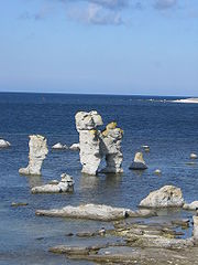
The Swedish rauk refers to a stone column created by natural erosion. Examples are found on the islands of Gotland
, Fårö
and Öland
.
Geology
Geology is the science comprising the study of solid Earth, the rocks of which it is composed, and the processes by which it evolves. Geology gives insight into the history of the Earth, as it provides the primary evidence for plate tectonics, the evolutionary history of life, and past climates...
landform
Landform
A landform or physical feature in the earth sciences and geology sub-fields, comprises a geomorphological unit, and is largely defined by its surface form and location in the landscape, as part of the terrain, and as such, is typically an element of topography...
consisting of a steep and often vertical column or columns of rock in the sea near a coast, isolated by erosion. Stacks are formed through processes of coastal geomorphology, which are entirely natural. Time, wind and water are the only factors involved in the formation of a stack. They are formed when part of a headland
Headlands and bays
Headlands and bays are two related features of the coastal environment.- Geology and geography :Headlands and bays are often found on the same coastline. A bay is surrounded by land on three sides, whereas a headland is surrounded by water on three sides. Headlands are characterized by high,...
is eroded
Erosion
Erosion is when materials are removed from the surface and changed into something else. It only works by hydraulic actions and transport of solids in the natural environment, and leads to the deposition of these materials elsewhere...
by hydraulic action
Hydraulic action
Hydraulic action is strong enough to loosen sediment along the river bed and banks this will take rocks from the side of the banks and add it to the rivers loads. The water compresses the air in the crack, pushing it right to the back. As the wave retreats, the highly pressurized air is suddenly...
, which is the force of the sea or water crashing against the rock. The force of the water weakens cracks in the headland, causing them to later collapse, forming free-standing stacks and even a small island. Without the constant presence of water, stacks also form when a natural arch
Natural arch
A natural arch or natural bridge is a natural geological formation where a rock arch forms, with an opening underneath. Most natural arches form as a narrow ridge, walled by cliffs, become narrower from erosion, with a softer rock stratum under the cliff-forming stratum gradually eroding out until...
collapses under gravity, due to sub-aerial processes like wind erosion. Stacks can provide important nesting locations for seabird
Seabird
Seabirds are birds that have adapted to life within the marine environment. While seabirds vary greatly in lifestyle, behaviour and physiology, they often exhibit striking convergent evolution, as the same environmental problems and feeding niches have resulted in similar adaptations...
s, and many are popular for rock climbing
Rock climbing
Rock climbing also lightly called 'The Gravity Game', is a sport in which participants climb up, down or across natural rock formations or artificial rock walls. The goal is to reach the summit of a formation or the endpoint of a pre-defined route without falling...
.
Formation
Stacks typically form in horizontally bedded sedimentary or volcanic rocks particularly on limestoneLimestone
Limestone is a sedimentary rock composed largely of the minerals calcite and aragonite, which are different crystal forms of calcium carbonate . Many limestones are composed from skeletal fragments of marine organisms such as coral or foraminifera....
cliffs. These rock types' medium hardness means medium resistance to erosion
Erosion
Erosion is when materials are removed from the surface and changed into something else. It only works by hydraulic actions and transport of solids in the natural environment, and leads to the deposition of these materials elsewhere...
. A more resistant layer may form a capstone
Capstone
Capstone may refer to:* Coping , one of the finishing or protective stones that form the top of an exterior masonry wall or building* Capstone , a US government project about cryptographic standards...
. Cliffs with weaker rock such as clay
Clay
Clay is a general term including many combinations of one or more clay minerals with traces of metal oxides and organic matter. Geologic clay deposits are mostly composed of phyllosilicate minerals containing variable amounts of water trapped in the mineral structure.- Formation :Clay minerals...
tend to slump and erode too quickly to form stacks, while harder rocks such as granite
Granite
Granite is a common and widely occurring type of intrusive, felsic, igneous rock. Granite usually has a medium- to coarse-grained texture. Occasionally some individual crystals are larger than the groundmass, in which case the texture is known as porphyritic. A granitic rock with a porphyritic...
erode in different ways.
The formation process usually begins when the sea attacks small cracks in a headland and opens them. The cracks then gradually get larger and turn into a small cave. When the cave wears through the headland, an arch forms. Further erosion causes the arch to collapse, leaving the pillar of hard rock standing away from the coast - the stack. Eventually, erosion will cause the stack to collapse, leaving a stump. This stump is usually a small rock island, small enough to be submerged by high tide.
Other languages
The term kekur is used for the stacks in the ArcticArctic Ocean
The Arctic Ocean, located in the Northern Hemisphere and mostly in the Arctic north polar region, is the smallest and shallowest of the world's five major oceanic divisions...
and Pacific ocean
Pacific Ocean
The Pacific Ocean is the largest of the Earth's oceanic divisions. It extends from the Arctic in the north to the Southern Ocean in the south, bounded by Asia and Australia in the west, and the Americas in the east.At 165.2 million square kilometres in area, this largest division of the World...
s, in the Russian Far East
Russian Far East
Russian Far East is a term that refers to the Russian part of the Far East, i.e., extreme east parts of Russia, between Lake Baikal in Eastern Siberia and the Pacific Ocean...
, and for stone columns in the watersheds of the Lena
Lena River
The Lena is the easternmost of the three great Siberian rivers that flow into the Arctic Ocean . It is the 11th longest river in the world and has the 9th largest watershed...
, Yana
Yana River
The Yana River , is a river in Sakha in Russia, located between the Lena to the west and the Indigirka to the east.It is 872 km in length. The area of its basin is 238,000 km², whilst its annual discharge totals approximately . Most of this discharge occurs in May and June as the ice on the...
and Indigirka River
Indigirka River
The Indigirka River is a river in the Sakha Republic in Russia between the Yana River and the Kolyma River. It is in length. The area of its basin is 360,000 km²...
s.
The Swedish rauk refers to a stone column created by natural erosion. Examples are found on the islands of Gotland
Gotland
Gotland is a county, province, municipality and diocese of Sweden; it is Sweden's largest island and the largest island in the Baltic Sea. At 3,140 square kilometers in area, the region makes up less than one percent of Sweden's total land area...
, Fårö
Fårö
Fårö is a small Baltic Sea island north of the island of Gotland, off Sweden's southeastern coast. It is the second-largest island in the province. It has a population of fewer than 600 and has become a popular summer resort. The island has no banks, post offices, medical services or police...
and Öland
Öland
' is the second largest Swedish island and the smallest of the traditional provinces of Sweden. Öland has an area of 1,342 km² and is located in the Baltic Sea just off the coast of Småland. The island has 25,000 inhabitants, but during Swedish Midsummer it is visited by up to 500,000 people...
.
Examples
- FaraglioniFaraglioniFaraglioni is the collective name for three stacks located off the island of Capri in the Bay of Naples. The stacks have been given their own names: Stella , Mezzo , and Scopolo . Its height is 109 m, 82 m and 106 m, respectively. The lacerta viridens faraglionesis or the blue-tinted lizard can...
, CapriCapriCapri is an Italian island in the Tyrrhenian Sea off the Sorrentine Peninsula, on the south side of the Gulf of Naples, in the Campania region of Southern Italy...
, Italy - The Big Flowerpot, Flowerpot IslandFlowerpot IslandFlowerpot Island is an island in Georgian Bay, in the Canadian province of Ontario and is a part of Fathom Five National Marine Park. The island spans 2.1 km from east to west, and 1.5 km from north to south, and has a total area of 2 km²...
, Lake HuronLake HuronLake Huron is one of the five Great Lakes of North America. Hydrologically, it comprises the larger portion of Lake Michigan-Huron. It is bounded on the east by the Canadian province of Ontario and on the west by the state of Michigan in the United States...
, Canada. - Three Sisters, Eatonville, Nova ScotiaEatonville, Nova ScotiaEatonville is a former lumber and shipbuilding village in Cumberland County, Nova Scotia. It includes a large tidal harbour at the mouth of the Eatonville Brook beside several dramatic sea stacks known as the "Three Sisters". It was founded in 1864 and abandoned in the 1940s...
. - Goat RockGoat Rock BeachGoat Rock Beach is a sand beach in northwestern Sonoma County, California, United States.This landform is a sub-unit of Sonoma Coast State Beach, owned and managed by the State of California...
, CaliforniaCaliforniaCalifornia is a state located on the West Coast of the United States. It is by far the most populous U.S. state, and the third-largest by land area...
, USA. - Sugar LoafSugar Loaf (Mackinac Island)Sugar Loaf is a 75-foot-high landlocked rock or stack in the interior of Mackinac Island in Lake Huron. Created by erosion during the period of postglacial Lake Algonquin, Sugar Loaf is the largest post-glacial erosion feature in the Straits of Mackinac...
, Mackinac IslandMackinac IslandMackinac Island is an island and resort area covering in land area, part of the U.S. state of Michigan. It is located in Lake Huron, at the eastern end of the Straits of Mackinac, between the state's Upper and Lower Peninsulas. The island was home to a Native American settlement before European...
, MichiganMichiganMichigan is a U.S. state located in the Great Lakes Region of the United States of America. The name Michigan is the French form of the Ojibwa word mishigamaa, meaning "large water" or "large lake"....
, USA. - Haystack RockHaystack RockHaystack Rock is a 235-foot sea stack in Cannon Beach, Oregon. It is sometimes claimed locally to be the third-tallest such "intertidal" structure in the world, but there are no scientific references to support this. A popular tourist destination, the monolithic rock is adjacent to the beach and...
, Cannon Beach, OregonOregonOregon is a state in the Pacific Northwest region of the United States. It is located on the Pacific coast, with Washington to the north, California to the south, Nevada on the southeast and Idaho to the east. The Columbia and Snake rivers delineate much of Oregon's northern and eastern...
, USA. - Old Harry RocksOld Harry RocksThe Old Harry Rocks are two chalk sea stacks located at Handfast Point, on the Isle of Purbeck in Dorset, southern England.- Location :Old Harry Rocks lie directly east of Studland, about 4 kilometres northeast of Swanage, and about 10 kilometres south of the large towns of Poole and...
, DorsetDorsetDorset , is a county in South West England on the English Channel coast. The county town is Dorchester which is situated in the south. The Hampshire towns of Bournemouth and Christchurch joined the county with the reorganisation of local government in 1974...
, England. - The NeedlesThe NeedlesThe Needles is a row of three distinctive stacks of chalk that rise out of the sea off the western extremity of the Isle of Wight, England, close to Alum Bay. The Needles lighthouse stands at the end of the formation...
, Isle of WightIsle of WightThe Isle of Wight is a county and the largest island of England, located in the English Channel, on average about 2–4 miles off the south coast of the county of Hampshire, separated from the mainland by a strait called the Solent...
, England. - Am BuachailleAm BuachailleAm Buachaille is a sea stack, or vertical rock formation, near Sandwood Bay in the Scottish county of Sutherland at . It was first climbed in 1968 by the mountaineers Tom Patey and Ian Clough. The name means "The herdsman" in Scottish Gaelic.-External links:...
, SutherlandSutherlandSutherland is a registration county, lieutenancy area and historic administrative county of Scotland. It is now within the Highland local government area. In Gaelic the area is referred to according to its traditional areas: Dùthaich 'IcAoidh , Asainte , and Cataibh...
, ScotlandScotlandScotland is a country that is part of the United Kingdom. Occupying the northern third of the island of Great Britain, it shares a border with England to the south and is bounded by the North Sea to the east, the Atlantic Ocean to the north and west, and the North Channel and Irish Sea to the...
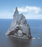
. - Ball's PyramidBall's PyramidBall's Pyramid is an erosional remnant of a shield volcano and caldera that formed about 7 million years ago. Ball's Pyramid is southeast of Lord Howe Island in the Pacific Ocean. It is high, while measuring only in length and across, making it the tallest volcanic stack in the world...
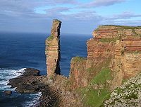
, Lord Howe Island Group, Australia - Old Man of HoyOld Man of HoyThe Old Man of Hoy is a sea stack of red sandstone perched on a plinth of igneous basalt rock, close to Rackwick Bay on the west coast of the island of Hoy, in the Orkney Islands, Scotland. It is a distinctive landmark seen from the Thurso to Stromness ferry, MV Hamnavoe, and is a famous rock climb...
, Orkney, ScotlandScotlandScotland is a country that is part of the United Kingdom. Occupying the northern third of the island of Great Britain, it shares a border with England to the south and is bounded by the North Sea to the east, the Atlantic Ocean to the north and west, and the North Channel and Irish Sea to the...
. - The Twelve Apostles, VictoriaThe Twelve Apostles, VictoriaThe Twelve Apostles is a collection of limestone stacks off the shore of the Port Campbell National Park, by the Great Ocean Road in Victoria, Australia...
on the Great Ocean RoadGreat Ocean RoadThe Great Ocean Road is a stretch of road along the south-eastern coast of Australia between the Victorian cities of Torquay and Warrnambool. The road was built by returned soldiers between 1919 and 1932, and is the world's largest war memorial; dedicated to casualties of World War I...
, Victoria, Australia - Percé RockPercé RockPercé Rock is a huge sheer rock formation in the Gulf of Saint Lawrence on the tip of the Gaspé Peninsula in Quebec, Canada, off Percé Bay. Percé Rock appears from a distance like a ship under sail. It is one of the world's largest natural arches located in water and is considered a natural icon...
, Percé, QuebecQuebecQuebec or is a province in east-central Canada. It is the only Canadian province with a predominantly French-speaking population and the only one whose sole official language is French at the provincial level....
, Canada - Baia dei Mergoli, MattinataMattinataMattinata is a famous seaside resort town and comune in the province of Foggia, Apulia, southern Italy.-Geography:The only town in Apulia facing south the Adriatic sea, Mattinata is part of the Gargano National Park . The main urban area is located above two hills enclosed by mountains in the...
, southern Italy - Hopewell RocksHopewell RocksThe Hopewell Rocks, also called the Flowerpot Rocks or simply The Rocks, are rock formations caused by tidal erosion in The Hopewell Rocks Ocean Tidal Exploration Site in New Brunswick....
, Hopewell CapeHopewell CapeHopewell Cape is a Canadian village and headland in Albert County, New Brunswick at the northern end of Shepody Bay and the mouth of the Petitcodiac River.Located 31 kilometres south of Moncton, Hopewell Cape is the former shire town of Albert County...
New BrunswickNew BrunswickNew Brunswick is one of Canada's three Maritime provinces and is the only province in the federation that is constitutionally bilingual . The provincial capital is Fredericton and Saint John is the most populous city. Greater Moncton is the largest Census Metropolitan Area...
, Canada - Po Pin Chau, High Island, Hong KongHigh Island, Hong KongHigh Island or Leung Shuen Wan is a former island in the southeast of Sai Kung Peninsula, Hong Kong. The island was connected to the peninsula by two dams to enclose the Kwun Mun Channel and form the High Island Reservoir. The construction of the dam spanned 10 years from 1969 to 1979...
- ÉtretatÉtretatÉtretat is a commune in the Seine-Maritime department in the Haute-Normandie region in northern France. It is a tourist and farming town situated c. 32 km northeast of Le Havre, at the junction of the D940, D11 and D139 roads. It's located on the coast of the Pays de Caux area.-The...
, Seine-MaritimeSeine-MaritimeSeine-Maritime is a French department in the Haute-Normandie region in northern France. It is situated on the northern coast of France, at the mouth of the Seine, and includes the cities of Rouen and Le Havre...
, France - Torre Sant'Andrea, southern Italy
- Acitrezza, Sicily, Italy
- Nebida and Masua, south-western SardiniaSardiniaSardinia is the second-largest island in the Mediterranean Sea . It is an autonomous region of Italy, and the nearest land masses are the French island of Corsica, the Italian Peninsula, Sicily, Tunisia and the Spanish Balearic Islands.The name Sardinia is from the pre-Roman noun *sard[],...
, Italy - Lange AnnaLange AnnaLange Anna , is a high sea stack of Buntsandstein in the North Sea island of Heligoland, Germany. Formerly it was also known as Hengst or Mönch, but its real local name is Nathurn Stak . Climbing the stack is not allowed but tourists can look at the rock from a distance.Lange Anna is somewhat...
on Heligoland - Stac an ArminStac an ArminStac an Armin , based on the proper Scottish Gaelic spelling , is a sea stack in the St Kilda archipelago. It is 196 metres tall, qualifying it as a Marilyn...
, St Kilda, ScotlandSt Kilda, ScotlandSt Kilda is an isolated archipelago west-northwest of North Uist in the North Atlantic Ocean. It contains the westernmost islands of the Outer Hebrides of Scotland. The largest island is Hirta, whose sea cliffs are the highest in the United Kingdom and three other islands , were also used for... - Stac Dhomnuill Chaim, Lewis, Scotland
- Isola del Giglio, Tuscany, Italy
- Tri BrataTri BrataTri Brata is a set of three rocks at the entrance to the Avacha Bay. This picturesque stack, or rather kekur, is considered a symbol of Petropavlovsk-Kamchatsky....
and Sail RockSail RockSail Rock, or Parus Rock , is a natural sandstone monolith located on the shore of the Black Sea, in Krasnodar Krai, Russia. It resembles the outline of a ship's sail, hence its name....
, Russia - Les Jumeaux, HendayeHendayeHendaye is the most south-westerly town and commune in France, lying in the Pyrénées-Atlantiques department and located in the traditional province Lapurdi of the French Basque Country...
, France - El Dedo de DiosEl Dedo de DiosEl Dedo de Dios was a famous rock structure in the Atlantic Ocean, located in the northern part of Gran Canaria, one of the Canary Islands...
, Canary IslandsCanary IslandsThe Canary Islands , also known as the Canaries , is a Spanish archipelago located just off the northwest coast of mainland Africa, 100 km west of the border between Morocco and the Western Sahara. The Canaries are a Spanish autonomous community and an outermost region of the European Union...
, Spain - Ko TapuKo TapuKhao Phing Kan or Ko Khao Phing Kan is a pair of islands on the west coast of Thailand, in the Phang Nga Bay, Andaman Sea. About from its shores lies a 20 meters tall islet Ko Tapu or Khao Tapu . The island is a part of the Ao Phang Nga National Park...
, Phang Nga BayPhang Nga BayPhang Nga Bay is a 400 km² bay in the Andaman Sea between the island of Phuket and the mainland of the Malay peninsula of southern Thailand. Since 1981, an extensive section of the bay has been protected as the Ao Phang Nga National Park...
, ThailandThailandThailand , officially the Kingdom of Thailand , formerly known as Siam , is a country located at the centre of the Indochina peninsula and Southeast Asia. It is bordered to the north by Burma and Laos, to the east by Laos and Cambodia, to the south by the Gulf of Thailand and Malaysia, and to the... - RockallRockallRockall is an extremely small, uninhabited, remote rocky islet in the North Atlantic Ocean. It gives its name to one of the sea areas named in the shipping forecast provided by the British Meteorological Office....
, North Atlantic