

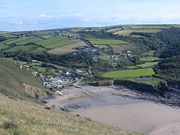
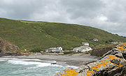
Crackington Haven
Encyclopedia

Cornwall
Cornwall is a unitary authority and ceremonial county of England, within the United Kingdom. It is bordered to the north and west by the Celtic Sea, to the south by the English Channel, and to the east by the county of Devon, over the River Tamar. Cornwall has a population of , and covers an area of...
, United Kingdom
United Kingdom
The United Kingdom of Great Britain and Northern IrelandIn the United Kingdom and Dependencies, other languages have been officially recognised as legitimate autochthonous languages under the European Charter for Regional or Minority Languages...
. It is located in the civil parish
Civil parish
In England, a civil parish is a territorial designation and, where they are found, the lowest tier of local government below districts and counties...
of St Gennys
St Gennys
St Gennys is a coastal civil parish and small settlement in north Cornwall, United Kingdom.The hamlet of St Gennys is situated approximately seven miles southwest of Bude. It is on high ground half-a-mile north of the coastal village of Crackington Haven, the major settlement in the parish...
at at the head of a cove on the Atlantic
Atlantic Ocean
The Atlantic Ocean is the second-largest of the world's oceanic divisions. With a total area of about , it covers approximately 20% of the Earth's surface and about 26% of its water surface area...
coast. The village is seven miles (11 km) south-southwest of Bude
Bude
Bude is a small seaside resort town in North Cornwall, England, at the mouth of the River Neet . It lies just south of Flexbury, north of Widemouth Bay and west of Stratton and is located along the A3073 road off the A39. Bude is twinned with Ergué-Gabéric in Brittany, France...
and four miles (7 km) north-northeast of Boscastle
Boscastle
Boscastle is a village and fishing port on the north coast of Cornwall, England, in the civil parish of Forrabury and Minster. It is situated 14 miles south of Bude and 5 miles north-east of Tintagel....
.
Middle Crackington and Higher Crackington are associated settlements. They are situated on the hill southeast of Crackington Haven, half-a-mile and one mile distant respectively.
Crackington Haven is popular with campers, walkers and geology students. The surrounding cliffs are well-known for their visible folded sedimentary rock formations. The village gives its name to the Crackington formation, a sequence of Carboniferous
Carboniferous
The Carboniferous is a geologic period and system that extends from the end of the Devonian Period, about 359.2 ± 2.5 Mya , to the beginning of the Permian Period, about 299.0 ± 0.8 Mya . The name is derived from the Latin word for coal, carbo. Carboniferous means "coal-bearing"...
sandstone
Sandstone
Sandstone is a sedimentary rock composed mainly of sand-sized minerals or rock grains.Most sandstone is composed of quartz and/or feldspar because these are the most common minerals in the Earth's crust. Like sand, sandstone may be any colour, but the most common colours are tan, brown, yellow,...
s and grey shale
Shale
Shale is a fine-grained, clastic sedimentary rock composed of mud that is a mix of flakes of clay minerals and tiny fragments of other minerals, especially quartz and calcite. The ratio of clay to other minerals is variable. Shale is characterized by breaks along thin laminae or parallel layering...
s.
The village has a small shop, two tea rooms and a pub called the Coombe Barton Inn in a building which was originally the house of the manager of a local slate quarry.
Crackington Haven has a stony foreshore but a sandy beach is revealed at low water. There are toilet facilities near the beach and lifeguard cover in the summer.
Immediately north of the beach is Pencarrow Point and a few hundred yards south is Cambeak headland. One mile south of Crackington Haven, High Cliff rises to 735 feet (224 m) with a sheer drop to the rocky foreshore. It is Cornwall's highest cliff and is also classified as southern Britain's highest sheer-drop cliff (Great Hangman in Devon has a cliff face of 820 feet (250 m).
History
Until the nineteenth century, Crackington Haven was a small port similar to many others on the north coast of Cornwall. Limestone and coal were imported and slate and other local produce were exported. After the railways reached the district in 1893 the village could be reached more easily (from the North Cornwall RailwayNorth Cornwall Railway
The North Cornwall Railway was a railway line running from Halwill in Devon to Padstow in Cornwall via Launceston, Camelford and Wadebridge, a distance of 49 miles 67 chains. Opened in the last decade of the nineteenth century, it was part of a drive by the London and South Western Railway to...
station at Otterham
Otterham
Otterham is a village and a civil parish in north Cornwall, United Kingdom. The village is situated approximately ten miles south of Bude and six miles north of Camelford....
) so holidaymaking became more common.
Crackington Haven was badly affected in 2004 by the flood that damaged several other villages, including Boscastle
Boscastle flood of 2004
The Boscastle flood of 2004 occurred on Monday, 16 August 2004 in the two villages of Boscastle and Crackington Haven in Cornwall, England, United Kingdom. The villages suffered extensive damage after flash floods caused by an exceptional amount of rain that fell over eight hours that afternoon...
. The road bridge across the stream, several homes and pub were damaged by floodwater. (See also Boscastle flood of 2004
Boscastle flood of 2004
The Boscastle flood of 2004 occurred on Monday, 16 August 2004 in the two villages of Boscastle and Crackington Haven in Cornwall, England, United Kingdom. The villages suffered extensive damage after flash floods caused by an exceptional amount of rain that fell over eight hours that afternoon...
)