

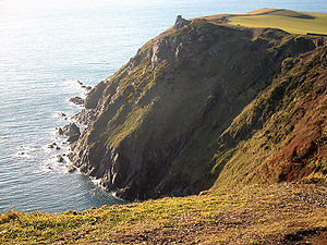
Bolt Tail
Encyclopedia
Headland
A headland is a point of land, usually high and often with a sheer drop, that extends out into a body of water.Headland can also refer to:*Headlands and bays*headLand, an Australian television series...
in Devon
Devon
Devon is a large county in southwestern England. The county is sometimes referred to as Devonshire, although the term is rarely used inside the county itself as the county has never been officially "shired", it often indicates a traditional or historical context.The county shares borders with...
, England
England
England is a country that is part of the United Kingdom. It shares land borders with Scotland to the north and Wales to the west; the Irish Sea is to the north west, the Celtic Sea to the south west, with the North Sea to the east and the English Channel to the south separating it from continental...
. It is located immediately to the southwest of Hope Cove
Hope Cove
Hope Cove is a small seaside village within the civil parish of South Huish in South Hams District, Devon, England. It is located some 5 miles west of Salcombe and 5 miles south-west of Kingsbridge. It has two beaches, and is sheltered by the headland of Bolt Tail.Historically, the village falls...
in the South Hams
South Hams
South Hams is a local government district on the south coast of Devon, England with its headquarters in the town of Totnes. It contains the towns of Dartmouth, Kingsbridge, Ivybridge, Salcombe — the largest of which is Ivybridge with a population of 16,056....
district, at grid reference
Grid reference
Grid references define locations on maps using Cartesian coordinates. Grid lines on maps define the coordinate system, and are numbered to provide a unique reference to features....
.
Bolt Tail is the site of an Iron Age
Iron Age
The Iron Age is the archaeological period generally occurring after the Bronze Age, marked by the prevalent use of iron. The early period of the age is characterized by the widespread use of iron or steel. The adoption of such material coincided with other changes in society, including differing...
promontory fort
Hill fort
A hill fort is a type of earthworks used as a fortified refuge or defended settlement, located to exploit a rise in elevation for defensive advantage. They are typically European and of the Bronze and Iron Ages. Some were used in the post-Roman period...
, although little evidence now remains of this structure, it occupied a classic promontory defended from inland by a linear earthwork at some 60 metres above sea level
Sea level
Mean sea level is a measure of the average height of the ocean's surface ; used as a standard in reckoning land elevation...
.
Bolt Tail marks the western end of a coastal walk through National Trust
National Trust for Places of Historic Interest or Natural Beauty
The National Trust for Places of Historic Interest or Natural Beauty, usually known as the National Trust, is a conservation organisation in England, Wales and Northern Ireland...
land to Salcombe
Salcombe
Salcombe is a town in the South Hams district of Devon, south west England. The town is close to the mouth of the Kingsbridge Estuary, built mostly on the steep west side of the estuary and lies within the South Devon Area of Outstanding Natural Beauty...
, via Bolberry Down
Bolberry Down
Bolberry Down is a clifftop area on the coast of Devon, England. The headland of Bolt Tail lies to the west and Bolt Head and the town of Salcombe to the east. It is one of the longest coastal areas owned by the National Trust and lies within the South Devon Area of Outstanding Natural Beauty.It...
and Bolt Head at the mouth of the Salcombe Estuary.
On a day with good visibility it is possible to see far down the coast into Cornwall
Cornwall
Cornwall is a unitary authority and ceremonial county of England, within the United Kingdom. It is bordered to the north and west by the Celtic Sea, to the south by the English Channel, and to the east by the county of Devon, over the River Tamar. Cornwall has a population of , and covers an area of...
, as far as Dodman Point
Dodman Point
Dodman Point is a high headland near Mevagissey, Cornwall. It was once an Iron Age promontory fort. At its seaward end is a large granite cross, erected to help protect shipping from this headland...
. Under very exceptional atmospheric conditions the Lizard Point
Lizard Point, Cornwall
Lizard Point in Cornwall is at the southern tip of the Lizard Peninsula. It is situated half-a-mile south of Lizard village in the civil parish of Landewednack and approximately 11 miles southeast of Helston....
in Cornwall
Cornwall
Cornwall is a unitary authority and ceremonial county of England, within the United Kingdom. It is bordered to the north and west by the Celtic Sea, to the south by the English Channel, and to the east by the county of Devon, over the River Tamar. Cornwall has a population of , and covers an area of...
is visible from Bolt Tail.