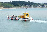
Black Tor Ferry
Encyclopedia

Ferry
A ferry is a form of transportation, usually a boat, but sometimes a ship, used to carry primarily passengers, and sometimes vehicles and cargo as well, across a body of water. Most ferries operate on regular, frequent, return services...
which crosses the tidal River Camel
River Camel
The River Camel is a river in Cornwall, UK. It rises on the edge of Bodmin Moor and together with its tributaries drains a considerable part of North Cornwall. The river issues into the Celtic Sea area of the Atlantic Ocean between Stepper Point and Pentire Point having covered a distance of...
in north Cornwall
Cornwall
Cornwall is a unitary authority and ceremonial county of England, within the United Kingdom. It is bordered to the north and west by the Celtic Sea, to the south by the English Channel, and to the east by the county of Devon, over the River Tamar. Cornwall has a population of , and covers an area of...
, United Kingdom
United Kingdom
The United Kingdom of Great Britain and Northern IrelandIn the United Kingdom and Dependencies, other languages have been officially recognised as legitimate autochthonous languages under the European Charter for Regional or Minority Languages...
. The ferry carries pedestrians and cyclists only (not vehicles).
History
There has been a ferry at Black Rock Passage since 1337, the right originally belonging ot the Ducky manor of Penmayne. Today the ferry operates on demand, every day in the summer and Monday to Saturday in the winter. The service being operated by Padstow Harbour Commissioners.Route
The ferry connects the town of PadstowPadstow
Padstow is a town, civil parish and fishing port on the north coast of Cornwall, England, United Kingdom. The town is situated on the west bank of the River Camel estuary approximately five miles northwest of Wadebridge, ten miles northwest of Bodmin and ten miles northeast of Newquay...
on the west bank of the river to the village of Rock
Rock, Cornwall
Rock is a coastal village in Cornwall, United Kingdom. It is situated opposite Padstow on the northeast bank of the River Camel estuary. The village is in the civil parish of St Minver Lowlands approximately four miles northwest of Wadebridge.-Geography:The main residential area is set back from...
on the east bank. The route of the 630 miles (1,013.9 km) long South West Coast Path
South West Coast Path
The South West Coast Path is Britain's longest waymarked long-distance footpath and a National Trail. It stretches for , running from Minehead in Somerset, along the coasts of Devon and Cornwall, to Poole Harbour in Dorset. Since it rises and falls with every river mouth, it is also one of the more...
utilises the ferry.

