
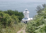
Tater Du Lighthouse
Encyclopedia
Tater Du Lighthouse is Cornwall
's most recently built lighthouse. The construction of the lighthouse came out of the tragedy of losing a small Spanish coaster
called the Juan Ferrer on the 23rd of October 1963, on the nearby Boscawen Point, the vessel capsized with the loss of 11 lives. After the tragedy the Newlyn and Mousehole Fishermen's Association put pressure on Trinity House
for a lighthouse to be built, stating that similar tragedies could happen again. Designed by Michael H. Crisp, the lighthouse was constructed with a completely automatic installation which is remotely controlled from the Trinity House depot in Penzance
. The lighthouse, built with concrete blocks, was completed by July 1965.
The short building houses a 7 foot 1 inch lantern with an electric light which is powered from batteries which are charged from mains electricity during the day. The light is 3 white lights flashed every 15 seconds, with a range of 23 miles. There is a separate red fixed light that shows in the line over the Runnelstone Rock
. The fog signal was originally a series (72 in total) of Tannoy units built into the lighthouse tower. This was replaced by a short-range Pharos Marine Omnidirectional electric emitter sounding the same characteristic of two one second blasts every 30 seconds during fog.
This lighthouse looks out over the Inner and Outer Bucks, two rocks that partially show at low water, and where in 1868 the SS Garonne was lost. They form a popular sub-aqua dive site. The nearest point for launching a dive-boat is Penzance, as Lamorna Cove just around the corner from The Bucks, does not allow launching from there.
The coastal slope and cliffs around the lighthouse are designated the Tater–du SSSI (a Site of Special Scientific Interest
) notified in 1992 because ″... it provides unique evidence of
the geological history of SW England during the Variscan orogeny
, in particular because of the occurrence of pillow lavas.″ The cliffs are also a Geological Conservation Review
site.
Cornwall
Cornwall is a unitary authority and ceremonial county of England, within the United Kingdom. It is bordered to the north and west by the Celtic Sea, to the south by the English Channel, and to the east by the county of Devon, over the River Tamar. Cornwall has a population of , and covers an area of...
's most recently built lighthouse. The construction of the lighthouse came out of the tragedy of losing a small Spanish coaster
Coastal trading vessel
Coastal trading vessels, also known as coasters, are shallow-hulled ships used for trade between locations on the same island or continent. Their shallow hulls mean that they can get through reefs where deeper-hulled sea-going ships usually cannot....
called the Juan Ferrer on the 23rd of October 1963, on the nearby Boscawen Point, the vessel capsized with the loss of 11 lives. After the tragedy the Newlyn and Mousehole Fishermen's Association put pressure on Trinity House
Trinity House
The Corporation of Trinity House of Deptford Strond is the official General Lighthouse Authority for England, Wales and other British territorial waters...
for a lighthouse to be built, stating that similar tragedies could happen again. Designed by Michael H. Crisp, the lighthouse was constructed with a completely automatic installation which is remotely controlled from the Trinity House depot in Penzance
Penzance
Penzance is a town, civil parish, and port in Cornwall, England, in the United Kingdom. It is the most westerly major town in Cornwall and is approximately 75 miles west of Plymouth and 300 miles west-southwest of London...
. The lighthouse, built with concrete blocks, was completed by July 1965.
The short building houses a 7 foot 1 inch lantern with an electric light which is powered from batteries which are charged from mains electricity during the day. The light is 3 white lights flashed every 15 seconds, with a range of 23 miles. There is a separate red fixed light that shows in the line over the Runnelstone Rock
Runnel Stone
The Runnel Stone is a hazardous rock pinnacle situated about a mile south of Gwennap Head, Cornwall, United Kingdom that used to show above the surface at low water until a steamship struck it in 1923.-Marks:...
. The fog signal was originally a series (72 in total) of Tannoy units built into the lighthouse tower. This was replaced by a short-range Pharos Marine Omnidirectional electric emitter sounding the same characteristic of two one second blasts every 30 seconds during fog.
This lighthouse looks out over the Inner and Outer Bucks, two rocks that partially show at low water, and where in 1868 the SS Garonne was lost. They form a popular sub-aqua dive site. The nearest point for launching a dive-boat is Penzance, as Lamorna Cove just around the corner from The Bucks, does not allow launching from there.
The coastal slope and cliffs around the lighthouse are designated the Tater–du SSSI (a Site of Special Scientific Interest
Site of Special Scientific Interest
A Site of Special Scientific Interest is a conservation designation denoting a protected area in the United Kingdom. SSSIs are the basic building block of site-based nature conservation legislation and most other legal nature/geological conservation designations in Great Britain are based upon...
) notified in 1992 because ″... it provides unique evidence of
the geological history of SW England during the Variscan orogeny
Orogeny
Orogeny refers to forces and events leading to a severe structural deformation of the Earth's crust due to the engagement of tectonic plates. Response to such engagement results in the formation of long tracts of highly deformed rock called orogens or orogenic belts...
, in particular because of the occurrence of pillow lavas.″ The cliffs are also a Geological Conservation Review
Geological Conservation Review
The Geological Conservation Review is produced by the UK's Joint Nature Conservation Committee and is designed to identify those sites of national and international importance needed to show all the key scientific elements of the geological and geomorphological features of Britain...
site.