
Cliff
Encyclopedia

Geography
Geography is the science that studies the lands, features, inhabitants, and phenomena of Earth. A literal translation would be "to describe or write about the Earth". The first person to use the word "geography" was Eratosthenes...
and geology
Geology
Geology is the science comprising the study of solid Earth, the rocks of which it is composed, and the processes by which it evolves. Geology gives insight into the history of the Earth, as it provides the primary evidence for plate tectonics, the evolutionary history of life, and past climates...
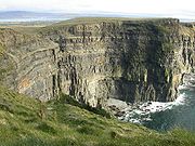
, a cliff is a significant vertical, or near vertical, rock exposure. Cliffs are formed as erosion
Erosion
Erosion is when materials are removed from the surface and changed into something else. It only works by hydraulic actions and transport of solids in the natural environment, and leads to the deposition of these materials elsewhere...
landform
Landform
A landform or physical feature in the earth sciences and geology sub-fields, comprises a geomorphological unit, and is largely defined by its surface form and location in the landscape, as part of the terrain, and as such, is typically an element of topography...
s due to the processes of erosion and weathering
Weathering
Weathering is the breaking down of rocks, soils and minerals as well as artificial materials through contact with the Earth's atmosphere, biota and waters...
that produce them. Cliffs are common on coast
Coast
A coastline or seashore is the area where land meets the sea or ocean. A precise line that can be called a coastline cannot be determined due to the dynamic nature of tides. The term "coastal zone" can be used instead, which is a spatial zone where interaction of the sea and land processes occurs...
s, in mountain
Mountain
Image:Himalaya_annotated.jpg|thumb|right|The Himalayan mountain range with Mount Everestrect 58 14 160 49 Chomo Lonzorect 200 28 335 52 Makalurect 378 24 566 45 Mount Everestrect 188 581 920 656 Tibetan Plateaurect 250 406 340 427 Rong River...
ous areas, escarpment
Escarpment
An escarpment is a steep slope or long cliff that occurs from erosion or faulting and separates two relatively level areas of differing elevations.-Description and variants:...
s and along river
River
A river is a natural watercourse, usually freshwater, flowing towards an ocean, a lake, a sea, or another river. In a few cases, a river simply flows into the ground or dries up completely before reaching another body of water. Small rivers may also be called by several other names, including...
s. Cliffs are usually formed by rock
Rock (geology)
In geology, rock or stone is a naturally occurring solid aggregate of minerals and/or mineraloids.The Earth's outer solid layer, the lithosphere, is made of rock. In general rocks are of three types, namely, igneous, sedimentary, and metamorphic...
that is resistant to erosion
Erosion
Erosion is when materials are removed from the surface and changed into something else. It only works by hydraulic actions and transport of solids in the natural environment, and leads to the deposition of these materials elsewhere...
and weathering
Weathering
Weathering is the breaking down of rocks, soils and minerals as well as artificial materials through contact with the Earth's atmosphere, biota and waters...
. Sedimentary rock
Sedimentary rock
Sedimentary rock are types of rock that are formed by the deposition of material at the Earth's surface and within bodies of water. Sedimentation is the collective name for processes that cause mineral and/or organic particles to settle and accumulate or minerals to precipitate from a solution....
s are most likely to form sandstone
Sandstone
Sandstone is a sedimentary rock composed mainly of sand-sized minerals or rock grains.Most sandstone is composed of quartz and/or feldspar because these are the most common minerals in the Earth's crust. Like sand, sandstone may be any colour, but the most common colours are tan, brown, yellow,...
, limestone
Limestone
Limestone is a sedimentary rock composed largely of the minerals calcite and aragonite, which are different crystal forms of calcium carbonate . Many limestones are composed from skeletal fragments of marine organisms such as coral or foraminifera....
, chalk
Chalk
Chalk is a soft, white, porous sedimentary rock, a form of limestone composed of the mineral calcite. Calcite is calcium carbonate or CaCO3. It forms under reasonably deep marine conditions from the gradual accumulation of minute calcite plates shed from micro-organisms called coccolithophores....
, and dolomite
Dolomite
Dolomite is a carbonate mineral composed of calcium magnesium carbonate CaMg2. The term is also used to describe the sedimentary carbonate rock dolostone....
. Igneous rock
Igneous rock
Igneous rock is one of the three main rock types, the others being sedimentary and metamorphic rock. Igneous rock is formed through the cooling and solidification of magma or lava...
s, such as granite
Granite
Granite is a common and widely occurring type of intrusive, felsic, igneous rock. Granite usually has a medium- to coarse-grained texture. Occasionally some individual crystals are larger than the groundmass, in which case the texture is known as porphyritic. A granitic rock with a porphyritic...
and basalt
Basalt
Basalt is a common extrusive volcanic rock. It is usually grey to black and fine-grained due to rapid cooling of lava at the surface of a planet. It may be porphyritic containing larger crystals in a fine matrix, or vesicular, or frothy scoria. Unweathered basalt is black or grey...
also often form cliffs.
An escarpment
Escarpment
An escarpment is a steep slope or long cliff that occurs from erosion or faulting and separates two relatively level areas of differing elevations.-Description and variants:...
(or scarp) is a type of cliff, formed by the movement of a geologic fault
Geologic fault
In geology, a fault is a planar fracture or discontinuity in a volume of rock, across which there has been significant displacement along the fractures as a result of earth movement. Large faults within the Earth's crust result from the action of tectonic forces...
, or a landslide
Landslide
A landslide or landslip is a geological phenomenon which includes a wide range of ground movement, such as rockfalls, deep failure of slopes and shallow debris flows, which can occur in offshore, coastal and onshore environments...
.
Most cliffs have some form of scree
Scree
Scree, also called talus, is a term given to an accumulation of broken rock fragments at the base of crags, mountain cliffs, or valley shoulders. Landforms associated with these materials are sometimes called scree slopes or talus piles...
slope at their base. In arid areas or under high cliffs, these are generally exposed jumbles of fallen rock. In areas of higher moisture, a soil
Soil
Soil is a natural body consisting of layers of mineral constituents of variable thicknesses, which differ from the parent materials in their morphological, physical, chemical, and mineralogical characteristics...
slope may obscure the talus. Many cliffs also feature tributary
Tributary
A tributary or affluent is a stream or river that flows into a main stem river or a lake. A tributary does not flow directly into a sea or ocean...
waterfall
Waterfall
A waterfall is a place where flowing water rapidly drops in elevation as it flows over a steep region or a cliff.-Formation:Waterfalls are commonly formed when a river is young. At these times the channel is often narrow and deep. When the river courses over resistant bedrock, erosion happens...
s or rock shelter
Rock shelter
A rock shelter is a shallow cave-like opening at the base of a bluff or cliff....
s. Sometimes a cliff peters out at the end of a ridge, with tea table
Tea table
Geologically speaking, a tea table is a rock formation that is a remnant of newer strata that have eroded away. A tea table is a type of rock column comprising discrete layers, usually of sedimentary rock, with the top layers being wider than the base due to greater resistance to erosion and...
s or other types of rock columns remaining.
The Ordnance Survey
Ordnance Survey
Ordnance Survey , an executive agency and non-ministerial government department of the Government of the United Kingdom, is the national mapping agency for Great Britain, producing maps of Great Britain , and one of the world's largest producers of maps.The name reflects its creation together with...
distinguishes between cliffs (continuous line along the top edge with projections down the face) and outcrops (continuous lines along lower edge).
Large and famous cliffs

Some of the largest cliffs on Earth
Earth
Earth is the third planet from the Sun, and the densest and fifth-largest of the eight planets in the Solar System. It is also the largest of the Solar System's four terrestrial planets...
are found underwater. For example, an 8,000-meter drop over a 4,250-meter span can be found at a ridge sitting inside the Kermadec Trench
Kermadec Trench
The Kermadec trench is one of Earth's deepest oceanic trenches, reaching a depth of . Formed by the subduction of the Pacific Plate under the Indo-Australian Plate, it runs over a thousand kilometres parallel with and to the east of the Kermadec Ridge and island arc, from near the northeastern tip...
.
The highest cliff (rock wall, mountain face
Mountain
Image:Himalaya_annotated.jpg|thumb|right|The Himalayan mountain range with Mount Everestrect 58 14 160 49 Chomo Lonzorect 200 28 335 52 Makalurect 378 24 566 45 Mount Everestrect 188 581 920 656 Tibetan Plateaurect 250 406 340 427 Rong River...
) in the world, is Nanga Parbat
Nanga Parbat
Nanga Parbat is the ninth highest mountain on Earth, the second highest mountain in Pakistan and among the eight-thousanders with a summit elevation of 8,126 meters...
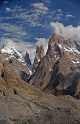
's Rupal Flank, which rises approximately 4,600 meters, or 15,000 feet, above its base. According to other sources, the highest cliff in the world, about 1,340 m high, is the east face of Great Trango
Trango Towers
The Trango Towers are a group of dramatic granite spires located on the north side of the Baltoro Glacier, in Baltistan, a district of the Gilgit-Baltistan region of Pakistan . They are part of the Baltoro Muztagh, a subrange of the Karakoram range. The Towers offer some of the largest cliffs and...
in the Karakoram
Karakoram
The Karakoram, or Karakorum , is a large mountain range spanning the borders between Pakistan, India and China, located in the regions of Gilgit-Baltistan , Ladakh , and Xinjiang region,...
mountains of northern Pakistan
Pakistan
Pakistan , officially the Islamic Republic of Pakistan is a sovereign state in South Asia. It has a coastline along the Arabian Sea and the Gulf of Oman in the south and is bordered by Afghanistan and Iran in the west, India in the east and China in the far northeast. In the north, Tajikistan...
. This uses a fairly stringent notion of cliff, as the 1,340 m figure refers to a nearly vertical headwall; adding in a very steep approach brings the total height to over 1,600 m.
The location of the world's highest sea cliffs depends also on the definition of 'cliff' that is used. The Guinness record books claim it is Kalaupapa, Hawaii
Kalaupapa, Hawaii
Kalaupapa is a small unincorporated community on the island of Molokai in the U.S. state of Hawaii, within Kalawao County.The village is located on the Kalaupapa peninsula at the base of the highest sea cliffs in the world, dropping about into the Pacific Ocean.- Volcanic origin :Kalaupapa...
, at 1,010 m high. Another contender is the north face of Mitre Peak, which drops 1683 meters to Milford Sound
Milford Sound
Milford Sound is a fjord in the south west of New Zealand's South Island, within Fiordland National Park, Piopiotahi Marine Reserve, and the Te Wahipounamu World Heritage site...
, New Zealand
New Zealand
New Zealand is an island country in the south-western Pacific Ocean comprising two main landmasses and numerous smaller islands. The country is situated some east of Australia across the Tasman Sea, and roughly south of the Pacific island nations of New Caledonia, Fiji, and Tonga...
. These are subject to a less stringent definition, as the average slope of these cliffs at Kaulapapa is about 1.7, corresponding to an angle of 60 degrees, and Mitre Peak is similar. A more vertical drop into the sea can be found at Maujit Qaqarssuasia (also known as the 'Thumbnail
Thumbnail (cliff)
The Thumbnail is the sea cliff located in South Greenland in Cape Farewell region, ca. 50 km to the east from the town of Nanortalik, over the west side of Torssukátak Fjord . It is recognized as the world's tallest sea cliff at nearly 1500 meters...
') which is situated in the Torssukátak fjord area at the very tip of South Greenland
Greenland
Greenland is an autonomous country within the Kingdom of Denmark, located between the Arctic and Atlantic Oceans, east of the Canadian Arctic Archipelago. Though physiographically a part of the continent of North America, Greenland has been politically and culturally associated with Europe for...
and drops 1,560 m near-vertically.
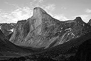
Considering a truly vertical drop, Mount Thor
Mount Thor
Mount Thor, officially gazetted as Thor Peak, is a mountain with an elevation of 1,675 m located in Auyuittuq National Park, on Baffin Island, Nunavut, Canada. The mountain is located northeast of Pangnirtung and features the Earth's greatest purely vertical drop at , with an average angle of 105...
on Baffin Island
Baffin Island
Baffin Island in the Canadian territory of Nunavut is the largest island in the Canadian Arctic Archipelago, the largest island in Canada and the fifth largest island in the world. Its area is and its population is about 11,000...
in Arctic
Arctic
The Arctic is a region located at the northern-most part of the Earth. The Arctic consists of the Arctic Ocean and parts of Canada, Russia, Greenland, the United States, Norway, Sweden, Finland, and Iceland. The Arctic region consists of a vast, ice-covered ocean, surrounded by treeless permafrost...
Canada
Canada
Canada is a North American country consisting of ten provinces and three territories. Located in the northern part of the continent, it extends from the Atlantic Ocean in the east to the Pacific Ocean in the west, and northward into the Arctic Ocean...
is often considered the highest at 1370 m (4500 ft) high in total (the top 480 m (1600 ft) is overhanging), and is said to give it the longest purely vertical drop on Earth at 1,250 m (4,100 ft). However, cliffs on Baffin Island
Baffin Island
Baffin Island in the Canadian territory of Nunavut is the largest island in the Canadian Arctic Archipelago, the largest island in Canada and the fifth largest island in the world. Its area is and its population is about 11,000...
, such as Polar Sun Spire
Polar sun spire
Polar Sun Spire is a peak in the Sam Ford Fjord of Baffin Island, Canada. The spire is notable for its spectacular north face and has been the scene of some amazing epic climbs. The first ascent was made in 1996 by Mark Synnott, Jeff Chapman and Warren Hollinger and involved a tremendous effort...
, or others in remote areas of Greenland may be higher.
The highest cliff in the solar system
Solar System
The Solar System consists of the Sun and the astronomical objects gravitationally bound in orbit around it, all of which formed from the collapse of a giant molecular cloud approximately 4.6 billion years ago. The vast majority of the system's mass is in the Sun...
may be Verona Rupes
Verona Rupes
Verona Rupes is a cliff on Miranda, a moon of Uranus. The cliff face has been estimated to be from 5 kilometers to 10 kilometers high, which makes it the tallest known cliff in the solar system....
, an approximately 20 km (12.4 mi) high fault scarp
Fault scarp
A fault scarp is the topographic expression of faulting attributed to the displacement of the land surface by movement along faults. They are exhibited either by differential movement and subsequent erosion along an old inactive geologic fault , or by a movement on a recent active fault...
on Miranda
Miranda (moon)
-External links:* at * at The Nine8 Planets* at Views of the Solar System* * from the...
, a moon of Uranus
Uranus
Uranus is the seventh planet from the Sun. It has the third-largest planetary radius and fourth-largest planetary mass in the Solar System. It is named after the ancient Greek deity of the sky Uranus , the father of Cronus and grandfather of Zeus...
.
The following is an incomplete list of cliffs of the world.
Asia
Above Sea- The Cliff of Kurosakitakao, MikurajimaMikurajimais a volcanic Japanese island in the Philippine Sea, administered by Tōkyō Metropolis and located approximately south of Tokyo and south-southeast of Miyakejima. It is one of the Izu Seven Islands group of the seven northern islands of the Izu archipelago....
, Tokyo prefecture, JapanJapanJapan is an island nation in East Asia. Located in the Pacific Ocean, it lies to the east of the Sea of Japan, China, North Korea, South Korea and Russia, stretching from the Sea of Okhotsk in the north to the East China Sea and Taiwan in the south...
480 m above Pacific OceanPacific OceanThe Pacific Ocean is the largest of the Earth's oceanic divisions. It extends from the Arctic in the north to the Southern Ocean in the south, bounded by Asia and Australia in the west, and the Americas in the east.At 165.2 million square kilometres in area, this largest division of the World... - Matengai, Oki IslandsOki Islandsare a group of islands in the southwestern part of the Sea of Japan and belong to Japan.-Geography:The Oki Islands are situated between 40 to 80 kilometers north of the coast of Honshū.The islands are of volcanic origin and have a total area of 346,1 km2...
, Shimane prefectureShimane Prefectureis a prefecture of Japan located in the Chūgoku region on Honshū island. The capital is Matsue. It is the second least populous prefecture in Japan, after its eastern neighbor Tottori. The prefecture has an area elongated from east to west facing the Chūgoku Mountain Range on the south side and to...
, JapanJapanJapan is an island nation in East Asia. Located in the Pacific Ocean, it lies to the east of the Sea of Japan, China, North Korea, South Korea and Russia, stretching from the Sea of Okhotsk in the north to the East China Sea and Taiwan in the south...
257 m above Sea of JapanSea of JapanThe Sea of Japan is a marginal sea of the western Pacific Ocean, between the Asian mainland, the Japanese archipelago and Sakhalin. It is bordered by Japan, North Korea, Russia and South Korea. Like the Mediterranean Sea, it has almost no tides due to its nearly complete enclosure from the Pacific... - Senba-kaigai, MinamiMinami, Tokushimais a town located in Kaifu District, Tokushima, Japan.It was founded on March 31, 2006 from the merger of the towns of Hiwasa and Yuki, both from Kaifu District....
, Tokushima prefectureTokushima Prefectureis a prefecture of Japan located on Shikoku island. The capital is the city of Tokushima.- Tokushima Prefecture and Myodo Prefecture :Long ago, Tokushima City belonged to a region known as Myōdō-gun...
, JapanJapanJapan is an island nation in East Asia. Located in the Pacific Ocean, it lies to the east of the Sea of Japan, China, North Korea, South Korea and Russia, stretching from the Sea of Okhotsk in the north to the East China Sea and Taiwan in the south...
250 m above Pacific OceanPacific OceanThe Pacific Ocean is the largest of the Earth's oceanic divisions. It extends from the Arctic in the north to the Southern Ocean in the south, bounded by Asia and Australia in the west, and the Americas in the east.At 165.2 million square kilometres in area, this largest division of the World... - Chibu-sekiheki, Oki IslandsOki Islandsare a group of islands in the southwestern part of the Sea of Japan and belong to Japan.-Geography:The Oki Islands are situated between 40 to 80 kilometers north of the coast of Honshū.The islands are of volcanic origin and have a total area of 346,1 km2...
, Shimane prefectureShimane Prefectureis a prefecture of Japan located in the Chūgoku region on Honshū island. The capital is Matsue. It is the second least populous prefecture in Japan, after its eastern neighbor Tottori. The prefecture has an area elongated from east to west facing the Chūgoku Mountain Range on the south side and to...
, JapanJapanJapan is an island nation in East Asia. Located in the Pacific Ocean, it lies to the east of the Sea of Japan, China, North Korea, South Korea and Russia, stretching from the Sea of Okhotsk in the north to the East China Sea and Taiwan in the south...
200 m above Sea of JapanSea of JapanThe Sea of Japan is a marginal sea of the western Pacific Ocean, between the Asian mainland, the Japanese archipelago and Sakhalin. It is bordered by Japan, North Korea, Russia and South Korea. Like the Mediterranean Sea, it has almost no tides due to its nearly complete enclosure from the Pacific... - Senzoku-dangai, Shinonsen, Hyogo prefectureHyogo Prefectureis a prefecture of Japan located in the Kansai region on Honshū island. The capital is Kobe.The prefecture's name was previously alternately spelled as Hiogo.- History :...
, JapanJapanJapan is an island nation in East Asia. Located in the Pacific Ocean, it lies to the east of the Sea of Japan, China, North Korea, South Korea and Russia, stretching from the Sea of Okhotsk in the north to the East China Sea and Taiwan in the south...
180 m above Sea of JapanSea of JapanThe Sea of Japan is a marginal sea of the western Pacific Ocean, between the Asian mainland, the Japanese archipelago and Sakhalin. It is bordered by Japan, North Korea, Russia and South Korea. Like the Mediterranean Sea, it has almost no tides due to its nearly complete enclosure from the Pacific... - Yoroinosode, KamiKami, Hyogo (Mikata)is a town located in Mikata District, Hyōgo, Japan. The town was formed on April 1, 2005 from the merger of the former town of Kasumi, from Kinosaki District, and the towns of Mikata and Muraoka, both from Mikata District....
, Hyogo prefectureHyogo Prefectureis a prefecture of Japan located in the Kansai region on Honshū island. The capital is Kobe.The prefecture's name was previously alternately spelled as Hiogo.- History :...
, JapanJapanJapan is an island nation in East Asia. Located in the Pacific Ocean, it lies to the east of the Sea of Japan, China, North Korea, South Korea and Russia, stretching from the Sea of Okhotsk in the north to the East China Sea and Taiwan in the south...
65 m above Sea of JapanSea of JapanThe Sea of Japan is a marginal sea of the western Pacific Ocean, between the Asian mainland, the Japanese archipelago and Sakhalin. It is bordered by Japan, North Korea, Russia and South Korea. Like the Mediterranean Sea, it has almost no tides due to its nearly complete enclosure from the Pacific... - Sandanbeki, Shirahama, Wakayama prefectureWakayama Prefectureis a prefecture of Japan located on the Kii Peninsula in the Kansai region on Honshū island. The capital is the city of Wakayama.- History :Present-day Wakayama is mostly the western part of the province of Kii.- 1953 Wakayama Prefecture flood disaster :...
, JapanJapanJapan is an island nation in East Asia. Located in the Pacific Ocean, it lies to the east of the Sea of Japan, China, North Korea, South Korea and Russia, stretching from the Sea of Okhotsk in the north to the East China Sea and Taiwan in the south...
60 m above Pacific OceanPacific OceanThe Pacific Ocean is the largest of the Earth's oceanic divisions. It extends from the Arctic in the north to the Southern Ocean in the south, bounded by Asia and Australia in the west, and the Americas in the east.At 165.2 million square kilometres in area, this largest division of the World... - Tojinbo, SakaiSakai, Fukuiis a city located in Fukui, Japan. It lies to the north of Fukui City. It was founded on March 20, 2006, by the merger of the towns of Harue, Maruoka, Mikuni, and Sakai of the former Sakai District, which was dissolved in this merger....
, Fukui prefectureFukui Prefectureis a prefecture of Japan located in the Chūbu region on Honshū island. The capital is the city of Fukui.- Prehistory :The Kitadani Dinosaur Quarry, on the Sugiyama River within the city limits of Katsuyama, has yielded the Fukuiraptor kitadaniensis and Fukuisaurus tetoriensis as well as an unnamed...
, JapanJapanJapan is an island nation in East Asia. Located in the Pacific Ocean, it lies to the east of the Sea of Japan, China, North Korea, South Korea and Russia, stretching from the Sea of Okhotsk in the north to the East China Sea and Taiwan in the south...
25 m above Sea of JapanSea of JapanThe Sea of Japan is a marginal sea of the western Pacific Ocean, between the Asian mainland, the Japanese archipelago and Sakhalin. It is bordered by Japan, North Korea, Russia and South Korea. Like the Mediterranean Sea, it has almost no tides due to its nearly complete enclosure from the Pacific...
Above Land
- Nanga ParbatNanga ParbatNanga Parbat is the ninth highest mountain on Earth, the second highest mountain in Pakistan and among the eight-thousanders with a summit elevation of 8,126 meters...
, Rupal Face, Azad Kashmir, Pakistan, 4,600 m - Ultar Sar southwest face, KarakoramKarakoramThe Karakoram, or Karakorum , is a large mountain range spanning the borders between Pakistan, India and China, located in the regions of Gilgit-Baltistan , Ladakh , and Xinjiang region,...
, Northern AreasNorthern AreasGilgit-Baltistan , is the northernmost political entity within Pakistan. It borders Pakistan's Khyber Pukhtunkhwa province to the west, Afghanistan's Wakhan Corridor to the north, China to the east and northeast, Azad Kashmir to the southwest, and Indian-administered Jammu and Kashmir to the...
, PakistanPakistanPakistan , officially the Islamic Republic of Pakistan is a sovereign state in South Asia. It has a coastline along the Arabian Sea and the Gulf of Oman in the south and is bordered by Afghanistan and Iran in the west, India in the east and China in the far northeast. In the north, Tajikistan...
, 3,000 m - Trango TowersTrango TowersThe Trango Towers are a group of dramatic granite spires located on the north side of the Baltoro Glacier, in Baltistan, a district of the Gilgit-Baltistan region of Pakistan . They are part of the Baltoro Muztagh, a subrange of the Karakoram range. The Towers offer some of the largest cliffs and...
: East Face Great Trango Tower, Baltoro MuztaghBaltoro MuztaghThe Baltoro Muztagh is a subrange of the Karakoram mountain range, in Baltistan region of the Gilgit-Baltistan province in northern Pakistan; and in Xinjiang, China. The crest of the range forms part of the Pakistan-China border....
, Northern AreasNorthern AreasGilgit-Baltistan , is the northernmost political entity within Pakistan. It borders Pakistan's Khyber Pukhtunkhwa province to the west, Afghanistan's Wakhan Corridor to the north, China to the east and northeast, Azad Kashmir to the southwest, and Indian-administered Jammu and Kashmir to the...
, PakistanPakistanPakistan , officially the Islamic Republic of Pakistan is a sovereign state in South Asia. It has a coastline along the Arabian Sea and the Gulf of Oman in the south and is bordered by Afghanistan and Iran in the west, India in the east and China in the far northeast. In the north, Tajikistan...
, 1,340 m (near vertical) - Uli Biaho TowersUli BiahoUli Biaho is a peak near Trango Towers and Baltoro Glacier in the Northern Areas of Pakistan. It consists of two main peaks, Uli Biaho Tower ; and Uli Biaho Peak , which as of 2006 was unclimbed.Uli Biaho Tower was climbed alpine-style via the direct East Face by John Roskelley et al...
, Baltoro GlacierBaltoro GlacierThe Baltoro Glacier, at 62 kilometers long, is one of the longest glaciers outside the polar regions. It is located in Baltistan, in the Gilgit-Baltistan region of Pakistan, and runs through part of the Karakoram mountain range. The Baltoro Muztagh lies to the north and east of the glacier, while...
, Northern AreasNorthern AreasGilgit-Baltistan , is the northernmost political entity within Pakistan. It borders Pakistan's Khyber Pukhtunkhwa province to the west, Afghanistan's Wakhan Corridor to the north, China to the east and northeast, Azad Kashmir to the southwest, and Indian-administered Jammu and Kashmir to the...
, PakistanPakistanPakistan , officially the Islamic Republic of Pakistan is a sovereign state in South Asia. It has a coastline along the Arabian Sea and the Gulf of Oman in the south and is bordered by Afghanistan and Iran in the west, India in the east and China in the far northeast. In the north, Tajikistan... - Baintha Brakk (The Ogre), Panmah MuztaghPanmah MuztaghThe Panmah Muztagh is a subrange of the Karakoram range, in Baltistan, a district of the Northern Areas of Pakistan. Its highest peaks are not particularly high by Karakoram standards, but they are exceedingly steep rock spires, unlike many of the peaks in the surrounding subranges...
, Northern AreasNorthern AreasGilgit-Baltistan , is the northernmost political entity within Pakistan. It borders Pakistan's Khyber Pukhtunkhwa province to the west, Afghanistan's Wakhan Corridor to the north, China to the east and northeast, Azad Kashmir to the southwest, and Indian-administered Jammu and Kashmir to the...
, PakistanPakistanPakistan , officially the Islamic Republic of Pakistan is a sovereign state in South Asia. It has a coastline along the Arabian Sea and the Gulf of Oman in the south and is bordered by Afghanistan and Iran in the west, India in the east and China in the far northeast. In the north, Tajikistan...
, 1,600 m - The Latok GroupLatokLatok I was first climbed in 1979 by a Japanese expedition led by Naoki Takada; the first summit party comprised Sin'e Matsumi, Tsuneo Shigehiro, Yu Watanabe, and they were followed three days later by Hideo Muto, Jun'ichi Oku, and Kota Endo...
, Panmah MuztaghPanmah MuztaghThe Panmah Muztagh is a subrange of the Karakoram range, in Baltistan, a district of the Northern Areas of Pakistan. Its highest peaks are not particularly high by Karakoram standards, but they are exceedingly steep rock spires, unlike many of the peaks in the surrounding subranges...
, Northern AreasNorthern AreasGilgit-Baltistan , is the northernmost political entity within Pakistan. It borders Pakistan's Khyber Pukhtunkhwa province to the west, Afghanistan's Wakhan Corridor to the north, China to the east and northeast, Azad Kashmir to the southwest, and Indian-administered Jammu and Kashmir to the...
, PakistanPakistanPakistan , officially the Islamic Republic of Pakistan is a sovereign state in South Asia. It has a coastline along the Arabian Sea and the Gulf of Oman in the south and is bordered by Afghanistan and Iran in the west, India in the east and China in the far northeast. In the north, Tajikistan...
, 1,800 m - SpantikSpantikSpantik or Golden Peak is a mountain in Spantik-Sosbun Mountains subrange of Karakoram. Its northwest face features an exceptionally hard climbing route known as the "Golden Pillar". It lies east of Diran and northeast of Malubiting.-Climbing:...
northwest face, KarakoramKarakoramThe Karakoram, or Karakorum , is a large mountain range spanning the borders between Pakistan, India and China, located in the regions of Gilgit-Baltistan , Ladakh , and Xinjiang region,...
, Northern AreasNorthern AreasGilgit-Baltistan , is the northernmost political entity within Pakistan. It borders Pakistan's Khyber Pukhtunkhwa province to the west, Afghanistan's Wakhan Corridor to the north, China to the east and northeast, Azad Kashmir to the southwest, and Indian-administered Jammu and Kashmir to the...
, PakistanPakistanPakistan , officially the Islamic Republic of Pakistan is a sovereign state in South Asia. It has a coastline along the Arabian Sea and the Gulf of Oman in the south and is bordered by Afghanistan and Iran in the west, India in the east and China in the far northeast. In the north, Tajikistan...
, 2,000 m - Shispare Sar southwest face, KarakoramKarakoramThe Karakoram, or Karakorum , is a large mountain range spanning the borders between Pakistan, India and China, located in the regions of Gilgit-Baltistan , Ladakh , and Xinjiang region,...
, Northern AreasNorthern AreasGilgit-Baltistan , is the northernmost political entity within Pakistan. It borders Pakistan's Khyber Pukhtunkhwa province to the west, Afghanistan's Wakhan Corridor to the north, China to the east and northeast, Azad Kashmir to the southwest, and Indian-administered Jammu and Kashmir to the...
, PakistanPakistanPakistan , officially the Islamic Republic of Pakistan is a sovereign state in South Asia. It has a coastline along the Arabian Sea and the Gulf of Oman in the south and is bordered by Afghanistan and Iran in the west, India in the east and China in the far northeast. In the north, Tajikistan...
, 3,200 m - Skamri Sar north face, KarakoramKarakoramThe Karakoram, or Karakorum , is a large mountain range spanning the borders between Pakistan, India and China, located in the regions of Gilgit-Baltistan , Ladakh , and Xinjiang region,...
, Northern AreasNorthern AreasGilgit-Baltistan , is the northernmost political entity within Pakistan. It borders Pakistan's Khyber Pukhtunkhwa province to the west, Afghanistan's Wakhan Corridor to the north, China to the east and northeast, Azad Kashmir to the southwest, and Indian-administered Jammu and Kashmir to the...
, PakistanPakistanPakistan , officially the Islamic Republic of Pakistan is a sovereign state in South Asia. It has a coastline along the Arabian Sea and the Gulf of Oman in the south and is bordered by Afghanistan and Iran in the west, India in the east and China in the far northeast. In the north, Tajikistan...
, 1,500 m - Hunza PeakHunza PeakHunza Peak lies in the westernmost subrange of the Karakoram range along with the Ladyfinger Peak . It lies on the southwest ridge of the Ultar Sar massif, the most southeasterly of the major groups of the Batura Muztagh...
south face, KarakoramKarakoramThe Karakoram, or Karakorum , is a large mountain range spanning the borders between Pakistan, India and China, located in the regions of Gilgit-Baltistan , Ladakh , and Xinjiang region,...
, Northern AreasNorthern AreasGilgit-Baltistan , is the northernmost political entity within Pakistan. It borders Pakistan's Khyber Pukhtunkhwa province to the west, Afghanistan's Wakhan Corridor to the north, China to the east and northeast, Azad Kashmir to the southwest, and Indian-administered Jammu and Kashmir to the...
, PakistanPakistanPakistan , officially the Islamic Republic of Pakistan is a sovereign state in South Asia. It has a coastline along the Arabian Sea and the Gulf of Oman in the south and is bordered by Afghanistan and Iran in the west, India in the east and China in the far northeast. In the north, Tajikistan...
, 1,700 m - Amin Brakk southeast face, KarakoramKarakoramThe Karakoram, or Karakorum , is a large mountain range spanning the borders between Pakistan, India and China, located in the regions of Gilgit-Baltistan , Ladakh , and Xinjiang region,...
, Northern AreasNorthern AreasGilgit-Baltistan , is the northernmost political entity within Pakistan. It borders Pakistan's Khyber Pukhtunkhwa province to the west, Afghanistan's Wakhan Corridor to the north, China to the east and northeast, Azad Kashmir to the southwest, and Indian-administered Jammu and Kashmir to the...
, PakistanPakistanPakistan , officially the Islamic Republic of Pakistan is a sovereign state in South Asia. It has a coastline along the Arabian Sea and the Gulf of Oman in the south and is bordered by Afghanistan and Iran in the west, India in the east and China in the far northeast. In the north, Tajikistan...
, 1,200 m (near vertical) - LhotseLhotseLhotse is the fourth highest mountain on Earth and is connected to Everest via the South Col. In addition to the main summit at 8,516 metres above sea level, Lhotse Middle is and Lhotse Shar is...
south face, Mahalangur HimalMahalangur HimalMahālangūr Himāl is a section of the Himalaya in northeast Nepal and south-central Tibet extending from the pass Nangpa La between Rolwaling Himal and Cho Oyu east to the Arun River. It includes Mount Everest, Lhotse, Makalu, and Cho Oyu) -- four of Earth's six highest peaks...
, NepalNepalNepal , officially the Federal Democratic Republic of Nepal, is a landlocked sovereign state located in South Asia. It is located in the Himalayas and bordered to the north by the People's Republic of China, and to the south, east, and west by the Republic of India...
, 2600 m - Meru PeakMeru PeakMeru Peak is a mountain which lies in the Himalayas, in the Uttarakhand region of India. It is within the Nanda Devi National Park, and is high. It is the site of the world's highest BASE Jump from 'Earth', by Glenn Singleman and Heather Swan from a height of in June 2006.The mountain has three...
, UttarakhandUttarakhandUttarakhand , formerly Uttaranchal, is a state in the northern part of India. It is often referred to as the Land of Gods due to the many holy Hindu temples and cities found throughout the state, some of which are among Hinduism's most spiritual and auspicious places of pilgrimage and worship...
, IndiaIndiaIndia , officially the Republic of India , is a country in South Asia. It is the seventh-largest country by geographical area, the second-most populous country with over 1.2 billion people, and the most populous democracy in the world...
, 1200 m - Ramon Crater, IsraelIsraelThe State of Israel is a parliamentary republic located in the Middle East, along the eastern shore of the Mediterranean Sea...
, 400 m - Various cliffs in the Ak-Su Valley of KyrgyzstanKyrgyzstanKyrgyzstan , officially the Kyrgyz Republic is one of the world's six independent Turkic states . Located in Central Asia, landlocked and mountainous, Kyrgyzstan is bordered by Kazakhstan to the north, Uzbekistan to the west, Tajikistan to the southwest and China to the east...
are high and steep.
Europe
Above Sea- HornelenHornelenHornelen is a mountain in the municipality of Bremanger, in Sogn og Fjordane county, Norway. At , it is the highest sea cliff in Europe, and has for a long time been used as a landmark for naval navigation. The horizontal distance from the summit to the sea shore is approximately...
, NorwayNorwayNorway , officially the Kingdom of Norway, is a Nordic unitary constitutional monarchy whose territory comprises the western portion of the Scandinavian Peninsula, Jan Mayen, and the Arctic archipelago of Svalbard and Bouvet Island. Norway has a total area of and a population of about 4.9 million...
, 860 m above Frøysjøen - Cape EnnibergCape EnnibergCape Enniberg is the northernmost point of the Faroe Islands, located on the Island of Viðoy. It is 754 m above sea level, altitude that makes it the second highest sea-cliff in Europe ....
, Faroe IslandsFaroe IslandsThe Faroe Islands are an island group situated between the Norwegian Sea and the North Atlantic Ocean, approximately halfway between Scotland and Iceland. The Faroe Islands are a self-governing territory within the Kingdom of Denmark, along with Denmark proper and Greenland...
, 750 m above North Atlantic - CroaghaunCroaghaunCroaghaun is a mountain in County Mayo, Ireland. At 688 metres , it has the highest cliffs in Ireland and the second highest sea cliffs in Europe ....
, Achill IslandAchill IslandAchill Island in County Mayo is the largest island off the coast of Ireland, and is situated off the west coast. It has a population of 2,700. Its area is . Achill is attached to the mainland by Michael Davitt Bridge, between the villages of Gob an Choire and Poll Raithní . A bridge was first...
, IrelandIrelandIreland is an island to the northwest of continental Europe. It is the third-largest island in Europe and the twentieth-largest island on Earth...
, 688 m above Atlantic OceanAtlantic OceanThe Atlantic Ocean is the second-largest of the world's oceanic divisions. With a total area of about , it covers approximately 20% of the Earth's surface and about 26% of its water surface area... - Vixía HerbeiraVixía HerbeiraVixia Herbeira, near San Andrés de Teixido in north-west Spain, is the second highest cliff face in continental Europe. It is 621 metres high.-External links:*...
, Northern Galicia, SpainSpainSpain , officially the Kingdom of Spain languages]] under the European Charter for Regional or Minority Languages. In each of these, Spain's official name is as follows:;;;;;;), is a country and member state of the European Union located in southwestern Europe on the Iberian Peninsula...
, 621 m above Atlantic OceanAtlantic OceanThe Atlantic Ocean is the second-largest of the world's oceanic divisions. With a total area of about , it covers approximately 20% of the Earth's surface and about 26% of its water surface area... - PreikestolenPreikestolenPreikestolen or Prekestolen, also known by the English translations of Preacher's Pulpit or Pulpit Rock, and by the old local name Hyvlatonnå , is a massive cliff 604 metres above Lysefjorden, opposite the Kjerag plateau, in Forsand, Ryfylke, Norway...
, NorwayNorwayNorway , officially the Kingdom of Norway, is a Nordic unitary constitutional monarchy whose territory comprises the western portion of the Scandinavian Peninsula, Jan Mayen, and the Arctic archipelago of Svalbard and Bouvet Island. Norway has a total area of and a population of about 4.9 million...
, 604 m above Lysefjorden - Slieve LeagueSlieve LeagueSlieve League, sometimes Slieve Leag or Slieve Liag , is a mountain on the Atlantic coast of County Donegal, Republic of Ireland. At , it has Ireland's highest sea cliffs...
, IrelandIrelandIreland is an island to the northwest of continental Europe. It is the third-largest island in Europe and the twentieth-largest island on Earth...
, 601 m above Atlantic OceanAtlantic OceanThe Atlantic Ocean is the second-largest of the world's oceanic divisions. With a total area of about , it covers approximately 20% of the Earth's surface and about 26% of its water surface area... - Cabo GirãoCabo GirãoCabo Girão is a lofty sea cliff located along the southern coast of the island of Madeira, in the Portuguese archipelago of Madeira. Cabo Girão is a popular lookout point, and starting point for hikers, as well as the location of the Encosta Cabo Girão a complex of 120 apartments located on the...
, MadeiraMadeiraMadeira is a Portuguese archipelago that lies between and , just under 400 km north of Tenerife, Canary Islands, in the north Atlantic Ocean and an outermost region of the European Union...
, 589 m above Atlantic OceanAtlantic OceanThe Atlantic Ocean is the second-largest of the world's oceanic divisions. With a total area of about , it covers approximately 20% of the Earth's surface and about 26% of its water surface area... - JaizkibelJaizkibelJaizkibel is mountain range of the Basque Country located east of Pasaia, north of Lezo and west of Hondarribia, in Spain, with 547 m at the highest point . The range stretches south-west to north-east, where it plunges into the sea at the Cape Higuer...
, SpainSpainSpain , officially the Kingdom of Spain languages]] under the European Charter for Regional or Minority Languages. In each of these, Spain's official name is as follows:;;;;;;), is a country and member state of the European Union located in southwestern Europe on the Iberian Peninsula...
, 547 m above the Bay of BiscayBay of BiscayThe Bay of Biscay is a gulf of the northeast Atlantic Ocean located south of the Celtic Sea. It lies along the western coast of France from Brest south to the Spanish border, and the northern coast of Spain west to Cape Ortegal, and is named in English after the province of Biscay, in the Spanish... - BeinisvørðBeinisvørðBeinisvørð is a 470 meter high sea cliff in Suðuroy, Faroe Islands, the highest sea cliff in Suðuroy. It is located between the villages of Lopra and Sumba. Beinisvørð has vertical cliffs facing the sea and a green slope down towards the village of Sumba...
, Faroe IslandsFaroe IslandsThe Faroe Islands are an island group situated between the Norwegian Sea and the North Atlantic Ocean, approximately halfway between Scotland and Iceland. The Faroe Islands are a self-governing territory within the Kingdom of Denmark, along with Denmark proper and Greenland...
, 470 m above North Atlantic - Conachair, St KildaSt Kilda, ScotlandSt Kilda is an isolated archipelago west-northwest of North Uist in the North Atlantic Ocean. It contains the westernmost islands of the Outer Hebrides of Scotland. The largest island is Hirta, whose sea cliffs are the highest in the United Kingdom and three other islands , were also used for...
, ScotlandScotlandScotland is a country that is part of the United Kingdom. Occupying the northern third of the island of Great Britain, it shares a border with England to the south and is bounded by the North Sea to the east, the Atlantic Ocean to the north and west, and the North Channel and Irish Sea to the...
427 m above Atlantic OceanAtlantic OceanThe Atlantic Ocean is the second-largest of the world's oceanic divisions. With a total area of about , it covers approximately 20% of the Earth's surface and about 26% of its water surface area... - Cap CanailleCap CanailleCap Canaille is a 1983 French drama film directed by Juliet Berto and Jean-Henri Roger. It was entered into the 33rd Berlin International Film Festival.-Cast:* Juliet Berto as Paula Baretto* Richard Bohringer as Robert Vergès...
, FranceFranceThe French Republic , The French Republic , The French Republic , (commonly known as France , is a unitary semi-presidential republic in Western Europe with several overseas territories and islands located on other continents and in the Indian, Pacific, and Atlantic oceans. Metropolitan France...
, 394 m above Mediterranean seaMediterranean SeaThe Mediterranean Sea is a sea connected to the Atlantic Ocean surrounded by the Mediterranean region and almost completely enclosed by land: on the north by Anatolia and Europe, on the south by North Africa, and on the east by the Levant...
is the highest sea cliff in France - St John's Head (Hoy Orkney Islands Scotland) at 335 m is the most vertical sea cliff in the UK
- Hangman cliffsHangman cliffsHangman cliffs are near Combe Martin on Devon's Exmoor coast.Great Hangman is high with a cliff face of . It is the highest sea cliff in England and the highest point on the South West Coast Path....
, DevonDevonDevon is a large county in southwestern England. The county is sometimes referred to as Devonshire, although the term is rarely used inside the county itself as the county has never been officially "shired", it often indicates a traditional or historical context.The county shares borders with...
318 m above Bristol ChannelBristol ChannelThe Bristol Channel is a major inlet in the island of Great Britain, separating South Wales from Devon and Somerset in South West England. It extends from the lower estuary of the River Severn to the North Atlantic Ocean...
is the highest sea cliff in EnglandEnglandEngland is a country that is part of the United Kingdom. It shares land borders with Scotland to the north and Wales to the west; the Irish Sea is to the north west, the Celtic Sea to the south west, with the North Sea to the east and the English Channel to the south separating it from continental... - Benwee HeadBenwee HeadBenwee Head Cliffs County MayoGaelic: An Bhinn BhuíHeight: 304 metres OS 1/50k Mapsheet: 22 for topGrid Ref: F816 443 Latitude: 54.333659 Longitude: -9.820924ITM: 481576 844301 Prominence: 230m Isolation: 5.4 km...
Cliffs, ErrisErrisErris is a barony in northwestern County Mayo in Ireland consisting of over , much of which is mountainous blanket bog. It has extensive sea coasts along its west and north boundaries. The main towns are Belmullet and Bangor Erris. The name Erris derives from the Irish 'Iar Ros' meaning 'western...
, Co. Mayo, IrelandIrelandIreland is an island to the northwest of continental Europe. It is the third-largest island in Europe and the twentieth-largest island on Earth...
, 304 m above Atlantic OceanAtlantic OceanThe Atlantic Ocean is the second-largest of the world's oceanic divisions. With a total area of about , it covers approximately 20% of the Earth's surface and about 26% of its water surface area... - Dingli Cliffs, MaltaMaltaMalta , officially known as the Republic of Malta , is a Southern European country consisting of an archipelago situated in the centre of the Mediterranean, south of Sicily, east of Tunisia and north of Libya, with Gibraltar to the west and Alexandria to the east.Malta covers just over in...
, 250 m above Mediterranean seaMediterranean SeaThe Mediterranean Sea is a sea connected to the Atlantic Ocean surrounded by the Mediterranean region and almost completely enclosed by land: on the north by Anatolia and Europe, on the south by North Africa, and on the east by the Levant... - High Cliff, between BoscastleBoscastleBoscastle is a village and fishing port on the north coast of Cornwall, England, in the civil parish of Forrabury and Minster. It is situated 14 miles south of Bude and 5 miles north-east of Tintagel....
and St GennysSt GennysSt Gennys is a coastal civil parish and small settlement in north Cornwall, United Kingdom.The hamlet of St Gennys is situated approximately seven miles southwest of Bude. It is on high ground half-a-mile north of the coastal village of Crackington Haven, the major settlement in the parish...
, 223 meters above Celtic SeaCeltic SeaThe Celtic Sea is the area of the Atlantic Ocean off the south coast of Ireland bounded to the east by Saint George's Channel; other limits include the Bristol Channel, the English Channel, and the Bay of Biscay, as well as adjacent portions of Wales, Cornwall, Devon, and Brittany... - Cliffs of MoherCliffs of MoherThe Cliffs of Moher are located in the parish of Liscannor at the south-western edge of the Burren area near Doolin, which is located in County Clare, Ireland....
, IrelandIrelandIreland is an island to the northwest of continental Europe. It is the third-largest island in Europe and the twentieth-largest island on Earth...
, 217 m above Atlantic OceanAtlantic OceanThe Atlantic Ocean is the second-largest of the world's oceanic divisions. With a total area of about , it covers approximately 20% of the Earth's surface and about 26% of its water surface area... - Boulby Cliffs, North Yorkshire , England, 203 m above the North SeaNorth SeaIn the southwest, beyond the Straits of Dover, the North Sea becomes the English Channel connecting to the Atlantic Ocean. In the east, it connects to the Baltic Sea via the Skagerrak and Kattegat, narrow straits that separate Denmark from Norway and Sweden respectively...
are the highest cliffs on the East Coast - Cap de la NauCap de la NauThe Cap de la Nau or Cabo de la Nao , literally “Cape of the Ship,” is a headland located central-eastern coastal Spain on the Gulf of Valencia, Mediterranean Sea...
, SpainSpainSpain , officially the Kingdom of Spain languages]] under the European Charter for Regional or Minority Languages. In each of these, Spain's official name is as follows:;;;;;;), is a country and member state of the European Union located in southwestern Europe on the Iberian Peninsula...
, 200 m above Mediterranean seaMediterranean SeaThe Mediterranean Sea is a sea connected to the Atlantic Ocean surrounded by the Mediterranean region and almost completely enclosed by land: on the north by Anatolia and Europe, on the south by North Africa, and on the east by the Levant... - Beachy HeadBeachy HeadBeachy Head is a chalk headland on the south coast of England, close to the town of Eastbourne in the county of East Sussex, immediately east of the Seven Sisters. The cliff there is the highest chalk sea cliff in Britain, rising to 162 m above sea level. The peak allows views of the south...
, EnglandEnglandEngland is a country that is part of the United Kingdom. It shares land borders with Scotland to the north and Wales to the west; the Irish Sea is to the north west, the Celtic Sea to the south west, with the North Sea to the east and the English Channel to the south separating it from continental...
, 162 m above the English ChannelEnglish ChannelThe English Channel , often referred to simply as the Channel, is an arm of the Atlantic Ocean that separates southern England from northern France, and joins the North Sea to the Atlantic. It is about long and varies in width from at its widest to in the Strait of Dover... - Møns KlintMøns KlintMøns Klint, , is a striking landmark and tourist attraction along the eastern coast of the Danish island of Møn in the Baltic Sea. The bright chalk cliffs stretch some 6 km from the park of in the north to the in the south. Some of the cliffs fall a sheer 120 m to the sea below...
, DenmarkDenmarkDenmark is a Scandinavian country in Northern Europe. The countries of Denmark and Greenland, as well as the Faroe Islands, constitute the Kingdom of Denmark . It is the southernmost of the Nordic countries, southwest of Sweden and south of Norway, and bordered to the south by Germany. Denmark...
, 143 m above Baltic SeaBaltic SeaThe Baltic Sea is a brackish mediterranean sea located in Northern Europe, from 53°N to 66°N latitude and from 20°E to 26°E longitude. It is bounded by the Scandinavian Peninsula, the mainland of Europe, and the Danish islands. It drains into the Kattegat by way of the Øresund, the Great Belt and... - White cliffs of DoverWhite cliffs of DoverThe White Cliffs of Dover are cliffs which form part of the British coastline facing the Strait of Dover and France. The cliffs are part of the North Downs formation. The cliff face, which reaches up to , owes its striking façade to its composition of chalk accentuated by streaks of black flint...
, EnglandEnglandEngland is a country that is part of the United Kingdom. It shares land borders with Scotland to the north and Wales to the west; the Irish Sea is to the north west, the Celtic Sea to the south west, with the North Sea to the east and the English Channel to the south separating it from continental...
, 100 m above the Strait of DoverStrait of DoverThe Strait of Dover or Dover Strait is the strait at the narrowest part of the English Channel. The shortest distance across the strait is from the South Foreland, 6 kilometres northeast of Dover in the county of Kent, England, to Cap Gris Nez, a cape near to Calais in the French of... - Strunjan cliff, SloveniaSloveniaSlovenia , officially the Republic of Slovenia , is a country in Central and Southeastern Europe touching the Alps and bordering the Mediterranean. Slovenia borders Italy to the west, Croatia to the south and east, Hungary to the northeast, and Austria to the north, and also has a small portion of...
, 80 m above the Adriatic SeaAdriatic SeaThe Adriatic Sea is a body of water separating the Italian Peninsula from the Balkan peninsula, and the system of the Apennine Mountains from that of the Dinaric Alps and adjacent ranges... - Snake IslandSnake Island (Black Sea)Snake Island, also known as Serpent Island, , is a Ukrainian island located in the Black Sea near the Danube Delta.The island is populated. A rural settlement of Bile was established in February 2007, which is part of the Vylkove city, Kiliya Raion, Odessa Oblast...
, UkraineUkraineUkraine is a country in Eastern Europe. It has an area of 603,628 km², making it the second largest contiguous country on the European continent, after Russia...
, 41 m above the Black SeaBlack SeaThe Black Sea is bounded by Europe, Anatolia and the Caucasus and is ultimately connected to the Atlantic Ocean via the Mediterranean and the Aegean seas and various straits. The Bosphorus strait connects it to the Sea of Marmara, and the strait of the Dardanelles connects that sea to the Aegean...
Above Land
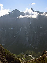
- Troll WallTroll WallThe Troll Wall is part of the mountain massif Trolltindene in the Romsdalen valley, near Åndalsnes and Molde, on the Norwegian west coast. Trollveggen is part of the Reinheimen National Park in the municipality of Rauma in Møre og Romsdal county. The Troll Wall is the tallest vertical rock face...
, NorwayNorwayNorway , officially the Kingdom of Norway, is a Nordic unitary constitutional monarchy whose territory comprises the western portion of the Scandinavian Peninsula, Jan Mayen, and the Arctic archipelago of Svalbard and Bouvet Island. Norway has a total area of and a population of about 4.9 million...
1,100 m above base - Mięguszowiecki SzczytMieguszowiecki SzczytMięguszowiecki Szczyt Wielki or the Mięguszowiecki Grand Peak is a mountain in the Tatra Mountains, Poland, located on the Slovak-Polish border....
north face rises to 1,043 m above Morskie OkoMorskie OkoMorskie Oko is the largest and fourth deepest lake in the Tatra Mountains...
lake level, High TatrasHigh TatrasHigh Tatras or High Tatra are a mountain range on the borders between Slovakia and Poland. They are a part of the Tatra Mountains...
, PolandPolandPoland , officially the Republic of Poland , is a country in Central Europe bordered by Germany to the west; the Czech Republic and Slovakia to the south; Ukraine, Belarus and Lithuania to the east; and the Baltic Sea and Kaliningrad Oblast, a Russian exclave, to the north... - KjeragKjeragKjerag or Kiragg is a Norwegian mountain, located in Lysefjorden, in Forsand municipality, Ryfylke, Rogaland. Its highest point is 1110 m above sea level, but its northern drop to Lysefjorden attracts most visitors. The drop is and is just by the famous Kjeragbolten, a 5 m³ big stone...
, NorwayNorwayNorway , officially the Kingdom of Norway, is a Nordic unitary constitutional monarchy whose territory comprises the western portion of the Scandinavian Peninsula, Jan Mayen, and the Arctic archipelago of Svalbard and Bouvet Island. Norway has a total area of and a population of about 4.9 million...
984 m. - Mały Kieżmarski Szczyt (north face), Tatra MountainsTatra MountainsThe Tatra Mountains, Tatras or Tatra , are a mountain range which forms a natural border between Slovakia and Poland, and are the highest mountain range in the Carpathian Mountains...
, SlovakiaSlovakiaThe Slovak Republic is a landlocked state in Central Europe. It has a population of over five million and an area of about . Slovakia is bordered by the Czech Republic and Austria to the west, Poland to the north, Ukraine to the east and Hungary to the south...
about 900 m denivelation (vertical rise) - GiewontGiewontGiewont is a mountain massif in the Tatra Mountains of Poland, and is 1895 metres AMSL at its highest.It comprises three peaks :* Small Giewont -...
(north face), Tatra MountainsTatra MountainsThe Tatra Mountains, Tatras or Tatra , are a mountain range which forms a natural border between Slovakia and Poland, and are the highest mountain range in the Carpathian Mountains...
, PolandPolandPoland , officially the Republic of Poland , is a country in Central Europe bordered by Germany to the west; the Czech Republic and Slovakia to the south; Ukraine, Belarus and Lithuania to the east; and the Baltic Sea and Kaliningrad Oblast, a Russian exclave, to the north...
, 852 m above Polana Strążyska gladeGlade (geography)A glade or clearing is an open area within a woodland. Glades are often grassy meadows under the canopy of deciduous trees such as red alder or quaking aspen in western North America. They also represent openings in forests where local conditions such as avalanches, poor soils, or fire damage have... - Kazalnica Mięguszowiecka, Tatra MountainsTatra MountainsThe Tatra Mountains, Tatras or Tatra , are a mountain range which forms a natural border between Slovakia and Poland, and are the highest mountain range in the Carpathian Mountains...
, PolandPolandPoland , officially the Republic of Poland , is a country in Central Europe bordered by Germany to the west; the Czech Republic and Slovakia to the south; Ukraine, Belarus and Lithuania to the east; and the Baltic Sea and Kaliningrad Oblast, a Russian exclave, to the north...
576 m above the Czarny Staw pod RysamiCzarny Staw pod RysamiCzarny Staw pod Rysami is a mountain lake on the Polish side of Mount Rysy in the Tatra mountains. At 1,583 m above sea level, it overlooks the nearby lake of Morskie Oko. Its maximum depth is 76 m... - The six great north faces of the AlpsGreat north faces of the AlpsIn mountaineering, the six great north faces of the Alps are known for their difficulty and great height. They are:*Cima Grande di Lavaredo*Eiger*Grandes Jorasses*Matterhorn*Petit Dru*Piz Badile...
(Cima Grande di Lavaredo 450 m, EigerEigerThe Eiger is a mountain in the Bernese Alps in Switzerland. It is the easternmost peak of a ridge crest that extends across the Mönch to the Jungfrau at 4,158 m...
1,500 m, Grandes JorassesGrandes JorassesThe Grandes Jorasses is a mountain in the Mont Blanc massif.The first ascent of the highest peak of the mountain was by Horace Walker with guides Melchior Anderegg, Johann Jaun and Julien Grange on 30 June 1868...
1,100 m, MatterhornMatterhornThe Matterhorn , Monte Cervino or Mont Cervin , is a mountain in the Pennine Alps on the border between Switzerland and Italy. Its summit is 4,478 metres high, making it one of the highest peaks in the Alps. The four steep faces, rising above the surrounding glaciers, face the four compass points...
1,350 m, Petit DruAiguille du DruThe Aiguille du Dru is a mountain in the Mont Blanc massif in the French Alps, lying to the east of the village of Les Praz in the Chamonix valley.The mountain has two summits:...
1,000 m, and Piz BadilePiz BadilePiz Badile is a mountain in the Bregaglia range in the Swiss canton of Graubünden and Italy, the border between the two countries running along the summit ridge. Its northeast face is considered one of the six great north faces of the Alps....
850 m)
North America
Granite
Granite is a common and widely occurring type of intrusive, felsic, igneous rock. Granite usually has a medium- to coarse-grained texture. Occasionally some individual crystals are larger than the groundmass, in which case the texture is known as porphyritic. A granitic rock with a porphyritic...
faces in the Arctic
Arctic
The Arctic is a region located at the northern-most part of the Earth. The Arctic consists of the Arctic Ocean and parts of Canada, Russia, Greenland, the United States, Norway, Sweden, Finland, and Iceland. The Arctic region consists of a vast, ice-covered ocean, surrounded by treeless permafrost...
regions vie for the title of 'highest purely vertical drop on Earth', but reliable measurements are not always available. The possible contenders include (measurements are approximate):
- Mount ThorMount ThorMount Thor, officially gazetted as Thor Peak, is a mountain with an elevation of 1,675 m located in Auyuittuq National Park, on Baffin Island, Nunavut, Canada. The mountain is located northeast of Pangnirtung and features the Earth's greatest purely vertical drop at , with an average angle of 105...
, Baffin IslandBaffin IslandBaffin Island in the Canadian territory of Nunavut is the largest island in the Canadian Arctic Archipelago, the largest island in Canada and the fifth largest island in the world. Its area is and its population is about 11,000...
, CanadaCanadaCanada is a North American country consisting of ten provinces and three territories. Located in the northern part of the continent, it extends from the Atlantic Ocean in the east to the Pacific Ocean in the west, and northward into the Arctic Ocean...
; 1,370 m (4,500 ft) total; top 480 m (1600 ft) is overhanging. This is commonly regarded as being the largest purely vertical drop on Earth at 1,250 m (4,100 ft). - The sheer north face of Polar Sun SpirePolar sun spirePolar Sun Spire is a peak in the Sam Ford Fjord of Baffin Island, Canada. The spire is notable for its spectacular north face and has been the scene of some amazing epic climbs. The first ascent was made in 1996 by Mark Synnott, Jeff Chapman and Warren Hollinger and involved a tremendous effort...
, in the Sam Ford fjord of Baffin IslandBaffin IslandBaffin Island in the Canadian territory of Nunavut is the largest island in the Canadian Arctic Archipelago, the largest island in Canada and the fifth largest island in the world. Its area is and its population is about 11,000...
, has been reported as exceeding Mount Thor's west face in height. - Ketil's west face in Tasermiut, GreenlandGreenlandGreenland is an autonomous country within the Kingdom of Denmark, located between the Arctic and Atlantic Oceans, east of the Canadian Arctic Archipelago. Though physiographically a part of the continent of North America, Greenland has been politically and culturally associated with Europe for...
(also known as God's ThumbnailThumbnail (cliff)The Thumbnail is the sea cliff located in South Greenland in Cape Farewell region, ca. 50 km to the east from the town of Nanortalik, over the west side of Torssukátak Fjord . It is recognized as the world's tallest sea cliff at nearly 1500 meters...
), has been reported as 1,400 m – 1,450 m high, (although some doubt has been cast on this).
Other notable cliffs include:
- Mount AsgardMount AsgardMount Asgard is a twin peaked mountain with two flat-topped cylindrical rock towers, separated by a saddle. It is located in Auyuittuq National Park, on the Cumberland Peninsula of Baffin Island, Nunavut, Canada. The peak is named after Asgard, the realm of the gods in Norse mythology...
, Baffin IslandBaffin IslandBaffin Island in the Canadian territory of Nunavut is the largest island in the Canadian Arctic Archipelago, the largest island in Canada and the fifth largest island in the world. Its area is and its population is about 11,000...
, CanadaCanadaCanada is a North American country consisting of ten provinces and three territories. Located in the northern part of the continent, it extends from the Atlantic Ocean in the east to the Pacific Ocean in the west, and northward into the Arctic Ocean...
; vertical drop of about 1,200 m (4,000 ft). - Vertical cliffs measured at approximately 1,000 m (3,280 ft) in height can be found along the Sam Ford fjord in Baffin Island, such as Walker Citadel, Kiguti Peak and Great Sail Peak, while there are others in Querbitter Fjord, and in Tasermiut, Greenland.
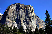
- El CapitanEl CapitanEl Capitan is a vertical rock formation in Yosemite National Park, located on the north side of Yosemite Valley, near its western end. The granite monolith extends about from base to summit along its tallest face, and is one of the world's favorite challenges for rock climbers.The formation was...
, Yosemite ValleyYosemite ValleyYosemite Valley is a glacial valley in Yosemite National Park in the western Sierra Nevada mountains of California, carved out by the Merced River. The valley is about long and up to a mile deep, surrounded by high granite summits such as Half Dome and El Capitan, and densely forested with pines...
, Sierra Nevada, CaliforniaCaliforniaCalifornia is a state located on the West Coast of the United States. It is by far the most populous U.S. state, and the third-largest by land area...
, United StatesUnited StatesThe United States of America is a federal constitutional republic comprising fifty states and a federal district...
; 900 m (3,000 ft) - Painted Wall in Black Canyon of the Gunnison National ParkBlack Canyon of the Gunnison National Parkthumb|upright|Black Canyon of the GunnisonBlack Canyon of the Gunnison National Park is a United States National Park located in western Colorado, and managed by the National Park Service...
, ColoradoColoradoColorado is a U.S. state that encompasses much of the Rocky Mountains as well as the northeastern portion of the Colorado Plateau and the western edge of the Great Plains...
, United StatesUnited StatesThe United States of America is a federal constitutional republic comprising fifty states and a federal district...
; 685 m (2,250 ft) - Northwest Face of Half DomeHalf DomeHalf Dome is a granite dome in Yosemite National Park, located in northeastern Mariposa County, California, at the eastern end of Yosemite Valley — possibly Yosemite's most familiar rock formation. The granite crest rises more than above the valley floor....
, near El CapitanEl CapitanEl Capitan is a vertical rock formation in Yosemite National Park, located on the north side of Yosemite Valley, near its western end. The granite monolith extends about from base to summit along its tallest face, and is one of the world's favorite challenges for rock climbers.The formation was...
; 1,340 m (4,400 ft) total, vertical portion about 610 m (2,000 ft) - The west face of Notch PeakNotch PeakNotch Peak is a distinctive summit located on Sawtooth Mountain in the House Range, west of Delta, Utah. The peak and the surrounding area are part of the Notch Peak Wilderness Study Area...
in the House RangeHouse RangeThe House Range is a north-south trending mountain range in west-central Utah. It is famous for Notch Peak, one of the tallest limestone cliffs in the world, and a fossil Lagerstätte of Cambrian age, which has an array of Burgess Shale type fauna, including Elrathia kingii, a trilobite that is...
of southwestern UtahUtahUtah is a state in the Western United States. It was the 45th state to join the Union, on January 4, 1896. Approximately 80% of Utah's 2,763,885 people live along the Wasatch Front, centering on Salt Lake City. This leaves vast expanses of the state nearly uninhabited, making the population the...
, United StatesUnited StatesThe United States of America is a federal constitutional republic comprising fifty states and a federal district...
; a carbonate rockCarbonate rockCarbonate rocks are a class of sedimentary rocks composed primarily of carbonate minerals. The two major types are limestone, which is composed of calcite or aragonite and dolostone, which is composed of the mineral dolomite .Calcite can be either dissolved by groundwater or precipitated by...
pure vertical drop of about 670 m (2,200 ft), with 4450 feet (1,356 m) from the top of the cliff to valley floor (bottom of the canyon below the notch) - East face of the West Temple in Zion National ParkZion National ParkZion National Park is located in the Southwestern United States, near Springdale, Utah. A prominent feature of the park is Zion Canyon, which is 15 miles long and up to half a mile deep, cut through the reddish and tan-colored Navajo Sandstone by the North Fork of the Virgin River...
, believed to be the tallest sandstone cliff in the world, 670 m - All faces of Devil's TowerDevils Tower National MonumentDevils Tower is an igneous intrusion or laccolith located in the Black Hills near Hulett and Sundance in Crook County, northeastern Wyoming, above the Belle Fourche River...
, WyomingWyomingWyoming is a state in the mountain region of the Western United States. The western two thirds of the state is covered mostly with the mountain ranges and rangelands in the foothills of the Eastern Rocky Mountains, while the eastern third of the state is high elevation prairie known as the High...
, United StatesUnited StatesThe United States of America is a federal constitutional republic comprising fifty states and a federal district...
, 195 m - Faces of ShiprockShiprockShiprock is a rock formation rising nearly above the high-desert plain on the Navajo Nation in San Juan County, New Mexico, USA. It has a peak elevation of above the sea level. It lies about southwest of the town of Shiprock, which is named for the peak...
, New MexicoNew MexicoNew Mexico is a state located in the southwest and western regions of the United States. New Mexico is also usually considered one of the Mountain States. With a population density of 16 per square mile, New Mexico is the sixth-most sparsely inhabited U.S...
, United StatesUnited StatesThe United States of America is a federal constitutional republic comprising fifty states and a federal district...
, 400 m - The North Face of North Twin PeakNorth Twin PeakNorth Twin is one of the two peaks that comprise The Twins massif located at the northeast corner of the Columbia Icefield in Jasper National Park, Alberta, Canada. The other lower peak is named South Twin . North Twin is the third highest peak in the Canadian Rockies, after Mount Robson and...
, Rocky MountainsRocky MountainsThe Rocky Mountains are a major mountain range in western North America. The Rocky Mountains stretch more than from the northernmost part of British Columbia, in western Canada, to New Mexico, in the southwestern United States...
, AlbertaAlbertaAlberta is a province of Canada. It had an estimated population of 3.7 million in 2010 making it the most populous of Canada's three prairie provinces...
, CanadaCanadaCanada is a North American country consisting of ten provinces and three territories. Located in the northern part of the continent, it extends from the Atlantic Ocean in the east to the Pacific Ocean in the west, and northward into the Arctic Ocean...
, 1,200 m - All walls of the Stawamus ChiefStawamus ChiefThe Stawamus Chief is a granite dome located adjacent to the town of Squamish, British Columbia. It towers over above the waters of nearby Howe Sound...
, SquamishSquamish, British ColumbiaSquamish is a community and a district municipality in the Canadian province of British Columbia, located at the north end of Howe Sound on the Sea to Sky Highway...
, British ColumbiaBritish ColumbiaBritish Columbia is the westernmost of Canada's provinces and is known for its natural beauty, as reflected in its Latin motto, Splendor sine occasu . Its name was chosen by Queen Victoria in 1858...
, CanadaCanadaCanada is a North American country consisting of ten provinces and three territories. Located in the northern part of the continent, it extends from the Atlantic Ocean in the east to the Pacific Ocean in the west, and northward into the Arctic Ocean...
, up to 500 m - Calvert CliffsCalvert Cliffs State ParkCalvert Cliffs State Park is a state park in Calvert County, Maryland, USA, situated on the Chesapeake Bay. On the 1612 John Smith map, the site is called "Rickard's Cliffes"...
along the Chesapeake BayChesapeake BayThe Chesapeake Bay is the largest estuary in the United States. It lies off the Atlantic Ocean, surrounded by Maryland and Virginia. The Chesapeake Bay's drainage basin covers in the District of Columbia and parts of six states: New York, Pennsylvania, Delaware, Maryland, Virginia, and West...
in MarylandMarylandMaryland is a U.S. state located in the Mid Atlantic region of the United States, bordering Virginia, West Virginia, and the District of Columbia to its south and west; Pennsylvania to its north; and Delaware to its east...
, 25 m - Mt Siyeh, Glacier National Park north face, 1,270 m
- Longs PeakLongs PeakLongs Peak is one of the 53 mountains with summits over 14,000 feet in Colorado. It can be prominently seen from Longmont, Colorado, as well as from the rest of the Colorado Front Range. It is named after Major Stephen Long, who explored the area in the 1820s...
Diamond, Rocky Mountain National ParkRocky Mountain National ParkRocky Mountain National Park is a national park located in the north-central region of the U.S. state of Colorado.It features majestic mountain views, a variety of wildlife, varied climates and environments—from wooded forests to mountain tundra—and easy access to back-country trails...
, ColoradoColoradoColorado is a U.S. state that encompasses much of the Rocky Mountains as well as the northeastern portion of the Colorado Plateau and the western edge of the Great Plains...
, 400 m - Royal GorgeRoyal GorgeThe Royal Gorge is a canyon on the Arkansas River near Cañon City, Colorado. With a width of at its base and a few hundred feet at its top, and a depth of in places, the 10-mile-long canyon is a narrow, steep gorge through the granite of Fremont Peak...
cliffs, ColoradoColoradoColorado is a U.S. state that encompasses much of the Rocky Mountains as well as the northeastern portion of the Colorado Plateau and the western edge of the Great Plains...
, 350 m - Doublet PeakDoublet PeakDoublet Peak is the fifth highest peak in the Wind River Range, Wyoming. The summit is immediately south of Dinwoody Glacier and just west of Mount Warren....
, southwest face, Wind River RangeWind River RangeThe Wind River Range , is a mountain range of the Rocky Mountains in western Wyoming in the United States. The range runs roughly NW-SE for approximately 100 miles . The Continental Divide follows the crest of the range and includes Gannett Peak, which at 13,804 feet , is the highest peak...
, WyomingWyomingWyoming is a state in the mountain region of the Western United States. The western two thirds of the state is covered mostly with the mountain ranges and rangelands in the foothills of the Eastern Rocky Mountains, while the eastern third of the state is high elevation prairie known as the High...
, 370 m - Pingora, southeast face, Wind River RangeWind River RangeThe Wind River Range , is a mountain range of the Rocky Mountains in western Wyoming in the United States. The range runs roughly NW-SE for approximately 100 miles . The Continental Divide follows the crest of the range and includes Gannett Peak, which at 13,804 feet , is the highest peak...
, WyomingWyomingWyoming is a state in the mountain region of the Western United States. The western two thirds of the state is covered mostly with the mountain ranges and rangelands in the foothills of the Eastern Rocky Mountains, while the eastern third of the state is high elevation prairie known as the High...
, 360 m - Warbonnet Peak, northeast face, Wind River RangeWind River RangeThe Wind River Range , is a mountain range of the Rocky Mountains in western Wyoming in the United States. The range runs roughly NW-SE for approximately 100 miles . The Continental Divide follows the crest of the range and includes Gannett Peak, which at 13,804 feet , is the highest peak...
, WyomingWyomingWyoming is a state in the mountain region of the Western United States. The western two thirds of the state is covered mostly with the mountain ranges and rangelands in the foothills of the Eastern Rocky Mountains, while the eastern third of the state is high elevation prairie known as the High...
, 470 m - Big Sandy Mountain, east face buttress, Wind River RangeWind River RangeThe Wind River Range , is a mountain range of the Rocky Mountains in western Wyoming in the United States. The range runs roughly NW-SE for approximately 100 miles . The Continental Divide follows the crest of the range and includes Gannett Peak, which at 13,804 feet , is the highest peak...
, WyomingWyomingWyoming is a state in the mountain region of the Western United States. The western two thirds of the state is covered mostly with the mountain ranges and rangelands in the foothills of the Eastern Rocky Mountains, while the eastern third of the state is high elevation prairie known as the High...
, 550 m - Temple Peak, east face, Wind River RangeWind River RangeThe Wind River Range , is a mountain range of the Rocky Mountains in western Wyoming in the United States. The range runs roughly NW-SE for approximately 100 miles . The Continental Divide follows the crest of the range and includes Gannett Peak, which at 13,804 feet , is the highest peak...
, WyomingWyomingWyoming is a state in the mountain region of the Western United States. The western two thirds of the state is covered mostly with the mountain ranges and rangelands in the foothills of the Eastern Rocky Mountains, while the eastern third of the state is high elevation prairie known as the High...
, 400 m - East Temple Peak, north face, Wind River RangeWind River RangeThe Wind River Range , is a mountain range of the Rocky Mountains in western Wyoming in the United States. The range runs roughly NW-SE for approximately 100 miles . The Continental Divide follows the crest of the range and includes Gannett Peak, which at 13,804 feet , is the highest peak...
, WyomingWyomingWyoming is a state in the mountain region of the Western United States. The western two thirds of the state is covered mostly with the mountain ranges and rangelands in the foothills of the Eastern Rocky Mountains, while the eastern third of the state is high elevation prairie known as the High...
, 450 m - Lost Temple Spire, Wind River RangeWind River RangeThe Wind River Range , is a mountain range of the Rocky Mountains in western Wyoming in the United States. The range runs roughly NW-SE for approximately 100 miles . The Continental Divide follows the crest of the range and includes Gannett Peak, which at 13,804 feet , is the highest peak...
, WyomingWyomingWyoming is a state in the mountain region of the Western United States. The western two thirds of the state is covered mostly with the mountain ranges and rangelands in the foothills of the Eastern Rocky Mountains, while the eastern third of the state is high elevation prairie known as the High...
, 430 m - Uncompahgre PeakUncompahgre PeakUncompahgre Peak is the sixth highest mountain peak in the U.S. state of Colorado and is the highest peak of the San Juan Mountains. It is located in the Uncompahgre Wilderness in the northern San Juans, in northern Hinsdale County approximately 7 miles west of the town of Lake City.Uncompahgre...
, northeast face, San Juan Range, ColoradoColoradoColorado is a U.S. state that encompasses much of the Rocky Mountains as well as the northeastern portion of the Colorado Plateau and the western edge of the Great Plains...
, 275 m (550 m rise above surrounding plateau)
South America
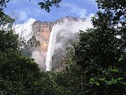
- Pared Sur Cerro Aconcagua. [Las Heras]], Mendoza, [Argentina]], 2,700 metros (desnivel desde la base de la pared hasta la cumbre).
- Scratched Stone (Pedra Riscada), São José do Divino/MG, Minas GeraisMinas GeraisMinas Gerais is one of the 26 states of Brazil, of which it is the second most populous, the third richest, and the fourth largest in area. Minas Gerais is the Brazilian state with the largest number of Presidents of Brazil, the current one, Dilma Rousseff, being one of them. The capital is the...
, BrazilBrazilBrazil , officially the Federative Republic of Brazil , is the largest country in South America. It is the world's fifth largest country, both by geographical area and by population with over 192 million people...
, 1,480 m - Autana Tepui, VenezuelaVenezuelaVenezuela , officially called the Bolivarian Republic of Venezuela , is a tropical country on the northern coast of South America. It borders Colombia to the west, Guyana to the east, and Brazil to the south...
stands 1,300 m above the forest floor. - Auyan Tepui, VenezuelaVenezuelaVenezuela , officially called the Bolivarian Republic of Venezuela , is a tropical country on the northern coast of South America. It borders Colombia to the west, Guyana to the east, and Brazil to the south...
, about 1,000 m (location of Angel Falls) (the falls are 979 m, the highest in the world) - Pared de Gocta, PeruPeruPeru , officially the Republic of Peru , is a country in western South America. It is bordered on the north by Ecuador and Colombia, on the east by Brazil, on the southeast by Bolivia, on the south by Chile, and on the west by the Pacific Ocean....
, 771 m - Fortaleza canyonFortaleza CanyonFortaleza Canyon is a canyon located in Serra Geral National Park in Cambará do Sul, Rio Grande do Sul, Brazil....
, Serra Geral National ParkSerra Geral National ParkSerra Geral National Park is a national park of Brazil. It was created in 1992, and is made up of two separate sections adjacent to Aparados da Serra National Park, totalling 17,300 hectares.-References:...
, BrazilBrazilBrazil , officially the Federative Republic of Brazil , is the largest country in South America. It is the world's fifth largest country, both by geographical area and by population with over 192 million people...
, about 720 m - Itaimbezinho canyon, Aparados da Serra National ParkAparados da Serra National ParkThe Aparados da Serra National Park is located in the Serra Geral range of Rio Grande do Sul state in the south of Brazil, between 29º07’—29º15’ S and 50º01’—50º10’ W. It has been created in 1959 as one of Brazil's first national parks, to protect the Itaimbezinho canyon...
, about 700 m - Pedra AzulPedra AzulPedra Azul is a Brazilian city in the state of Minas Gerais, located in the northeast of the state, in the Jequitinhonha River valley region. The population in 2007 was 24,851 in a total area of 1,619 km²....
, Pedra Azul State Park, Espirito SantoEspírito SantoEspírito Santo is one of the states of southeastern Brazil, often referred to by the abbreviation "ES". Its capital is Vitória and the largest city is Vila Velha. The name of the state means literally "holy spirit" after the Holy Ghost of Christianity...
, BrazilBrazilBrazil , officially the Federative Republic of Brazil , is the largest country in South America. It is the world's fifth largest country, both by geographical area and by population with over 192 million people...
, 540 m - Pão de Açúcar/Sugar Loaf, Rio de JaneiroRio de JaneiroRio de Janeiro , commonly referred to simply as Rio, is the capital city of the State of Rio de Janeiro, the second largest city of Brazil, and the third largest metropolitan area and agglomeration in South America, boasting approximately 6.3 million people within the city proper, making it the 6th...
, BrazilBrazilBrazil , officially the Federative Republic of Brazil , is the largest country in South America. It is the world's fifth largest country, both by geographical area and by population with over 192 million people...
, 395 m - Guarita Beach, TorresTorresTorres is a Portuguese and Spanish languages surname meaning "Towers". It may refer to the following people or fictional characters:-Athletes:* Abraham Torres, Venezuelan boxer* Andrés Torres, Puerto Rican baseball player...
, Rio Grande do SulRio Grande do SulRio Grande do Sul is the southernmost state in Brazil, and the state with the fifth highest Human Development Index in the country. In this state is located the southernmost city in the country, Chuí, on the border with Uruguay. In the region of Bento Gonçalves and Caxias do Sul, the largest wine...
, BrazilBrazilBrazil , officially the Federative Republic of Brazil , is the largest country in South America. It is the world's fifth largest country, both by geographical area and by population with over 192 million people... - All faces of Cerro TorreCerro TorreCerro Torre is one of the mountains of the Southern Patagonian Ice Field in South America. It is located in a region which is disputed between Argentina and Chile, west of Cerro Chalten . The peak is the highest in a four mountain chain: the other peaks are Torre Egger , Punta Herron, and Cerro...
, PatagoniaPatagoniaPatagonia is a region located in Argentina and Chile, integrating the southernmost section of the Andes mountains to the southwest towards the Pacific ocean and from the east of the cordillera to the valleys it follows south through Colorado River towards Carmen de Patagones in the Atlantic Ocean...
, ChileChileChile ,officially the Republic of Chile , is a country in South America occupying a long, narrow coastal strip between the Andes mountains to the east and the Pacific Ocean to the west. It borders Peru to the north, Bolivia to the northeast, Argentina to the east, and the Drake Passage in the far...
-ArgentinaArgentinaArgentina , officially the Argentine Republic , is the second largest country in South America by land area, after Brazil. It is constituted as a federation of 23 provinces and an autonomous city, Buenos Aires... - All faces of Cerro ChaltenCerro ChalténMonte Fitz Roy is a mountain located near El Chaltén village, in the Southern Patagonian Ice Field in Patagonia, on the border between Argentina and Chile...
(Fitz Roy), PatagoniaPatagoniaPatagonia is a region located in Argentina and Chile, integrating the southernmost section of the Andes mountains to the southwest towards the Pacific ocean and from the east of the cordillera to the valleys it follows south through Colorado River towards Carmen de Patagones in the Atlantic Ocean...
, ArgentinaArgentinaArgentina , officially the Argentine Republic , is the second largest country in South America by land area, after Brazil. It is constituted as a federation of 23 provinces and an autonomous city, Buenos Aires...
-ChileChileChile ,officially the Republic of Chile , is a country in South America occupying a long, narrow coastal strip between the Andes mountains to the east and the Pacific Ocean to the west. It borders Peru to the north, Bolivia to the northeast, Argentina to the east, and the Drake Passage in the far...
, 1200 m - Faces of the Torres del Paine group, PatagoniaPatagoniaPatagonia is a region located in Argentina and Chile, integrating the southernmost section of the Andes mountains to the southwest towards the Pacific ocean and from the east of the cordillera to the valleys it follows south through Colorado River towards Carmen de Patagones in the Atlantic Ocean...
, ChileChileChile ,officially the Republic of Chile , is a country in South America occupying a long, narrow coastal strip between the Andes mountains to the east and the Pacific Ocean to the west. It borders Peru to the north, Bolivia to the northeast, Argentina to the east, and the Drake Passage in the far...
, up to 900 m
* ciles
Africa
Above Sea- KogelbergKogelbergThe Kogelberg is a range of mountains along the False Bay coast in the Western Cape of South Africa. They form part of the Cape Fold Belt and start south of Grabouw and form a steep coastal range to Kleinmond. The Kogelberg area has the steepest and highest drop directly into the ocean of any...
, Western CapeWestern CapeThe Western Cape is a province in the south west of South Africa. The capital is Cape Town. Prior to 1994, the region that now forms the Western Cape was part of the much larger Cape Province...
, South AfricaSouth AfricaThe Republic of South Africa is a country in southern Africa. Located at the southern tip of Africa, it is divided into nine provinces, with of coastline on the Atlantic and Indian oceans...
, 1289 m (4,229 ft) above False BayFalse BayFalse Bay is a body of water defined by Cape Hangklip and the Cape Peninsula in the extreme South-West of South Africa.- Description and location :...
, Atlantic OceanAtlantic OceanThe Atlantic Ocean is the second-largest of the world's oceanic divisions. With a total area of about , it covers approximately 20% of the Earth's surface and about 26% of its water surface area... - Table MountainTable MountainTable Mountain is a flat-topped mountain forming a prominent landmark overlooking the city of Cape Town in South Africa, and is featured in the flag of Cape Town and other local government insignia. It is a significant tourist attraction, with many visitors using the cableway or hiking to the top...
, Cape TownCape TownCape Town is the second-most populous city in South Africa, and the provincial capital and primate city of the Western Cape. As the seat of the National Parliament, it is also the legislative capital of the country. It forms part of the City of Cape Town metropolitan municipality...
, Western Cape, South Africa, 1086 m (3,563 ft) above Atlantic Ocean - Fountain Peak, Cape Town, Western Cape, South Africa, 1060 m (3,477.7 ft) above Atlantic Ocean
- Risco de Faneque, Gran CanariaGran CanariaGran Canaria is the second most populous island of the Canary Islands, with a population of 838,397 which constitutes approximately 40% of the population of the archipelago...
, Canary IslandsCanary IslandsThe Canary Islands , also known as the Canaries , is a Spanish archipelago located just off the northwest coast of mainland Africa, 100 km west of the border between Morocco and the Western Sahara. The Canaries are a Spanish autonomous community and an outermost region of the European Union...
, SpainSpainSpain , officially the Kingdom of Spain languages]] under the European Charter for Regional or Minority Languages. In each of these, Spain's official name is as follows:;;;;;;), is a country and member state of the European Union located in southwestern Europe on the Iberian Peninsula...
, 1027 m (3,369.4 ft) above Atlantic Ocean - Blinkwater Peak, Cape Town, Western Cape, South Africa, 989 m (3,244.8 ft) above Atlantic Ocean
- Grootkop Buttress, Cape Town, Western Cape, South Africa, 857 m (2,811.7 ft) above Atlantic Ocean
- Valken Buttress, Cape Town, Western Cape, South Africa, 856 m (2,808.4 ft) above Atlantic Ocean
- Barrier Buttress, Cape Town, Western Cape, South Africa, 856 m (2,808.4 ft) above Atlantic Ocean
- Grotto Buttress, Cape Town, Western Cape, South Africa, 800 m (2,624.7 ft) above Atlantic Ocean
- Jubilee Buttress, Cape Town, Western Cape, South Africa, 800 m (2,624.7 ft) above Atlantic Ocean
- Kloof Buttress, Cape Town, Western Cape, South Africa, 800 m (2,624.7 ft) above Atlantic Ocean
- Porcupine Buttress, Cape Town, Western Cape, South Africa, 800 m (2,624.7 ft) above Atlantic Ocean
- Slangolie Buttress, Cape Town, Western Cape, South Africa, 788 m (2,585.3 ft) above Atlantic Ocean
- Postern Buttress, Cape Town, Western Cape, South Africa, 783 m (2,568.9 ft) above Atlantic Ocean
- Corridor Buttress / St Paul, Cape Town, Western Cape, South Africa, 768 m (2,519.7 ft) above Atlantic Ocean
- Judas Peak, Cape Town, Western Cape, South Africa, 758 m (2,486.9 ft) above Atlantic Ocean
- Separation Buttress, Cape Town, Western Cape, South Africa, 757 m (2,483.6 ft) above Atlantic Ocean
- Spring Buttress, Cape Town, Western Cape, South Africa, 746 m (2,447.5 ft) above Atlantic Ocean
- Wood Buttress, Cape Town, Western Cape, South Africa, 734 m (2,408.1 ft) above Atlantic Ocean
- Guguy's Cliffs, Gran Canaria, Canary Islands, Spain, 725 m (2,378.6 ft) above Atlantic Ocean
- Grove Buttress, Cape Town, Western Cape, South Africa, 713 m (2,339.2 ft) above Atlantic Ocean
- La Mérica, La GomeraLa GomeraLa Gomera is one of Spain's Canary Islands, located in the Atlantic Ocean off the coast of Africa. In area, it is the second-smallest of the seven main islands of this group.- Political organization :...
, Canary Islands, Spain, 711 m (2,332.7 ft) above Atlantic Ocean - Victoria Buttress, Cape Town, Western Cape, South Africa, 707 m (2,319.6 ft) above Atlantic Ocean
- Cairn Buttress, Cape Town, Western Cape, South Africa, 700 m (2,296.6 ft) above Atlantic Ocean
- Kleinkop Buttress, Cape Town, Western Cape, South Africa, 694 m (2,276.9 ft) above Atlantic Ocean
- Andén Verde, Gran Canaria, Canary Islands, Spain, 690 m (2,263.8 ft) above Atlantic Ocean
- KarbonkelbergKarbonkelbergKarbonkelberg is a small peak forming part of the Table Mountain National Park in Cape Town, South Africa. It forms a prominent landmark overlooking the harbour at Hout Bay. An unusual feature is that sand has been blown up it by the wind, causing a dune-like feature...
, Cape Town, Western Cape, South Africa, 653 m (2,142.4 ft) above Hout BayHout BayHout Bay is the name of a coastal suburb of Cape Town, South Africa with a mix of neighbourhoods from the very rich to the very poor. It lies in a valley on the Atlantic Seaboard of the Cape Peninsula and is twenty kilometres south of the Central Business District of Cape Town...
, Atlantic Ocean - La Peña's Cliffs, El HierroEl HierroEl Hierro, nicknamed Isla del Meridiano , is the smallest and farthest south and west of the Canary Islands , in the Atlantic Ocean off the coast of Africa, with a population of 10,162 .- Name :The name El Hierro, although phonetically identical to the Spanish word for 'iron', is generally thought...
, Canary Islands, Spain, 652 m (2,139.1 ft) above Atlantic Ocean - Los GigantesLos GigantesLos Gigantes is a resort town in the Santiago del Teide municipality on the west coast of the Canary Island Tenerife. Its main feature are the giant rock formations, Acantilados de Los Gigantes, that rise from the sea to a height of 500-800 metres after which the town has been named...
, TenerifeTenerifeTenerife is the largest and most populous island of the seven Canary Islands, it is also the most populated island of Spain, with a land area of 2,034.38 km² and 906,854 inhabitants, 43% of the total population of the Canary Islands. About five million tourists visit Tenerife each year, the...
, Canary Islands, Spain, 637 m (2,089.9 ft) above Atlantic Ocean - Chapman's PeakChapman's PeakChapman's Peak is the name of a mountain on the western side of the Cape Peninsula, about 15 kilometres south of Cape Town, South Africa. It is opposite the inlet on which the town of Hout Bay is centred....
, Western Cape, South Africa, 596 m (1,955.4 ft) above Atlantic Ocean - Anaga's CliffsMacizo de AnagaMacizo de Anaga is a mountain range in the northeastern part of the island of Tenerife in the Canary Islands. The highest point is 1,024 m . It extends to the Punta de Anaga in the northeast up to Cruz del Carmen in the southwest. Anaga features the mountain points of Bichuelo, Anambro,...
, Tenerife, Canary Islands, Spain, 592 m (1,942.3 ft) above Atlantic Ocean - Risco de Famara, LanzaroteLanzaroteLanzarote , a Spanish island, is the easternmost of the autonomous Canary Islands, in the Atlantic Ocean, approximately 125 km off the coast of Africa and 1,000 km from the Iberian Peninsula. Covering 845.9 km2, it stands as the fourth largest of the islands...
, Canary Islands, Spain, 580 m (1,902.9 ft) above Atlantic Ocean - Buenavista's Cliffs, Tenerife, Canary Islands, Spain, 546 m (1,791.3 ft) above Atlantic Ocean
- High Bluff, Prince Edward IslandPrince Edward IslandPrince Edward Island is a Canadian province consisting of an island of the same name, as well as other islands. The maritime province is the smallest in the nation in both land area and population...
, South Africa, 490 m (1,607.6 ft) above McNish Bay, Atlantic Ocean - Cape Hangklip, Western Cape, South Africa, 453.1 m (1,486.5 ft) above False Bay, Atlantic Ocean
- Punta Gaviota's Cliff, La PalmaLa PalmaLa Palma is the most north-westerly of the Canary Islands. La Palma has an area of 706 km2 making it the fifth largest of the seven main Canary Islands...
, Canary Islands, Spain, 435 m (1,427.2 ft) above Atlantic Ocean - Watertunnel cliffs, Marion Island, Prince Edward IslandsPrince Edward IslandsThe Prince Edward Islands are two small islands in the sub-antarctic Indian Ocean that are part of South Africa. The islands, named Marion Island and Prince Edward Island, are located at ....
, South Africa, ca. 350 m (1,148.3 ft) above Atlantic Ocean - The Sentinell, Western Cape, South Africa, 331 m (1,086 ft) above Hout Bay, Atlantic Ocean
- Cape PointCape PointCape Point is a promontory at the southeast corner of the Cape Peninsula, which is a mountainous and scenic landform that runs north-south for about thirty kilometres at the extreme southwestern tip of the African continent in the Republic of South Africa. Table Mountain and the city of Cape Town...
, Western Cape, South Africa, 249 m (816.9 ft) above Atlantic Ocean
Above Land
- Drakensberg AmphitheatreAmphitheatre (Drakensberg)The Amphitheatre is one of the geographical features of the Northern Drakensberg, South Africa, and is widely regarded as one of the most impressive cliff faces on earth...
, South Africa 1200 m (3,937 ft) above base, 5 km (3.1 mi) long. The Tugela FallsTugela FallsTugela Falls is the world's second highest waterfall. The total drop in five free-leaping falls is . They are located in the Drakensberg in the Royal Natal National Park in KwaZulu-Natal Province, Republic of South Africa. They are easily viewed after a heavy rain from the main travel road into...
, the world's second tallest waterfall, falls 948 m (3,110.2 ft) over the edge of the cliff face. - Mount Meru, Tanzania Caldera Cliffs, 1500 m (4,921.3 ft)
- Klein Winterhoek, Western Cape, South Africa, 1220 m (4,002.6 ft) above base.
- Wall of Fire, SwartbergSwartbergThe Swartberg mountains make up a mountain range that runs roughly east-west along the northern edge of the semi-arid Little Karoo in the Western Cape province of South Africa...
, Western Cape, South Africa 700 m (2,296.6 ft) cliff composed of vertically displaced quartzite - Tsaranoro, Madagascar, 700 m (2,296.6 ft) above base
- Karambony, Madagascar, 380 m (1,246.7 ft) above base.
- Innumerable peaks in the DrakensbergDrakensbergThe Drakensberg is the highest mountain range in Southern Africa, rising to in height. In Zulu, it is referred to as uKhahlamba , and in Sesotho as Maluti...
mountains of South Africa are spectacular cliff formations. The Drakensberg Range is regarded, together with Ethiopia's Simien Mountains, as one of the two finest erosional mountain ranges on Earth. Because of their near-unique geological formation, the range has an extraordinarily high percentage of cliff faces making up its length, particularly along the highest portion of the range. This portion of the range is virtually uninterrupted cliff faces, ranging from 600 m (1,968.5 ft) to 1200 m (3,937 ft) in height for almost 250 km (155.3 mi). Of all, the "Drakensberg Amphitheatre" (mentioned above) is probably the most impressive individual formation. Other notable cliffs include the Trojan Wall, Cleft PeakCleft PeakMurpheys Bluff is a mountain in South West Tasmania. It lies on the North West end of the Frankland Range jutting out towards the East from the range towards the impoundment Lake Pedder. It is South East of Murpheys Bluff and North West of Greycap....
, Injisuthi Triplets, Cathedral PeakCathedral PeakCathedral Peak may be any of several mountains, typically those with steep sides and towers reminiscent of a cathedral. In the United States alone, the USGS identifies 17 summits named "Cathedral Peak":In other countries:...
, Monk's Cowl, Mnweni Buttress, etc. The cliff faces of the Blyde River CanyonBlyde River CanyonThe Blyde River Canyon is a significant natural feature of South Africa, located in Mpumalanga, and forming the northern part of the Drakensberg escarpment. It is in length and is, on average, around deep. The Dam itself, when full, is at an altitude of 665m . The Canyon consists mostly of red...
, technically still part of the Drakensberg, may be over 800 m (2,624.7 ft), with the main face of the Swadini Buttress approximately 1000 m (3,280.8 ft) tall.
Oceania
Above Sea- Mitre Peak, New ZealandNew ZealandNew Zealand is an island country in the south-western Pacific Ocean comprising two main landmasses and numerous smaller islands. The country is situated some east of Australia across the Tasman Sea, and roughly south of the Pacific island nations of New Caledonia, Fiji, and Tonga...
, 1,683 m above Milford SoundMilford SoundMilford Sound is a fjord in the south west of New Zealand's South Island, within Fiordland National Park, Piopiotahi Marine Reserve, and the Te Wahipounamu World Heritage site... - The Lion, New ZealandNew ZealandNew Zealand is an island country in the south-western Pacific Ocean comprising two main landmasses and numerous smaller islands. The country is situated some east of Australia across the Tasman Sea, and roughly south of the Pacific island nations of New Caledonia, Fiji, and Tonga...
, 1,302 m above Milford SoundMilford SoundMilford Sound is a fjord in the south west of New Zealand's South Island, within Fiordland National Park, Piopiotahi Marine Reserve, and the Te Wahipounamu World Heritage site...
(drops from approx 1280m to sea level in a very short distance) - The Elephant, New ZealandNew ZealandNew Zealand is an island country in the south-western Pacific Ocean comprising two main landmasses and numerous smaller islands. The country is situated some east of Australia across the Tasman Sea, and roughly south of the Pacific island nations of New Caledonia, Fiji, and Tonga...
, has cliffs falling approx 1180m into Milford SoundMilford SoundMilford Sound is a fjord in the south west of New Zealand's South Island, within Fiordland National Park, Piopiotahi Marine Reserve, and the Te Wahipounamu World Heritage site...
, and a 900m drop in less than 300m horizontally - Kalaupapa, HawaiiHawaiiHawaii is the newest of the 50 U.S. states , and is the only U.S. state made up entirely of islands. It is the northernmost island group in Polynesia, occupying most of an archipelago in the central Pacific Ocean, southwest of the continental United States, southeast of Japan, and northeast of...
, 1,010 m above Pacific OceanPacific OceanThe Pacific Ocean is the largest of the Earth's oceanic divisions. It extends from the Arctic in the north to the Southern Ocean in the south, bounded by Asia and Australia in the west, and the Americas in the east.At 165.2 million square kilometres in area, this largest division of the World... - Great Australian BightGreat Australian BightThe Great Australian Bight is a large bight, or open bay, off the central and western portions of the southern coastline of mainland Australia.-Extent:...
- Ball's PyramidBall's PyramidBall's Pyramid is an erosional remnant of a shield volcano and caldera that formed about 7 million years ago. Ball's Pyramid is southeast of Lord Howe Island in the Pacific Ocean. It is high, while measuring only in length and across, making it the tallest volcanic stack in the world...
, a sea stack 562m high and only 200m across at its base - The Twelve Apostles (Victoria). A series of sea stacks in Australia, ranging from approximately 50 to 70 meters above the Bass StraitBass StraitBass Strait is a sea strait separating Tasmania from the south of the Australian mainland, specifically the state of Victoria.-Extent:The International Hydrographic Organization defines the limits of the Bass Strait as follows:...