
Cremyll
Encyclopedia

Cornwall
Cornwall is a unitary authority and ceremonial county of England, within the United Kingdom. It is bordered to the north and west by the Celtic Sea, to the south by the English Channel, and to the east by the county of Devon, over the River Tamar. Cornwall has a population of , and covers an area of...
, United Kingdom
United Kingdom
The United Kingdom of Great Britain and Northern IrelandIn the United Kingdom and Dependencies, other languages have been officially recognised as legitimate autochthonous languages under the European Charter for Regional or Minority Languages...
. It is situated approximately one mile (1.6km) west of Plymouth
Plymouth
Plymouth is a city and unitary authority area on the coast of Devon, England, about south-west of London. It is built between the mouths of the rivers Plym to the east and Tamar to the west, where they join Plymouth Sound...
.
Cremyll is on the Rame Peninsula
Rame Peninsula
The Rame Peninsula is a peninsula in south-east Cornwall, England, in the United Kingdom. The peninsula is surrounded by the English Channel to the south, Plymouth Sound to the east, and the estuary of the River Lynher to the north...
facing Plymouth Sound
Plymouth Sound
Plymouth Sound, or locally just The Sound, is a bay at Plymouth in England.Its southwest and southeast corners are Penlee Point in Cornwall and Wembury Point on Devon, a distance of about 3 nautical miles . Its northern limit is Plymouth Hoe giving a north-south distance of nearly 3 nautical miles...
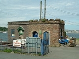
. The Cremyll Ferry
Cremyll Ferry
The Cremyll ferry runs across the River Tamar from Admirals Hard in Stonehouse, Plymouth, Devon to Cremyll in Cornwall. It is presently operated by Tamar Cruising, and runs approximately every 30 minutes, with a 10 minute crossing time.-History:...
carries foot passengers and cyclists from Cremyll to Plymouth. The ferry may well date back to the Saxon's
Saxons
The Saxons were a confederation of Germanic tribes originating on the North German plain. The Saxons earliest known area of settlement is Northern Albingia, an area approximately that of modern Holstein...
arrival in the eighth century and it was a link in the main southern route into Cornwall until the 1830s. There was a larger community here called West Stonehouse (compare with East Stonehouse
Stonehouse, Plymouth
East Stonehouse is one of three towns that were amalgamated into modern-day Plymouth. West Stonehouse was a village that is within the current Mount Edgcumbe Country Park in Cornwall...
) until it was burnt by the French in 1350. In medieval times the ferry was part of the manor of Stone-House, held by the Valletorts.
The main gates to Mount Edgcumbe Country Park
Mount Edgcumbe Country Park
Mount Edgcumbe Country Park is one of four designated Country Parks in Cornwall. It is situated on the Rame Peninsula, overlooking Plymouth Sound and the River Tamar....
and Mount Edgcumbe House
Mount Edgcumbe House
Mount Edgcumbe House is a stately home in south-east Cornwall. It is a Grade II listed building and the gardens are listed as Grade I in the Register of Parks and Gardens of Special Historic Interest in England....
are located in Cremyll.