
South Downs Way
Encyclopedia
The South Downs Way is a long distance footpath and bridleway running along the South Downs
in southern England
, and is one of 15 National Trails
in England and Wales
. The trail runs for 160 km (99.4 mi) from Winchester in Hampshire
, to Eastbourne
in East Sussex
with about 4150 m (13,615.5 ft) of ascent and descent.
and moves past Cheesefoot Head
, the towns of Petersfield
and Arundel
, the town of Steyning
, Devil's Dyke
viewpoint near Brighton
, followed by Ditchling Beacon
and miles of chalk
downland across to Beachy Head
, and finally ending in Eastbourne
.
Several youth hostels
are along the route to accommodate walkers. It also passes Birling Gap, a beach area with hotel and restaurant. The opportunity to swim here is irresistible to a perspiring rambler, despite the pebble
beach
.
At Rodmell
on the trail, Virginia Woolf
drowned herself in the River Ouse
in 1941.
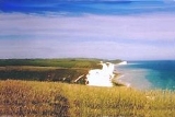
and the views are always interesting. Perhaps the most dramatic vistas are on the high chalk
cliffs on the Seven Sisters, Sussex
towards Beachy Head
and before the descent to Eastbourne. However, there are also superb views in clear weather from the ridgeway sections on the tops of the downs, especially on Ditchling Beacon
.
The Way lies within the South Downs National Park
. There is plenty of historic interest along the way, such as the Long Man of Wilmington
near Eastbourne. Diversions are needed to visit Brighton
or Lewes
, the latter town being of great beauty with an historic centre. Without exception it is a very well maintained and signposted route. While it crosses various villages for provisions much of it is surprisingly isolated and quiet considering the density of the population in south-east England.
It can be walked at a leisurely pace in about a week while a good walker, horse rider or cyclist would take two or three days. It is closed to motorised traffic along the route and this rule is generally observed.
Various events are held along the route; including the British Heart Foundation's
annual Randonee. Part or all of the 100 miles is cycled to raise funds for heart disease
, the fastest times are sub 8 hours with most riders taking under 14 hours.
South Downs
The South Downs is a range of chalk hills that extends for about across the south-eastern coastal counties of England from the Itchen Valley of Hampshire in the west to Beachy Head, near Eastbourne, East Sussex, in the east. It is bounded on its northern side by a steep escarpment, from whose...
in southern England
England
England is a country that is part of the United Kingdom. It shares land borders with Scotland to the north and Wales to the west; the Irish Sea is to the north west, the Celtic Sea to the south west, with the North Sea to the east and the English Channel to the south separating it from continental...
, and is one of 15 National Trails
National Trails
National Trails are long distance footpaths and bridleways in England and Wales. They are administered by Natural England and the Countryside Council for Wales, statutory agencies of the UK government....
in England and Wales
England and Wales
England and Wales is a jurisdiction within the United Kingdom. It consists of England and Wales, two of the four countries of the United Kingdom...
. The trail runs for 160 km (99.4 mi) from Winchester in Hampshire
Hampshire
Hampshire is a county on the southern coast of England in the United Kingdom. The county town of Hampshire is Winchester, a historic cathedral city that was once the capital of England. Hampshire is notable for housing the original birthplaces of the Royal Navy, British Army, and Royal Air Force...
, to Eastbourne
Eastbourne
Eastbourne is a large town and borough in East Sussex, on the south coast of England between Brighton and Hastings. The town is situated at the eastern end of the chalk South Downs alongside the high cliff at Beachy Head...
in East Sussex
East Sussex
East Sussex is a county in South East England. It is bordered by the counties of Kent, Surrey and West Sussex, and to the south by the English Channel.-History:...
with about 4150 m (13,615.5 ft) of ascent and descent.
Route
The undulating path begins in WinchesterWinchester
Winchester is a historic cathedral city and former capital city of England. It is the county town of Hampshire, in South East England. The city lies at the heart of the wider City of Winchester, a local government district, and is located at the western end of the South Downs, along the course of...
and moves past Cheesefoot Head
Cheesefoot Head
Cheesefoot Head is a large natural amphitheatre and beauty spot just outside Winchester, England. It is situated on the A272 road , and is rated a Site of Special Scientific Interest...
, the towns of Petersfield
Petersfield, Hampshire
Petersfield is a market town and civil parish in the East Hampshire district of Hampshire, England. It is north of Portsmouth, on the A3 road. The town has its own railway station on the Portsmouth Direct Line, the mainline rail link connecting Portsmouth and London. The town is situated on the...
and Arundel
Arundel
Arundel is a market town and civil parish in the South Downs of West Sussex in the south of England. It lies south southwest of London, west of Brighton, and east of the county town of Chichester. Other nearby towns include Worthing east southeast, Littlehampton to the south and Bognor Regis to...
, the town of Steyning
Steyning
Steyning is a small town and civil parish in the Horsham District of West Sussex, England. It is located at the north end of the River Adur gap in the South Downs, four miles north of Shoreham-by-Sea...
, Devil's Dyke
Devil's Dyke, Sussex
Devil's Dyke is a V-shaped valley on the South Downs Way in southern England, near Brighton and Hove. It is part of the Southern England Chalk Formation.Devil's Dyke is on the way to Brighton and is a big hill at the side of the road.-Geological history:...
viewpoint near Brighton
Brighton
Brighton is the major part of the city of Brighton and Hove in East Sussex, England on the south coast of Great Britain...
, followed by Ditchling Beacon
Ditchling Beacon
Ditchling Beacon is the third-highest point on the South Downs in south-east England, behind Butser Hill and Crown Tegleaze . It consists of a large chalk hill with a particularly steep northern face, covered with open grassland and sheep-grazing areas...
and miles of chalk
Chalk
Chalk is a soft, white, porous sedimentary rock, a form of limestone composed of the mineral calcite. Calcite is calcium carbonate or CaCO3. It forms under reasonably deep marine conditions from the gradual accumulation of minute calcite plates shed from micro-organisms called coccolithophores....
downland across to Beachy Head
Beachy Head
Beachy Head is a chalk headland on the south coast of England, close to the town of Eastbourne in the county of East Sussex, immediately east of the Seven Sisters. The cliff there is the highest chalk sea cliff in Britain, rising to 162 m above sea level. The peak allows views of the south...
, and finally ending in Eastbourne
Eastbourne
Eastbourne is a large town and borough in East Sussex, on the south coast of England between Brighton and Hastings. The town is situated at the eastern end of the chalk South Downs alongside the high cliff at Beachy Head...
.
Several youth hostels
Youth Hostels Association (England & Wales)
The Youth Hostels Association is a charitable organisation, registered with the Charity Commission, providing youth hostel accommodation in England and Wales...
are along the route to accommodate walkers. It also passes Birling Gap, a beach area with hotel and restaurant. The opportunity to swim here is irresistible to a perspiring rambler, despite the pebble
Pebble
A pebble is a clast of rock with a particle size of 4 to 64 millimetres based on the Krumbein phi scale of sedimentology. Pebbles are generally considered to be larger than granules and smaller than cobbles . A rock made predominantly of pebbles is termed a conglomerate...
beach
Beach
A beach is a geological landform along the shoreline of an ocean, sea, lake or river. It usually consists of loose particles which are often composed of rock, such as sand, gravel, shingle, pebbles or cobblestones...
.
At Rodmell
Rodmell
Rodmell is a small village and civil parish in the Lewes District of East Sussex, England. It is located three miles south-west of Lewes, on the Lewes to Newhaven road and is situated by the west banks of the River Ouse...
on the trail, Virginia Woolf
Virginia Woolf
Adeline Virginia Woolf was an English author, essayist, publisher, and writer of short stories, regarded as one of the foremost modernist literary figures of the twentieth century....
drowned herself in the River Ouse
River Ouse, Sussex
The River Ouse is a river in the counties of West and East Sussex in England.-Course:The river rises near Lower Beeding and runs eastwards into East Sussex, meandering narrowly and turning slowly southward...
in 1941.
Geography
Much of the South Downs Way is on high chalk downlandDownland
A downland is an area of open chalk hills. This term is especially used to describe the chalk countryside in southern England. Areas of downland are often referred to as Downs....
and the views are always interesting. Perhaps the most dramatic vistas are on the high chalk
Chalk
Chalk is a soft, white, porous sedimentary rock, a form of limestone composed of the mineral calcite. Calcite is calcium carbonate or CaCO3. It forms under reasonably deep marine conditions from the gradual accumulation of minute calcite plates shed from micro-organisms called coccolithophores....
cliffs on the Seven Sisters, Sussex
Seven Sisters, Sussex
The Seven Sisters are a series of chalk cliffs by the English Channel. They form part of the South Downs in East Sussex, between the towns of Seaford and Eastbourne in southern England. They are within the Seven Sisters Country Park...
towards Beachy Head
Beachy Head
Beachy Head is a chalk headland on the south coast of England, close to the town of Eastbourne in the county of East Sussex, immediately east of the Seven Sisters. The cliff there is the highest chalk sea cliff in Britain, rising to 162 m above sea level. The peak allows views of the south...
and before the descent to Eastbourne. However, there are also superb views in clear weather from the ridgeway sections on the tops of the downs, especially on Ditchling Beacon
Ditchling Beacon
Ditchling Beacon is the third-highest point on the South Downs in south-east England, behind Butser Hill and Crown Tegleaze . It consists of a large chalk hill with a particularly steep northern face, covered with open grassland and sheep-grazing areas...
.
The Way lies within the South Downs National Park
South Downs National Park
The South Downs National Park is England's newest National Park, having become fully operational on 1 April 2011. The park, covering an area of in southern England, stretches for from Winchester in the west to Eastbourne in the east through the counties of Hampshire, West Sussex and East Sussex...
. There is plenty of historic interest along the way, such as the Long Man of Wilmington
Long Man of Wilmington
The Long Man of Wilmington is a hill figure located in Wilmington, East Sussex, England on the steep slopes of Windover Hill, northwest of Eastbourne. The Long Man is tall and designed to look in proportion when viewed from below....
near Eastbourne. Diversions are needed to visit Brighton
Brighton
Brighton is the major part of the city of Brighton and Hove in East Sussex, England on the south coast of Great Britain...
or Lewes
Lewes
Lewes is the county town of East Sussex, England and historically of all of Sussex. It is a civil parish and is the centre of the Lewes local government district. The settlement has a history as a bridging point and as a market town, and today as a communications hub and tourist-oriented town...
, the latter town being of great beauty with an historic centre. Without exception it is a very well maintained and signposted route. While it crosses various villages for provisions much of it is surprisingly isolated and quiet considering the density of the population in south-east England.
It can be walked at a leisurely pace in about a week while a good walker, horse rider or cyclist would take two or three days. It is closed to motorised traffic along the route and this rule is generally observed.
Various events are held along the route; including the British Heart Foundation's
British Heart Foundation
The British Heart Foundation is a charity organisation in Britain that funds research, education, care and awareness campaigns aimed to prevent heart diseases in humans.-Foundation:...
annual Randonee. Part or all of the 100 miles is cycled to raise funds for heart disease
Heart disease
Heart disease, cardiac disease or cardiopathy is an umbrella term for a variety of diseases affecting the heart. , it is the leading cause of death in the United States, England, Canada and Wales, accounting for 25.4% of the total deaths in the United States.-Types:-Coronary heart disease:Coronary...
, the fastest times are sub 8 hours with most riders taking under 14 hours.