

Liberty Trail
Encyclopedia
A 28-mile trail between Ham Hill in Somerset
and Lyme Regis
in Dorset
, England.
in 1685. The rebels wore green sprig
s tucked into their hats to declare their support for Monmouth. Weapons that they carried included farm scythes
and other suitable agricultural tools.
 Ham Hill is 397 feet (121 m) at its highest point, and Lyme Regis is at sea level.
Below are six possible walking stages that may be used to traverse the Liberty Trail:
, Leland Trail
and River Parrett Trail
. Ham Hill Iron Age Hill Fort is one of the largest in Europe. Many local buildings are made from the local yellow Hamstone
. At Wayford
is Clapton Court Gardens, one of Somerset's more historic gardens that are open to the public. Forde Abbey
is situated on a curved section of the River Axe, its original purpose was as a Cistercian Monastery. It has a garden of some elegance which has won many awards. At this location the Dorset Jubilee Trail
crosses over the path of the Liberty Trail. Two other Iron Age Hill Forts may be seen at this stage, the first one is Lambert's Castle
and further on is Coney's Castle
. During clear weather conditions Chesil Beach
and Portland Bill
are visible, both are famous features of this part of the South coast of England. Lyme Regis is located to the west of Chesil Beach on the Jurassic Coast
, a place where many fossils may be found. The Cobb at Lyme Regis was the location for The French Lieutenant's Woman (film)
in 1981. The South West Coast Path
also leads into this part of the town.
 Sections of the Liberty Trail also form part of other trails in the area, such as the Macmillan Way West
, River Parrett Trail
, Wessex Ridgeway
.
Further detail of the Liberty Trail is available from Yeovil Tourist Information Centre and South Somerset Tourist Information.
Explorer map series:- 129 - Yeovil & Sherborne (Sherbourne), :-
116 - Lyme Regis & Bridport, provide the geographical details for this trail.
Somerset
The ceremonial and non-metropolitan county of Somerset in South West England borders Bristol and Gloucestershire to the north, Wiltshire to the east, Dorset to the south-east, and Devon to the south-west. It is partly bounded to the north and west by the Bristol Channel and the estuary of the...
and Lyme Regis
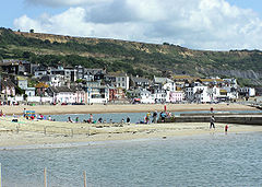
Lyme Regis
Lyme Regis is a coastal town in West Dorset, England, situated 25 miles west of Dorchester and east of Exeter. The town lies in Lyme Bay, on the English Channel coast at the Dorset-Devon border...
in Dorset
Dorset
Dorset , is a county in South West England on the English Channel coast. The county town is Dorchester which is situated in the south. The Hampshire towns of Bournemouth and Christchurch joined the county with the reorganisation of local government in 1974...
, England.
History
The route of the Liberty Trail route is based on information recorded by six rebels from various villages in Somerset and Dorset. Villagers from the two counties made their way to join the Protestant Monmouth RebellionMonmouth Rebellion
The Monmouth Rebellion,The Revolt of the West or The West Country rebellion of 1685, was an attempt to overthrow James II, who had become King of England, King of Scots and King of Ireland at the death of his elder brother Charles II on 6 February 1685. James II was a Roman Catholic, and some...
in 1685. The rebels wore green sprig
Sprig
Sprig is a character from the Grey Griffins, written by Derek Benz and J. S. Lewis. Sprig is a mysterious shape-shifting spriggan, whose motives are unknown. Her early history is unclear, apart from the fact that she served as a handmaiden of Titania, the Faerie Queen, until the spriggan stole her...
s tucked into their hats to declare their support for Monmouth. Weapons that they carried included farm scythes
Scythes
Scythes was tyrant or ruler of Zancle in Sicily. He was appointed to that post in about 494 BC by Hippocrates of Gela.The Zanclaeans had contacted Ionian leaders to invite colonists to join them in founding a new city on the Kale Acte , or north shore of Sicily...
and other suitable agricultural tools.
Route
Below are six possible walking stages that may be used to traverse the Liberty Trail:
- Ham Hill to West ChinnockWest ChinnockWest Chinnock is a village in Somerset, England, situated near the A356 road north east of Crewkerne in the South Somerset district. The village forms the civil parish of West and Middle Chinnock with the neighbouring village of Middle Chinnock. The parish has a population of 564 .Middle...
- 3.5 miles (5.6 km) - 1.75 hours
- West Chinnock to MistertonMisterton, SomersetMisterton is a village and civil parish south-east of Crewkerne, Somerset, England.-History:The village was previously known as Minsterton as a result of its links with the "mother church" in Crewkerne....
- 5 miles (8 km) - 2.5 hours
- Misterton to WayfordWayfordWayford is a village and civil parish on the River Axe, south-west of Crewkerne, in the South Somerset district of Somerset, England. The parish contains the hamlets of Oathill and Clapton.-History:The parish was part of the hundred of Crewkerne....
- 4 miles (6.4 km) - 2 hours
- Wayford to ThorncombeThorncombeThorncombe is a village and civil parish in west Dorset, England, situated on the borders of Somerset and Devon, five miles south east of Chard. The civil parish has a population of 714 , and 8.4% of dwellings are second homes.-Geography:...
- 6 miles (9.7 km) - 3 hours
- Thorncombe to Wootton FitzpaineWootton FitzpaineWootton Fitzpaine is a village in south west Dorset, England, situated in the Marshwood Vale three miles north east of Lyme Regis. The village has a population of 347 , 16.3% of dwellings are second homes.-External links:*...
- 5.5 miles (8.9 km) - 2.75 hours
- Wootton Fitzpaine to Lyme RegisLyme RegisLyme Regis is a coastal town in West Dorset, England, situated 25 miles west of Dorchester and east of Exeter. The town lies in Lyme Bay, on the English Channel coast at the Dorset-Devon border...
- 4 miles (6.4 km) - 2 hours
Places of Interest
At Ham Hill there are links with other Trails including the Monarch's WayMonarch's Way
The Monarch's Way is a long-distance footpath in England that approximates the escape route taken by King Charles II in 1651 after being defeated in the Battle of Worcester.Most of the footpath is waymarked...
, Leland Trail
Leland trail
The Leland Trail, a footpath in Somerset, England. It runs from King Alfred's Tower in Penselwood to Ham Hill Country Park.-History:The path was established by creating rights of way via tracks and lanes. It is named after John Leland who visited South Somerset during the years 1535 - 1543...
and River Parrett Trail
River Parrett Trail
The River Parrett Trail is a long-distance footpath, following the route of the River Parrett in Somerset, England. The trail, which is long, runs from Chedington in Dorset to the mouth of the river in Bridgwater Bay where it joins the West Somerset Coast Path....
. Ham Hill Iron Age Hill Fort is one of the largest in Europe. Many local buildings are made from the local yellow Hamstone
Hamstone
Hamstone is the colloquial name given to stone from Ham Hill, Somerset, England. Hamstone is a Jurassic limestone from the Toarcian, or Upper Lias, stage. It is a well cemented medium to coarse grained limestone characterised by its honey-gold colour and marked bedding planes. The stone contains...
. At Wayford
Wayford
Wayford is a village and civil parish on the River Axe, south-west of Crewkerne, in the South Somerset district of Somerset, England. The parish contains the hamlets of Oathill and Clapton.-History:The parish was part of the hundred of Crewkerne....
is Clapton Court Gardens, one of Somerset's more historic gardens that are open to the public. Forde Abbey
Forde Abbey
Forde Abbey is a privately owned former Cistercian monastery in Dorset, England. The house and gardens are run as a tourist attraction while the estate is farmed to provide additional revenue...
is situated on a curved section of the River Axe, its original purpose was as a Cistercian Monastery. It has a garden of some elegance which has won many awards. At this location the Dorset Jubilee Trail
Jubilee Trail
Jubilee Trail is a novel written by Gwen Bristow, copyrighted in 1950. It follows the adventures of two strong women in the mid-19th century as they travel across the United States to the then-Mexican territory of California. The novel is still in print, with forewords included by Nancy E...
crosses over the path of the Liberty Trail. Two other Iron Age Hill Forts may be seen at this stage, the first one is Lambert's Castle
Lambert's Castle
Lambert's Castle is an Iron Age hill fort in the county of Dorset in southwest England. Since 1981 it has been designated as a Site of Special Scientific Interest on account of its geology, archaeology and ecology....
and further on is Coney's Castle
Coney's Castle
Coney's Castle is an Iron Age hill fort in Dorset, England. The name Coney is from the Old English for rabbit , suggesting medieval use as a domestic warren, as at nearby Pilsdon Pen....
. During clear weather conditions Chesil Beach
Chesil Beach
Chesil Beach, sometimes called Chesil Bank, in Dorset, southern England is one of three major shingle structures in Britain. Its toponym is derived from the Old English ceosel or cisel, meaning "gravel" or "shingle"....
and Portland Bill
Portland Bill
Portland Bill is a narrow promontory of Portland stone, which forms the most southerly part of Isle of Portland, and therefore also the county of Dorset, England....
are visible, both are famous features of this part of the South coast of England. Lyme Regis is located to the west of Chesil Beach on the Jurassic Coast
Jurassic Coast
The Jurassic Coast is a World Heritage Site on the English Channel coast of southern England. The site stretches from Orcombe Point near Exmouth in East Devon to Old Harry Rocks near Swanage in East Dorset, a distance of ....
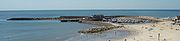
, a place where many fossils may be found. The Cobb at Lyme Regis was the location for The French Lieutenant's Woman (film)
The French Lieutenant's Woman (film)
The French Lieutenant's Woman is a 1981 film directed by Karel Reisz and adapted by playwright Harold Pinter. It is based on the novel of the same title by John Fowles...
in 1981. The South West Coast Path
South West Coast Path
The South West Coast Path is Britain's longest waymarked long-distance footpath and a National Trail. It stretches for , running from Minehead in Somerset, along the coasts of Devon and Cornwall, to Poole Harbour in Dorset. Since it rises and falls with every river mouth, it is also one of the more...
also leads into this part of the town.
Macmillan Way West
The Macmillan Way West is a long distance footpath in Somerset and Devon, England. It runs for from Castle Cary in Somerset to Barnstaple in Devon. It is one of the Macmillan Ways and connects with the main Macmillan Way at Castle Cary....
, River Parrett Trail
River Parrett Trail
The River Parrett Trail is a long-distance footpath, following the route of the River Parrett in Somerset, England. The trail, which is long, runs from Chedington in Dorset to the mouth of the river in Bridgwater Bay where it joins the West Somerset Coast Path....
, Wessex Ridgeway
Wessex Ridgeway
The Wessex Ridgeway is a long distance footpath in England. It runs from Marlborough in Wiltshire to Lyme Regis in Dorset via the edge of Salisbury Plain and Cranborne Chase. The footpath was opened in 1994...
.
Further detail of the Liberty Trail is available from Yeovil Tourist Information Centre and South Somerset Tourist Information.
Way points and maps
Ordnance SurveyOrdnance Survey
Ordnance Survey , an executive agency and non-ministerial government department of the Government of the United Kingdom, is the national mapping agency for Great Britain, producing maps of Great Britain , and one of the world's largest producers of maps.The name reflects its creation together with...
Explorer map series:- 129 - Yeovil & Sherborne (Sherbourne), :-
116 - Lyme Regis & Bridport, provide the geographical details for this trail.
External links
- Geology of Lyme Regis area
- Landslides at Lyme Regis British Geological Survey