

List of cities and towns in Utah
Encyclopedia
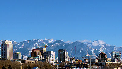
Utah
Utah is a state in the Western United States. It was the 45th state to join the Union, on January 4, 1896. Approximately 80% of Utah's 2,763,885 people live along the Wasatch Front, centering on Salt Lake City. This leaves vast expanses of the state nearly uninhabited, making the population the...
. A municipality is called a town if the population is under 1,000 people, and a city if the population is over 1,000 people. Incorporation means that a municipal charter
Municipal charter
A city charter or town charter is a legal document establishing a municipality such as a city or town. The concept developed in Europe during the middle ages....
has been adopted by the affected population following a referendum. In the Constitution of Utah, cities and towns are granted "the authority to exercise all powers relating to municipal affairs, and to adopt and enforce within its limits, local police, sanitary and similar regulations not in conflict with the general law.". They also have the power to raise and collect taxes, to provide and maintain local public services, acquire by eminent domain
Eminent domain
Eminent domain , compulsory purchase , resumption/compulsory acquisition , or expropriation is an action of the state to seize a citizen's private property, expropriate property, or seize a citizen's rights in property with due monetary compensation, but without the owner's consent...
any property needed to make local improvements, and to raise money by bonds
Bond (finance)
In finance, a bond is a debt security, in which the authorized issuer owes the holders a debt and, depending on the terms of the bond, is obliged to pay interest to use and/or to repay the principal at a later date, termed maturity...
.
On July 22, 1847, the first party of Mormon pioneers arrived in the Salt Lake Valley, where they founded Salt Lake City
Salt Lake City, Utah
Salt Lake City is the capital and the most populous city of the U.S. state of Utah. The name of the city is often shortened to Salt Lake or SLC. With a population of 186,440 as of the 2010 Census, the city lies in the Salt Lake City metropolitan area, which has a total population of 1,124,197...
, the first European settlement in Utah. Over the next 22 years, more than 70,000 pioneers crossed the plains and settled in Utah. Initial colonization along the Wasatch Front
Wasatch Front
The Wasatch Front is a metropolitan region in the north-central part of the U.S. state of Utah. It consists of a chain of cities and towns stretched along the Wasatch Range from approximately Santaquin in the south to Brigham City in the north...
was mostly made by members of The Church of Jesus Christ of Latter-day Saints (LDS Church) with no direct involvement from it. Outside the Wasatch Front, most settlements were directed, planned, organized, and dispatched by leaders of the LDS Church. Settlements were also founded by the railroads, mining companies and non-Mormons. Many settlements were named after leaders, history or from scriptures of the LDS Church. Natural features of the region, including rivers, mountains, lakes and flora, are also commonly used for names.
The 2010 U.S. Census
United States Census
The United States Census is a decennial census mandated by the United States Constitution. The population is enumerated every 10 years and the results are used to allocate Congressional seats , electoral votes, and government program funding. The United States Census Bureau The United States Census...
count puts 2,438,347 of the state's 2,763,885 residents within these cities and towns, accounting for 88.2% of the population. Just over 75% of Utah's population is concentrated in the four Wasatch Front counties of Salt Lake
Salt Lake County, Utah
Salt Lake County is a county located in the U.S. state of Utah. It had a population of 1,029,655 at the 2010 census. Its county seat and largest city is Salt Lake City, the state capital. It occupies Salt Lake Valley, as well as parts of the surrounding mountains, the Oquirrh Mountains to the west...
, Utah
Utah County, Utah
Utah County is a county located in the U.S. state of Utah. As of 2000, the population was 368,536 and by 2008 was estimated at 530,837. It was named for the Spanish name for the Ute Indians. The county seat and largest city is Provo...
, Davis
Davis County, Utah
Davis County is a county located in the U.S. state of Utah. As of 2010 the population was 306,479, a 28.2% increase over the 2000 figure of 238,994. It was named for Daniel C. Davis, captain in the Mormon Battalion. The county is part of the Ogden–Clearfield Metropolitan Statistical Area as...
, and Weber
Weber County, Utah
Weber County is a county located in the U.S. state of Utah, occupying a stretch of the Wasatch Front, part of the eastern shores of Great Salt Lake, and much of the rugged Wasatch Mountains. As of the 2000 census, the population was 196,533, an increase of 24.1% over its population in 1990. By...
. The largest city is the state's capital of Salt Lake City with a population of 186,440, and the former coal mining town of Scofield
Scofield, Utah
Scofield is a town in Carbon County, Utah, United States. The population was 28 at the 2000 census. Scofield's name is frequently applied to the 1900 mine disaster in the Pleasant Valley Coal Company's Winter Quarters mine. The community was named for General Charles W...
is the smallest town with 24 people.
Incorporated cities and towns
| Name |
County |
Population (2010) |
Area (2000) |
Elevation |
Year settled |
Median household income (1999) |
Etymology |
|---|---|---|---|---|---|---|---|
| Alpine Alpine, Utah Alpine is a city in Utah County, Utah, United States. It is part of the Provo–Orem, Utah Metropolitan Statistical Area. The population was 9555 at the 2010 census. Alpine has been one of the many quickly-growing cities of Utah since the 1970s, and especially the 1990s. It is located on the... |
Utah Utah County, Utah Utah County is a county located in the U.S. state of Utah. As of 2000, the population was 368,536 and by 2008 was estimated at 530,837. It was named for the Spanish name for the Ute Indians. The county seat and largest city is Provo... |
9,555 | 4951 feet (1,509.1 m) | 1850 | $72,880 | Adjacent high mountains of the Wasatch Mountains and Traverse Mountains | |
| Alta Alta, Utah Alta is a town in Salt Lake County, Utah, United States. It is part of the Salt Lake City, Utah Metropolitan Statistical Area. The population was 370 at the 2000 census, a slight decrease from the 1990 figure of 397.... |
Salt Lake Salt Lake County, Utah Salt Lake County is a county located in the U.S. state of Utah. It had a population of 1,029,655 at the 2010 census. Its county seat and largest city is Salt Lake City, the state capital. It occupies Salt Lake Valley, as well as parts of the surrounding mountains, the Oquirrh Mountains to the west... |
383 | 8560 feet (2,609.1 m) | 1866 | $51,250 | Spanish Spanish language Spanish , also known as Castilian , is a Romance language in the Ibero-Romance group that evolved from several languages and dialects in central-northern Iberia around the 9th century and gradually spread with the expansion of the Kingdom of Castile into central and southern Iberia during the... word for "high" due to Alta's elevation |
|
| Altamont Altamont, Utah Altamont is a town in Duchesne County, Utah, United States. The population was 178 at the 2000 census, an increase over the 1990 figure of 167.-History:... |
Duchesne Duchesne County, Utah Duchesne County is a county located in the U.S. state of Utah. As of 2010 the population was 18,607, a 29.5% increase over the 2000 figure of 14,371. Its county seat is Duchesne and the largest city is Roosevelt.-Geography:... |
225 | 6388 feet (1,947.1 m) | $28,750 | Composite name of nearby peaks Altonah and Mt. Emmons | ||
| Alton Alton, Utah Alton is a town in Kane County, Utah, United States. The population was 134 at the 2000 census, a modest increase over the 1990 figure of 93.-Geography:Alton is located at .... |
Kane Kane County, Utah As of the census of 2000, there were 6,046 people, 2,237 households, and 1,628 families residing in the county. The population density was 2 people per square mile . There were 3,767 housing units at an average density of 1 per square mile... |
119 | 7041 feet (2,146.1 m) | $30,883 | Alton Fjord in Norway Norway Norway , officially the Kingdom of Norway, is a Nordic unitary constitutional monarchy whose territory comprises the western portion of the Scandinavian Peninsula, Jan Mayen, and the Arctic archipelago of Svalbard and Bouvet Island. Norway has a total area of and a population of about 4.9 million... |
||
| Amalga Amalga, Utah Amalga is a town in Cache County, Utah, United States. The population was 488 at the 2010 census. It is included in the Logan, Utah-Idaho Metropolitan Statistical Area.... |
Cache | 488 | 4439 feet (1,353 m) | 1860 | $42,143 | Amalgamated Sugar Company | |
| American Fork American Fork, Utah American Fork is a city in Utah County, Utah, United States, at the foot of Mount Timpanogos in the Wasatch Range, north of Utah Lake. It is part of the Provo–Orem, Utah Metropolitan Statistical Area. The population was 26,263 at the 2010 census, nearly a 20% growth since the 2000 census... |
Utah Utah County, Utah Utah County is a county located in the U.S. state of Utah. As of 2000, the population was 368,536 and by 2008 was estimated at 530,837. It was named for the Spanish name for the Ute Indians. The county seat and largest city is Provo... |
26,263 | 4606 feet (1,403.9 m) | 1850 | $51,955 | American Fork River, a tributary of Utah Lake Utah Lake Utah Lake is a freshwater lake in the U.S. state of Utah. On the western side of Utah Valley, the lake is overlooked by Mount Timpanogos and Mount Nebo. The lake's only river outlet, the Jordan River, is a tributary of the Great Salt Lake and is highly regulated with pumps. Evaporation accounts... |
|
| Annabella Annabella, Utah Annabella is a town in Sevier County, Utah, United States. The population was 603 at the 2000 census, a modest increase over the 1990 figure of 487.- History :... |
Sevier Sevier County, Utah As of the census of 2000, there were 18,842 people, 6,081 households, and 4,907 families residing in the county. The population density was 10 people per square mile . There were 7,016 housing units at an average density of 4 per square mile... |
795 | 5292 feet (1,613 m) | 1871 | $40,000 | Composite name of Ann S. Roberts and Isabella Dalton, woman settlers of Annabella | |
| Antimony Antimony, Utah Antimony is a town in Garfield County, Utah, United States. The population was 122 at the 2000 census, a small increase over the 1990 population of 83.-Geography:Antimony is located at .... |
Garfield Garfield County, Utah Garfield County is a county located in the U.S. state of Utah. As of 2000 the population was 4,735. It was named for James A. Garfield, President of the United States in 1881. Its county seat and largest city is Panguitch.-Geography:... |
122 | 6453 feet (1,966.9 m) | 1873 | $22,500 | The metal antimony Antimony Antimony is a toxic chemical element with the symbol Sb and an atomic number of 51. A lustrous grey metalloid, it is found in nature mainly as the sulfide mineral stibnite... that was mined in the area |
|
| Apple Valley Apple Valley, Utah Apple Valley is a town in Washington County, Utah, United States, located east of Hurricane along SR-59. The population was 701 at the 2010 census.... |
Washington Washington County, Utah As of the census of 2000, there were 90,354 people, 29,939 households, and 23,442 families residing in the county. The population density was 37 people per square mile . There were 36,478 housing units at an average density of 15 per square mile... |
701 | 4941 feet (1,506 m) | ||||
| Aurora Aurora, Utah Aurora is a city in Sevier County, Utah, United States. The population was 947 at the 2000 census.Aurora is predominantly supported by agriculture, coal mining, and the service sector. Most residents commute to one of the neighboring communities to work. Children are schooled in Salina at one of... |
Sevier Sevier County, Utah As of the census of 2000, there were 18,842 people, 6,081 households, and 4,907 families residing in the county. The population density was 10 people per square mile . There were 7,016 housing units at an average density of 4 per square mile... |
1,016 | 5200 feet (1,585 m) | 1875 | $44,911 | Aurora Aurora (mythology) Aurora is the Latin word for dawn, the goddess of dawn in Roman mythology and Latin poetry.Like Greek Eos and Rigvedic Ushas , Aurora continues the name of an earlier Indo-European dawn goddess, *Hausos.... , the Roman goddess of dawn |
|
| Ballard Ballard, Utah Ballard is a town in Uintah County, Utah, United States. The population was 566 at the 2000 census, a decrease of 78 persons from the 1990 population of 644.-Geography:Ballard is located at .... |
Uintah Uintah County, Utah This page deals with the Utah County. For the Wyoming County, see Uinta County, Wyoming.Uintah County is a county located in the U.S. state of Utah. As of 2000 the population was 25,224 and by 2009 was estimated at 31,536. It was named for the Ute Indians, the tribe that lives in the basin. Its... |
801 | 5049 feet (1,538.9 m) | $35,278 | Melvin J. Ballard Melvin J. Ballard Melvin Joseph Ballard was a member of the Quorum of the Twelve Apostles of The Church of Jesus Christ of Latter-day Saints . He was born in Logan, Utah Territory. His grandson, M. Russell Ballard, was also ordained an apostle.Prior to his birth, his mother had an experience that led her to believe... , a LDS Church Apostle |
||
| Bear River City Bear River City, Utah Bear River City is a city in Box Elder County, Utah, United States. The population was 853 at the 2010 census, an increase over the 1990 population of 700. At the time this was sufficient under Utah state law for Bear River City to become a city, which it did at the end of 2000... |
Box Elder Box Elder County, Utah Box Elder County is a county located in the U.S. state of Utah. It lies on the north end of the Great Salt Lake, covering a large area north to the Idaho border and west to the Nevada border. Included in this area are large tracts of barren desert, contrasted by high, forested mountains. The... |
853 | 4258 feet (1,297.8 m) | 1866 | $52,212 | Bear River Bear River (Utah) The Bear River is a river, approximately long, in southwestern Wyoming, southeastern Idaho, and northern Utah, in the United States. The largest tributary of the Great Salt Lake, it drains a mountainous area and farming valleys northeast of the lake and southeast of the Snake River Plain... , a 350 miles (563.3 km) river and largest tributary of the Great Salt Lake Great Salt Lake The Great Salt Lake, located in the northern part of the U.S. state of Utah, is the largest salt water lake in the western hemisphere, the fourth-largest terminal lake in the world. In an average year the lake covers an area of around , but the lake's size fluctuates substantially due to its... |
|
| Beaver Beaver, Utah Beaver is a city in Beaver County, Utah, United States. The population was 2,454 at the 2000 census. It is the county seat of Beaver County.Settled by Mormon pioneers in 1856, Beaver was one of a string of Mormon settlements extending the length of Utah... * |
Beaver Beaver County, Utah As of the census of 2010, there were 6,629 people, 2,265 households, and 1,697 families residing in the county. The population density was 2.56 people per square mile . There were 2,908 housing units at an average density of 1.12 per square mile... |
3,112 | 5902 feet (1,798.9 m) | 1856 | $33,646 | Beaver River, a 242 miles (389.5 km) river that eventually disappears into the ground | |
| Bicknell Bicknell, Utah Bicknell is a town along State Route 24 in Wayne County, Utah, United States. As of the 2000 census, the town population was 353, a slight increase over the 1990 figure of 327.-History:... |
Wayne Wayne County, Utah Wayne County is a county located in the U.S. state of Utah. It was formed from Piute County in 1892. The county gets its name from a man who served as delegate to the constitutional convention, in honor of his son who was dragged to death by a horse. As of 2000 the population was 2,509, and by... |
327 | 7123 feet (2,171.1 m) | 1879 | $32,750 | Thomas W. Bicknell Thomas W. Bicknell Thomas W. Bicknell , American educator, historian, and author, lived to be 91.Bicknell, born in Barrington, Rhode Island, he was the son of a farmer, minister, state legislator, and Colonel in the Bristol County, Rhode Island Militia, Thomas would become a wealthy eastern historian and educator... , who donated 500 books to the library |
|
| Big Water Big Water, Utah Big Water is a town in Kane County, Utah, United States. The population was 417 at the 2000 census, a modest increase over the 1990 figure of 326. It is located 17 miles north of Page, Arizona on US-89 near Lake Powell and the Glen Canyon Dam. It was originally called Glen Canyon City and housed... |
Kane Kane County, Utah As of the census of 2000, there were 6,046 people, 2,237 households, and 1,628 families residing in the county. The population density was 2 people per square mile . There were 3,767 housing units at an average density of 1 per square mile... |
475 | 4108 feet (1,252.1 m) | 1958 | $30,278 | ||
| Blanding Blanding, Utah Blanding is a city in San Juan County, Utah, United States. The population was 3,162 at the 2000 census, making it the most populated city in San Juan County. It was settled in the late 19th century by Mormon settlers, predominantly from the famed Hole-In-The-Rock expedition... |
San Juan San Juan County, Utah As of the current census of 2010, there were 14,746 people and 4,505 households. The racial and ethnic composition of the population was 50.4% Native American, 45.8% white, 0.3% Asian, 0.2% African American and 2.3% reporting two or more races... |
3,375 | 6106 feet (1,861.1 m) | 1887 | $32,991 | Maiden name of the wife of Thomas W. Bicknell Thomas W. Bicknell Thomas W. Bicknell , American educator, historian, and author, lived to be 91.Bicknell, born in Barrington, Rhode Island, he was the son of a farmer, minister, state legislator, and Colonel in the Bristol County, Rhode Island Militia, Thomas would become a wealthy eastern historian and educator... , who donated 500 books to the library |
|
| Bluffdale Bluffdale, Utah Bluffdale is a city in Salt Lake County, Utah, USA. It is part of the Salt Lake City, Utah Metropolitan Statistical Area. The population was 4,700 according to the 2000 census... |
Salt Lake Salt Lake County, Utah Salt Lake County is a county located in the U.S. state of Utah. It had a population of 1,029,655 at the 2010 census. Its county seat and largest city is Salt Lake City, the state capital. It occupies Salt Lake Valley, as well as parts of the surrounding mountains, the Oquirrh Mountains to the west... |
7,598 | 4436 feet (1,352.1 m) | 1886 | $66,615 | The bluffs along the Jordan River Jordan River (Utah) The Jordan River in the U.S. state of Utah is a river about long. Regulated by pumps at its headwaters at Utah Lake, it flows northward through the Salt Lake Valley and empties into the Great Salt Lake. Four of Utah's five largest cities—Salt Lake City, West Valley City, West Jordan and... |
|
| Boulder Boulder, Utah Boulder is a town in Garfield County, Utah, United States, 27 miles northeast of Escalante on Utah Scenic Byway 12 at its intersection with the Burr Trail... |
Garfield Garfield County, Utah Garfield County is a county located in the U.S. state of Utah. As of 2000 the population was 4,735. It was named for James A. Garfield, President of the United States in 1881. Its county seat and largest city is Panguitch.-Geography:... |
226 | 6703 feet (2,043.1 m) | 1889 | $30,000 | Boulder Mountain Boulder Mountain (Utah) Boulder Mountain in Utah, USA makes up half of the Aquarius Plateau of South Central Utah in Wayne and Garfield counties. The mountain rises to the west of Capitol Reef National Park and consists of steep slopes and cliffs with over 50,000 acres of rolling forest and meadowlands on the top... , a 11317 feet (3,449.4 m) mountain located in the Dixie National Forest Dixie National Forest Dixie National Forest is a United States National Forest in Utah with headquarters in Cedar City. It occupies almost two million acres and stretches for about 170 miles across southern Utah. The largest national forest in Utah, it straddles the divide between the Great Basin and the Colorado River... |
|
| Bountiful Bountiful, Utah Bountiful is a city in Davis County, Utah, United States. As of the 2010 census, the city population was 42,552, a three percent increase over the 2000 figure of 41,301... |
Davis Davis County, Utah Davis County is a county located in the U.S. state of Utah. As of 2010 the population was 306,479, a 28.2% increase over the 2000 figure of 238,994. It was named for Daniel C. Davis, captain in the Mormon Battalion. The county is part of the Ogden–Clearfield Metropolitan Statistical Area as... |
42,552 | 4797 feet (1,462.1 m) | 1847 | $55,993 | The Book of Mormon Book of Mormon The Book of Mormon is a sacred text of the Latter Day Saint movement that adherents believe contains writings of ancient prophets who lived on the American continent from approximately 2600 BC to AD 421. It was first published in March 1830 by Joseph Smith, Jr... city of Bountiful Bountiful (Book of Mormon) Bountiful is the name of two places described in the Book of Mormon, a religious narrative dictated in 1829 by Joseph Smith, Jr. The first location is set in the Old World near Jerusalem, and the second location is set somewhere in the Americas... |
|
| Brian Head Brian Head, Utah Brian Head is a town in Iron County, Utah, United States. The population was 118 at the 2000 census, a small increase over the 1990 figure of 109.Brian Head is also the location of the Brian Head Ski Resort.- History :... |
Iron Iron County, Utah As of the census of 2000, there were 33,779 people, 10,627 households, and 8,076 families residing in the county. The population density was 10 people per square mile . There were 13,618 housing units at an average density of 4 per square mile... |
83 | 9800 feet (2,987 m) | $44,063 | William Jennings Bryan William Jennings Bryan William Jennings Bryan was an American politician in the late-19th and early-20th centuries. He was a dominant force in the liberal wing of the Democratic Party, standing three times as its candidate for President of the United States... , national politician and former candidate for President of the United States President of the United States The President of the United States of America is the head of state and head of government of the United States. The president leads the executive branch of the federal government and is the commander-in-chief of the United States Armed Forces.... |
||
| Brigham City Brigham City, Utah Brigham City is a city in Box Elder County, Utah, United States. The population was 17,899 at the 2010 census. It is the county seat of Box Elder County. It lies on the western slope of the Wellsville Mountains, a branch of the Wasatch Range at the western terminus of Box Elder Canyon... * |
Box Elder Box Elder County, Utah Box Elder County is a county located in the U.S. state of Utah. It lies on the north end of the Great Salt Lake, covering a large area north to the Idaho border and west to the Nevada border. Included in this area are large tracts of barren desert, contrasted by high, forested mountains. The... |
17,899 | 4436 feet (1,352.1 m) | 1850 | $42,335 | Brigham Young Brigham Young Brigham Young was an American leader in the Latter Day Saint movement and a settler of the Western United States. He was the President of The Church of Jesus Christ of Latter-day Saints from 1847 until his death in 1877, he founded Salt Lake City, and he served as the first governor of the Utah... , LDS Church President and first territorial Governor of Utah |
|
| Bryce Canyon City Bryce Canyon City, Utah Bryce Canyon City is a town in Garfield County, Utah, United States, adjacent to Bryce Canyon National Park. The town, formerly known as Ruby's Inn, was officially incorporated on 23 July 2007 under a controversial, short-lived state law... |
Garfield Garfield County, Utah Garfield County is a county located in the U.S. state of Utah. As of 2000 the population was 4,735. It was named for James A. Garfield, President of the United States in 1881. Its county seat and largest city is Panguitch.-Geography:... |
198 | 7664 feet (2,336 m) | 1875 | Local homsteader Ebenezer Bryce Ebenezer Bryce Ebenezer Bryce was a Mormon pioneer, best known as the person for whom Bryce Canyon National Park was named.... |
||
| Cannonville Cannonville, Utah Cannonville is a town in Garfield County, Utah, United States, along Utah Scenic Byway 12. In the 2000 census, the population was 148, a small increase over the 1990 figure of 131.-Geography:Cannonville is located at .... |
Garfield Garfield County, Utah Garfield County is a county located in the U.S. state of Utah. As of 2000 the population was 4,735. It was named for James A. Garfield, President of the United States in 1881. Its county seat and largest city is Panguitch.-Geography:... |
167 | 5886 feet (1,794.1 m) | 1874 | $28,750 | George Q. Cannon George Q. Cannon George Quayle Cannon was an early member of the Quorum of the Twelve Apostles of The Church of Jesus Christ of Latter-day Saints , and served in the First Presidency under four successive presidents of the church: Brigham Young, John Taylor, Wilford Woodruff, and Lorenzo Snow... , a LDS Church Apostle |
|
| Castle Dale Castle Dale, Utah Castle Dale is a city in Emery County, Utah, United States. The population was 1,657 at the 2000 census. It is the county seat of Emery County.-History:... * |
Emery Emery County, Utah Emery County is a county located in the U.S. state of Utah. As of 2000 the population was 10,860, and by 2009 had been estimated to decrease to 10,629. It was named for George W. Emery, governor of the Utah Territory in 1875... |
1,630 | 5676 feet (1,730 m) | 1879 | $44,185 | Located in the Castle Valley, but a Postal Service United States Postal Service The United States Postal Service is an independent agency of the United States government responsible for providing postal service in the United States... mistake listed town as Castle Dale instead of Castle Vale. |
|
| Castle Valley Castle Valley, Utah Castle Valley is a town in Grand County, Utah, United States. The population was 349 at the 2000 census. The town is about 16 miles northeast of Moab near State Route 128.-Geography:Castle Valley is located at .... |
Grand Grand County, Utah Grand County is a county located in the U.S. state of Utah. As of 2000 the population was 8,485, and by 2005 had been estimated at 8,743. It was named for the Colorado River, which at the time of statehood was known as the Grand River. Its county seat and largest city is Moab.-Geography:According... |
319 | 4685 feet (1,428 m) | 1974 | $33,068 | Located in the Castle Valley | |
| Cedar City Cedar City, Utah As of the census of 2000, there were 20,527 people, 6,486 households, and 4,682 families residing in the city. The population density was 1,021.8 people per square mile . There were 7,109 housing units at an average density of 353.9 per square mile... |
Iron Iron County, Utah As of the census of 2000, there were 33,779 people, 10,627 households, and 8,076 families residing in the county. The population density was 10 people per square mile . There were 13,618 housing units at an average density of 4 per square mile... |
28,857 | 5846 feet (1,781.9 m) | 1851 | $32,043 | Large number of cedar trees in the area | |
| Cedar Fort Cedar Fort, Utah Cedar Fort is a town in Utah County, Utah, United States. It is part of the Provo–Orem, Utah Metropolitan Statistical Area. The population was 341 at the 2000 census.-Geography:Cedar Fort is located at .... |
Utah Utah County, Utah Utah County is a county located in the U.S. state of Utah. As of 2000, the population was 368,536 and by 2008 was estimated at 530,837. It was named for the Spanish name for the Ute Indians. The county seat and largest city is Provo... |
368 | 5085 feet (1,549.9 m) | 1856 | $44,773 | Large number of cedar trees in the area | |
| Cedar Hills Cedar Hills, Utah Cedar Hills is a city in Utah County, Utah, United States. The population was 3,094 at the 2000 census, and was estimated to be 9,551 in 2008. The city began growing rapidly during the 1990s, with the largest growth rate of any municipality in the state. It is located east of Alpine and Highland on... |
Utah Utah County, Utah Utah County is a county located in the U.S. state of Utah. As of 2000, the population was 368,536 and by 2008 was estimated at 530,837. It was named for the Spanish name for the Ute Indians. The county seat and largest city is Provo... |
9,796 | 4957 feet (1,510.9 m) | $62,668 | Local cedar tree covered hills | ||
| Centerfield Centerfield, Utah Centerfield is a city in Sanpete County, Utah, United States. The population was 1,048 at the 2000 census. Although Centerfield was a town in 2000, it has since been classified as a fifth-class city by state law.-Geography:... |
Sanpete Sanpete County, Utah Sanpete County is a county located in the U.S. state of Utah. The population according to the 2010 U.S. Census was 27,822. It was possibly named for a Ute Indian chief named Sanpitch, which was corrupted to Sanpete. Its county seat is Manti and its largest city is Ephraim.-Geography:According to... |
1,367 | 5098 feet (1,553.9 m) | 1869 | $35,357 | Center of the Gunnison Valley | |
| Centerville Centerville, Utah Centerville is a city in Davis County, Utah, United States. It is part of the Ogden-Clearfield Metropolitan Statistical Area. The population was 15,335 at the 2010 census... |
Davis Davis County, Utah Davis County is a county located in the U.S. state of Utah. As of 2010 the population was 306,479, a 28.2% increase over the 2000 figure of 238,994. It was named for Daniel C. Davis, captain in the Mormon Battalion. The county is part of the Ogden–Clearfield Metropolitan Statistical Area as... |
15,335 | 4377 feet (1,334.1 m) | 1848 | $64,818 | Center between Farmington Farmington, Utah Farmington is a city in Davis County, Utah, United States. It is part of the Ogden–Clearfield, Utah Metropolitan Statistical Area. The population was 18,255 at the 2010 census. It is the county seat of Davis County... and Bountiful Bountiful, Utah Bountiful is a city in Davis County, Utah, United States. As of the 2010 census, the city population was 42,552, a three percent increase over the 2000 figure of 41,301... |
|
| Central Valley Central Valley, Utah Central Valley is a town in Sevier County, Utah, United States. The population was 415 at the 2008 census estimate.... |
Sevier Sevier County, Utah As of the census of 2000, there were 18,842 people, 6,081 households, and 4,907 families residing in the county. The population density was 10 people per square mile . There were 7,016 housing units at an average density of 4 per square mile... |
528 | 5305 feet (1,617 m) | ||||
| Charleston Charleston, Utah Charleston is a town in Wasatch County, Utah, United States. The population was 378 at the 2000 census.-Geography:Charleston is located at .... |
Wasatch Wasatch County, Utah Wasatch County is a county located in the U.S. state of Utah. It was named for a Ute Indian word meaning mountain pass or low place in the high mountains. Its county seat and largest city is Heber City.The county is governed by a county council with an appointed county manager.Wasatch County is... |
415 | 5440 feet (1,658.1 m) | 1852 | $42,813 | Charles Shelton, who surveyed the town | |
| Circleville Circleville, Utah Circleville is a town in Piute County, Utah, United States. The population was 505 at the 2000 census.-Geography:Circleville is located at .... |
Piute Piute County, Utah Piute County is a county located in the U.S. state of Utah. The population in 2000 was 1,435, and by 2005 had been estimated to decrease to 1,365. It was named for the Paiute tribe of Native Americans. The county seat is Junction and the largest city is Circleville.-Geography:According to the U.S... |
547 | 6066 feet (1,848.9 m) | 1864 | $32,083 | Located in the Circle Valley | |
| Clarkston Clarkston, Utah Clarkston is a town in Cache County, Utah, United States. The population was 666 at the 2010 census. It is included in the Logan, Utah-Idaho Metropolitan Statistical Area.... |
Cache | 666 | 4879 feet (1,487.1 m) | 1864 | $40,592 | Justus Clark, an original settler | |
| Clawson Clawson, Utah Clawson is a town in Emery County, Utah, United States. The population was 153 at the 2000 census.-History:A canal to carry water from Ferron Creek was completed in 1896. Prior to being settled the area was known as North Flat. In 1897, the first settlers arrived, calling the community... |
Emery Emery County, Utah Emery County is a county located in the U.S. state of Utah. As of 2000 the population was 10,860, and by 2009 had been estimated to decrease to 10,629. It was named for George W. Emery, governor of the Utah Territory in 1875... |
163 | 5942 feet (1,811.1 m) | 1897 | $31,250 | Rudger Clawson Rudger Clawson Rudger Judd Clawson was a member of the Quorum of the Twelve Apostles of The Church of Jesus Christ of Latter-day Saints from 1898 until his death in 1943... , a LDS Church Apostle |
|
| Clearfield Clearfield, Utah Clearfield is a city in Davis County, Utah, United States. The population was 25,974 at the 2000 census. The city grew drastically during the 1940s, with the formation of Hill Air Force Base, and in the 1950s with the nation-wide increase in suburb and "bedroom" community populations and has been... |
Davis Davis County, Utah Davis County is a county located in the U.S. state of Utah. As of 2010 the population was 306,479, a 28.2% increase over the 2000 figure of 238,994. It was named for Daniel C. Davis, captain in the Mormon Battalion. The county is part of the Ogden–Clearfield Metropolitan Statistical Area as... |
30,112 | 4465 feet (1,360.9 m) | 1877 | $38,946 | The open surroundings of the area | |
| Cleveland Cleveland, Utah Cleveland is a town in Emery County, Utah, in the United States. As of the 2000 census, the town population was 508.-Geography:Cleveland is located at .... |
Emery Emery County, Utah Emery County is a county located in the U.S. state of Utah. As of 2000 the population was 10,860, and by 2009 had been estimated to decrease to 10,629. It was named for George W. Emery, governor of the Utah Territory in 1875... |
464 | 5722 feet (1,744.1 m) | 1885 | $33,500 | Grover Cleveland Grover Cleveland Stephen Grover Cleveland was the 22nd and 24th president of the United States. Cleveland is the only president to serve two non-consecutive terms and therefore is the only individual to be counted twice in the numbering of the presidents... , President of the United States President of the United States The President of the United States of America is the head of state and head of government of the United States. The president leads the executive branch of the federal government and is the commander-in-chief of the United States Armed Forces.... |
|
| Clinton Clinton, Utah Clinton is a city in Davis County, Utah, United States. It is part of the Ogden–Clearfield, Utah Metropolitan Statistical Area. The population was 12,585 at the 2000 census, while the 2008 estimates placed it at 19,855... |
Davis Davis County, Utah Davis County is a county located in the U.S. state of Utah. As of 2010 the population was 306,479, a 28.2% increase over the 2000 figure of 238,994. It was named for Daniel C. Davis, captain in the Mormon Battalion. The county is part of the Ogden–Clearfield Metropolitan Statistical Area as... |
20,426 | 4393 feet (1,339 m) | 1870s | $53,909 | ||
| Coalville Coalville, Utah Coalville is a city in Summit County, Utah, United States. It is part of the Salt Lake City, Utah Metropolitan Statistical Area. The population was 1,382 at the 2000 census. It is the county seat of Summit County... * |
Summit Summit County, Utah Summit County is a county located in the U.S. state of Utah, occupying a rugged and mountainous area. In 2010 its population was 36,324. It is part of the Salt Lake City Metropolitan Statistical Area as well as the Salt Lake City–Ogden–Clearfield Combined Statistical Area. The county is... |
1,363 | 5577 feet (1,699.9 m) | 1858 | $39,342 | Many of the miners came from Coalville Coalville Coalville is a town in North West Leicestershire, England, with a population estimated in 2003 to be almost 33,000. It is situated on the A511 trunk road between Leicester and Burton upon Trent, close to junction 22 of the M1 motorway where the A511 meets the A50 between Ashby-de-la-Zouch and... , England England England is a country that is part of the United Kingdom. It shares land borders with Scotland to the north and Wales to the west; the Irish Sea is to the north west, the Celtic Sea to the south west, with the North Sea to the east and the English Channel to the south separating it from continental... |
|
| Corinne Corinne, Utah Corinne is a city in Box Elder County, Utah, United States. The population was 685 at the 2010 census.-Geography:Corinne is located at .... |
Box Elder Box Elder County, Utah Box Elder County is a county located in the U.S. state of Utah. It lies on the north end of the Great Salt Lake, covering a large area north to the Idaho border and west to the Nevada border. Included in this area are large tracts of barren desert, contrasted by high, forested mountains. The... |
685 | 4226 feet (1,288.1 m) | 1869 | $42,125 | Corinne, the first child born in the area | |
| Cornish Cornish, Utah Cornish is a town in Cache County, Utah, United States. The population was 288 at the 2010 census. It is included in the Logan, Utah-Idaho Metropolitan Statistical Area.-Geography:Cornish is located at .... |
Cache | 288 | 4485 feet (1,367 m) | $40,417 | William D Cornish, vice-president of the Union Pacific Railroad Union Pacific Railroad The Union Pacific Railroad , headquartered in Omaha, Nebraska, is the largest railroad network in the United States. James R. Young is president, CEO and Chairman.... |
||
| Cottonwood Heights Cottonwood Heights, Utah Cottonwood Heights is a city located in Salt Lake County, Utah, United States, along the east bench of the Salt Lake Valley. It lies south of the cities of Holladay and Murray, east of Midvale, and north of Sandy within the Salt Lake City, Utah Metropolitan Statistical Area. Following a successful... |
Salt Lake Salt Lake County, Utah Salt Lake County is a county located in the U.S. state of Utah. It had a population of 1,029,655 at the 2010 census. Its county seat and largest city is Salt Lake City, the state capital. It occupies Salt Lake Valley, as well as parts of the surrounding mountains, the Oquirrh Mountains to the west... |
33,433 | 4823 feet (1,470.1 m) | 1848 | Cottonwood trees found in the area | ||
| Daniel Daniel, Utah Daniel is a town in Wasatch County, Utah, United States. The population was 770 at the 2000 census, at which time it was a census-designated place . Daniel incorporated as a town in February 2006... |
Wasatch Wasatch County, Utah Wasatch County is a county located in the U.S. state of Utah. It was named for a Ute Indian word meaning mountain pass or low place in the high mountains. Its county seat and largest city is Heber City.The county is governed by a county council with an appointed county manager.Wasatch County is... |
938 | 5715 feet (1,741.9 m) | 1874 | Aaron Daniels, one of the first settlers | ||
| Delta Delta, Utah Delta is a city in Millard County, Utah, United States. The population was 3,209 at the 2000 census.-Geography:Delta is located at .... |
Millard Millard County, Utah Millard County is a county located in the U.S. state of Utah. In 2010, its population was 12,420. It was named for Millard Fillmore, thirteenth President of the United States. Its county seat is Fillmore and the largest city is Delta.-Geography:... |
3,436 | 4639 feet (1,414 m) | 1906 | $37,773 | The river delta River delta A delta is a landform that is formed at the mouth of a river where that river flows into an ocean, sea, estuary, lake, reservoir, flat arid area, or another river. Deltas are formed from the deposition of the sediment carried by the river as the flow leaves the mouth of the river... of the Sevier River Sevier River The Sevier River , extending , is the longest Utah river entirely in the state and drains an extended chain of mountain farming valleys to the intermittent Sevier Lake... |
|
| Deweyville Deweyville, Utah Deweyville is a town in Box Elder County, Utah, United States. The population was 332 at the 2010 census.-Geography:Deweyville is located at .... |
Box Elder Box Elder County, Utah Box Elder County is a county located in the U.S. state of Utah. It lies on the north end of the Great Salt Lake, covering a large area north to the Idaho border and west to the Nevada border. Included in this area are large tracts of barren desert, contrasted by high, forested mountains. The... |
332 | 4437 feet (1,352.4 m) | 1864 | $43,750 | John C. Dewey, an early settler to the area | |
| Draper Draper, Utah Draper is a city in Salt Lake and Utah Counties in the U.S. state of Utah, located about south of Salt Lake City along the Wasatch Front. Between 1990 and 2000 Draper was Utah's fastest-growing city over 5,000 people . Its population in 1990 was 7,143 and had grown to 25,220 by the 2000 census... |
Salt Lake Salt Lake County, Utah Salt Lake County is a county located in the U.S. state of Utah. It had a population of 1,029,655 at the 2010 census. Its county seat and largest city is Salt Lake City, the state capital. It occupies Salt Lake Valley, as well as parts of the surrounding mountains, the Oquirrh Mountains to the west... / Utah Utah County, Utah Utah County is a county located in the U.S. state of Utah. As of 2000, the population was 368,536 and by 2008 was estimated at 530,837. It was named for the Spanish name for the Ute Indians. The county seat and largest city is Provo... |
42,274 | 4505 feet (1,373.1 m) | 1849 | $72,341 | William Draper, the town's first LDS Church Bishop | |
| Duchesne Duchesne, Utah Duchesne is a city in and the county seat of Duchesne County, Utah, United States. The population was 1,690 at the 2010 census.-Geography:Duchesne city is located at . just west of the junction of the Strawberry and Duchesne rivers in the Uintah Basin of northeastern Utah... * |
Duchesne Duchesne County, Utah Duchesne County is a county located in the U.S. state of Utah. As of 2010 the population was 18,607, a 29.5% increase over the 2000 figure of 14,371. Its county seat is Duchesne and the largest city is Roosevelt.-Geography:... |
1,690 | 5518 feet (1,681.9 m) | 1904 | $32,426 | Nearby Fort Duchesne | |
| Eagle Mountain Eagle Mountain, Utah Eagle Mountain is a city in Utah County, Utah, United States. It is part of the Provo–Orem, Utah Metropolitan Statistical Area. The city is located to the west of the Lake Mountains, which are west of Utah Lake. It was incorporated December 3, 1996 and has been rapidly growing ever since. The... |
Utah Utah County, Utah Utah County is a county located in the U.S. state of Utah. As of 2000, the population was 368,536 and by 2008 was estimated at 530,837. It was named for the Spanish name for the Ute Indians. The county seat and largest city is Provo... |
21,415 | 4882 feet (1,488 m) | $52,102 | Eagle Mountain Properties, the development company of the city | ||
| East Carbon East Carbon, Utah East Carbon is a city in Carbon County, Utah, United States. The population was 1,393 at the 2000 census. East Carbon was incorporated on July 23, 1973, from the merger of the two struggling mining towns of Dragerton and Columbia.-Geography:... |
Carbon Carbon County, Utah Carbon County is a county located in the U.S. state of Utah. Named for the major coal deposits in the area, the county seat and largest city, is Price. Carbon County is the second largest natural gas producer in Utah , with 94 billion cubic feet produced in 2008. As of 2010 the population was... |
1,301 | 4987 feet (1,520 m) | 1922 | $25,313 | Coal deposits found in the area | |
| Elk Ridge Elk Ridge, Utah Elk Ridge is a city in Utah County, Utah, United States. Named for a herd of elk that wintered in the area, it is part of the Provo–Orem, Utah Metropolitan Statistical Area. The population was 1,838 at the 2000 census... |
Utah Utah County, Utah Utah County is a county located in the U.S. state of Utah. As of 2000, the population was 368,536 and by 2008 was estimated at 530,837. It was named for the Spanish name for the Ute Indians. The county seat and largest city is Provo... |
2,436 | 5354 feet (1,631.9 m) | $65,511 | |||
| Elmo Elmo, Utah Elmo is a town in Emery County, Utah, United States. The population was 368 at the 2000 census.-Geography:Elmo is located at .... |
Emery Emery County, Utah Emery County is a county located in the U.S. state of Utah. As of 2000 the population was 10,860, and by 2009 had been estimated to decrease to 10,629. It was named for George W. Emery, governor of the Utah Territory in 1875... |
418 | 5692 feet (1,734.9 m) | 1908 | $33,750 | St. Elmo, an 1866 novel by the author Augusta Jane Evans Augusta Jane Evans Augusta Jane Wilson, or Augusta Evans Wilson, was an American Southern author and one of the pillars of Southern literature. She wrote nine novels: Inez , Beulah , Macaria , St. Elmo , Vashti , Infelice , At the Mercy of Tiberius , A Speckled Bird , and Devota... |
|
| Elsinore Elsinore, Utah Elsinore is a town in Sevier County, Utah, United States. The population was 733 at the 2000 census.-History:The community was first settled in the spring of 1874 by James C. Jensen, Jens Iver Jensen, and others. The area was settled by Danish converts to Mormonism, and named after Kronborg... |
Sevier Sevier County, Utah As of the census of 2000, there were 18,842 people, 6,081 households, and 4,907 families residing in the county. The population density was 10 people per square mile . There were 7,016 housing units at an average density of 4 per square mile... |
847 | 5351 feet (1,631 m) | 1874 | $27,917 | Elsinore Elsinore Helsingør is a city and the municipal seat of Helsingør municipality on the northeast coast of the island of Zealand in eastern Denmark. Helsingør has a population of 46,279 including the southern suburbs of Snekkersten and Espergærde... , Denmark Denmark Denmark is a Scandinavian country in Northern Europe. The countries of Denmark and Greenland, as well as the Faroe Islands, constitute the Kingdom of Denmark . It is the southernmost of the Nordic countries, southwest of Sweden and south of Norway, and bordered to the south by Germany. Denmark... |
|
| Elwood Elwood, Utah Elwood is a town in Box Elder County, Utah, United States. The population was 1,034 at the 2010 census.-Geography:Elwood is located at .... |
Box Elder Box Elder County, Utah Box Elder County is a county located in the U.S. state of Utah. It lies on the north end of the Great Salt Lake, covering a large area north to the Idaho border and west to the Nevada border. Included in this area are large tracts of barren desert, contrasted by high, forested mountains. The... |
1,034 | 4298 feet (1,310 m) | 1879 | $46,406 | Postal Service United States Postal Service The United States Postal Service is an independent agency of the United States government responsible for providing postal service in the United States... named the town |
|
| Emery Emery, Utah Emery is a town in Emery County, Utah, United States. The population was 308 at the 2000 census.-Prehistoric:Emery sits at the base of the mountains that contain the North Horn Formation. Named after North Horn Mountain, near Castle Dale, Utah this formation in Emery County contain numerous... |
Emery Emery County, Utah Emery County is a county located in the U.S. state of Utah. As of 2000 the population was 10,860, and by 2009 had been estimated to decrease to 10,629. It was named for George W. Emery, governor of the Utah Territory in 1875... |
288 | 6253 feet (1,905.9 m) | 1881 | $40,469 | George W. Emery George W. Emery George W. Emery was the eleventh governor of Utah Territory. Emery was appointed by President Ulysses S. Grant for Supervisor of Internal Revenue for the confederate states from 1870 to 1874 and governor in 1875. After his term ended in 1880, the Utah Legislature named Emery County, Utah in... , territorial Governor of Utah |
|
| Enoch Enoch, Utah Enoch is a mostly rural and agricultural city in Iron County, Utah, United States, and is located approximately 6 miles northeast of Cedar City. The population was 5,803 at the 2010 census.... |
Iron Iron County, Utah As of the census of 2000, there were 33,779 people, 10,627 households, and 8,076 families residing in the county. The population density was 10 people per square mile . There were 13,618 housing units at an average density of 4 per square mile... |
5,803 | 5545 feet (1,690.1 m) | 1851 | $37,368 | Enoch, a biblical figure in the Old Testament Old Testament The Old Testament, of which Christians hold different views, is a Christian term for the religious writings of ancient Israel held sacred and inspired by Christians which overlaps with the 24-book canon of the Masoretic Text of Judaism... |
|
| Enterprise Enterprise, Utah Enterprise is a city in Washington County, Utah, United States. The population was 1,711 at the 2010 census. Enterprise is home to two schools, Enterprise Elementary School and Enterprise High School .-Geography:... |
Washington Washington County, Utah As of the census of 2000, there were 90,354 people, 29,939 households, and 23,442 families residing in the county. The population density was 37 people per square mile . There were 36,478 housing units at an average density of 15 per square mile... |
1,711 | 5318 feet (1,620.9 m) | 1902 | $35,694 | Name reflected the first settlers' ability to adjust to problem experienced by the first settlers | |
| Ephraim Ephraim, Utah Ephraim is a city in Sanpete County, Utah, United States. The population was 6,135 at the 2010 census, making it the largest city in Sanpete County. It is the location of Snow College and is located along U.S. Route 89.-History:Ephraim was founded in 1854... |
Sanpete Sanpete County, Utah Sanpete County is a county located in the U.S. state of Utah. The population according to the 2010 U.S. Census was 27,822. It was possibly named for a Ute Indian chief named Sanpitch, which was corrupted to Sanpete. Its county seat is Manti and its largest city is Ephraim.-Geography:According to... |
6,135 | 5541 feet (1,688.9 m) | 1854 | $28,318 | Tribe of Ephraim Tribe of Ephraim According to the Hebrew Bible, the Tribe of Ephraim was one of the Tribes of Israel. The Tribe of Manasseh together with Ephraim also formed the House of Joseph.... , one of the twelve Tribes of Israel. |
|
| Escalante Escalante, Utah Escalante is a city in Garfield County, Utah, United States, along Utah Scenic Byway 12. As of the 2000 census, the city population was 818.The town was named after Silvestre Vélez de Escalante, a Franciscan missionary and the first European explorer in the region... |
Garfield Garfield County, Utah Garfield County is a county located in the U.S. state of Utah. As of 2000 the population was 4,735. It was named for James A. Garfield, President of the United States in 1881. Its county seat and largest city is Panguitch.-Geography:... |
797 | 5820 feet (1,773.9 m) | 1876 | $32,143 | Silvestre Vélez de Escalante, a Franciscan Franciscan Most Franciscans are members of Roman Catholic religious orders founded by Saint Francis of Assisi. Besides Roman Catholic communities, there are also Old Catholic, Anglican, Lutheran, ecumenical and Non-denominational Franciscan communities.... missionary Missionary A missionary is a member of a religious group sent into an area to do evangelism or ministries of service, such as education, literacy, social justice, health care and economic development. The word "mission" originates from 1598 when the Jesuits sent members abroad, derived from the Latin... who explored the area in 1776 |
|
| Eureka Eureka, Utah Eureka was originally known as Ruby Hollow before it developed into a bustling mining town. Incorporated as a city in 1892, Eureka became the financial center for the Tintic Mining District, a wealthy gold and silver mining area in Utah and Juab counties. The district was organized in 1869 and by... |
Juab Juab County, Utah Juab County is a county located in the U.S. state of Utah. As of 2000 the population was 8,238, and by 2005 had been estimated at 9,113. It was named from an Indian word meaning thirsty valley, or possibly only valley. Its county seat and largest city is Nephi.Juab County is part of the... |
669 | 6430 feet (1,959.9 m) | 1869 | $36,875 | Eureka Eureka (word) "Eureka" is an interjection used to celebrate a discovery, a transliteration of a word attributed to Archimedes.-Etymology:The word comes from ancient Greek εὕρηκα heúrēka "I have found ", which is the 1st person singular perfect indicative active of the verb heuriskō "I find"... is the ancient Greek Ancient Greek Ancient Greek is the stage of the Greek language in the periods spanning the times c. 9th–6th centuries BC, , c. 5th–4th centuries BC , and the c. 3rd century BC – 6th century AD of ancient Greece and the ancient world; being predated in the 2nd millennium BC by Mycenaean Greek... name for "I have found it", relating to the gold mines found in the area |
|
| Fairfield Fairfield, Utah Fairfield is a town located in Utah County, Utah, United States. It is part of the Provo–Orem, Utah Metropolitan Statistical Area. The latitude of... |
Utah Utah County, Utah Utah County is a county located in the U.S. state of Utah. As of 2000, the population was 368,536 and by 2008 was estimated at 530,837. It was named for the Spanish name for the Ute Indians. The county seat and largest city is Provo... |
119 | 4877 feet (1,486.5 m) | 1855 | Amos Fielding, an early settler of the area | ||
| Fairview Fairview, Utah Fairview is a city in Sanpete County, Utah, United States. The population was 1,160 at the 2000 census.-History:Located at the confluence of the San Pitch River and Cottonwood Creek, Fairview is the largest town in the northeast end of the Sanpete Valley... |
Sanpete Sanpete County, Utah Sanpete County is a county located in the U.S. state of Utah. The population according to the 2010 U.S. Census was 27,822. It was possibly named for a Ute Indian chief named Sanpitch, which was corrupted to Sanpete. Its county seat is Manti and its largest city is Ephraim.-Geography:According to... |
1,247 | 6948 feet (2,117.8 m) | 1859 | $34,946 | The attractive surroundings of the area | |
| Farmington Farmington, Utah Farmington is a city in Davis County, Utah, United States. It is part of the Ogden–Clearfield, Utah Metropolitan Statistical Area. The population was 18,255 at the 2010 census. It is the county seat of Davis County... * |
Davis Davis County, Utah Davis County is a county located in the U.S. state of Utah. As of 2010 the population was 306,479, a 28.2% increase over the 2000 figure of 238,994. It was named for Daniel C. Davis, captain in the Mormon Battalion. The county is part of the Ogden–Clearfield Metropolitan Statistical Area as... |
18,275 | 4304 feet (1,311.9 m) | 1847 | $74,250 | The farm Farm A farm is an area of land, or, for aquaculture, lake, river or sea, including various structures, devoted primarily to the practice of producing and managing food , fibres and, increasingly, fuel. It is the basic production facility in food production. Farms may be owned and operated by a single... s found in the area |
|
| Farr West Farr West, Utah Farr West is a city in Weber County, Utah, United States. The population was 3,094 at the 2000 census. It is part of the Ogden–Clearfield, Utah Metropolitan Statistical Area.-Geography:Farr West is located at .... |
Weber Weber County, Utah Weber County is a county located in the U.S. state of Utah, occupying a stretch of the Wasatch Front, part of the eastern shores of Great Salt Lake, and much of the rugged Wasatch Mountains. As of the 2000 census, the population was 196,533, an increase of 24.1% over its population in 1990. By... |
5,928 | 4265 feet (1,300 m) | 1858 | $41,618 | Located west of Farr's Fort which was named after Lorin Farr, an early LDS Church stake president of the area. | |
| Fayette Fayette, Utah Fayette is a town in Sanpete County, Utah, United States. The population was 204 at the 2000 census.-Geography:Fayette is located at .... |
Sanpete Sanpete County, Utah Sanpete County is a county located in the U.S. state of Utah. The population according to the 2010 U.S. Census was 27,822. It was possibly named for a Ute Indian chief named Sanpitch, which was corrupted to Sanpete. Its county seat is Manti and its largest city is Ephraim.-Geography:According to... |
242 | 5052 feet (1,539.8 m) | 1861 | $28,750 | Fayette Fayette, New York Fayette is a town in Seneca County, New York, United States. The population was 3,643 at the 2000 census.The Town of Fayette is on the western border of the county and is southeast of Geneva, New York.- History :... , New York New York New York is a state in the Northeastern region of the United States. It is the nation's third most populous state. New York is bordered by New Jersey and Pennsylvania to the south, and by Connecticut, Massachusetts and Vermont to the east... , where the LDS Church was organized |
|
| Ferron Ferron, Utah Ferron is a city in Emery County, Utah, United States. The population was 1,623 at the 2000 census.-Geography:Ferron is located at .... |
Emery Emery County, Utah Emery County is a county located in the U.S. state of Utah. As of 2000 the population was 10,860, and by 2009 had been estimated to decrease to 10,629. It was named for George W. Emery, governor of the Utah Territory in 1875... |
1,626 | 5971 feet (1,820 m) | 1877 | $38,625 | A. D. Ferron, surveyor of the area | |
| Fielding Fielding, Utah Fielding is a town in Box Elder County, Utah, United States. The population was 455 at the 2010 census.-Geography:Fielding is located at .... |
Box Elder Box Elder County, Utah Box Elder County is a county located in the U.S. state of Utah. It lies on the north end of the Great Salt Lake, covering a large area north to the Idaho border and west to the Nevada border. Included in this area are large tracts of barren desert, contrasted by high, forested mountains. The... |
455 | 4373 feet (1,332.9 m) | 1892 | $44,000 | Mother of LDS Church President Joseph Fielding Smith Joseph F. Smith Joseph Fielding Smith, Sr. was the sixth president of The Church of Jesus Christ of Latter-day Saints... |
|
| Fillmore Fillmore, Utah Fillmore is a city in Millard County, Utah, United States. The population was 2,253 at the 2000 census. It is the county seat of Millard County. It is named for the thirteenth US President Millard Fillmore.... * |
Millard Millard County, Utah Millard County is a county located in the U.S. state of Utah. In 2010, its population was 12,420. It was named for Millard Fillmore, thirteenth President of the United States. Its county seat is Fillmore and the largest city is Delta.-Geography:... |
2,435 | 5135 feet (1,565.1 m) | 1851 | $31,719 | Millard Fillmore Millard Fillmore Millard Fillmore was the 13th President of the United States and the last member of the Whig Party to hold the office of president... , President of the United States President of the United States The President of the United States of America is the head of state and head of government of the United States. The president leads the executive branch of the federal government and is the commander-in-chief of the United States Armed Forces.... |
|
| Fountain Green Fountain Green, Utah Fountain Green is a city in Sanpete County, Utah, United States. The population was 945 at the 2000 census.-Geography:Fountain Green is located at .... |
Sanpete Sanpete County, Utah Sanpete County is a county located in the U.S. state of Utah. The population according to the 2010 U.S. Census was 27,822. It was possibly named for a Ute Indian chief named Sanpitch, which was corrupted to Sanpete. Its county seat is Manti and its largest city is Ephraim.-Geography:According to... |
1,071 | 5899 feet (1,798 m) | 1850 | $36,078 | Lush meadows surrounding the area's springs | |
| Francis Francis, Utah Francis is a town in Summit County, Utah, United States. It is part of the Salt Lake City, Utah Metropolitan Statistical Area. The population was 698 at the 2000 census.-Geography:Francis is located at .... |
Summit Summit County, Utah Summit County is a county located in the U.S. state of Utah, occupying a rugged and mountainous area. In 2010 its population was 36,324. It is part of the Salt Lake City Metropolitan Statistical Area as well as the Salt Lake City–Ogden–Clearfield Combined Statistical Area. The county is... |
1,077 | 6562 feet (2,000.1 m) | 1869 | $55,536 | Francis M. Lyman Francis M. Lyman Francis Marion Lyman was a member of the Quorum of the Twelve Apostles of The Church of Jesus Christ of Latter-day Saints . He was the President of the Quorum from 1903 until his death.... , a LDS Church Apostle |
|
| Fruit Heights Fruit Heights, Utah Fruit Heights is a city in Davis County, Utah, United States. It is part of the Ogden–Clearfield, Utah Metropolitan Statistical Area. One of the suburbs of Farmington and Kaysville, its population was 4,701 at the 2000 census. In 2000, Fruit Heights was the 63rd-largest incorporated place in... |
Davis Davis County, Utah Davis County is a county located in the U.S. state of Utah. As of 2010 the population was 306,479, a 28.2% increase over the 2000 figure of 238,994. It was named for Daniel C. Davis, captain in the Mormon Battalion. The county is part of the Ogden–Clearfield Metropolitan Statistical Area as... |
4,987 | 4698 feet (1,432 m) | 1850 | $79,192 | Fruit orchards located above the valley floor | |
| Garden City Garden City, Utah Garden City is a town in Rich County, Utah, United States. The population was 562 at the 2010 census. Garden City sits on the shores of Bear Lake and is a popular summer resort destination town.-History:... |
Rich Rich County, Utah Rich County is a county located in the U.S. state of Utah. The southern half of Bear Lake and the Bear Lake Valley lie on the northern edge of the county. The Bear River Valley lies in most of the eastern portion of the county. The elevation of these valleys is close to , and the rest of the county... |
562 | 5968 feet (1,819 m) | 1877 | $40,750 | Site was considered the garden spot of the valley | |
| Garland Garland, Utah Garland is a city in Box Elder County, Utah, United States. The population was 2,400 at the 2010 census.-History:Garland was originally named Sunset and settled in 1890. The first settler was David E. Manning.... |
Box Elder Box Elder County, Utah Box Elder County is a county located in the U.S. state of Utah. It lies on the north end of the Great Salt Lake, covering a large area north to the Idaho border and west to the Nevada border. Included in this area are large tracts of barren desert, contrasted by high, forested mountains. The... |
2,400 | 4340 feet (1,322.8 m) | 1890 | $38,679 | William Garland, led the construction of a canal in the area | |
| Genola Genola, Utah Genola is a town in Utah County, Utah, United States. It is part of the Provo–Orem, Utah Metropolitan Statistical Area. The population was 965 at the 2000 census.-Geography:... |
Utah Utah County, Utah Utah County is a county located in the U.S. state of Utah. As of 2000, the population was 368,536 and by 2008 was estimated at 530,837. It was named for the Spanish name for the Ute Indians. The county seat and largest city is Provo... |
1,370 | 4600 feet (1,402.1 m) | $45,417 | |||
| Glendale Glendale, Utah Glendale is a town in Kane County, Utah, United States. The population was 355 at the 2000 census. It was founded in 1862 by Mormon pioneers John and William Berry, abandoned in 1866 due to Indian attacks, and resettled in 1871.-Geography:... |
Kane Kane County, Utah As of the census of 2000, there were 6,046 people, 2,237 households, and 1,628 families residing in the county. The population density was 2 people per square mile . There were 3,767 housing units at an average density of 1 per square mile... |
381 | 5778 feet (1,761.1 m) | 1862 | $35,938 | The place being in a glen or a narrow valley with mountains all around | |
| Glenwood Glenwood, Utah Glenwood is a town in Sevier County, Utah, United States. The population was 437 at the 2000 census.- History :Glenwood was established in 1863 by Mormon pioneers. It was named for an early pioneer, Robert Wilson Glenn... |
Sevier Sevier County, Utah As of the census of 2000, there were 18,842 people, 6,081 households, and 4,907 families residing in the county. The population density was 10 people per square mile . There were 7,016 housing units at an average density of 4 per square mile... |
464 | 5272 feet (1,606.9 m) | 1863 | $45,192 | Robert Wilson Glenn, an early settler of the area | |
| Goshen Goshen, Utah Goshen is a town in Utah County, Utah, United States. It is part of the Provo–Orem, Utah Metropolitan Statistical Area. The population was 874 at the 2000 census.-Geography:Goshen is located at .... |
Utah Utah County, Utah Utah County is a county located in the U.S. state of Utah. As of 2000, the population was 368,536 and by 2008 was estimated at 530,837. It was named for the Spanish name for the Ute Indians. The county seat and largest city is Provo... |
921 | 4551 feet (1,387.1 m) | 1857 | $41,458 | Goshen Goshen, Connecticut Goshen is a town in Litchfield County, Connecticut, United States. The population was 2,697 at the 2000 census.Each July, the Connecticut Agricultural Fair is held in town. It is also home to the Goshen players.-Geography:... , Connecticut Connecticut Connecticut is a state in the New England region of the northeastern United States. It is bordered by Rhode Island to the east, Massachusetts to the north, and the state of New York to the west and the south .Connecticut is named for the Connecticut River, the major U.S. river that approximately... , birthplace of Phineas W. Cooke, the first LDS Bishop of the area |
|
| Grantsville Grantsville, Utah Grantsville is the second most populous city in Tooele County, Utah, United States. It is part of the Salt Lake City, Utah Metropolitan Statistical Area. The population was 6,015 at the 2000 census. The city has grown slowly and steadily throughout most of its existence, but rapid increases in... |
Tooele Tooele County, Utah Tooele County is a county located in the U.S. state of Utah. As of 2000, the population was 40,735 and by 2005 was estimated at 51,311. Its county seat and largest city is Tooele.... |
8,893 | 4304 feet (1,311.9 m) | 1850 | $45,614 | Colonel George D. Grant of the Nauvoo Legion Nauvoo Legion The Nauvoo Legion was a militia originally organized by the Latter Day Saints to defend the city of Nauvoo, Illinois, . To curry political favor with the ambiguously-political Saints, the Illinois state legislature granted Nauvoo a liberal city charter that gave the Nauvoo Legion extraordinary... |
|
| Green River Green River, Utah Green River is a city in Emery County, Utah, United States. The population was 973 at the 2000 census.-Geography:Green River is located at , on the banks of the Green River, after which the city is named. The San Rafael Swell region is to the west of Green River, while Canyonlands National Park... |
Emery Emery County, Utah Emery County is a county located in the U.S. state of Utah. As of 2000 the population was 10,860, and by 2009 had been estimated to decrease to 10,629. It was named for George W. Emery, governor of the Utah Territory in 1875... |
952 | 4078 feet (1,243 m) | $28,000 | The Green River Green River (Utah) The Green River, located in the western United States, is the chief tributary of the Colorado River. The watershed of the river, known as the Green River Basin, covers parts of Wyoming, Utah, and Colorado. The Green River is long, beginning in the Wind River Mountains of Wyoming and flowing... , a 730 miles (1,174.8 km) tributary of the Colorado River Colorado River The Colorado River , is a river in the Southwestern United States and northwestern Mexico, approximately long, draining a part of the arid regions on the western slope of the Rocky Mountains. The watershed of the Colorado River covers in parts of seven U.S. states and two Mexican states... |
||
| Gunnison Gunnison, Utah Gunnison is a city in Sanpete County, Utah, United States. The population was 2,394 at the 2000 census. The city was named in honor of John W. Gunnison, a United States Army officer who surveyed for the transcontinental railroad in 1853.-Geography:... |
Sanpete Sanpete County, Utah Sanpete County is a county located in the U.S. state of Utah. The population according to the 2010 U.S. Census was 27,822. It was possibly named for a Ute Indian chief named Sanpitch, which was corrupted to Sanpete. Its county seat is Manti and its largest city is Ephraim.-Geography:According to... |
3,285 | 5138 feet (1,566.1 m) | 1859 | $33,147 | Captain John W. Gunnison John W. Gunnison John Williams Gunnison was an American military officer and explorer.-Biography:Gunnison was born in Goshen, New Hampshire in 1812. He graduated from West Point in 1837, second in his class of fifty cadets. His military career began in Florida, where he spent a year in the campaign against the... , explored and surveyed Great Salt Lake Great Salt Lake The Great Salt Lake, located in the northern part of the U.S. state of Utah, is the largest salt water lake in the western hemisphere, the fourth-largest terminal lake in the world. In an average year the lake covers an area of around , but the lake's size fluctuates substantially due to its... , Utah Lake Utah Lake Utah Lake is a freshwater lake in the U.S. state of Utah. On the western side of Utah Valley, the lake is overlooked by Mount Timpanogos and Mount Nebo. The lake's only river outlet, the Jordan River, is a tributary of the Great Salt Lake and is highly regulated with pumps. Evaporation accounts... and the Salt Lake Valley Salt Lake Valley Salt Lake Valley is a valley in Salt Lake County in the north-central portion of the U.S. state of Utah. It contains Salt Lake City and many of its suburbs, notably West Valley City, Murray, Sandy, and West Jordan; its total population is 1,029,655 as of 2010... for the Corps of Topographical Engineers |
|
| Hanksville Hanksville, Utah Hanksville is a small town in Wayne County, Utah, United States, at the junction of State Routes 24 and 95. The town is just south of the confluence of the Fremont River and Muddy Creek, which together form the Dirty Devil River, which then flows southeast to the Colorado River... |
Wayne Wayne County, Utah Wayne County is a county located in the U.S. state of Utah. It was formed from Piute County in 1892. The county gets its name from a man who served as delegate to the constitutional convention, in honor of his son who was dragged to death by a horse. As of 2000 the population was 2,509, and by... |
219 | 4291 feet (1,307.9 m) | 1882 | Ebenezer Hanks Ebenezer Hanks Ebenezer Hanks was born on 11 February 1815 in Argyle, Washington County, New York to Joseph Hanks and Almira Kennedy. Ebenezer grew up in the nearby small towns of Greenwich and Salem, northeast of Albany, New York. Joseph had fought in the War of 1812 and was a prosperous farmer and tavern... , original settler of the area |
||
| Harrisville Harrisville, Utah Harrisville is a city in Weber County, Utah, United States. The population was 3,645 at the 2000 census. It is part of the Ogden–Clearfield, Utah Metropolitan Statistical Area.-History:... |
Weber Weber County, Utah Weber County is a county located in the U.S. state of Utah, occupying a stretch of the Wasatch Front, part of the eastern shores of Great Salt Lake, and much of the rugged Wasatch Mountains. As of the 2000 census, the population was 196,533, an increase of 24.1% over its population in 1990. By... |
5,567 | 4291 feet (1,307.9 m) | 1850 | $51,289 | Marin H. Harris, a settler of the area | |
| Hatch Hatch, Utah Hatch is a town in Garfield County, Utah, United States. The population was 127 at the 2000 census. It is approximately 217 miles from Salt Lake City.-Geography:... |
Garfield Garfield County, Utah Garfield County is a county located in the U.S. state of Utah. As of 2000 the population was 4,735. It was named for James A. Garfield, President of the United States in 1881. Its county seat and largest city is Panguitch.-Geography:... |
133 | 6919 feet (2,108.9 m) | 1872 | $37,083 | Meltiar Harch Sr., a settler of the area | |
| Heber Heber, Utah Heber City is a city in Wasatch County, Utah, United States. The population was 7,297 at the 2000 census. Heber City was founded by English emigrants who were members of The Church of Jesus Christ of Latter-day Saints in the late 1850s, and is named after the Mormon apostle Heber C. Kimball. It is... * |
Wasatch Wasatch County, Utah Wasatch County is a county located in the U.S. state of Utah. It was named for a Ute Indian word meaning mountain pass or low place in the high mountains. Its county seat and largest city is Heber City.The county is governed by a county council with an appointed county manager.Wasatch County is... |
11,362 | 5604 feet (1,708.1 m) | 1858 | $45,394 | Heber C. Kimball Heber C. Kimball Heber Chase Kimball was a leader in the early Latter Day Saint movement. He served as one of the original twelve apostles in the early Latter Day Saint church, and as first counselor to Brigham Young in the First Presidency of The Church of Jesus Christ of Latter-day Saints from 1847 until his... , an Apostle of the LDS Church |
|
| Helper Helper, Utah Helper is a city in Carbon County, Utah, United States about 120 miles southeast of Salt Lake City and northwest of the city of Price. It is also known as the "Hub of Carbon County". The population was 2,025 at the 2000 census.... |
Carbon Carbon County, Utah Carbon County is a county located in the U.S. state of Utah. Named for the major coal deposits in the area, the county seat and largest city, is Price. Carbon County is the second largest natural gas producer in Utah , with 94 billion cubic feet produced in 2008. As of 2010 the population was... |
2,201 | 5817 feet (1,773 m) | 1883 | $30,052 | The "Helper engines" or extra locomotives used to get trains over Soldier Summit Soldier Summit, Utah Soldier Summit is the name of both a mountain pass in the Wasatch Mountains in Utah and a ghost town located at the pass. Soldier Summit has been an important transportation route between the Wasatch Front and Price, Utah since the area was settled by the Mormon pioneers. It is on the route of both... from Helper to Spanish Fork Spanish Fork, Utah Spanish Fork is a city in Utah County, Utah, United States. It is part of the Provo–Orem, Utah Metropolitan Statistical Area. The population was 31,497 as of the 2008 census estimate.-History:Spanish Fork was settled by LDS pioneers in 1851... |
|
| Henefer Henefer, Utah Henefer is a town in Summit County, Utah, United States. It is part of the Salt Lake City, Utah Metropolitan Statistical Area. The population was 684 at the 2000 census.-Geography:Henefer is located at .... |
Summit Summit County, Utah Summit County is a county located in the U.S. state of Utah, occupying a rugged and mountainous area. In 2010 its population was 36,324. It is part of the Salt Lake City Metropolitan Statistical Area as well as the Salt Lake City–Ogden–Clearfield Combined Statistical Area. The county is... |
766 | 5335 feet (1,626.1 m) | 1859 | $43,125 | Brothers James and Richard Henefer, original settlers of the area | |
| Henrieville Henrieville, Utah Henrieville is a town in Garfield County, Utah, United States, along Utah Scenic Byway 12. As of the 2000 census, the town population was 159.-Geography:Henrieville is located at .... |
Garfield Garfield County, Utah Garfield County is a county located in the U.S. state of Utah. As of 2000 the population was 4,735. It was named for James A. Garfield, President of the United States in 1881. Its county seat and largest city is Panguitch.-Geography:... |
230 | 5997 feet (1,827.9 m) | 1878 | $28,500 | James Henrie, first stake president of the local LDS stake | |
| Herriman Herriman, Utah Herriman is a city in southwestern Salt Lake County, Utah, United States. The population was 21,785 as of the 2010 census. Although Herriman was a town in 2000, it has since been classified as a fifth-class city by state law. The city has experienced rapid growth since incorporation in 1999, as its... |
Salt Lake Salt Lake County, Utah Salt Lake County is a county located in the U.S. state of Utah. It had a population of 1,029,655 at the 2010 census. Its county seat and largest city is Salt Lake City, the state capital. It occupies Salt Lake Valley, as well as parts of the surrounding mountains, the Oquirrh Mountains to the west... |
21,785 | 5000 feet (1,524 m) | 1849 | $56,361 | Henry Herriman, a prominent resident of the area | |
| Hideout Hideout, Utah Hideout is a town in the northwestern corner of Wasatch County, Utah, United States, in the northern part of the state. Lying just to the north and east of Jordanelle Reservoir along Utah State Route 248, the town was incorporated in 2008 under a controversial, short-lived state law... |
Wasatch Wasatch County, Utah Wasatch County is a county located in the U.S. state of Utah. It was named for a Ute Indian word meaning mountain pass or low place in the high mountains. Its county seat and largest city is Heber City.The county is governed by a county council with an appointed county manager.Wasatch County is... |
656 | 6588 feet (2,008 m) | Hideout Canyon | |||
| Highland Highland, Utah Highland is a city in Utah County, Utah, United States. It is approximately thirty miles from Salt Lake City and is part of the Provo–Orem, Utah Metropolitan Statistical Area. According to the 2010 census the population was 15,523, a 90.0% increase over the 2000 figure of 8,172... |
Utah Utah County, Utah Utah County is a county located in the U.S. state of Utah. As of 2000, the population was 368,536 and by 2008 was estimated at 530,837. It was named for the Spanish name for the Ute Indians. The county seat and largest city is Provo... |
15,523 | 4977 feet (1,517 m) | 1875 | $80,053 | Town's location on the upper bench of the Utah Valley Utah Valley Utah Valley is a valley in North Central Utah located in Utah County, and is considered part of the Wasatch Front. It contains Provo, Orem, and their suburbs, including Highland, Eagle Mountain, Saratoga Springs, Mapleton, Spanish Fork, Lindon, Pleasant Grove, Springville, Lehi, Payson, and... |
|
| Hildale Hildale, Utah Hildale is a city in Washington County, Utah, United States. The population was 2,726 at the 2010 census.Hildale is a twin city to the more well-known Colorado City, Arizona, both of which straddle the border between Utah and Arizona. Hildale is the headquarters of the Fundamentalist Church of... |
Washington Washington County, Utah As of the census of 2000, there were 90,354 people, 29,939 households, and 23,442 families residing in the county. The population density was 37 people per square mile . There were 36,478 housing units at an average density of 15 per square mile... |
2,726 | 5409 feet (1,648.7 m) | $32,579 | |||
| Hinckley Hinckley, Utah Hinckley is a town in Millard County, Utah, United States, in the middle of the Sevier Desert. Irrigation water from the Sevier River, passing nearby, has been used to turn Hinckley into a farming oasis. The mountains that are common in Utah, are seen only in the distance, and beyond the reach of... |
Millard Millard County, Utah Millard County is a county located in the U.S. state of Utah. In 2010, its population was 12,420. It was named for Millard Fillmore, thirteenth President of the United States. Its county seat is Fillmore and the largest city is Delta.-Geography:... |
696 | 4603 feet (1,403 m) | $35,625 | Ira Hinckley Ira Hinckley Ira Nathaniel Hinckley was an early Latter Day Saint leader who supervised the construction and maintenance of Cove Fort, a strategically placed fortification located about half-way between Salt Lake City and St. George, Utah. He was the father of author Bryant S. Hinckley and LDS apostle Alonzo A... , LDS Church stake president of the local LDS stake |
||
| Holden Holden, Utah Holden is a town in Millard County, Utah, United States. The population was 400 at the 2000 census.-History:Holden was settled in 1855 by a group of ten families sent out by the LDS bishop of Fillmore. It was named for Elijah E... |
Millard Millard County, Utah Millard County is a county located in the U.S. state of Utah. In 2010, its population was 12,420. It was named for Millard Fillmore, thirteenth President of the United States. Its county seat is Fillmore and the largest city is Delta.-Geography:... |
378 | 5102 feet (1,555.1 m) | 1855 | $34,000 | Elijah E. Holden, an early settler of the area | |
| Holladay Holladay, Utah Holladay is a city in Salt Lake County, Utah, United States. It is part of the Salt Lake City, Utah Metropolitan Statistical Area. The population was 26,472 at the 2010 census, a significant increase from 14,561 in 2000. The city was incorporated on November 29, 1999 as Holladay-Cottonwood, and the... |
Salt Lake Salt Lake County, Utah Salt Lake County is a county located in the U.S. state of Utah. It had a population of 1,029,655 at the 2010 census. Its county seat and largest city is Salt Lake City, the state capital. It occupies Salt Lake Valley, as well as parts of the surrounding mountains, the Oquirrh Mountains to the west... |
26,472 | 4464 feet (1,360.6 m) | 1848 | $55,468 | John Holladay, an early settler of the area | |
| Honeyville Honeyville, Utah Honeyville is a city in Box Elder County, Utah, United States. The population was 1,441 at the 2010 census.-History:Honeyville was first established in 1861 when a ferry was put across the Bear River at this location. In that same year Anson Call built a sawmill in Honeyville. He later sold the... |
Box Elder Box Elder County, Utah Box Elder County is a county located in the U.S. state of Utah. It lies on the north end of the Great Salt Lake, covering a large area north to the Idaho border and west to the Nevada border. Included in this area are large tracts of barren desert, contrasted by high, forested mountains. The... |
1,441 | 4298 feet (1,310 m) | 1861 | $41,518 | Profession of the local LDS Bishop | |
| Hooper Hooper, Utah Hooper is a city in Weber County, Utah, United States, first called Muskrat Springs and later Hooperville for Captain William H. Hooper, an early Utah delegate to Congress. The population was 3,926 at the 2000 census... |
Weber Weber County, Utah Weber County is a county located in the U.S. state of Utah, occupying a stretch of the Wasatch Front, part of the eastern shores of Great Salt Lake, and much of the rugged Wasatch Mountains. As of the 2000 census, the population was 196,533, an increase of 24.1% over its population in 1990. By... |
7,218 | 4242 feet (1,293 m) | William H. Hooper, Utah territorial delgate Delegate (United States Congress) A delegate to Congress is a non-voting member of the United States House of Representatives who is elected from a U.S. territory and from Washington, D.C. to a two-year term. While unable to vote in the full House, a non-voting delegate may vote in a House committee of which the delegate is a member... to the United States House of Representatives United States House of Representatives The United States House of Representatives is one of the two Houses of the United States Congress, the bicameral legislature which also includes the Senate.The composition and powers of the House are established in Article One of the Constitution... |
|||
| Howell Howell, Utah Howell is a town in Box Elder County, Utah, United States. The population was 245 at the 2010 census.-Geography:Howell is located at .... |
Box Elder Box Elder County, Utah Box Elder County is a county located in the U.S. state of Utah. It lies on the north end of the Great Salt Lake, covering a large area north to the Idaho border and west to the Nevada border. Included in this area are large tracts of barren desert, contrasted by high, forested mountains. The... |
245 | 4560 feet (1,389.9 m) | 1910 | $40,750 | Joseph Howell Joseph Howell Joseph Howell was a U.S. Representative from Utah.Born in Brigham City, Utah Territory, Howell moved with his parents to Wellsville, Utah, in 1863.... , president of the surveying company that laid out the area and Representative of the United State House of Representatives from Utah |
|
| Huntington Huntington, Utah Huntington is a town in Emery County, Utah, United States. The population was 2,131 at the 2000 census. It is the largest town in Emery County.-History:... |
Emery Emery County, Utah Emery County is a county located in the U.S. state of Utah. As of 2000 the population was 10,860, and by 2009 had been estimated to decrease to 10,629. It was named for George W. Emery, governor of the Utah Territory in 1875... |
2,129 | 5787 feet (1,763.9 m) | 1877 | $36,964 | William Huntington, an early explorer of the area | |
| Huntsville Huntsville, Utah Huntsville is a town in Weber County, Utah, United States. The population was 649 at the 2000 census. It is part of the Ogden–Clearfield, Utah Metropolitan Statistical Area.-History:... |
Weber Weber County, Utah Weber County is a county located in the U.S. state of Utah, occupying a stretch of the Wasatch Front, part of the eastern shores of Great Salt Lake, and much of the rugged Wasatch Mountains. As of the 2000 census, the population was 196,533, an increase of 24.1% over its population in 1990. By... |
608 | 4928 feet (1,502.1 m) | 1860 | $50,625 | Jefferson Hunt, an early settler of the area | |
| Hurricane Hurricane, Utah Hurricane is a city in Washington County, Utah. Its population was 13,748 at the 2010 U.S. Census. Along with several other areas of southwestern Utah, the Hurricane area has seen a large population growth since the 1970s, and it has blended in with neighboring city of St... |
Washington Washington County, Utah As of the census of 2000, there were 90,354 people, 29,939 households, and 23,442 families residing in the county. The population density was 37 people per square mile . There were 36,478 housing units at an average density of 15 per square mile... |
13,748 | 3248 feet (990 m) | 1906 | $32,865 | LDS Church Apostle Erastus Snow Erastus Snow Erastus Fairbanks Snow , born in St. Johnsbury, Vermont, was a member of the Quorum of the Twelve Apostles of The Church of Jesus Christ of Latter-day Saints from 1849 to 1888. Snow was also a leading figure in Mormon colonization of Arizona, Colorado, and New Mexico.Snow Canyon State Park Erastus... 's comments about the heavy wind in the area |
|
| Hyde Park Hyde Park, Utah Hyde Park is a city in Cache County, Utah, United States. The population was 3,833 at the 2010 census. It is included in the Logan, Utah-Idaho Metropolitan Statistical Area.-History:... |
Cache | 3,833 | 4537 feet (1,382.9 m) | 1860 | $51,750 | Wiliam Hyde, one of the first settlers and first LDS Church Bishop of the area | |
| Hyrum Hyrum, Utah As of the census of 2000, there are 6,316 people, 1,683 households, and 1,497 families residing in the city. The population density is 1,617.2 people per square mile . There are 1,744 housing units at an average density of 446.5 per square mile... |
Cache | 7,609 | 4698 feet (1,432 m) | 1860 | $43,981 | Hyrum Smith Hyrum Smith Hyrum Smith was an American religious leader in the Church of Jesus Christ of Latter Day Saints, the original church of the Latter Day Saint movement. He was the older brother of the movement's founder, Joseph Smith, Jr.... , brother to LDS Church founder Joseph Smith, Jr. |
|
| Independence Independence, Utah Independence is a town in Wasatch County, Utah, United States. Lying just east of U.S. Route 40 southeast of Heber City, Independence was incorporated in 2008 under a controversial, short-lived state law. The population was 164 at the 2010 census.-Geography:... |
Wasatch Wasatch County, Utah Wasatch County is a county located in the U.S. state of Utah. It was named for a Ute Indian word meaning mountain pass or low place in the high mountains. Its county seat and largest city is Heber City.The county is governed by a county council with an appointed county manager.Wasatch County is... |
164 | 7073 feet (2,155.9 m) | ||||
| Ivins Ivins, Utah Ivins is a city in Washington County, Utah, United States. The population was 4,450 at the 2000 census, and it was estimated at 7,205 in 2006. Although Ivins was a town in 2000, it has since been classified as a fifth-class city by state law.-History:... |
Washington Washington County, Utah As of the census of 2000, there were 90,354 people, 29,939 households, and 23,442 families residing in the county. The population density was 37 people per square mile . There were 36,478 housing units at an average density of 15 per square mile... |
6,753 | 3081 feet (939.1 m) | 1922 | $41,297 | Anthony W. Ivins Anthony W. Ivins Anthony Woodward Ivins born in Toms River, New Jersey, was a high-ranking official of The Church of Jesus Christ of Latter-day Saints .-Early life and family :... , a LDS Church Apostle |
|
| Joseph Joseph, Utah Joseph is a town in Sevier County, Utah, United States. The population was 269 at the 2000 census. The town was named for Joseph A. Young, a local leader of The Church of Jesus Christ of Latter-day Saints... |
Sevier Sevier County, Utah As of the census of 2000, there were 18,842 people, 6,081 households, and 4,907 families residing in the county. The population density was 10 people per square mile . There were 7,016 housing units at an average density of 4 per square mile... |
344 | 5436 feet (1,656.9 m) | 1871 | $29,375 | Joseph A. Young, first LDS Church stake president of the Sevier Stake | |
| Junction Junction, Utah Junction is a town in and the county seat of Piute County, Utah, United States. The population was 177 at the 2000 census.-Geography:Junction is located at .... * |
Piute Piute County, Utah Piute County is a county located in the U.S. state of Utah. The population in 2000 was 1,435, and by 2005 had been estimated to decrease to 1,365. It was named for the Paiute tribe of Native Americans. The county seat is Junction and the largest city is Circleville.-Geography:According to the U.S... |
191 | 6007 feet (1,830.9 m) | 1880 | $25,625 | Located at the junction of the East Fork and the Sevier River Sevier River The Sevier River , extending , is the longest Utah river entirely in the state and drains an extended chain of mountain farming valleys to the intermittent Sevier Lake... s |
|
| Kamas Kamas, Utah Kamas is a city in Summit County, Utah, United States. It is part of the Salt Lake City, Utah Metropolitan Statistical Area. The population was 1,274 at the 2000 census.... |
Summit Summit County, Utah Summit County is a county located in the U.S. state of Utah, occupying a rugged and mountainous area. In 2010 its population was 36,324. It is part of the Salt Lake City Metropolitan Statistical Area as well as the Salt Lake City–Ogden–Clearfield Combined Statistical Area. The county is... |
1,811 | 6486 feet (1,976.9 m) | 1857 | $41,667 | Derived from the Native American Native Americans in the United States Native Americans in the United States are the indigenous peoples in North America within the boundaries of the present-day continental United States, parts of Alaska, and the island state of Hawaii. They are composed of numerous, distinct tribes, states, and ethnic groups, many of which survive as... word for the Small Camas, an edible bulb found in the valley |
|
| Kanab Kanab, Utah Kanab is a city in and the county seat of Kane County, Utah, United States. The area was first settled in 1864 and the town was founded in 1870 when ten Mormon families moved into the area. The population was 3,564 at the 2000 census... * |
Kane Kane County, Utah As of the census of 2000, there were 6,046 people, 2,237 households, and 1,628 families residing in the county. The population density was 2 people per square mile . There were 3,767 housing units at an average density of 1 per square mile... |
4,312 | 4970 feet (1,514.9 m) | 1864 | $35,125 | Native American Native Americans in the United States Native Americans in the United States are the indigenous peoples in North America within the boundaries of the present-day continental United States, parts of Alaska, and the island state of Hawaii. They are composed of numerous, distinct tribes, states, and ethnic groups, many of which survive as... word for willow Willow Willows, sallows, and osiers form the genus Salix, around 400 species of deciduous trees and shrubs, found primarily on moist soils in cold and temperate regions of the Northern Hemisphere... , referring to the willows growing along the area's creeks |
|
| Kanarraville Kanarraville, Utah Kanarraville is a town in Iron County, Utah, United States. The population was 311 at the 2000 census.-Geography:Kanarraville is located at .... |
Iron Iron County, Utah As of the census of 2000, there were 33,779 people, 10,627 households, and 8,076 families residing in the county. The population density was 10 people per square mile . There were 13,618 housing units at an average density of 4 per square mile... |
355 | 5541 feet (1,688.9 m) | 1861 | $34,375 | Chief Canarrah, local leader of the Piute tribe | |
| Kanosh Kanosh, Utah Kanosh is a town in Millard County, Utah, United States. The population was 485 at the 2000 census.- Geography :Kanosh is located at .... |
Millard Millard County, Utah Millard County is a county located in the U.S. state of Utah. In 2010, its population was 12,420. It was named for Millard Fillmore, thirteenth President of the United States. Its county seat is Fillmore and the largest city is Delta.-Geography:... |
474 | 5020 feet (1,530.1 m) | 1854 | $32,411 | Kanosh, the name for the local Native American Native Americans in the United States Native Americans in the United States are the indigenous peoples in North America within the boundaries of the present-day continental United States, parts of Alaska, and the island state of Hawaii. They are composed of numerous, distinct tribes, states, and ethnic groups, many of which survive as... leader |
|
| Kaysville Kaysville, Utah Kaysville is a city in Davis County, Utah, United States. It is part of the Ogden–Clearfield, Utah Metropolitan Statistical Area. The population was 20,351 at the 2000 census, and 25,820 as of the 2008 estimates.-History:... |
Davis Davis County, Utah Davis County is a county located in the U.S. state of Utah. As of 2010 the population was 306,479, a 28.2% increase over the 2000 figure of 238,994. It was named for Daniel C. Davis, captain in the Mormon Battalion. The county is part of the Ogden–Clearfield Metropolitan Statistical Area as... |
27,300 | 4357 feet (1,328 m) | 1849 | $60,383 | William Kay, the area's first LDS Church Bishop | |
| Kingston Kingston, Utah Kingston is a town in Piute County, Utah, in the United States. The population was 142 at the 2000 census.-Geography:Kingston is located at .... |
Piute Piute County, Utah Piute County is a county located in the U.S. state of Utah. The population in 2000 was 1,435, and by 2005 had been estimated to decrease to 1,365. It was named for the Paiute tribe of Native Americans. The county seat is Junction and the largest city is Circleville.-Geography:According to the U.S... |
173 | 6017 feet (1,834 m) | 1876 | $23,750 | Thomas R. King, the area's first settler | |
| Koosharem Koosharem, Utah Koosharem is a town in Sevier County, Utah, United States. The town's name is said to come from either an edible tuber, a traditional staple food for the area's Native Americans, or a Native American name for red clover. The population was 276 at the 2000 census... |
Sevier Sevier County, Utah As of the census of 2000, there were 18,842 people, 6,081 households, and 4,907 families residing in the county. The population density was 10 people per square mile . There were 7,016 housing units at an average density of 4 per square mile... |
327 | 6919 feet (2,108.9 m) | 1877 | $34,583 | Native American Native Americans in the United States Native Americans in the United States are the indigenous peoples in North America within the boundaries of the present-day continental United States, parts of Alaska, and the island state of Hawaii. They are composed of numerous, distinct tribes, states, and ethnic groups, many of which survive as... word for an edible tuber that grows in the area |
|
| Laketown Laketown, Utah Laketown is a town in Rich County, Utah, United States. The population was 248 at the 2010 census. The town is named for nearby Bear Lake.-Geography:Laketown is located at .... |
Rich Rich County, Utah Rich County is a county located in the U.S. state of Utah. The southern half of Bear Lake and the Bear Lake Valley lie on the northern edge of the county. The Bear River Valley lies in most of the eastern portion of the county. The elevation of these valleys is close to , and the rest of the county... |
248 | 5974 feet (1,820.9 m) | 1864 | $60,893 | Town is located next to Bear Lake Bear Lake (Idaho-Utah) Bear Lake is a natural freshwater lake on the Utah-Idaho border in the Western United States. It is the second largest natural freshwater lake in Utah and has been called the "Caribbean of the Rockies" for its unique turquoise-blue color, the result of suspended limestone deposits in the water... , a 109 square miles (282.3 km²) lake on the Utah Utah Utah is a state in the Western United States. It was the 45th state to join the Union, on January 4, 1896. Approximately 80% of Utah's 2,763,885 people live along the Wasatch Front, centering on Salt Lake City. This leaves vast expanses of the state nearly uninhabited, making the population the... -Idaho Idaho Idaho is a state in the Rocky Mountain area of the United States. The state's largest city and capital is Boise. Residents are called "Idahoans". Idaho was admitted to the Union on July 3, 1890, as the 43rd state.... border |
|
| La Verkin La Verkin, Utah La Verkin is a city in Washington County, Utah, United States. The population was 4,719 as of 2010, an increase from 3,392 in 2000. La Verkin is within walking distance of Hurricane, Utah, and the two cities have historically had close ties.... |
Washington Washington County, Utah As of the census of 2000, there were 90,354 people, 29,939 households, and 23,442 families residing in the county. The population density was 37 people per square mile . There were 36,478 housing units at an average density of 15 per square mile... |
4,060 | 3192 feet (972.9 m) | 1897 | $35,949 | Derived from the Spanish La Virgen, referring to the local Virgin River Virgin River The Virgin River is a tributary of the Colorado River in the U.S. states of Utah, Nevada, and Arizona. The river is about long. It was designated Utah's first wild and scenic river in 2009, during the centennial celebration of Zion National Park.-Course:... |
|
| Layton Layton, Utah -External links:*... |
Davis Davis County, Utah Davis County is a county located in the U.S. state of Utah. As of 2010 the population was 306,479, a 28.2% increase over the 2000 figure of 238,994. It was named for Daniel C. Davis, captain in the Mormon Battalion. The county is part of the Ogden–Clearfield Metropolitan Statistical Area as... |
67,311 | 4350 feet (1,325.9 m) | $52,128 | Christopher Layton Christopher Layton Christopher Layton was a Mormon colonizer and Patriarch who founded the cities of Kaysville, Utah, Layton, Utah, and Thatcher, Arizona. Layton, Utah is named after him.... , an early LDS Bishop |
||
| Leamington Leamington, Utah Leamington is a town in Millard County, Utah, United States. The population was 217 at the 2000 census.-Geography:Leamington is located at .... |
Millard Millard County, Utah Millard County is a county located in the U.S. state of Utah. In 2010, its population was 12,420. It was named for Millard Fillmore, thirteenth President of the United States. Its county seat is Fillmore and the largest city is Delta.-Geography:... |
226 | 4731 feet (1,442 m) | 1871 | $43,125 | Leamington Hastings Leamington Hastings Leamington Hastings is a small village and larger civil parish in Warwickshire, England.-The village:The village is about 7 miles south-west of Rugby and west of the A426 road between Rugby and Southam. To the north of the village is the Draycote Water reservoir... , a town in England England England is a country that is part of the United Kingdom. It shares land borders with Scotland to the north and Wales to the west; the Irish Sea is to the north west, the Celtic Sea to the south west, with the North Sea to the east and the English Channel to the south separating it from continental... |
|
| Leeds Leeds, Utah Leeds is a town in Washington County, Utah, United States. The population was 547 at the 2000 census.-Geography:Leeds is located at .... |
Washington Washington County, Utah As of the census of 2000, there were 90,354 people, 29,939 households, and 23,442 families residing in the county. The population density was 37 people per square mile . There were 36,478 housing units at an average density of 15 per square mile... |
820 | 3481 feet (1,061 m) | 1867 | $41,250 | Leeds Leeds Leeds is a city and metropolitan borough in West Yorkshire, England. In 2001 Leeds' main urban subdivision had a population of 443,247, while the entire city has a population of 798,800 , making it the 30th-most populous city in the European Union.Leeds is the cultural, financial and commercial... , a town in England England England is a country that is part of the United Kingdom. It shares land borders with Scotland to the north and Wales to the west; the Irish Sea is to the north west, the Celtic Sea to the south west, with the North Sea to the east and the English Channel to the south separating it from continental... where many of the early settlers were from |
|
| Lehi Lehi, Utah -Attractions:Lehi Roller MillsLehi Roller Mills was founded in 1906 by a co-op of farmers. George G. Robinson purchased the mill in 1910, and since then it has remained in the family. It is run today by grandson R. Sherman Robinson.... |
Utah Utah County, Utah Utah County is a county located in the U.S. state of Utah. As of 2000, the population was 368,536 and by 2008 was estimated at 530,837. It was named for the Spanish name for the Ute Indians. The county seat and largest city is Provo... |
47,407 | 4564 feet (1,391.1 m) | 1850 | $53,028 | Lehi Lehi (Book of Mormon prophet) According to the Book of Mormon, Lehi was a prophet who lived in Jerusalem during the reign of king Zedekiah . Lehi was an Israelite of the Tribe of Manasseh, and father to Nephi, another prominent prophet in the Book of Mormon... , a prophet from the Book of Mormon Book of Mormon The Book of Mormon is a sacred text of the Latter Day Saint movement that adherents believe contains writings of ancient prophets who lived on the American continent from approximately 2600 BC to AD 421. It was first published in March 1830 by Joseph Smith, Jr... |
|
| Levan Levan, Utah Levan is a town in Juab County, Utah, United States. The population was 688 at the 2000 census. It is often said that the name of the town derives from its location at the center of Utah, because the name is navel spelled backwards. Several other origins have been suggested for the name, from... |
Juab Juab County, Utah Juab County is a county located in the U.S. state of Utah. As of 2000 the population was 8,238, and by 2005 had been estimated at 9,113. It was named from an Indian word meaning thirsty valley, or possibly only valley. Its county seat and largest city is Nephi.Juab County is part of the... |
841 | 5315 feet (1,620 m) | $34,632 | Unknown | ||
| Lewiston Lewiston, Utah Lewiston is a city in Cache County, Utah, United States. The population was 1,766 at the 2010 census. It is included in the Logan, Utah-Idaho Metropolitan Statistical Area.-Geography:Lewiston is located at .... |
Cache | 1,766 | 4508 feet (1,374 m) | 1870 | $36,417 | William H. Lewis, a local LDS Bishop | |
| Lindon Lindon, Utah Lindon is a city in Utah County, Utah, United States. It is part of the Provo–Orem, Utah Metropolitan Statistical Area. The population was 10,070 at the 2010 census.The western sculptor Grant Speed resides in Lindon.-Geography:... |
Utah Utah County, Utah Utah County is a county located in the U.S. state of Utah. As of 2000, the population was 368,536 and by 2008 was estimated at 530,837. It was named for the Spanish name for the Ute Indians. The county seat and largest city is Provo... |
10,070 | 4642 feet (1,414.9 m) | 1850 | $61,964 | Linden Tilia Tilia is a genus of about 30 species of trees native throughout most of the temperate Northern Hemisphere. The greatest species diversity is found in Asia, and the genus also occurs in Europe and eastern North America, but not western North America... , a tree that grew in the center of town |
|
| Loa Loa, Utah Loa is a town in, and the county seat of, Wayne County, Utah, United States, along State Route 24. The population was 525 at the 2000 census.-Geography:Loa is located at .... * |
Wayne Wayne County, Utah Wayne County is a county located in the U.S. state of Utah. It was formed from Piute County in 1892. The county gets its name from a man who served as delegate to the constitutional convention, in honor of his son who was dragged to death by a horse. As of 2000 the population was 2,509, and by... |
572 | 7064 feet (2,153.1 m) | 1878 | $33,750 | Mauna Loa Mauna Loa Mauna Loa is one of five volcanoes that form the Island of Hawaii in the U.S. state of Hawaii in the Pacific Ocean, and the largest on Earth in terms of volume and area covered. It is an active shield volcano, with a volume estimated at approximately , although its peak is about lower than that... , a volcano in Hawaii Hawaii Hawaii is the newest of the 50 U.S. states , and is the only U.S. state made up entirely of islands. It is the northernmost island group in Polynesia, occupying most of an archipelago in the central Pacific Ocean, southwest of the continental United States, southeast of Japan, and northeast of... , an early settler had served his LDS mission Mission (LDS Church) A mission of The Church of Jesus Christ of Latter-day Saints is a geographical administrative area to which church missionaries are assigned. Almost all areas of the world are within the boundaries of an LDS Church mission, whether or not Mormon missionaries live or proselytize in the area... in Hawaii |
|
| Logan Logan, Utah -Layout of the City:Logan's city grid originates from its Main and Center Street block, with Main Street running north and south, and Center east and west. Each block north, east, south, or west of the origin accumulates in additions of 100 , though some streets have non-numeric names... * |
Cache | 48,174 | 4534 feet (1,382 m) | 1859 | $30,778 | Ephraim Logan, a trapper with Jedediah Smith Jedediah Smith Jedediah Strong Smith was a hunter, trapper, fur trader, trailblazer, author, cartographer, cattleman, and explorer of the Rocky Mountains, the American West Coast and the Southwest during the 19th century... who died in the area |
|
| Lyman Lyman, Utah Lyman is a town along State Route 24 in Wayne County, Utah, United States. The population was 234 at the 2000 census.Lyman was originally known as East Loa... |
Wayne Wayne County, Utah Wayne County is a county located in the U.S. state of Utah. It was formed from Piute County in 1892. The county gets its name from a man who served as delegate to the constitutional convention, in honor of his son who was dragged to death by a horse. As of 2000 the population was 2,509, and by... |
258 | 7182 feet (2,189.1 m) | $36,607 | Francis M. Lyman Francis M. Lyman Francis Marion Lyman was a member of the Quorum of the Twelve Apostles of The Church of Jesus Christ of Latter-day Saints . He was the President of the Quorum from 1903 until his death.... , a LDS Church Apostle |
||
| Lynndyl Lynndyl, Utah Lynndyl is a town in Millard County, Utah, United States. The population was 134 at the 2000 census.-Geography:Lynndyl is located at .... |
Millard Millard County, Utah Millard County is a county located in the U.S. state of Utah. In 2010, its population was 12,420. It was named for Millard Fillmore, thirteenth President of the United States. Its county seat is Fillmore and the largest city is Delta.-Geography:... |
106 | 4787 feet (1,459.1 m) | 1907 | $35,625 | Unknown | |
| Manila Manila, Utah Manila is a small town located in at the northern edge of Daggett County, Utah, just south of the Wyoming border. The town is at the junction of State Route 43 and State Route 44, and is the county seat of Daggett County... * |
Daggett Daggett County, Utah Daggett County is a county located in the northeastern corner of the U.S. state of Utah. The population was 1,059 at the 2010 census. It was named for Ellsworth Daggett, the first surveyor-general of Utah. Its county seat and only municipality is Manila. There is one other small community, Dutch... |
310 | 6348 feet (1,934.9 m) | 1898 | $26,458 | Commemorate the Spanish-American War Spanish-American War The Spanish–American War was a conflict in 1898 between Spain and the United States, effectively the result of American intervention in the ongoing Cuban War of Independence... victory over the Spanish fleet in the Philippines Philippines The Philippines , officially known as the Republic of the Philippines , is a country in Southeast Asia in the western Pacific Ocean. To its north across the Luzon Strait lies Taiwan. West across the South China Sea sits Vietnam... at Manila Manila Manila is the capital of the Philippines. It is one of the sixteen cities forming Metro Manila.Manila is located on the eastern shores of Manila Bay and is bordered by Navotas and Caloocan to the north, Quezon City to the northeast, San Juan and Mandaluyong to the east, Makati on the southeast,... |
|
| Manti Manti, Utah -Demographics:As of the census of 2000, there were 3,040 people, 930 households, and 742 families residing in the city. The population density was 1,560.2 people per square mile . There were 1,010 housing units at an average density of 518.3 per square mile... * |
Sanpete Sanpete County, Utah Sanpete County is a county located in the U.S. state of Utah. The population according to the 2010 U.S. Census was 27,822. It was possibly named for a Ute Indian chief named Sanpitch, which was corrupted to Sanpete. Its county seat is Manti and its largest city is Ephraim.-Geography:According to... |
3,276 | 5610 feet (1,709.9 m) | 1849 | $32,844 | A city from the Book of Mormon Book of Mormon The Book of Mormon is a sacred text of the Latter Day Saint movement that adherents believe contains writings of ancient prophets who lived on the American continent from approximately 2600 BC to AD 421. It was first published in March 1830 by Joseph Smith, Jr... |
|
| Mantua Mantua, Utah Mantua is a town in eastern Box Elder County, Utah, United States. The population was 687 at the 2010 census. Mantua was settled in the mid-19th Century when future LDS President and then apostle and head church authority in Box Elder County Lorenzo Snow sent settlers to the valley to grow flax.... |
Box Elder Box Elder County, Utah Box Elder County is a county located in the U.S. state of Utah. It lies on the north end of the Great Salt Lake, covering a large area north to the Idaho border and west to the Nevada border. Included in this area are large tracts of barren desert, contrasted by high, forested mountains. The... |
687 | 5200 feet (1,585 m) | 1863 | $60,234 | LDS Church President Lorenzo Snow Lorenzo Snow Lorenzo Snow was the fifth president of The Church of Jesus Christ of Latter-day Saints from 1898 to his death. Snow was the last president of the LDS Church in the nineteenth century.-Family:... named it for his birthplace in Mantua Mantua, Ohio Mantua is a village in Portage County, Ohio, United States. It was formed from portions of Mantua Township in the Connecticut Western Reserve. The population was 1,046 at the 2000 census. It is part of the Akron Metropolitan Statistical Area.-History:... , Ohio Ohio Ohio is a Midwestern state in the United States. The 34th largest state by area in the U.S.,it is the 7th‑most populous with over 11.5 million residents, containing several major American cities and seven metropolitan areas with populations of 500,000 or more.The state's capital is Columbus... |
|
| Mapleton Mapleton, Utah Mapleton is a city in Utah County, Utah, United States. It is part of the Provo–Orem, Utah Metropolitan Statistical Area. The population was 5,809 at the 2000 census.-Geography:Mapleton is located at .... |
Utah Utah County, Utah Utah County is a county located in the U.S. state of Utah. As of 2000, the population was 368,536 and by 2008 was estimated at 530,837. It was named for the Spanish name for the Ute Indians. The county seat and largest city is Provo... |
7,979 | 4731 feet (1,442 m) | 1856 | $60,985 | For the groves of maple Maple Acer is a genus of trees or shrubs commonly known as maple.Maples are variously classified in a family of their own, the Aceraceae, or together with the Hippocastanaceae included in the family Sapindaceae. Modern classifications, including the Angiosperm Phylogeny Group system, favour inclusion in... trees found in the area |
|
| Marriot-Slaterville Marriott-Slaterville, Utah Marriott-Slaterville is a city in Weber County, Utah, United States. The population was 1,425 at the 2000 census. It is part of the Ogden–Clearfield, Utah Metropolitan Statistical Area... |
Weber Weber County, Utah Weber County is a county located in the U.S. state of Utah, occupying a stretch of the Wasatch Front, part of the eastern shores of Great Salt Lake, and much of the rugged Wasatch Mountains. As of the 2000 census, the population was 196,533, an increase of 24.1% over its population in 1990. By... |
1,701 | 4252 feet (1,296 m) | 1849 | $49,732 | The towns of Marriott and Slaterville joined to form Marriott-Slaterville, they were named after early settlers John Marriott and Richard Slater | |
| Marysvale Marysvale, Utah Marysvale is a town in Piute County, Utah, United States. The population was 381 at the 2000 census. Marysvale is a trail head for the Paiute ATV Trail.-Geography:Marysvale is located at .... |
Piute Piute County, Utah Piute County is a county located in the U.S. state of Utah. The population in 2000 was 1,435, and by 2005 had been estimated to decrease to 1,365. It was named for the Paiute tribe of Native Americans. The county seat is Junction and the largest city is Circleville.-Geography:According to the U.S... |
408 | 5863 feet (1,787 m) | 1863 | $31,875 | Unknown | |
| Mayfield Mayfield, Utah Mayfield is a town in Sanpete County, Utah, United States. The population was 420 at the 2000 census.Mayfield was settled in 1871.-Geography:Mayfield is located at .... |
Sanpete Sanpete County, Utah Sanpete County is a county located in the U.S. state of Utah. The population according to the 2010 U.S. Census was 27,822. It was possibly named for a Ute Indian chief named Sanpitch, which was corrupted to Sanpete. Its county seat is Manti and its largest city is Ephraim.-Geography:According to... |
496 | 5538 feet (1,688 m) | 1871 | $41,500 | The wild flowers that appeared in the spring | |
| Meadow Meadow, Utah Meadow is a town in Millard County, Utah, United States. The population was 254 at the 2000 census. Originally called Meadow Creek, the town is located about eight miles south of Fillmore.-History:The Meadow Creek was the site where Walkara died in 1855... |
Millard Millard County, Utah Millard County is a county located in the U.S. state of Utah. In 2010, its population was 12,420. It was named for Millard Fillmore, thirteenth President of the United States. Its county seat is Fillmore and the largest city is Delta.-Geography:... |
310 | 4839 feet (1,474.9 m) | 1857 | $26,250 | The adjacent Meadow Creek | |
| Mendon Mendon, Utah Mendon is a city in Cache County, Utah, United States. The population was 1,282 at the 2010 census. It is included in the Logan, Utah-Idaho Metropolitan Statistical Area.-Geography:Mendon is located at .... |
Cache | 1,282 | 4495 feet (1,370.1 m) | 1859 | $46,563 | LDS Church Apostle Ezra T. Benson Ezra T. Benson Ezra Taft Benson was as an apostle and a member of the Quorum of the Twelve Apostles of The Church of Jesus Christ of Latter-day Saints .-Early life:Benson was born in Mendon, Massachusetts, the son of John Benson and... named it after his birthplace of Mendon, Massachusetts Mendon, Massachusetts Mendon is a town in Worcester County, Massachusetts, United States. The population was 5,839 at the 2010 census.Mendon is very historic and is now part of the Blackstone River Valley National Heritage Corridor, the oldest industrialized region in the United States.- Early history :The Nipmuc people... |
|
| Midvale Midvale, Utah Midvale is a city in Salt Lake County, Utah, United States. It is part of the Salt Lake City, Utah Metropolitan Statistical Area. The population was 27,029 at the 2000 census.-Geography:Midvale is located at .... |
Salt Lake Salt Lake County, Utah Salt Lake County is a county located in the U.S. state of Utah. It had a population of 1,029,655 at the 2010 census. Its county seat and largest city is Salt Lake City, the state capital. It occupies Salt Lake Valley, as well as parts of the surrounding mountains, the Oquirrh Mountains to the west... |
27,964 | 4383 feet (1,335.9 m) | $40,130 | Located in the middle of the Salt Lake Valley Salt Lake Valley Salt Lake Valley is a valley in Salt Lake County in the north-central portion of the U.S. state of Utah. It contains Salt Lake City and many of its suburbs, notably West Valley City, Murray, Sandy, and West Jordan; its total population is 1,029,655 as of 2010... |
||
| Midway Midway, Utah Midway is a city in Wasatch County, Utah, United States. It is located in the Heber Valley, approximately three miles west of Heber City and 28 miles southeast of Salt Lake City, on the opposite side of the Wasatch Mountains... |
Wasatch Wasatch County, Utah Wasatch County is a county located in the U.S. state of Utah. It was named for a Ute Indian word meaning mountain pass or low place in the high mountains. Its county seat and largest city is Heber City.The county is governed by a county council with an appointed county manager.Wasatch County is... |
3,845 | 5584 feet (1,702 m) | 1859 | $51,071 | A fort was built mid-way between two settlements | |
| Milford Milford, Utah Milford is a city in Beaver County, Utah, United States. The population was 1,420 at the 2010 census.-History:Although there were ranches in the area in the 1870s, Milford did not come into being until the arrival of the San Pedro, Los Angeles and Salt Lake Railroad in 1880.-Milford Flat... |
Beaver Beaver County, Utah As of the census of 2010, there were 6,629 people, 2,265 households, and 1,697 families residing in the county. The population density was 2.56 people per square mile . There were 2,908 housing units at an average density of 1.12 per square mile... |
1,409 | 4967 feet (1,513.9 m) | 1873 | $35,809 | ||
| Millville Millville, Utah Millville is a city in Cache County, Utah, United States. The population was 1,829 at the 2010 census. It is included in the Logan, Utah-Idaho Metropolitan Statistical Area.-Geography:Millville is located at .... |
Cache | 1,829 | 4616 feet (1,407 m) | 1860 | $51,513 | The first saw mill in Cache Valley Cache Valley The Cache Valley is an agricultural valley of northern Utah and southeast Idaho that includes the Logan metropolitan area. The valley was used by 19th century mountain men and was the site of the 1863 Bear River Massacre.-History:... was built in the area |
|
| Minersville Minersville, Utah Minersville is a town in Beaver County, Utah, United States. The population was 817 at the 2000 census.-History:Minersville was settled in 1859 at the direction of Brigham Young so a lead mine could be operated on the site where Jesse N... |
Beaver Beaver County, Utah As of the census of 2010, there were 6,629 people, 2,265 households, and 1,697 families residing in the county. The population density was 2.56 people per square mile . There were 2,908 housing units at an average density of 1.12 per square mile... |
907 | 5282 feet (1,610 m) | 1859 | $36,563 | In honor of the miners who worked in the area | |
| Moab Moab, Utah Moab is a city in Grand County, in eastern Utah, in the western United States. The population was 4,779 at the 2000 census. It is the county seat and largest city in Grand County. Moab hosts a large number of tourists every year, mostly visitors to the nearby Arches and Canyonlands National Parks... * |
Grand Grand County, Utah Grand County is a county located in the U.S. state of Utah. As of 2000 the population was 8,485, and by 2005 had been estimated at 8,743. It was named for the Colorado River, which at the time of statehood was known as the Grand River. Its county seat and largest city is Moab.-Geography:According... |
5,046 | 4026 feet (1,227.1 m) | 1855 | $32,620 | The Biblical name Moab Moab Moab is the historical name for a mountainous strip of land in Jordan. The land lies alongside much of the eastern shore of the Dead Sea. The existence of the Kingdom of Moab is attested to by numerous archeological findings, most notably the Mesha Stele, which describes the Moabite victory over... or the Native American Native Americans in the United States Native Americans in the United States are the indigenous peoples in North America within the boundaries of the present-day continental United States, parts of Alaska, and the island state of Hawaii. They are composed of numerous, distinct tribes, states, and ethnic groups, many of which survive as... word for mosquito was "Moapa" |
|
| Mona Mona, Utah Mona is a city in Juab County, Utah, United States. It is part of the Provo–Orem, Utah Metropolitan Statistical Area. The population was 850 at the 2000 census. At the time this was sufficient under Utah state law for Mona to become a city, which it did at the end of 2000... |
Juab Juab County, Utah Juab County is a county located in the U.S. state of Utah. As of 2000 the population was 8,238, and by 2005 had been estimated at 9,113. It was named from an Indian word meaning thirsty valley, or possibly only valley. Its county seat and largest city is Nephi.Juab County is part of the... |
1,547 | 4970 feet (1,514.9 m) | 1852 | $49,464 | Unknown | |
| Monroe Monroe, Utah Monroe is a city in Sevier County, Utah, United States. The population was 2,256 at the 2010 United States Census. The city is home to both Mystic Hot Springs and South Sevier High School.-Geography:... |
Sevier Sevier County, Utah As of the census of 2000, there were 18,842 people, 6,081 households, and 4,907 families residing in the county. The population density was 10 people per square mile . There were 7,016 housing units at an average density of 4 per square mile... |
2,256 | 5394 feet (1,644.1 m) | 1863 | $34,907 | James Monroe James Monroe James Monroe was the fifth President of the United States . Monroe was the last president who was a Founding Father of the United States, and the last president from the Virginia dynasty and the Republican Generation... , President of the United States President of the United States The President of the United States of America is the head of state and head of government of the United States. The president leads the executive branch of the federal government and is the commander-in-chief of the United States Armed Forces.... |
|
| Monticello Monticello, Utah Monticello is a city located in San Juan County, Utah, and is the county seat. It is the second most populous city in San Juan County, with a population of 1,958 at the 2000 census. The Monticello area was settled in July 1887 by pioneers from The Church of Jesus Christ of Latter-day Saints... * |
San Juan San Juan County, Utah As of the current census of 2010, there were 14,746 people and 4,505 households. The racial and ethnic composition of the population was 50.4% Native American, 45.8% white, 0.3% Asian, 0.2% African American and 2.3% reporting two or more races... |
1,972 | 7070 feet (2,154.9 m) | 1879 | $35,929 | Monticello Monticello Monticello is a National Historic Landmark just outside Charlottesville, Virginia, United States. It was the estate of Thomas Jefferson, the principal author of the United States Declaration of Independence, third President of the United States, and founder of the University of Virginia; it is... in Virginia Virginia The Commonwealth of Virginia , is a U.S. state on the Atlantic Coast of the Southern United States. Virginia is nicknamed the "Old Dominion" and sometimes the "Mother of Presidents" after the eight U.S. presidents born there... , the home of Thomas Jefferson Thomas Jefferson Thomas Jefferson was the principal author of the United States Declaration of Independence and the Statute of Virginia for Religious Freedom , the third President of the United States and founder of the University of Virginia... , President of the United States President of the United States The President of the United States of America is the head of state and head of government of the United States. The president leads the executive branch of the federal government and is the commander-in-chief of the United States Armed Forces.... |
|
| Morgan Morgan, Utah Morgan is a city in Morgan County, Utah, in the United States. It is part of the Ogden–Clearfield, Utah Metropolitan Statistical Area. It is named after Jedediah Morgan Grant, a leader in The Church of Jesus Christ of Latter-day Saints. As of the 2010 census, the city population was 3,687.... * |
Morgan Morgan County, Utah Morgan County is a county located in the U.S. state of Utah. As of 2010 the population was 9,469. It was named for Jedediah Morgan Grant, father of Heber J. Grant, who served as president of the Church of Jesus Christ of Latter-day Saints... |
3,687 | 5069 feet (1,545 m) | 1860 | $47,716 | Jedediah Morgan Grant, father to LDS Church President Heber J. Grant Heber J. Grant Heber Jeddy Grant was the seventh president of The Church of Jesus Christ of Latter-day Saints . He was ordained an apostle on October 16, 1882, on the same day as George Teasdale... |
|
| Moroni Moroni, Utah Moroni is a city in Sanpete County, Utah, United States. The population was 1,280 at the 2000 census.-Name:The city is named after Moroni, a prophet in the beliefs of The Church of Jesus Christ of Latter-day Saints .-History:... |
Sanpete Sanpete County, Utah Sanpete County is a county located in the U.S. state of Utah. The population according to the 2010 U.S. Census was 27,822. It was possibly named for a Ute Indian chief named Sanpitch, which was corrupted to Sanpete. Its county seat is Manti and its largest city is Ephraim.-Geography:According to... |
1,423 | 5531 feet (1,685.8 m) | 1859 | $32,375 | Moroni, a prophet from the Book of Mormon Book of Mormon The Book of Mormon is a sacred text of the Latter Day Saint movement that adherents believe contains writings of ancient prophets who lived on the American continent from approximately 2600 BC to AD 421. It was first published in March 1830 by Joseph Smith, Jr... |
|
| Mount Pleasant Mount Pleasant, Utah Mount Pleasant is a city in Sanpete County, Utah, in the United States. Mt. Pleasant is known for its 19th-century main street buildings, for being home to Wasatch Academy, and for being the largest city in the northern half of the county... |
Sanpete Sanpete County, Utah Sanpete County is a county located in the U.S. state of Utah. The population according to the 2010 U.S. Census was 27,822. It was possibly named for a Ute Indian chief named Sanpitch, which was corrupted to Sanpete. Its county seat is Manti and its largest city is Ephraim.-Geography:According to... |
3,260 | 5925 feet (1,805.9 m) | 1852 | $33,603 | Pleasant view of the surrounding mountains | |
| Murray Murray, Utah Murray is a city situated on the Wasatch Front in the core of Salt Lake Valley in the U.S. state of Utah. Named for territorial governor Eli Murray, it is the state's fourteenth largest city. According to the 2010 census, Murray has approximately 46,746 residents.Murray is close to Salt Lake City,... |
Salt Lake Salt Lake County, Utah Salt Lake County is a county located in the U.S. state of Utah. It had a population of 1,029,655 at the 2010 census. Its county seat and largest city is Salt Lake City, the state capital. It occupies Salt Lake Valley, as well as parts of the surrounding mountains, the Oquirrh Mountains to the west... |
46,746 | 4301 feet (1,310.9 m) | 1848 | $45,569 | Eli Houston Murray Eli Houston Murray Eli Houston Murray was Governor of Utah Territory between 1880 and 1886.He had been brevetted to the rank of brigadier general in the American Civil War, and was appointed Governor in 1880.... , territorial Governor of Utah |
|
| Myton Myton, Utah Myton is a city in Duchesne County, Utah, United States. Established in 1905, Myton had a population of 539 at the 2000 census.-Geography:Myton is located at .... |
Duchesne Duchesne County, Utah Duchesne County is a county located in the U.S. state of Utah. As of 2010 the population was 18,607, a 29.5% increase over the 2000 figure of 14,371. Its county seat is Duchesne and the largest city is Roosevelt.-Geography:... |
569 | 5085 feet (1,549.9 m) | 1905 | $23,472 | Major H. P. Myton of the U.S. Army | |
| Naples Naples, Utah Naples is a city in Uintah County, Utah, United States. The population was 1,300 at the 2000 census. Although Naples was a town in 2000, it has since been classified as a fifth-class city by state law.-Geography:... |
Uintah Uintah County, Utah This page deals with the Utah County. For the Wyoming County, see Uinta County, Wyoming.Uintah County is a county located in the U.S. state of Utah. As of 2000 the population was 25,224 and by 2009 was estimated at 31,536. It was named for the Ute Indians, the tribe that lives in the basin. Its... |
1,755 | 5230 feet (1,594.1 m) | 1878 | $43,158 | Naples Naples Naples is a city in Southern Italy, situated on the country's west coast by the Gulf of Naples. Lying between two notable volcanic regions, Mount Vesuvius and the Phlegraean Fields, it is the capital of the region of Campania and of the province of Naples... , Italy Italy Italy , officially the Italian Republic languages]] under the European Charter for Regional or Minority Languages. In each of these, Italy's official name is as follows:;;;;;;;;), is a unitary parliamentary republic in South-Central Europe. To the north it borders France, Switzerland, Austria and... |
|
| Nephi Nephi, Utah Nephi is a city in Juab County, Utah, United States. It is part of the Provo–Orem, Utah Metropolitan Statistical Area. The population was 4,733 at the 2000 census. It is the county seat of Juab County. It was settled by Mormon pioneers in 1851, and is the principal city in Juab Valley, an... * |
Juab Juab County, Utah Juab County is a county located in the U.S. state of Utah. As of 2000 the population was 8,238, and by 2005 had been estimated at 9,113. It was named from an Indian word meaning thirsty valley, or possibly only valley. Its county seat and largest city is Nephi.Juab County is part of the... |
5,389 | 5128 feet (1,563 m) | 1851 | $38,918 | Nephi Nephi According to the Book of Mormon, Nephi was the son of Lehi, a prophet, founder of the Nephite people, and author of the first two books of the Book of Mormon, First and Second Nephi.- Early life :Nephi was the fourth of six sons of Lehi and Sariah... , a prophet from the Book of Mormon Book of Mormon The Book of Mormon is a sacred text of the Latter Day Saint movement that adherents believe contains writings of ancient prophets who lived on the American continent from approximately 2600 BC to AD 421. It was first published in March 1830 by Joseph Smith, Jr... |
|
| New Harmony New Harmony, Utah New Harmony is a town in Washington County, Utah, United States. The population was 190 at the 2000 census. It was originally settled as part of efforts to mine and refine iron in the area. Settlers built a crude foundry in 1852, but abandoned it soon after due to transport and logistics issues... |
Washington Washington County, Utah As of the census of 2000, there were 90,354 people, 29,939 households, and 23,442 families residing in the county. The population density was 37 people per square mile . There were 36,478 housing units at an average density of 15 per square mile... |
207 | 5305 feet (1,617 m) | $34,583 | Harmony, Pennsylvania Harmony, Pennsylvania Harmony is a borough in Butler County, Pennsylvania, United States. The population was 937 at the 2000 census. It is located about 30 miles north of Pittsburgh, Pennsylvania.-Geography:... , where Joseph Smith translated the Book of Mormon Book of Mormon The Book of Mormon is a sacred text of the Latter Day Saint movement that adherents believe contains writings of ancient prophets who lived on the American continent from approximately 2600 BC to AD 421. It was first published in March 1830 by Joseph Smith, Jr... |
||
| Newton Newton, Utah Newton is a town in Cache County, Utah, United States. It was founded in 1869 by LDS Pioneers of The Church of Jesus Christ of Latter-day Saints. The population was 789 at the 2010 census... |
Cache | 789 | 4534 feet (1,382 m) | 1869 | $45,000 | Originally called New Town, but the name was shortened | |
| Nibley Nibley, Utah Nibley is a city in Cache County, Utah, United States. Incorporated in 1937 and named after Charles W. Nibley, a leader in The Church of Jesus Christ of Latter-day Saints. The population was 5,438 at the 2010 census... |
Cache | 5,438 | 4554 feet (1,388.1 m) | 1855 | $52,273 | Charles W. Nibley Charles W. Nibley Charles Wilson Nibley was the fifth presiding bishop of The Church of Jesus Christ of Latter-day Saints between 1907 and 1925 and a member of the church's First Presidency from 1925 until his death.... , a local leader of the LDS Church |
|
| North Logan North Logan, Utah North Logan is a city in Cache County, Utah, United States. The population was 8,269 at the 2010 census. It is included in the Logan, Utah-Idaho Metropolitan Statistical Area... |
Cache | 8,269 | 4692 feet (1,430.1 m) | $49,154 | Located north of Logan Logan, Utah -Layout of the City:Logan's city grid originates from its Main and Center Street block, with Main Street running north and south, and Center east and west. Each block north, east, south, or west of the origin accumulates in additions of 100 , though some streets have non-numeric names... |
||
| North Ogden North Ogden, Utah North Ogden is a city in Weber County, Utah, United States. The population was 15,027 at the 2000 census. North Ogden is on SR-235, three miles north of Ogden. It is a suburb of that city and is part of the Ogden –Clearfield, Utah Metropolitan Statistical Area.-History:North Ogden was... |
Weber Weber County, Utah Weber County is a county located in the U.S. state of Utah, occupying a stretch of the Wasatch Front, part of the eastern shores of Great Salt Lake, and much of the rugged Wasatch Mountains. As of the 2000 census, the population was 196,533, an increase of 24.1% over its population in 1990. By... |
17,357 | 4501 feet (1,371.9 m) | 1850 | $59,556 | Located north of Ogden Ogden, Utah Ogden is a city in Weber County, Utah, United States. Ogden serves as the county seat of Weber County. The population was 82,825 according to the 2010 Census. The city served as a major railway hub through much of its history, and still handles a great deal of freight rail traffic which makes it a... |
|
| North Salt Lake North Salt Lake, Utah North Salt Lake is a city in Davis County, Utah, United States. It is part of the Ogden–Clearfield, Utah Metropolitan Statistical Area. The population was 8,749 at the 2000 census.-Geography:North Salt Lake is located at .... |
Davis Davis County, Utah Davis County is a county located in the U.S. state of Utah. As of 2010 the population was 306,479, a 28.2% increase over the 2000 figure of 238,994. It was named for Daniel C. Davis, captain in the Mormon Battalion. The county is part of the Ogden–Clearfield Metropolitan Statistical Area as... |
16,322 | 4334 feet (1,321 m) | $47,052 | Located north of Salt Lake City Salt Lake City, Utah Salt Lake City is the capital and the most populous city of the U.S. state of Utah. The name of the city is often shortened to Salt Lake or SLC. With a population of 186,440 as of the 2010 Census, the city lies in the Salt Lake City metropolitan area, which has a total population of 1,124,197... |
||
| Oak City Oak City, Utah Oak City is a town in Millard County, Utah, United States. The population was 650 at the 2000 census.-Geography:Oak City is located at .... |
Millard Millard County, Utah Millard County is a county located in the U.S. state of Utah. In 2010, its population was 12,420. It was named for Millard Fillmore, thirteenth President of the United States. Its county seat is Fillmore and the largest city is Delta.-Geography:... |
578 | 5112 feet (1,558.1 m) | 1868 | $47,375 | Sits adjacent to Oak Creek | |
| Oakley Oakley, Utah Oakley is a city in Summit County, Utah, United States. It is part of the Salt Lake City, Utah Metropolitan Statistical Area. The population was 948 at the 2000 census.-Geography:Oakley is located at .... |
Summit Summit County, Utah Summit County is a county located in the U.S. state of Utah, occupying a rugged and mountainous area. In 2010 its population was 36,324. It is part of the Salt Lake City Metropolitan Statistical Area as well as the Salt Lake City–Ogden–Clearfield Combined Statistical Area. The county is... |
1,470 | 6434 feet (1,961.1 m) | 1868 | $61,250 | The scrub oak species gambel oak Gambel oak Quercus gambelii, or Gambel oak, is a deciduous small tree or large shrub widespread in the foothills and lower mountain elevations of the central southwestern United States and northwestern Mexico: its range is centered on the Colorado Plateau–Four Corners states of Utah-Colorado,... found in the area |
|
| Ogden Ogden, Utah Ogden is a city in Weber County, Utah, United States. Ogden serves as the county seat of Weber County. The population was 82,825 according to the 2010 Census. The city served as a major railway hub through much of its history, and still handles a great deal of freight rail traffic which makes it a... * |
Weber Weber County, Utah Weber County is a county located in the U.S. state of Utah, occupying a stretch of the Wasatch Front, part of the eastern shores of Great Salt Lake, and much of the rugged Wasatch Mountains. As of the 2000 census, the population was 196,533, an increase of 24.1% over its population in 1990. By... |
82,825 | 4300 feet (1,310.6 m) | 1847 | $34,047 | Peter Skene Ogden Peter Skene Ogden Peter Skene Ogden , was a fur trader and a Canadian explorer of what is now British Columbia and the American West... , a trapper for the Hudson's Bay Company Hudson's Bay Company The Hudson's Bay Company , abbreviated HBC, or "The Bay" is the oldest commercial corporation in North America and one of the oldest in the world. A fur trading business for much of its existence, today Hudson's Bay Company owns and operates retail stores throughout Canada... |
|
| Ophir Ophir, Utah Ophir is a town in Tooele County, Utah, United States. It is part of the Salt Lake City, Utah Metropolitan Statistical Area. The population was 23 at the 2000 census, a decrease of two from the 1990 figure of 25.-History:... |
Tooele Tooele County, Utah Tooele County is a county located in the U.S. state of Utah. As of 2000, the population was 40,735 and by 2005 was estimated at 51,311. Its county seat and largest city is Tooele.... |
38 | 6496 feet (1,980 m) | $50,000 | The Ophir Gold Mine that was located in the area | ||
| Orangeville Orangeville, Utah Orangeville is a city in northwestern Emery County, Utah, United States, at the edge of the Manti-La Sal National Forest. The city is at the junction of State Routes 29 and 57, straddling the banks of Cottonwood Creek... |
Emery Emery County, Utah Emery County is a county located in the U.S. state of Utah. As of 2000 the population was 10,860, and by 2009 had been estimated to decrease to 10,629. It was named for George W. Emery, governor of the Utah Territory in 1875... |
1,470 | 5778 feet (1,761.1 m) | 1878 | $45,057 | Orange Seely Orange Seely Orange Seely was a Mormon pioneer and early settler of Utah. He is best known as the settler of the towns of Castle Dale and Orangeville, Utah.Seely was born in Nashville, Lee County, Iowa... , a settler in the area |
|
| Orderville Orderville, Utah Orderville is a town in Kane County, Utah, United States. The population was 596 at the 2000 census.-Geography:Orderville is located at .... |
Kane Kane County, Utah As of the census of 2000, there were 6,046 people, 2,237 households, and 1,628 families residing in the county. The population density was 2 people per square mile . There were 3,767 housing units at an average density of 1 per square mile... |
577 | 5449 feet (1,660.9 m) | 1875 | $35,769 | The United Order United Order In the Latter Day Saint movement, the United Order was one of several 19th century church collectivist programs. Early versions of the Order beginning in 1831 attempted to implement the Law of Consecration, a form of Christian communism, modeled after the New Testament church which had "all things... , a collectivism Collectivism Collectivism is any philosophic, political, economic, mystical or social outlook that emphasizes the interdependence of every human in some collective group and the priority of group goals over individual goals. Collectivists usually focus on community, society, or nation... movement of the LDS Church |
|
| Orem Orem, Utah Orem is a city in Utah County, Utah, United States, in the north-central part of the state. It is adjacent to Provo, Lindon, and Vineyard and is about south of Salt Lake City. Orem is one of the principal cities of the Provo-Orem, Utah Metropolitan Statistical Area, which includes all of Utah and... |
Utah Utah County, Utah Utah County is a county located in the U.S. state of Utah. As of 2000, the population was 368,536 and by 2008 was estimated at 530,837. It was named for the Spanish name for the Ute Indians. The county seat and largest city is Provo... |
88,328 | 4774 feet (1,455.1 m) | 1850 | $47,529 | Walter Orem, President of the Salt Lake and Utah Electric Interurban Railroad | |
| Panguitch Panguitch, Utah Panguitch is a city in and the county seat of Garfield County, Utah, United States. The population was 1,623 at the 2000 census.-Geography:Panguitch is located at .... * |
Garfield Garfield County, Utah Garfield County is a county located in the U.S. state of Utah. As of 2000 the population was 4,735. It was named for James A. Garfield, President of the United States in 1881. Its county seat and largest city is Panguitch.-Geography:... |
1,520 | 6624 feet (2,019 m) | 1866 | $33,500 | A Native American Native Americans in the United States Native Americans in the United States are the indigenous peoples in North America within the boundaries of the present-day continental United States, parts of Alaska, and the island state of Hawaii. They are composed of numerous, distinct tribes, states, and ethnic groups, many of which survive as... name for nearby Panguitch Lake Panguitch Lake Panguitch Lake was originally a large natural lake that has now been expanded by the creation of a dam to become a reservoir with a maximum surface area of . The lake, which drains into the Sevier River is located on the Markagunt Plateau, between Panguitch, Utah and Cedar Breaks National Monument... meaning "water" and "fish" |
|
| Paradise Paradise, Utah Paradise is a town in Cache County, Utah, United States. The population was 904 at the 2010 census. It is included in the Logan, Utah-Idaho Metropolitan Statistical Area.-Geography:Paradise is located at .... |
Cache | 904 | 4902 feet (1,494.1 m) | 1860 | $47,344 | For the beautiful scenery | |
| Paragonah Paragonah, Utah Paragonah is a town in Iron County, Utah, United States. The population was 470 at the 2000 census.- History :Paragonah was settled by residents from the nearby town of Parowan in the early 1850s. Parowan residents found meadows next to Red Creek that provided ideal locations for farming... |
Iron Iron County, Utah As of the census of 2000, there were 33,779 people, 10,627 households, and 8,076 families residing in the county. The population density was 10 people per square mile . There were 13,618 housing units at an average density of 4 per square mile... |
488 | 5879 feet (1,791.9 m) | 1851 | $33,958 | Native American Native Americans in the United States Native Americans in the United States are the indigenous peoples in North America within the boundaries of the present-day continental United States, parts of Alaska, and the island state of Hawaii. They are composed of numerous, distinct tribes, states, and ethnic groups, many of which survive as... name for the nearby Little Salt Lake that means "marshland" |
|
| Park City Park City, Utah Park City is a town in Summit and Wasatch counties in the U.S. state of Utah. It is considered to be part of the Wasatch Back. The city is southeast of downtown Salt Lake City and from Salt Lake City's east edge of Sugar House along Interstate 80. The population was 7,558 at the 2010 census... |
Summit Summit County, Utah Summit County is a county located in the U.S. state of Utah, occupying a rugged and mountainous area. In 2010 its population was 36,324. It is part of the Salt Lake City Metropolitan Statistical Area as well as the Salt Lake City–Ogden–Clearfield Combined Statistical Area. The county is... |
7,558 | 7000 feet (2,133.6 m) | 1869 | $65,800 | For nearby Parley's Park, a meadow atop Parley's Canyon Parley's Canyon Parley's Canyon is a canyon located in the U.S. state of Utah. The canyon provides the route of Interstate 80 up the western slope of the Wasatch Mountains and is a relatively wide, straight canyon. The lower part of the canyon, however, is relatively twisty and had to be dynamited to make way for... |
|
| Parowan Parowan, Utah Parowan is a city in and the county seat of Iron County, Utah, United States. The population was 2,790 at the 2010 census.Parowan became the first incorporated city in Iron County in 1851. A fort that had been constructed on the east side of Center Creek the previous year was an initial in the... * |
Iron Iron County, Utah As of the census of 2000, there were 33,779 people, 10,627 households, and 8,076 families residing in the county. The population density was 10 people per square mile . There were 13,618 housing units at an average density of 4 per square mile... |
2,790 | 6017 feet (1,834 m) | 1851 | $32,426 | From the Native American Native Americans in the United States Native Americans in the United States are the indigenous peoples in North America within the boundaries of the present-day continental United States, parts of Alaska, and the island state of Hawaii. They are composed of numerous, distinct tribes, states, and ethnic groups, many of which survive as... words paragoons and pahoan, meaning "marsh people" |
|
| Payson Payson, Utah Payson is a city in Utah County, Utah, United States. It is part of the Provo–Orem, Utah Metropolitan Statistical Area. The population was 12,716 at the 2000 census. The current mayor is Rick Moore, who in the 2009 election was the first write-in candidate ever to defeat an incumbent mayor in... |
Utah Utah County, Utah Utah County is a county located in the U.S. state of Utah. As of 2000, the population was 368,536 and by 2008 was estimated at 530,837. It was named for the Spanish name for the Ute Indians. The county seat and largest city is Provo... |
18,294 | 4700 feet (1,432.6 m) | 1850 | $43,539 | James Pace, an early settler of the area | |
| Perry Perry, Utah Perry is a city in Box Elder County, Utah, United States. The population was 4,512 at the 2010 census.- History :Perry was originally named Welsh Settlement, but the name was shortly afterward changed to Three Mile Creek. It was renamed after Gustavus Adolphus Perry and his family, who were among... |
Box Elder Box Elder County, Utah Box Elder County is a county located in the U.S. state of Utah. It lies on the north end of the Great Salt Lake, covering a large area north to the Idaho border and west to the Nevada border. Included in this area are large tracts of barren desert, contrasted by high, forested mountains. The... |
4,512 | 4367 feet (1,331.1 m) | 1853 | $52,500 | Lorenzo Perry, first LDS Church Bishop of the town | |
| Plain City Plain City, Utah Plain City is a city in Weber County, Utah, United States. The population was 3,489 at the 2000 census. It is part of the Ogden–Clearfield, Utah Metropolitan Statistical Area.-History:... |
Weber Weber County, Utah Weber County is a county located in the U.S. state of Utah, occupying a stretch of the Wasatch Front, part of the eastern shores of Great Salt Lake, and much of the rugged Wasatch Mountains. As of the 2000 census, the population was 196,533, an increase of 24.1% over its population in 1990. By... |
5,476 | 4242 feet (1,293 m) | 1859 | $57,601 | Originally called City on the Plains | |
| Pleasant Grove Pleasant Grove, Utah Pleasant Grove, also known as "Utah's City of Trees", is a city in Utah County, Utah, United States. It is part of the Provo–Orem, Utah Metropolitan Statistical Area. The population was 33,798 at the 2008 census estimates.-History:... |
Utah Utah County, Utah Utah County is a county located in the U.S. state of Utah. As of 2000, the population was 368,536 and by 2008 was estimated at 530,837. It was named for the Spanish name for the Ute Indians. The county seat and largest city is Provo... |
33,509 | 4623 feet (1,409.1 m) | 1849 | $52,036 | The grove of cottonwood trees found in the area | |
| Pleasant View Pleasant View, Utah Pleasant View is a city in Weber County, Utah, United States. The population was 5,632 at the 2000 census. It is part of the Ogden–Clearfield, Utah Metropolitan Statistical Area... |
Weber Weber County, Utah Weber County is a county located in the U.S. state of Utah, occupying a stretch of the Wasatch Front, part of the eastern shores of Great Salt Lake, and much of the rugged Wasatch Mountains. As of the 2000 census, the population was 196,533, an increase of 24.1% over its population in 1990. By... |
7,979 | 5632 feet (1,716.6 m) | 1851 | $62,123 | For the beautiful view of the surrounding valley | |
| Plymouth Plymouth, Utah Plymouth is a town in Box Elder County, Utah, United States. The population was 414 at the 2010 census.-Geography:Plymouth is located at .... |
Box Elder Box Elder County, Utah Box Elder County is a county located in the U.S. state of Utah. It lies on the north end of the Great Salt Lake, covering a large area north to the Idaho border and west to the Nevada border. Included in this area are large tracts of barren desert, contrasted by high, forested mountains. The... |
414 | 4488 feet (1,367.9 m) | 1869 | $41,250 | A large rock in the area resembled Plymouth Rock Plymouth Rock Plymouth Rock is the traditional site of disembarkation of William Bradford and the Mayflower Pilgrims who founded Plymouth Colony in 1620. It is an important symbol in American history... |
|
| Portage Portage, Utah Portage is a town in Box Elder County, Utah, United States. The population was 245 at the 2010 census. The town received its name from Mormon apostle Lorenzo Snow... |
Box Elder Box Elder County, Utah Box Elder County is a county located in the U.S. state of Utah. It lies on the north end of the Great Salt Lake, covering a large area north to the Idaho border and west to the Nevada border. Included in this area are large tracts of barren desert, contrasted by high, forested mountains. The... |
245 | 4367 feet (1,331.1 m) | 1867 | $43,125 | Portage County Portage County, Ohio Portage County is a county located in the U.S. state of Ohio. The population was 152,061 at the 2000 Census and 161,419 at the 2010 Census. Its county seat is Ravenna. Portage County is named for the portage between the Cuyahoga and Tuscarawas Rivers... , Ohio Ohio Ohio is a Midwestern state in the United States. The 34th largest state by area in the U.S.,it is the 7th‑most populous with over 11.5 million residents, containing several major American cities and seven metropolitan areas with populations of 500,000 or more.The state's capital is Columbus... , the birthplace of LDS Church President Lorenzo Snow Lorenzo Snow Lorenzo Snow was the fifth president of The Church of Jesus Christ of Latter-day Saints from 1898 to his death. Snow was the last president of the LDS Church in the nineteenth century.-Family:... |
|
| Price Price, Utah Price is a city in Carbon County, Utah, United States. The city is home to the USU-College of Eastern Utah, as well as the large USU Eastern Prehistoric Museum affiliated with the college. Price is located within short distances from both Nine Mile Canyon and the Manti-La Sal National Forest... * |
Carbon Carbon County, Utah Carbon County is a county located in the U.S. state of Utah. Named for the major coal deposits in the area, the county seat and largest city, is Price. Carbon County is the second largest natural gas producer in Utah , with 94 billion cubic feet produced in 2008. As of 2010 the population was... |
8,715 | 5627 feet (1,715.1 m) | 1879 | $31,687 | From the nearby Price River Price River The Price River is a river in the state of Utah, in the United States. The river originates in the Wasatch Plateau in central Utah and flows southeastward through Price Canyon, alongside U.S. Route 6, to the cities of Helper and Price... which got its name from a local explorer William Price |
|
| Providence Providence, Utah Providence is a city in Cache County, Utah, United States. The population was 7,075 at the 2010 census. It is included in the Logan, Utah-Idaho Metropolitan Statistical Area.-Geography:Providence is located at .... |
Cache | 7,075 | 4596 feet (1,400.9 m) | 1859 | $56,129 | ||
| Provo Provo, Utah Provo is the third largest city in the U.S. state of Utah, located about south of Salt Lake City along the Wasatch Front. Provo is the county seat of Utah County and lies between the cities of Orem to the north and Springville to the south... * |
Utah Utah County, Utah Utah County is a county located in the U.S. state of Utah. As of 2000, the population was 368,536 and by 2008 was estimated at 530,837. It was named for the Spanish name for the Ute Indians. The county seat and largest city is Provo... |
112,488 | 4551 feet (1,387.1 m) | 1850 | $34,313 | Étienne Provost Étienne Provost Étienne Provost was a French Canadian fur trader whose trapping and trading activities in the American southwest preceded Mexican independence... , a trapper who visited the area |
|
| Randolph Randolph, Utah Randolph is a city in Rich County, Utah, in the United States. As of the 2010 census, the city population was 464. It is the county seat of Rich County. Randolph had the highest percentage of people of any city in the country vote for George W... * |
Rich Rich County, Utah Rich County is a county located in the U.S. state of Utah. The southern half of Bear Lake and the Bear Lake Valley lie on the northern edge of the county. The Bear River Valley lies in most of the eastern portion of the county. The elevation of these valleys is close to , and the rest of the county... |
464 | 6283 feet (1,915.1 m) | 1870 | $34,792 | Randolph Stewart, an early settler and first LDS Church Bishop of the area | |
| Redmond Redmond, Utah Redmond is a town in Sevier County, Utah, United States. The population was 788 at the 2000 census. Redmond was first settled in 1875.-Geography:Redmond is located at .... |
Sevier Sevier County, Utah As of the census of 2000, there were 18,842 people, 6,081 households, and 4,907 families residing in the county. The population density was 10 people per square mile . There were 7,016 housing units at an average density of 4 per square mile... |
730 | 5105 feet (1,556 m) | 1875 | $40,313 | Red-colored mounds west of town | |
| Richfield Richfield, Utah Richfield is a city in and the county seat of Sevier County, Utah, in the United States, and is the largest city in southern-central Utah. As of the 2010 census, the city population was 7,551. It lies in the Mormon Corridor, just off of Interstate 70 about 40 miles east of its junction with... * |
Sevier Sevier County, Utah As of the census of 2000, there were 18,842 people, 6,081 households, and 4,907 families residing in the county. The population density was 10 people per square mile . There were 7,016 housing units at an average density of 4 per square mile... |
7,551 | 5354 feet (1,631.9 m) | 1863 | $36,024 | After a bountiful crop of wheat that was produced in 1865 | |
| Richmond Richmond, Utah Richmond is a city in Cache County, Utah, United States. The population was 2,470 at the 2010 census. It is included in the Logan, Utah-Idaho Metropolitan Statistical Area. Part of the film Napoleon Dynamite was filmed at Richmond. Richmond is home to three schools. An Elementary school, a middle... |
Cache | 2,470 | 4610 feet (1,405.1 m) | 1859 | $42,138 | Rich fertile soil of the valley | |
| Riverdale Riverdale, Utah Riverdale is a city in Weber County, Utah, United States. The population was 7,656 at the 2000 census. It is part of the Ogden–Clearfield, Utah Metropolitan Statistical Area.-Geography:Riverdale is located at .... |
Weber Weber County, Utah Weber County is a county located in the U.S. state of Utah, occupying a stretch of the Wasatch Front, part of the eastern shores of Great Salt Lake, and much of the rugged Wasatch Mountains. As of the 2000 census, the population was 196,533, an increase of 24.1% over its population in 1990. By... |
8,426 | 4370 feet (1,332 m) | 1850 | $44,375 | The city's location next to the Ogden River Ogden River The Ogden River is a long river in Utah.The Ogden River's three forks begin in the Wasatch Range in Weber County and converge at Pineview Reservoir, near Huntsville... |
|
| River Heights River Heights, Utah River Heights is a city in Cache County, Utah, United States. The population was 1,734 at the 2010 census. It is included in the Logan, Utah-Idaho Metropolitan Statistical Area.-Geography:River Heights is located at .... |
Cache | 1,734 | 4580 feet (1,396 m) | $53,750 | Located above the Logan River Logan River (Utah) The Logan River is a tributary of the Little Bear River in Utah, the United States. It is currently being studied to determine whether it is suitable for National Wild and Scenic Rivers designation.- Course :... |
||
| Riverton Riverton, Utah Riverton is a city in Salt Lake County, Utah, United States. It is part of the Salt Lake City, Utah Metropolitan Statistical Area. The population was 38,753 at the 2010 census. Riverton is one of the fastest-growing cities in the state of Utah, and was ranked by CNN Money Magazine as the 60th best... |
Salt Lake Salt Lake County, Utah Salt Lake County is a county located in the U.S. state of Utah. It had a population of 1,029,655 at the 2010 census. Its county seat and largest city is Salt Lake City, the state capital. It occupies Salt Lake Valley, as well as parts of the surrounding mountains, the Oquirrh Mountains to the west... |
38,753 | 4439 feet (1,353 m) | 1870 | $63,980 | The city's location next to the Jordan River Jordan River (Utah) The Jordan River in the U.S. state of Utah is a river about long. Regulated by pumps at its headwaters at Utah Lake, it flows northward through the Salt Lake Valley and empties into the Great Salt Lake. Four of Utah's five largest cities—Salt Lake City, West Valley City, West Jordan and... |
|
| Rockville Rockville, Utah Rockville is a town in Washington County, Utah, United States. It is located along the Virgin River near the mouth of Zion Canyon. The city lies just outside of the park boundary for Zion National Park; the park entrance is located approximately 5 miles northeast of the town.-Geography:Rockville... |
Washington Washington County, Utah As of the census of 2000, there were 90,354 people, 29,939 households, and 23,442 families residing in the county. The population density was 37 people per square mile . There were 36,478 housing units at an average density of 15 per square mile... |
245 | 3740 feet (1,140 m) | 1860 | $37,917 | After the rocky soil of the area | |
| Rocky Ridge Rocky Ridge, Utah Rocky Ridge is a town in Juab County, Utah, United States. It is part of the Provo–Orem, Utah Metropolitan Statistical Area. The population was 403 at the 2000 census.-Geography:Rocky Ridge is located at .... |
Juab Juab County, Utah Juab County is a county located in the U.S. state of Utah. As of 2000 the population was 8,238, and by 2005 had been estimated at 9,113. It was named from an Indian word meaning thirsty valley, or possibly only valley. Its county seat and largest city is Nephi.Juab County is part of the... |
733 | 4990 feet (1,521 m) | $31,944 | |||
| Roosevelt Roosevelt, Utah Roosevelt is a city in Duchesne County, Utah, United States. The population was 4,299 at the 2000 census.The proper pronunciation of the city's name is based on how President Theodore Roosevelt pronounced his name: according to the man himself, "pronounced as if it was spelled... |
Duchesne Duchesne County, Utah Duchesne County is a county located in the U.S. state of Utah. As of 2010 the population was 18,607, a 29.5% increase over the 2000 figure of 14,371. Its county seat is Duchesne and the largest city is Roosevelt.-Geography:... |
6,046 | 5095 feet (1,553 m) | 1905 | $29,190 | Theodore Roosevelt Theodore Roosevelt Theodore "Teddy" Roosevelt was the 26th President of the United States . He is noted for his exuberant personality, range of interests and achievements, and his leadership of the Progressive Movement, as well as his "cowboy" persona and robust masculinity... , President of the United States President of the United States The President of the United States of America is the head of state and head of government of the United States. The president leads the executive branch of the federal government and is the commander-in-chief of the United States Armed Forces.... |
|
| Roy Roy, Utah -Demographics:As of the census of 2010, there were 36,884 people, 10,689 households, and 8,604 families residing in the city. The population density was 4,853 people per square mile . There were 11,053 housing units at an average density of 1,455.3 per square mile... |
Weber Weber County, Utah Weber County is a county located in the U.S. state of Utah, occupying a stretch of the Wasatch Front, part of the eastern shores of Great Salt Lake, and much of the rugged Wasatch Mountains. As of the 2000 census, the population was 196,533, an increase of 24.1% over its population in 1990. By... |
36,884 | 4541 feet (1,384.1 m) | 1876 | $49,611 | Roy was the name of the recently deceased son of area resident David P. Peebles | |
| Rush Valley Rush Valley, Utah Rush Valley is a town in Tooele County, Utah, United States. It is part of the Salt Lake City, Utah Metropolitan Statistical Area. The population was 453 at the 2000 census.-Geography:Rush Valley is located at .... |
Tooele Tooele County, Utah Tooele County is a county located in the U.S. state of Utah. As of 2000, the population was 40,735 and by 2005 was estimated at 51,311. Its county seat and largest city is Tooele.... |
447 | 5043 feet (1,537.1 m) | 1856 | $46,875 | Nearby Rush Lake Rush Lake (Utah) Rush Lake is a shallow saline lake in Tooele County in the U.S. state of Utah. It is a 16,800 year old remnant of Lake Bonneville, an ancient lake that formed approximately 32,000 years ago... |
|
| St. George St. George, Utah St. George is a city located in the southwestern part of the U.S. state of Utah, and the county seat of Washington County, Utah. It is the principal city of and is included in the St. George, Utah, Metropolitan Statistical Area. The city is 119 miles northeast of Las Vegas, Nevada, and 303 miles ... * |
Washington Washington County, Utah As of the census of 2000, there were 90,354 people, 29,939 households, and 23,442 families residing in the county. The population density was 37 people per square mile . There were 36,478 housing units at an average density of 15 per square mile... |
72,897 | 2860 feet (871.7 m) | 1861 | $36,505 | George A. Smith George A. Smith George Albert Smith was an early leader in the Latter Day Saint movement and served in the Quorum of the Twelve Apostles and as a member of the church's First Presidency.-Childhood:Smith was born in Potsdam, St... , a LDS Church Apostle |
|
| Salem Salem, Utah Salem is a city in Utah County, Utah, United States. It is part of the Provo–Orem, Utah Metropolitan Statistical Area. The population was 4,372 at the 2000 census... |
Utah Utah County, Utah Utah County is a county located in the U.S. state of Utah. As of 2000, the population was 368,536 and by 2008 was estimated at 530,837. It was named for the Spanish name for the Ute Indians. The county seat and largest city is Provo... |
6,423 | 4610 feet (1,405.1 m) | 1851 | $54,813 | Salem Salem, Massachusetts Salem is a city in Essex County, Massachusetts, United States. The population was 40,407 at the 2000 census. It and Lawrence are the county seats of Essex County... , Massachusetts Massachusetts The Commonwealth of Massachusetts is a state in the New England region of the northeastern United States of America. It is bordered by Rhode Island and Connecticut to the south, New York to the west, and Vermont and New Hampshire to the north; at its east lies the Atlantic Ocean. As of the 2010... |
|
| Salina Salina, Utah Salina is a city in Sevier County, Utah, United States. The population was 2,393 at the 2000 census.-History:The first permanent settlers moved into the area in 1864 at the direction of leaders of the Church of Jesus Christ of Latter-day Saints... |
Sevier Sevier County, Utah As of the census of 2000, there were 18,842 people, 6,081 households, and 4,907 families residing in the county. The population density was 10 people per square mile . There were 7,016 housing units at an average density of 4 per square mile... |
2,489 | 5161 feet (1,573.1 m) | 1863 | $34,886 | Nearby salt deposits | |
| Salt Lake City Salt Lake City, Utah Salt Lake City is the capital and the most populous city of the U.S. state of Utah. The name of the city is often shortened to Salt Lake or SLC. With a population of 186,440 as of the 2010 Census, the city lies in the Salt Lake City metropolitan area, which has a total population of 1,124,197... * |
Salt Lake Salt Lake County, Utah Salt Lake County is a county located in the U.S. state of Utah. It had a population of 1,029,655 at the 2010 census. Its county seat and largest city is Salt Lake City, the state capital. It occupies Salt Lake Valley, as well as parts of the surrounding mountains, the Oquirrh Mountains to the west... |
186,440 | 4226 feet (1,288.1 m) | 1847 | $36,944 | Nearby Great Salt Lake Great Salt Lake The Great Salt Lake, located in the northern part of the U.S. state of Utah, is the largest salt water lake in the western hemisphere, the fourth-largest terminal lake in the world. In an average year the lake covers an area of around , but the lake's size fluctuates substantially due to its... |
|
| Sandy Sandy, Utah Sandy is a city in Salt Lake County, Utah, United States. It is a suburb of Salt Lake City. The population was 87,461 at the 2010 census, making it the sixth-largest city in Utah.... |
Salt Lake Salt Lake County, Utah Salt Lake County is a county located in the U.S. state of Utah. It had a population of 1,029,655 at the 2010 census. Its county seat and largest city is Salt Lake City, the state capital. It occupies Salt Lake Valley, as well as parts of the surrounding mountains, the Oquirrh Mountains to the west... |
87,461 | 4450 feet (1,356.4 m) | 1871 | $66,458 | ||
| Santa Clara Santa Clara, Utah Santa Clara is a city in Washington County, Utah, United States. The population was 4,630 at the 2000 census.-Geography:According to the United States Census Bureau, the city has a total area of 4.9 square miles , of which, 4.9 square miles of it is land and 0.04 square miles of it... |
Washington Washington County, Utah As of the census of 2000, there were 90,354 people, 29,939 households, and 23,442 families residing in the county. The population density was 37 people per square mile . There were 36,478 housing units at an average density of 15 per square mile... |
6,003 | 2762 feet (841.9 m) | 1854 | $52,770 | Town is located on the Santa Clara Creek | |
| Santaquin Santaquin, Utah Santaquin is a city in Utah County, Utah, United States. It is part of the Provo–Orem, Utah Metropolitan Statistical Area. The population was 4,834 at the 2000 census, while the 2008 estimates placed it at 8,400.-Geography:... |
Utah Utah County, Utah Utah County is a county located in the U.S. state of Utah. As of 2000, the population was 368,536 and by 2008 was estimated at 530,837. It was named for the Spanish name for the Ute Indians. The county seat and largest city is Provo... |
9,128 | 4984 feet (1,519.1 m) | 1851 | $44,531 | A local Ute Tribe Ute Tribe The Ute are an American Indian people now living primarily in Utah and Colorado. There are three Ute tribal reservations: Uintah-Ouray in northeastern Utah ; Southern Ute in Colorado ; and Ute Mountain which primarily lies in Colorado, but extends to Utah and New Mexico . The name of the state of... leader |
|
| Saratoga Springs Saratoga Springs, Utah Saratoga Springs is a city in Utah County, Utah, United States. The elevation is 4,505 feet. It is part of the Provo–Orem, Utah Metropolitan Statistical Area. The city is a relatively new development along the northern shores of Utah Lake. It was incorporated on December 31, 1997 and has... |
Utah Utah County, Utah Utah County is a county located in the U.S. state of Utah. As of 2000, the population was 368,536 and by 2008 was estimated at 530,837. It was named for the Spanish name for the Ute Indians. The county seat and largest city is Provo... |
17,781 | 4505 feet (1,373.1 m) | $62,212 | Saratoga Saratoga, New York Saratoga is a town in Saratoga County, New York, United States. The population was 5,141 at the 2000 census. It is also the commonly used, but not official, name for the neighboring and much more populous city, Saratoga Springs. The major village in the town of Saratoga is Schuylerville which is... , New York New York New York is a state in the Northeastern region of the United States. It is the nation's third most populous state. New York is bordered by New Jersey and Pennsylvania to the south, and by Connecticut, Massachusetts and Vermont to the east... and the local springs |
||
| Scipio Scipio, Utah Scipio is a town in Millard County, Utah, United States. The population was 290 at the 2000 census.-Geography:Scipio is located at .... |
Millard Millard County, Utah Millard County is a county located in the U.S. state of Utah. In 2010, its population was 12,420. It was named for Millard Fillmore, thirteenth President of the United States. Its county seat is Fillmore and the largest city is Delta.-Geography:... |
327 | 5315 feet (1,620 m) | 1859 | $30,277 | Scipio Kenner, a settler of the area | |
| Scofield Scofield, Utah Scofield is a town in Carbon County, Utah, United States. The population was 28 at the 2000 census. Scofield's name is frequently applied to the 1900 mine disaster in the Pleasant Valley Coal Company's Winter Quarters mine. The community was named for General Charles W... |
Carbon Carbon County, Utah Carbon County is a county located in the U.S. state of Utah. Named for the major coal deposits in the area, the county seat and largest city, is Price. Carbon County is the second largest natural gas producer in Utah , with 94 billion cubic feet produced in 2008. As of 2010 the population was... |
24 | 7739 feet (2,358.8 m) | 1879 | $26,250 | General Charles W. Scofield, a local mine official | |
| Sigurd Sigurd, Utah Sigurd is a town in Sevier County, Utah, United States. The population was 430 at the 2000 census.-Geography:Sigurd is located at .... |
Sevier Sevier County, Utah As of the census of 2000, there were 18,842 people, 6,081 households, and 4,907 families residing in the county. The population density was 10 people per square mile . There were 7,016 housing units at an average density of 4 per square mile... |
429 | 5226 feet (1,592.9 m) | 1874 | $32,813 | Sigurd Sigurd Sigurd is a legendary hero of Norse mythology, as well as the central character in the Völsunga saga. The earliest extant representations for his legend come in pictorial form from seven runestones in Sweden and most notably the Ramsund carving Sigurd (Old Norse: Sigurðr) is a legendary hero of... , The Danish residents named the town after the Norse mythological Norse mythology Norse mythology, a subset of Germanic mythology, is the overall term for the myths, legends and beliefs about supernatural beings of Norse pagans. It flourished prior to the Christianization of Scandinavia, during the Early Middle Ages, and passed into Nordic folklore, with some aspects surviving... hero |
|
| Smithfield Smithfield, Utah Smithfield is a city in Cache County, Utah, United States. The population was 9,495 at the 2010 census. It is included in the Logan, Utah-Idaho Metropolitan Statistical Area, and is the second largest city in the area after the county seat, Logan... |
Cache | 9,495 | 4603 feet (1,403 m) | 1859 | $47,745 | John Glover Smith, the first LDS Bishop of the area | |
| Snowville Snowville, Utah Snowville is a town in Box Elder County, Utah, United States. The population was 167 at the 2010 census.-Geography:Snowville is located at , at in elevation.... |
Box Elder Box Elder County, Utah Box Elder County is a county located in the U.S. state of Utah. It lies on the north end of the Great Salt Lake, covering a large area north to the Idaho border and west to the Nevada border. Included in this area are large tracts of barren desert, contrasted by high, forested mountains. The... |
167 | 4547 feet (1,385.9 m) | 1871 | $24,375 | Lorenzo Snow Lorenzo Snow Lorenzo Snow was the fifth president of The Church of Jesus Christ of Latter-day Saints from 1898 to his death. Snow was the last president of the LDS Church in the nineteenth century.-Family:... , LDS Church President |
|
| South Jordan South Jordan, Utah South Jordan is a city in the U.S. state of Utah. The city lies in the Salt Lake Valley between the peaks of the Oquirrh Mountains and the peaks of the Wasatch Mountains and is part of the Salt Lake City metropolitan area... |
Salt Lake Salt Lake County, Utah Salt Lake County is a county located in the U.S. state of Utah. It had a population of 1,029,655 at the 2010 census. Its county seat and largest city is Salt Lake City, the state capital. It occupies Salt Lake Valley, as well as parts of the surrounding mountains, the Oquirrh Mountains to the west... |
50,418 | 4439 feet (1,353 m) | 1859 | $75,433 | The nearby Jordan River Jordan River (Utah) The Jordan River in the U.S. state of Utah is a river about long. Regulated by pumps at its headwaters at Utah Lake, it flows northward through the Salt Lake Valley and empties into the Great Salt Lake. Four of Utah's five largest cities—Salt Lake City, West Valley City, West Jordan and... and its location south of West Jordan West Jordan, Utah West Jordan is a city in Salt Lake County, Utah, United States. West Jordan is a rapidly growing suburb of Salt Lake City and has a mixed economy. According to the 2010 Census, the city had a population of 103,712, placing it as the fourth most populated in the state. The city occupies the... |
|
| South Ogden South Ogden, Utah South Ogden is a city in Weber County, Utah, United States. The population was 14,377 at the 2000 census. It is part of the Ogden–Clearfield, Utah Metropolitan Statistical Area.-Geography:South Ogden is located at .... |
Weber Weber County, Utah Weber County is a county located in the U.S. state of Utah, occupying a stretch of the Wasatch Front, part of the eastern shores of Great Salt Lake, and much of the rugged Wasatch Mountains. As of the 2000 census, the population was 196,533, an increase of 24.1% over its population in 1990. By... |
16,532 | 4449 feet (1,356.1 m) | 1848 | $46,794 | Located south of Ogden Ogden, Utah Ogden is a city in Weber County, Utah, United States. Ogden serves as the county seat of Weber County. The population was 82,825 according to the 2010 Census. The city served as a major railway hub through much of its history, and still handles a great deal of freight rail traffic which makes it a... |
|
| South Salt Lake South Salt Lake, Utah South Salt Lake is a city in Salt Lake County, Utah, United States, part of the Salt Lake City, Utah Metropolitan Statistical Area. The population was 23,617 at the 2010 census.-History:... |
Salt Lake Salt Lake County, Utah Salt Lake County is a county located in the U.S. state of Utah. It had a population of 1,029,655 at the 2010 census. Its county seat and largest city is Salt Lake City, the state capital. It occupies Salt Lake Valley, as well as parts of the surrounding mountains, the Oquirrh Mountains to the west... |
23,617 | 4225 feet (1,287.8 m) | $29,801 | Located south of Salt Lake City Salt Lake City, Utah Salt Lake City is the capital and the most populous city of the U.S. state of Utah. The name of the city is often shortened to Salt Lake or SLC. With a population of 186,440 as of the 2010 Census, the city lies in the Salt Lake City metropolitan area, which has a total population of 1,124,197... |
||
| South Weber South Weber, Utah South Weber is a city in Davis County, Utah, United States. It is part of the Ogden–Clearfield, Utah Metropolitan Statistical Area. The population was 4,260 at the 2000 census.-History:... |
Davis Davis County, Utah Davis County is a county located in the U.S. state of Utah. As of 2010 the population was 306,479, a 28.2% increase over the 2000 figure of 238,994. It was named for Daniel C. Davis, captain in the Mormon Battalion. The county is part of the Ogden–Clearfield Metropolitan Statistical Area as... |
6,051 | 4551 feet (1,387.1 m) | 1851 | $70,656 | Located on the south side of the Weber River Weber River The Weber River is a c. long river of northern Utah, USA. It begins in the northwest of the Uinta Mountains and empties into the Great Salt Lake. The Weber River was named for American fur trapper John Henry Weber.-Weber River:... |
|
| Spanish Fork Spanish Fork, Utah Spanish Fork is a city in Utah County, Utah, United States. It is part of the Provo–Orem, Utah Metropolitan Statistical Area. The population was 31,497 as of the 2008 census estimate.-History:Spanish Fork was settled by LDS pioneers in 1851... |
Utah Utah County, Utah Utah County is a county located in the U.S. state of Utah. As of 2000, the population was 368,536 and by 2008 was estimated at 530,837. It was named for the Spanish name for the Ute Indians. The county seat and largest city is Provo... |
34,691 | 4577 feet (1,395.1 m) | 1851 | $48,705 | The nearby Spanish Fork River where Spanish explorer Silvestre Vélez de Escalante entered the Utah Valley Utah Valley Utah Valley is a valley in North Central Utah located in Utah County, and is considered part of the Wasatch Front. It contains Provo, Orem, and their suburbs, including Highland, Eagle Mountain, Saratoga Springs, Mapleton, Spanish Fork, Lindon, Pleasant Grove, Springville, Lehi, Payson, and... |
|
| Spring City Spring City, Utah Spring City is a city in Sanpete County, Utah, United States. The population was 956 at the 2000 census. Although it is still largely a farming town, Spring City is becoming increasingly known as an artist community. Many excellent examples of Mormon pioneer architecture exist throughout the town... |
Sanpete Sanpete County, Utah Sanpete County is a county located in the U.S. state of Utah. The population according to the 2010 U.S. Census was 27,822. It was possibly named for a Ute Indian chief named Sanpitch, which was corrupted to Sanpete. Its county seat is Manti and its largest city is Ephraim.-Geography:According to... |
988 | 5823 feet (1,774.9 m) | 1852 | $34,609 | The nearby springs | |
| Springdale Springdale, Utah Springdale is a town in Washington County, Utah, United States. The population was 457 at the 2000 census. It is located immediately outside the boundaries of Zion National Park, and is oriented around the resulting tourist industry. It was originally settled as a Mormon farming community in 1862... |
Washington Washington County, Utah As of the census of 2000, there were 90,354 people, 29,939 households, and 23,442 families residing in the county. The population density was 37 people per square mile . There were 36,478 housing units at an average density of 15 per square mile... |
529 | 3898 feet (1,188.1 m) | 1862 | $41,607 | The nearby springs | |
| Springville Springville, Utah Springville is a city in Utah County, Utah, United States. It is part of the Provo–Orem, Utah Metropolitan Statistical Area. The population was 20,424 at the 2000 census, while the 2008 estimates placed it at 28,520. Just minutes south of Provo, Springville is a bedroom community for... |
Utah Utah County, Utah Utah County is a county located in the U.S. state of Utah. As of 2000, the population was 368,536 and by 2008 was estimated at 530,837. It was named for the Spanish name for the Ute Indians. The county seat and largest city is Provo... |
29,466 | 4577 feet (1,395.1 m) | 1850 | $46,472 | The nearby springs | |
| Sterling Sterling, Utah Sterling is a town in Sanpete County, Utah, United States. The population was 235 at the 2000 census.-Geography:Sterling is located at .... |
Sanpete Sanpete County, Utah Sanpete County is a county located in the U.S. state of Utah. The population according to the 2010 U.S. Census was 27,822. It was possibly named for a Ute Indian chief named Sanpitch, which was corrupted to Sanpete. Its county seat is Manti and its largest city is Ephraim.-Geography:According to... |
262 | 5574 feet (1,699 m) | 1873 | $27,019 | The "sterling" qualities of its people | |
| Stockton Stockton, Utah Stockton is a town in Tooele County, Utah, United States. It is part of the Salt Lake City, Utah Metropolitan Statistical Area. The population was 616 at the 2010 census.-Geography:Stockton is located at .... |
Tooele Tooele County, Utah Tooele County is a county located in the U.S. state of Utah. As of 2000, the population was 40,735 and by 2005 was estimated at 51,311. Its county seat and largest city is Tooele.... |
616 | 5118 feet (1,560 m) | $40,938 | Stockton Stockton, California Stockton, California, the seat of San Joaquin County, is the fourth-largest city in the Central Valley of the U.S. state of California. With a population of 291,707 at the 2010 census, Stockton ranks as this state's 13th largest city... , California California California is a state located on the West Coast of the United States. It is by far the most populous U.S. state, and the third-largest by land area... where many of the soldiers who settled the area were from |
||
| Sunnyside Sunnyside, Utah Sunnyside is a city in Carbon County, Utah, United States. The population was 404 at the 2000 census.-Geography:Sunnyside is located at .... |
Carbon Carbon County, Utah Carbon County is a county located in the U.S. state of Utah. Named for the major coal deposits in the area, the county seat and largest city, is Price. Carbon County is the second largest natural gas producer in Utah , with 94 billion cubic feet produced in 2008. As of 2010 the population was... |
377 | 6414 feet (1,955 m) | 1912 | $32,955 | The coal mine located on the sunny side of the valley | |
| Sunset Sunset, Utah Sunset is a city in Davis County, Utah, United States. It is part of the Ogden–Clearfield, Utah Metropolitan Statistical Area. The population was 5,204 at the 2000 census... |
Davis Davis County, Utah Davis County is a county located in the U.S. state of Utah. As of 2010 the population was 306,479, a 28.2% increase over the 2000 figure of 238,994. It was named for Daniel C. Davis, captain in the Mormon Battalion. The county is part of the Ogden–Clearfield Metropolitan Statistical Area as... |
5,122 | 4511 feet (1,375 m) | $41,726 | Located on a ridge with views of the sunset over the Great Salt Lake Great Salt Lake The Great Salt Lake, located in the northern part of the U.S. state of Utah, is the largest salt water lake in the western hemisphere, the fourth-largest terminal lake in the world. In an average year the lake covers an area of around , but the lake's size fluctuates substantially due to its... |
||
| Syracuse Syracuse, Utah Syracuse is a city in Davis County, Utah, United States, between the Great Salt Lake and Interstate 15, about north of Salt Lake City. It is part of the Ogden–Clearfield, Utah Metropolitan Statistical Area.Syracuse was incorporated on September 3, 1935.... |
Davis Davis County, Utah Davis County is a county located in the U.S. state of Utah. As of 2010 the population was 306,479, a 28.2% increase over the 2000 figure of 238,994. It was named for Daniel C. Davis, captain in the Mormon Battalion. The county is part of the Ogden–Clearfield Metropolitan Statistical Area as... |
24,331 | 4285 feet (1,306.1 m) | 1878 | $58,223 | Named for a local resort on the Great Salt Lake Great Salt Lake The Great Salt Lake, located in the northern part of the U.S. state of Utah, is the largest salt water lake in the western hemisphere, the fourth-largest terminal lake in the world. In an average year the lake covers an area of around , but the lake's size fluctuates substantially due to its... which was named after Syracuse Syracuse, New York Syracuse is a city in and the county seat of Onondaga County, New York, United States, the largest U.S. city with the name "Syracuse", and the fifth most populous city in the state. At the 2010 census, the city population was 145,170, and its metropolitan area had a population of 742,603... , New York New York New York is a state in the Northeastern region of the United States. It is the nation's third most populous state. New York is bordered by New Jersey and Pennsylvania to the south, and by Connecticut, Massachusetts and Vermont to the east... |
|
| Tabiona Tabiona, Utah Tabiona is a town in Duchesne County, Utah, United States. The population was 149 at the 2000 census.-History:Tabiona was named for a Ute chief, Chief Tabby-To-Kwanah. The nearby town of Hanna was named after the first postmaster, William P. Hanna... |
Duchesne Duchesne County, Utah Duchesne County is a county located in the U.S. state of Utah. As of 2010 the population was 18,607, a 29.5% increase over the 2000 figure of 14,371. Its county seat is Duchesne and the largest city is Roosevelt.-Geography:... |
171 | 6516 feet (1,986.1 m) | 1860 | $28,750 | Originally called Tabby and Tabbyville referring to Ute tribe Ute Tribe The Ute are an American Indian people now living primarily in Utah and Colorado. There are three Ute tribal reservations: Uintah-Ouray in northeastern Utah ; Southern Ute in Colorado ; and Ute Mountain which primarily lies in Colorado, but extends to Utah and New Mexico . The name of the state of... leader Tava who's nickname was Tabby |
|
| Taylorsville Taylorsville, Utah Taylorsville is a city in Salt Lake County, Utah, United States. It is part of the Salt Lake City, Utah Metropolitan Statistical Area. The population was 57,439 at the 2000 census... |
Salt Lake Salt Lake County, Utah Salt Lake County is a county located in the U.S. state of Utah. It had a population of 1,029,655 at the 2010 census. Its county seat and largest city is Salt Lake City, the state capital. It occupies Salt Lake Valley, as well as parts of the surrounding mountains, the Oquirrh Mountains to the west... |
58,652 | 4295 feet (1,309.1 m) | 1848 | $47,236 | John Taylor, LDS Church President | |
| Tooele Tooele, Utah Tooele is a city in Tooele County in the U.S. state of Utah. It is part of the Salt Lake City, Utah, Metropolitan Statistical Area. The population was 22,502 at the 2000 census, and 30,708 as of the 2009 estimates. It is the county seat of Tooele County... * |
Tooele Tooele County, Utah Tooele County is a county located in the U.S. state of Utah. As of 2000, the population was 40,735 and by 2005 was estimated at 51,311. Its county seat and largest city is Tooele.... |
31,605 | 5043 feet (1,537.1 m) | 1851 | $43,862 | Native American Native Americans in the United States Native Americans in the United States are the indigenous peoples in North America within the boundaries of the present-day continental United States, parts of Alaska, and the island state of Hawaii. They are composed of numerous, distinct tribes, states, and ethnic groups, many of which survive as... Goshute Goshute The Goshutes are a band of Western Shoshone Native American. There are two federally recognized Goshute tribes today: the Confederated Tribes of the Goshute Reservation and Skull Valley Band of Goshute Indians of Utah of the Skull Valley Indian Reservation.-Name:The name Goshute derived either from... tribe leader Tuilla |
|
| Toquerville Toquerville, Utah Toquerville is a city in Washington County, Utah, United States. The population was 910 at the 2000 census.-Geography:Toquerville is located at .... |
Washington Washington County, Utah As of the census of 2000, there were 90,354 people, 29,939 households, and 23,442 families residing in the county. The population density was 37 people per square mile . There were 36,478 housing units at an average density of 15 per square mile... |
1,370 | 3389 feet (1,033 m) | 1858 | $34,038 | Native American Native Americans in the United States Native Americans in the United States are the indigenous peoples in North America within the boundaries of the present-day continental United States, parts of Alaska, and the island state of Hawaii. They are composed of numerous, distinct tribes, states, and ethnic groups, many of which survive as... Piute tribe leader Toquer |
|
| Torrey Torrey, Utah Torrey is a town located on State Route 24 in Wayne County, Utah, eight miles from Capitol Reef National Park. As of the 2000 census, the town had a total population of 171.... |
Wayne Wayne County, Utah Wayne County is a county located in the U.S. state of Utah. It was formed from Piute County in 1892. The county gets its name from a man who served as delegate to the constitutional convention, in honor of his son who was dragged to death by a horse. As of 2000 the population was 2,509, and by... |
182 | 6837 feet (2,083.9 m) | $25,859 | Colonel Torrey, a veteran of the Spanish-American War Spanish-American War The Spanish–American War was a conflict in 1898 between Spain and the United States, effectively the result of American intervention in the ongoing Cuban War of Independence... |
||
| Tremonton Tremonton, Utah Tremonton is a city in Box Elder County, Utah, United States. The population was 7,647 at the 2010 census.-Geography:Tremonton is located at .... |
Box Elder Box Elder County, Utah Box Elder County is a county located in the U.S. state of Utah. It lies on the north end of the Great Salt Lake, covering a large area north to the Idaho border and west to the Nevada border. Included in this area are large tracts of barren desert, contrasted by high, forested mountains. The... |
7,647 | 4325 feet (1,318.3 m) | 1888 | $44,784 | ||
| Trenton Trenton, Utah Trenton is a town in Cache County, Utah, United States. The population was 464 at the 2010 census. It is included in the Logan, Utah-Idaho Metropolitan Statistical Area.-Geography:Trenton is located at .... |
Cache | 464 | 4462 feet (1,360 m) | 1870 | $31,250 | Trenton, New Jersey Trenton, New Jersey Trenton is the capital of the U.S. state of New Jersey and the county seat of Mercer County. As of the 2010 United States Census, Trenton had a population of 84,913... , hometown of the area's first LDS Bishop |
|
| Tropic Tropic, Utah Tropic is a town in Garfield County, Utah, United States, along Utah Scenic Byway 12. As of the 2000 census, the town had a total population of 508... |
Garfield Garfield County, Utah Garfield County is a county located in the U.S. state of Utah. As of 2000 the population was 4,735. It was named for James A. Garfield, President of the United States in 1881. Its county seat and largest city is Panguitch.-Geography:... |
530 | 6309 feet (1,923 m) | $42,500 | The area had a milder climate than where the settlers originally came from | ||
| Uintah Uintah, Utah Uintah is a city in Weber County, Utah, United States. The population was 1,127 at the 2000 census. It is part of the Ogden–Clearfield, Utah Metropolitan Statistical Area... |
Weber Weber County, Utah Weber County is a county located in the U.S. state of Utah, occupying a stretch of the Wasatch Front, part of the eastern shores of Great Salt Lake, and much of the rugged Wasatch Mountains. As of the 2000 census, the population was 196,533, an increase of 24.1% over its population in 1990. By... |
1,322 | 4537 feet (1,382.9 m) | 1850 | $52,300 | Uintah band of the Ute tribe Ute Tribe The Ute are an American Indian people now living primarily in Utah and Colorado. There are three Ute tribal reservations: Uintah-Ouray in northeastern Utah ; Southern Ute in Colorado ; and Ute Mountain which primarily lies in Colorado, but extends to Utah and New Mexico . The name of the state of... |
|
| Vernal Vernal, Utah Vernal, Uintah County's largest city, is located in eastern Utah near the Colorado State Line, and 175 miles east of Salt Lake City. It is bordered on the north by the Uinta Mountains, one of the few mountains ranges in the world which lie in an east-west rather than the usual north to south... * |
Uintah Uintah County, Utah This page deals with the Utah County. For the Wyoming County, see Uinta County, Wyoming.Uintah County is a county located in the U.S. state of Utah. As of 2000 the population was 25,224 and by 2009 was estimated at 31,536. It was named for the Ute Indians, the tribe that lives in the basin. Its... |
9,089 | 5328 feet (1,624 m) | 1876 | $30,357 | Latin Latin Latin is an Italic language originally spoken in Latium and Ancient Rome. It, along with most European languages, is a descendant of the ancient Proto-Indo-European language. Although it is considered a dead language, a number of scholars and members of the Christian clergy speak it fluently, and... word vernalis for spring, for the many springs in the area |
|
| Vernon Vernon, Utah Vernon is a town in Tooele County, Utah, United States. It is part of the Salt Lake City, Utah Metropolitan Statistical Area. The population was 236 at the 2000 census.... |
Tooele Tooele County, Utah Tooele County is a county located in the U.S. state of Utah. As of 2000, the population was 40,735 and by 2005 was estimated at 51,311. Its county seat and largest city is Tooele.... |
243 | 5515 feet (1,681 m) | 1862 | $42,500 | Joseph Vernon, a local settler that was killed by Native Americans Native Americans in the United States Native Americans in the United States are the indigenous peoples in North America within the boundaries of the present-day continental United States, parts of Alaska, and the island state of Hawaii. They are composed of numerous, distinct tribes, states, and ethnic groups, many of which survive as... |
|
| Vineyard Vineyard, Utah Vineyard is a town in Utah County, Utah, United States. It is part of the Provo–Orem, Utah Metropolitan Statistical Area. The population was 150 at the 2000 census.Vineyard first became a distinct place in 1899.-Geography:... |
Utah Utah County, Utah Utah County is a county located in the U.S. state of Utah. As of 2000, the population was 368,536 and by 2008 was estimated at 530,837. It was named for the Spanish name for the Ute Indians. The county seat and largest city is Provo... |
139 | 4557 feet (1,389 m) | $55,313 | The grape vines that were planted in the area | ||
| Virgin Virgin, Utah Virgin is a town in Washington County, Utah, United States. The population was 394 at the 2000 census. It is located along the Virgin River , not far from Zion National Park. The elevation is... |
Washington Washington County, Utah As of the census of 2000, there were 90,354 people, 29,939 households, and 23,442 families residing in the county. The population density was 37 people per square mile . There were 36,478 housing units at an average density of 15 per square mile... |
596 | 3606 feet (1,099.1 m) | 1857 | $36,953 | The nearby Virgin River Virgin River The Virgin River is a tributary of the Colorado River in the U.S. states of Utah, Nevada, and Arizona. The river is about long. It was designated Utah's first wild and scenic river in 2009, during the centennial celebration of Zion National Park.-Course:... |
|
| Wales Wales, Utah Wales is a town in Sanpete County, Utah, United States. The population was 219 at the 2000 census. The town is governed by a mayor and several council members. As of December 2008, Wales had no stores, gas stations nor stop lights... |
Sanpete Sanpete County, Utah Sanpete County is a county located in the U.S. state of Utah. The population according to the 2010 U.S. Census was 27,822. It was possibly named for a Ute Indian chief named Sanpitch, which was corrupted to Sanpete. Its county seat is Manti and its largest city is Ephraim.-Geography:According to... |
302 | 5627 feet (1,715.1 m) | 1857 | $35,313 | Local settlers originally came from Wales Wales Wales is a country that is part of the United Kingdom and the island of Great Britain, bordered by England to its east and the Atlantic Ocean and Irish Sea to its west. It has a population of three million, and a total area of 20,779 km²... |
|
| Wallsburg Wallsburg, Utah Wallsburg is a town in Wasatch County, Utah, United States. The population was 274 at the 2000 census. Wallsburg was established in 1862.-Geography:Wallsburg is located at .... |
Wasatch Wasatch County, Utah Wasatch County is a county located in the U.S. state of Utah. It was named for a Ute Indian word meaning mountain pass or low place in the high mountains. Its county seat and largest city is Heber City.The county is governed by a county council with an appointed county manager.Wasatch County is... |
250 | 5676 feet (1,730 m) | 1861 | $55,313 | William Madison Wall, local settler and explorer | |
| Washington Washington, Utah Washington is a city in Washington County, Utah, United States. The population was 8,186 at the 2000 census, and 18,761 as of the 2010 Census. Washington is east of St... |
Washington Washington County, Utah As of the census of 2000, there were 90,354 people, 29,939 households, and 23,442 families residing in the county. The population density was 37 people per square mile . There were 36,478 housing units at an average density of 15 per square mile... |
18,761 | 2792 feet (851 m) | 1857 | $35,341 | George Washington George Washington George Washington was the dominant military and political leader of the new United States of America from 1775 to 1799. He led the American victory over Great Britain in the American Revolutionary War as commander-in-chief of the Continental Army from 1775 to 1783, and presided over the writing of... , President of the United States President of the United States The President of the United States of America is the head of state and head of government of the United States. The president leads the executive branch of the federal government and is the commander-in-chief of the United States Armed Forces.... |
|
| Washington Terrace Washington Terrace, Utah Washington Terrace is a city in Weber County, Utah, United States. The population was 8,551 at the 2000 census. It is part of the Ogden–Clearfield, Utah Metropolitan Statistical Area.... |
Weber Weber County, Utah Weber County is a county located in the U.S. state of Utah, occupying a stretch of the Wasatch Front, part of the eastern shores of Great Salt Lake, and much of the rugged Wasatch Mountains. As of the 2000 census, the population was 196,533, an increase of 24.1% over its population in 1990. By... |
9,067 | 4610 feet (1,405.1 m) | 1878 | $42,243 | ||
| Wellington Wellington, Utah Wellington is a city in Carbon County, Utah, United States. The population was 1,666 at the 2000 census. The community was settled in 1878 by a band of thirteen Mormons led by Jefferson Tidwell. The town was named for Justus Wellington Seeley, Jr., of the Emery County Court... |
Carbon Carbon County, Utah Carbon County is a county located in the U.S. state of Utah. Named for the major coal deposits in the area, the county seat and largest city, is Price. Carbon County is the second largest natural gas producer in Utah , with 94 billion cubic feet produced in 2008. As of 2010 the population was... |
1,676 | 5413 feet (1,649.9 m) | 1878 | $36,979 | Wellington Seeley Jr., Judge of the Emery County Court | |
| Wellsville Wellsville, Utah Wellsville is a city in Cache County, Utah, United States. The population was 3,432 at the 2010 census. It is included in the Logan, Utah-Idaho Metropolitan Statistical Area.-Geography:Wellsville is located at .... |
Cache | 3,432 | 4547 feet (1,385.9 m) | 1856 | $49,115 | Daniel H. Wells Daniel H. Wells Daniel Hanmer Wells was an apostle of The Church of Jesus Christ of Latter-day Saints and the third mayor of Salt Lake City, Utah Territory, United States.... , LDS Church Apostle |
|
| Wendover Wendover, Utah Wendover is a city in Tooele County, Utah, United States. It is part of the Elko Micropolitan Statistical Area. The population was 1,537 at the 2000 census, with a 2006 estimated population of 1,632.... |
Tooele Tooele County, Utah Tooele County is a county located in the U.S. state of Utah. As of 2000, the population was 40,735 and by 2005 was estimated at 51,311. Its county seat and largest city is Tooele.... |
1,400 | 4291 feet (1,307.9 m) | 1906 | $31,196 | ||
| West Bountiful West Bountiful, Utah West Bountiful is a city in Davis County, Utah, United States. It is part of the Ogden–Clearfield, Utah Metropolitan Statistical Area. The population was 5,265 at the 2010 census.... |
Davis Davis County, Utah Davis County is a county located in the U.S. state of Utah. As of 2010 the population was 306,479, a 28.2% increase over the 2000 figure of 238,994. It was named for Daniel C. Davis, captain in the Mormon Battalion. The county is part of the Ogden–Clearfield Metropolitan Statistical Area as... |
5,265 | 4268 feet (1,300.9 m) | $61,063 | Located west of Bountiful Bountiful, Utah Bountiful is a city in Davis County, Utah, United States. As of the 2010 census, the city population was 42,552, a three percent increase over the 2000 figure of 41,301... |
||
| West Haven West Haven, Utah West Haven is a city in Weber County, Utah, United States. The population was 3,976 at the 2000 census. It was incorporated on July 1, 1991, combining the unincorporated communities of Kanesville and Wilson.... |
Weber Weber County, Utah Weber County is a county located in the U.S. state of Utah, occupying a stretch of the Wasatch Front, part of the eastern shores of Great Salt Lake, and much of the rugged Wasatch Mountains. As of the 2000 census, the population was 196,533, an increase of 24.1% over its population in 1990. By... |
10,272 | 4272 feet (1,302.1 m) | 1854 | $57,120 | ||
| West Jordan West Jordan, Utah West Jordan is a city in Salt Lake County, Utah, United States. West Jordan is a rapidly growing suburb of Salt Lake City and has a mixed economy. According to the 2010 Census, the city had a population of 103,712, placing it as the fourth most populated in the state. The city occupies the... |
Salt Lake Salt Lake County, Utah Salt Lake County is a county located in the U.S. state of Utah. It had a population of 1,029,655 at the 2010 census. Its county seat and largest city is Salt Lake City, the state capital. It occupies Salt Lake Valley, as well as parts of the surrounding mountains, the Oquirrh Mountains to the west... |
103,712 | 4373 feet (1,332.9 m) | 1848 | $55,794 | Located on the west side of the Jordan River Jordan River (Utah) The Jordan River in the U.S. state of Utah is a river about long. Regulated by pumps at its headwaters at Utah Lake, it flows northward through the Salt Lake Valley and empties into the Great Salt Lake. Four of Utah's five largest cities—Salt Lake City, West Valley City, West Jordan and... |
|
| West Point West Point, Utah West Point is a city in Davis County, Utah, United States. It is part of the Ogden–Clearfield, Utah Metropolitan Statistical Area. The population was 6,033 at the 2000 census.... |
Davis Davis County, Utah Davis County is a county located in the U.S. state of Utah. As of 2010 the population was 306,479, a 28.2% increase over the 2000 figure of 238,994. It was named for Daniel C. Davis, captain in the Mormon Battalion. The county is part of the Ogden–Clearfield Metropolitan Statistical Area as... |
9,511 | 4314 feet (1,314.9 m) | 1867 | $56,563 | ||
| West Valley City West Valley City, Utah West Valley City is a city in Salt Lake County and a suburb of Salt Lake City in the U.S. state of Utah. The population was 129,480 at the 2010 census,... |
Salt Lake Salt Lake County, Utah Salt Lake County is a county located in the U.S. state of Utah. It had a population of 1,029,655 at the 2010 census. Its county seat and largest city is Salt Lake City, the state capital. It occupies Salt Lake Valley, as well as parts of the surrounding mountains, the Oquirrh Mountains to the west... |
129,480 | 4304 feet (1,311.9 m) | 1849 | $45,773 | Located on the western side of the Salt Lake Valley Salt Lake Valley Salt Lake Valley is a valley in Salt Lake County in the north-central portion of the U.S. state of Utah. It contains Salt Lake City and many of its suburbs, notably West Valley City, Murray, Sandy, and West Jordan; its total population is 1,029,655 as of 2010... |
|
| Willard Willard, Utah Willard is a city in Box Elder County, Utah, United States. The population was 1,772 at the 2000 census.-Geography:Willard is located at .... |
Box Elder Box Elder County, Utah Box Elder County is a county located in the U.S. state of Utah. It lies on the north end of the Great Salt Lake, covering a large area north to the Idaho border and west to the Nevada border. Included in this area are large tracts of barren desert, contrasted by high, forested mountains. The... |
1,772 | 4350 feet (1,325.9 m) | 1851 | $52,150 | Willard Richards Willard Richards Willard Richards was an early leader in the Latter Day Saint movement and served as Second Counselor in the First Presidency to church president Brigham Young in The Church of Jesus Christ of Latter-day Saints from 1847 until his death.Willard Richards was born in Hopkinton, Massachusetts, to... , a LDS Church Apostle |
|
| Woodland Hills Woodland Hills, Utah Woodland Hills is a city in Utah County, Utah, United States. It is part of the Provo–Orem, Utah Metropolitan Statistical Area. The population was 941 at the 2000 census... |
Utah Utah County, Utah Utah County is a county located in the U.S. state of Utah. As of 2000, the population was 368,536 and by 2008 was estimated at 530,837. It was named for the Spanish name for the Ute Indians. The county seat and largest city is Provo... |
1,344 | 5331 feet (1,624.9 m) | 1867 | $80,854 | Located at the base of canyon where groves of trees are located | |
| Woodruff Woodruff, Utah Woodruff is a town in Rich County, Utah, United States. The population was 180 at the 2010 census.-Geography:Woodruff is located at .... |
Rich Rich County, Utah Rich County is a county located in the U.S. state of Utah. The southern half of Bear Lake and the Bear Lake Valley lie on the northern edge of the county. The Bear River Valley lies in most of the eastern portion of the county. The elevation of these valleys is close to , and the rest of the county... |
180 | 6339 feet (1,932.1 m) | 1865 | $43,000 | Wilford Woodruff Wilford Woodruff Wilford Woodruff, Sr. was the fourth president of The Church of Jesus Christ of Latter-day Saints from 1889 until his death... , LDS Church President |
|
| Woods Cross Woods Cross, Utah Woods Cross is a city in Davis County, Utah, United States. It is part of the Ogden–Clearfield, Utah Metropolitan Statistical Area. The population was 9,761 as of the 2010 census... |
Davis Davis County, Utah Davis County is a county located in the U.S. state of Utah. As of 2010 the population was 306,479, a 28.2% increase over the 2000 figure of 238,994. It was named for Daniel C. Davis, captain in the Mormon Battalion. The county is part of the Ogden–Clearfield Metropolitan Statistical Area as... |
9,761 | 4377 feet (1,334.1 m) | 1865 | $46,271 | Daniel C. Wood, an early settler | |