
South Salt Lake, Utah
Encyclopedia
South Salt Lake is a city in Salt Lake County
, Utah
, United States
, part of the Salt Lake City
, Utah Metropolitan Statistical Area
. The population was 23,617 at the 2010 census.
's. It began in 1847 when Brigham Young
brought settlers through Emigration Canyon
into the Salt Lake Valley
.
Originally, South Salt Lake was made up of three distinct unincorporated areas: Millcreek to the north, Central Park (which was the area between 300 East and State Street and 2700 to 3000 South) and Southgate to the south. In 1936 Central Park incorporated as its own town.
In the late 1930s the area was greatly in need of a sanitation
system since at the time most of the area was using septic tank
s or open cesspools which drained into local creeks. Salt Lake City agreed to annex the area to help with the problem, but gave no specific date to give them a sewer
system. In 1936 several area businessmen formed the South Salt Lake Businessmen's Association to address the problem, deciding to put the issue of incorporation to a vote. Against strong opposition, the vote passed on September 28, 1938. The sewer was built for $462,000 using mostly pick axes and shovels.
In the 1990s, South Salt Lake annexed portions of Millcreek
, an unincorporated area to the south, and nearly doubled in land area, and, as a result, population. The fate of Millcreek
has been actively discussed in recent years, with incorporation as well as a merger with South Salt Lake under consideration. The city’s commercial and industrial base would complement Millcreek’s heavily residential character, and the amalgamated city, which could relinquish the name “South Salt Lake” in favor of “Millcreek”, would have a population of over 80,000.
The current mayor is Cherie Wood.
In 2012, a Chinatown
is expected to open on a run-down lot in the city. It will be the only Chinatown in the Intermountain West.http://www.deseretnews.com/article/1,5143,695263703,00.html
According to the United States Census Bureau
, the city has a total area of 6.9 square miles (17.9 km²), all of it land.
The city is bordered by the Jordan River
on the west, 500 East and 700 East on the east, 2100 South on the north, and 3900 South on the south. West Valley City
lies to the west, Salt Lake City to the north and northeast, and Millcreek
to the east and south. Because of its location next to the Jordan River and well away from the mountains, it is mostly flat, only ranging in elevation from about 4330 feet (1,319.8 m) to 4380 feet (1,335 m).
of 2000, there were 22,038 people, 8,022 households, and 4,588 families residing in the city. The population density
was 3,190.8 people per square mile (1,231.4/km²). There were 8,742 housing units at an average density of 1,265.7 per square mile (488.5/km²). The racial makeup of the city was 75.24% White, 2.91% African American, 3.00% Native American, 2.65% Asian, 1.21% Pacific Islander, 10.69% from other races
, and 4.29% from two or more races. Hispanic or Latino of any race were 22.38% of the population.
There were 8,022 households out of which 30.6% had children under the age of 18 living with them, 37.7% were married couples
living together, 13.0% had a female householder with no husband present, and 42.8% were non-families. 32.5% of all households were made up of individuals and 7.1% had someone living alone who was 65 years of age or older. The average household size was 2.47 and the average family size was 3.17.
In the city the population was spread out with 24.0% under the age of 18, 16.5% from 18 to 24, 37.0% from 25 to 44, 14.9% from 45 to 64, and 7.6% who were 65 years of age or older. The median age was 29 years. For every 100 females there were 121.0 males. For every 100 females age 18 and over, there were 127.1 males.
The median income for a household in the city was $29,801, and the median income for a family was $35,353. Males had a median income of $26,173 versus $23,755 for females. The per capita income
for the city was $15,474. About 13.3% of families and 16.3% of the population were below the poverty line, including 22.5% of those under age 18 and 8.3% of those age 65 or over.
. Extensive urban redevelopment (including the Market Station development) and a reduction in the number of liquor licenses allowed to be issued is anticipated to reduce crime in the city.http://www.deseretnews.com/article/1,5143,695253742,00.html With 4 murders in 2007, it had a murder rate of 18.7/100,000 (based on 2006 U.S. Census Bureau population estimates).http://www.desnews.com/cgi-bin/cqcgi_plus/@plus.env?CQ_SESSION_KEY=TOGVDHSWSAYI&CQ_CUR_DOCUMENT=76&CQ_TEXT_MAIN=YES
, I-80
, and SR-201 intersect in the northwestern portion of the city. This interchange is known locally as the "Spaghetti Bowl" due to its complex array of on and off ramps, which extend to several other city roads in the area. U.S. 89 runs north-to-south along State Street through the heart of South Salt Lake, serving as the primary commercial corridor and intersecting I-80. SR-171 traverses the city east-to-west (3300 South), with an interchange at I-15. The Sandy-Salt Lake UTA TRAX
light rail
line runs through the city as well, with 3 stops (Central Pointe, Millcreek, and Meadowbrook) located within city limits.
By 2013, a street car line is expected to run along an existing rail line just south of 2100 South (the northern border of the city) from the Central Pointe TRAX station to the Sugar House
neighborhood in southeastern Salt Lake City
.http://www.deseretnews.com/article/1,5143,695253748,00.html
. Originally a school
around the turn of the 20th century, it was later used as a daycare center beginning in the 1950s. After being condemned in the late 1980s, it was renovated and expanded to include a branch of the Salt Lake County Library System as well as an auditorium
, senior center and several other facilities.
. It has 2 elementary schools (Lincoln and Wilson) and 1 junior high school (Granite Park). Granite High School, originally opened in 1906, was changed from a traditional high school to an alternative high school in 2006. Granite High School expanded into an "umbrella" school with various programs under its wing, including Central High, which was already an alternative school. However, the school closed for good at the end of the 2008-09 school year. On November 8, 2011, the citizens of South Salt Lake will vote to decide whether the city should purchase the 27-acre Granite High School property by means of a $25 million bond (plus $9 million in interest). The Salt Lake City campus of Broadview University is located next to the South Salt Lake city offices.
Salt Lake County, Utah
Salt Lake County is a county located in the U.S. state of Utah. It had a population of 1,029,655 at the 2010 census. Its county seat and largest city is Salt Lake City, the state capital. It occupies Salt Lake Valley, as well as parts of the surrounding mountains, the Oquirrh Mountains to the west...
, Utah
Utah
Utah is a state in the Western United States. It was the 45th state to join the Union, on January 4, 1896. Approximately 80% of Utah's 2,763,885 people live along the Wasatch Front, centering on Salt Lake City. This leaves vast expanses of the state nearly uninhabited, making the population the...
, United States
United States
The United States of America is a federal constitutional republic comprising fifty states and a federal district...
, part of the Salt Lake City
Salt Lake City, Utah
Salt Lake City is the capital and the most populous city of the U.S. state of Utah. The name of the city is often shortened to Salt Lake or SLC. With a population of 186,440 as of the 2010 Census, the city lies in the Salt Lake City metropolitan area, which has a total population of 1,124,197...
, Utah Metropolitan Statistical Area
Salt Lake City metropolitan area
The Salt Lake City Metropolitan Statistical Area, as defined by the United States Census Bureau, is an area consisting of three counties in north central Utah, anchored by Salt Lake City. As of the 2000 census, the MSA had a population of 968,858. As of July 1, 2009 the U.S...
. The population was 23,617 at the 2010 census.
History
South Salt Lake's history is closely intertwined with that of Salt Lake CitySalt Lake City, Utah
Salt Lake City is the capital and the most populous city of the U.S. state of Utah. The name of the city is often shortened to Salt Lake or SLC. With a population of 186,440 as of the 2010 Census, the city lies in the Salt Lake City metropolitan area, which has a total population of 1,124,197...
's. It began in 1847 when Brigham Young
Brigham Young
Brigham Young was an American leader in the Latter Day Saint movement and a settler of the Western United States. He was the President of The Church of Jesus Christ of Latter-day Saints from 1847 until his death in 1877, he founded Salt Lake City, and he served as the first governor of the Utah...
brought settlers through Emigration Canyon
Emigration Canyon
Emigration Canyon is a CDP, township and canyon in Salt Lake County, Utah, United States, located east of Salt Lake City in the Wasatch Range. Beginning at the southern end of the University of Utah, the canyon itself heads east and northeast between Salt Lake City and Morgan County. The boundaries...
into the Salt Lake Valley
Salt Lake Valley
Salt Lake Valley is a valley in Salt Lake County in the north-central portion of the U.S. state of Utah. It contains Salt Lake City and many of its suburbs, notably West Valley City, Murray, Sandy, and West Jordan; its total population is 1,029,655 as of 2010...
.
Originally, South Salt Lake was made up of three distinct unincorporated areas: Millcreek to the north, Central Park (which was the area between 300 East and State Street and 2700 to 3000 South) and Southgate to the south. In 1936 Central Park incorporated as its own town.
In the late 1930s the area was greatly in need of a sanitation
Sanitation
Sanitation is the hygienic means of promoting health through prevention of human contact with the hazards of wastes. Hazards can be either physical, microbiological, biological or chemical agents of disease. Wastes that can cause health problems are human and animal feces, solid wastes, domestic...
system since at the time most of the area was using septic tank
Septic tank
A septic tank is a key component of the septic system, a small-scale sewage treatment system common in areas with no connection to main sewage pipes provided by local governments or private corporations...
s or open cesspools which drained into local creeks. Salt Lake City agreed to annex the area to help with the problem, but gave no specific date to give them a sewer
Sanitary sewer
A sanitary sewer is a separate underground carriage system specifically for transporting sewage from houses and commercial buildings to treatment or disposal. Sanitary sewers serving industrial areas also carry industrial wastewater...
system. In 1936 several area businessmen formed the South Salt Lake Businessmen's Association to address the problem, deciding to put the issue of incorporation to a vote. Against strong opposition, the vote passed on September 28, 1938. The sewer was built for $462,000 using mostly pick axes and shovels.
In the 1990s, South Salt Lake annexed portions of Millcreek
Millcreek, Utah
Millcreek is a census-designated place and township in Salt Lake County, Utah, United States. In the 2000 census, this area was divided among four CDPs, the westernmost of which was designated Millcreek CDP. The population of this CDP was 30,377 at the 2000 census...
, an unincorporated area to the south, and nearly doubled in land area, and, as a result, population. The fate of Millcreek
Millcreek, Utah
Millcreek is a census-designated place and township in Salt Lake County, Utah, United States. In the 2000 census, this area was divided among four CDPs, the westernmost of which was designated Millcreek CDP. The population of this CDP was 30,377 at the 2000 census...
has been actively discussed in recent years, with incorporation as well as a merger with South Salt Lake under consideration. The city’s commercial and industrial base would complement Millcreek’s heavily residential character, and the amalgamated city, which could relinquish the name “South Salt Lake” in favor of “Millcreek”, would have a population of over 80,000.
The current mayor is Cherie Wood.
In 2012, a Chinatown
Chinatown
A Chinatown is an ethnic enclave of overseas Chinese people, although it is often generalized to include various Southeast Asian people. Chinatowns exist throughout the world, including East Asia, Southeast Asia, the Americas, Australasia, and Europe. Binondo's Chinatown located in Manila,...
is expected to open on a run-down lot in the city. It will be the only Chinatown in the Intermountain West.http://www.deseretnews.com/article/1,5143,695263703,00.html
Geography
South Salt Lake is located at 40°42′28"N 111°53′21"W (40.707895, -111.889068).According to the United States Census Bureau
United States Census Bureau
The United States Census Bureau is the government agency that is responsible for the United States Census. It also gathers other national demographic and economic data...
, the city has a total area of 6.9 square miles (17.9 km²), all of it land.
The city is bordered by the Jordan River
Jordan River (Utah)
The Jordan River in the U.S. state of Utah is a river about long. Regulated by pumps at its headwaters at Utah Lake, it flows northward through the Salt Lake Valley and empties into the Great Salt Lake. Four of Utah's five largest cities—Salt Lake City, West Valley City, West Jordan and...
on the west, 500 East and 700 East on the east, 2100 South on the north, and 3900 South on the south. West Valley City
West Valley City, Utah
West Valley City is a city in Salt Lake County and a suburb of Salt Lake City in the U.S. state of Utah. The population was 129,480 at the 2010 census,...
lies to the west, Salt Lake City to the north and northeast, and Millcreek
Millcreek, Utah
Millcreek is a census-designated place and township in Salt Lake County, Utah, United States. In the 2000 census, this area was divided among four CDPs, the westernmost of which was designated Millcreek CDP. The population of this CDP was 30,377 at the 2000 census...
to the east and south. Because of its location next to the Jordan River and well away from the mountains, it is mostly flat, only ranging in elevation from about 4330 feet (1,319.8 m) to 4380 feet (1,335 m).
Demographics
As of the censusCensus
A census is the procedure of systematically acquiring and recording information about the members of a given population. It is a regularly occurring and official count of a particular population. The term is used mostly in connection with national population and housing censuses; other common...
of 2000, there were 22,038 people, 8,022 households, and 4,588 families residing in the city. The population density
Population density
Population density is a measurement of population per unit area or unit volume. It is frequently applied to living organisms, and particularly to humans...
was 3,190.8 people per square mile (1,231.4/km²). There were 8,742 housing units at an average density of 1,265.7 per square mile (488.5/km²). The racial makeup of the city was 75.24% White, 2.91% African American, 3.00% Native American, 2.65% Asian, 1.21% Pacific Islander, 10.69% from other races
Race (United States Census)
Race and ethnicity in the United States Census, as defined by the Federal Office of Management and Budget and the United States Census Bureau, are self-identification data items in which residents choose the race or races with which they most closely identify, and indicate whether or not they are...
, and 4.29% from two or more races. Hispanic or Latino of any race were 22.38% of the population.
There were 8,022 households out of which 30.6% had children under the age of 18 living with them, 37.7% were married couples
Marriage
Marriage is a social union or legal contract between people that creates kinship. It is an institution in which interpersonal relationships, usually intimate and sexual, are acknowledged in a variety of ways, depending on the culture or subculture in which it is found...
living together, 13.0% had a female householder with no husband present, and 42.8% were non-families. 32.5% of all households were made up of individuals and 7.1% had someone living alone who was 65 years of age or older. The average household size was 2.47 and the average family size was 3.17.
In the city the population was spread out with 24.0% under the age of 18, 16.5% from 18 to 24, 37.0% from 25 to 44, 14.9% from 45 to 64, and 7.6% who were 65 years of age or older. The median age was 29 years. For every 100 females there were 121.0 males. For every 100 females age 18 and over, there were 127.1 males.
The median income for a household in the city was $29,801, and the median income for a family was $35,353. Males had a median income of $26,173 versus $23,755 for females. The per capita income
Per capita income
Per capita income or income per person is a measure of mean income within an economic aggregate, such as a country or city. It is calculated by taking a measure of all sources of income in the aggregate and dividing it by the total population...
for the city was $15,474. About 13.3% of families and 16.3% of the population were below the poverty line, including 22.5% of those under age 18 and 8.3% of those age 65 or over.
Crime
South Salt Lake has the highest rate of violent crime and the second-highest rate of property crime of any city in the state of UtahUtah
Utah is a state in the Western United States. It was the 45th state to join the Union, on January 4, 1896. Approximately 80% of Utah's 2,763,885 people live along the Wasatch Front, centering on Salt Lake City. This leaves vast expanses of the state nearly uninhabited, making the population the...
. Extensive urban redevelopment (including the Market Station development) and a reduction in the number of liquor licenses allowed to be issued is anticipated to reduce crime in the city.http://www.deseretnews.com/article/1,5143,695253742,00.html With 4 murders in 2007, it had a murder rate of 18.7/100,000 (based on 2006 U.S. Census Bureau population estimates).http://www.desnews.com/cgi-bin/cqcgi_plus/@plus.env?CQ_SESSION_KEY=TOGVDHSWSAYI&CQ_CUR_DOCUMENT=76&CQ_TEXT_MAIN=YES
Transportation
I-15Interstate 15
Interstate 15 is the fourth-longest north–south Interstate Highway in the United States, traveling through the states of California, Nevada, Arizona, Utah, Idaho, and Montana from San Diego to the Canadian border...
, I-80
Interstate 80
Interstate 80 is the second-longest Interstate Highway in the United States, following Interstate 90. It is a transcontinental artery running from downtown San Francisco, California to Teaneck, New Jersey in the New York City Metropolitan Area...
, and SR-201 intersect in the northwestern portion of the city. This interchange is known locally as the "Spaghetti Bowl" due to its complex array of on and off ramps, which extend to several other city roads in the area. U.S. 89 runs north-to-south along State Street through the heart of South Salt Lake, serving as the primary commercial corridor and intersecting I-80. SR-171 traverses the city east-to-west (3300 South), with an interchange at I-15. The Sandy-Salt Lake UTA TRAX
UTA TRAX
TRAX is a three-line light rail system in Utah's Salt Lake Valley, serving Salt Lake City and several of its suburbs throughout Salt Lake County. The system is operated by the Utah Transit Authority ....
light rail
Light rail
Light rail or light rail transit is a form of urban rail public transportation that generally has a lower capacity and lower speed than heavy rail and metro systems, but higher capacity and higher speed than traditional street-running tram systems...
line runs through the city as well, with 3 stops (Central Pointe, Millcreek, and Meadowbrook) located within city limits.
By 2013, a street car line is expected to run along an existing rail line just south of 2100 South (the northern border of the city) from the Central Pointe TRAX station to the Sugar House
Sugar House, Salt Lake City, Utah
Sugar House is a neighborhood in Salt Lake City, Utah, United States. One of the city's oldest neighborhoods, the name is officially two words although it is often written as one...
neighborhood in southeastern Salt Lake City
Salt Lake City, Utah
Salt Lake City is the capital and the most populous city of the U.S. state of Utah. The name of the city is often shortened to Salt Lake or SLC. With a population of 186,440 as of the 2010 Census, the city lies in the Salt Lake City metropolitan area, which has a total population of 1,124,197...
.http://www.deseretnews.com/article/1,5143,695253748,00.html
Sites
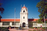
One of South Salt Lake's most notable and historic buildings is the Columbus CenterColumbus Center
One of South Salt Lake's most notable and unique buildings is the Columbus School Building which currently serves as a community center. Located at 2531 South 400 East, the Columbus School building is not only a community landmark, but a vital gathering place as well...
. Originally a school
School
A school is an institution designed for the teaching of students under the direction of teachers. Most countries have systems of formal education, which is commonly compulsory. In these systems, students progress through a series of schools...
around the turn of the 20th century, it was later used as a daycare center beginning in the 1950s. After being condemned in the late 1980s, it was renovated and expanded to include a branch of the Salt Lake County Library System as well as an auditorium
Auditorium
An auditorium is a room built to enable an audience to hear and watch performances at venues such as theatres. For movie theaters, the number of auditoriums is expressed as the number of screens.- Etymology :...
, senior center and several other facilities.
Education
South Salt Lake lies within the Granite School DistrictGranite School District
The Granite School District spreads across central Salt Lake County, Utah, serving West Valley City, Taylorsville, South Salt Lake, and Holladay; Kearns, Magna and Millcreek Township; and parts of West Jordan, Murray and Cottonwood Heights. About 70,000 students are enrolled in its programs ranging...
. It has 2 elementary schools (Lincoln and Wilson) and 1 junior high school (Granite Park). Granite High School, originally opened in 1906, was changed from a traditional high school to an alternative high school in 2006. Granite High School expanded into an "umbrella" school with various programs under its wing, including Central High, which was already an alternative school. However, the school closed for good at the end of the 2008-09 school year. On November 8, 2011, the citizens of South Salt Lake will vote to decide whether the city should purchase the 27-acre Granite High School property by means of a $25 million bond (plus $9 million in interest). The Salt Lake City campus of Broadview University is located next to the South Salt Lake city offices.
Trivia
- The world's first Kentucky Fried Chicken (now KFC) franchise was established in 1952 by Harland SandersColonel SandersHarland David "Colonel" Sanders was an American fast food businessman who founded the Kentucky Fried Chicken restaurant chain, now re-branded as KFC...
and Pete HarmanPete HarmanLeon Weston "Pete" Harman is best known for having struck a deal with Colonel Harland Sanders to open the first KFC franchise. Located in Salt Lake City, Utah it opened for business in August 1952....
in what is now part of South Salt Lake. - Zagg, manufacturer and marketer of the popular invisibleSHIELD gadget protection film, is based in South Salt Lake.