
La Verkin, Utah
Encyclopedia
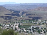
La Verkin is a city in Washington County
, Utah
, United States
. The population was 4,719 as of 2010, an increase from 3,392 in 2000. La Verkin is within walking distance of Hurricane, Utah
, and the two cities have historically had close ties.
Theories about the origin of the city's name suggest that it may be a corruption of the Spanish la virgen, after the nearby Virgin River
, or possibly an error in the transcription of the term "beaver skin."
The city made national headlines in 2001 when the City Council passed an ordinance declaring La Verkin a "United Nations-free zone".
, the city has a total area of 16.1 square miles (41.8 km²), all of it land.
of 2000, there were 3,392 people, 1,053 households, and 840 families residing in the city. The population density
was 210.3 people per square mile (81.2/km²). There were 1,158 housing units at an average density of 71.8 per square mile (27.7/km²). The racial makeup of the city was 93.81% White, 0.12% African American, 1.27% Native American, 0.21% Asian, 0.12% Pacific Islander, 1.92% from other races
, and 2.56% from two or more races. Hispanic or Latino of any race were 4.60% of the population.
There were 1,053 households out of which 44.6% had children under the age of 18 living with them, 66.3% were married couples
living together, 9.6% had a female householder with no husband present, and 20.2% were non-families. 17.0% of all households were made up of individuals and 7.5% had someone living alone who was 65 years of age or older. The average household size was 3.20 and the average family size was 3.61.
In the city the population was spread out with 35.8% under the age of 18, 9.1% from 18 to 24, 24.5% from 25 to 44, 17.5% from 45 to 64, and 13.1% who were 65 years of age or older. The median age was 29 years. For every 100 females there were 98.9 males. For every 100 females age 18 and over, there were 94.0 males.
The median income for a household in the city was $35,949, and the median income for a family was $39,432. Males had a median income of $30,051 versus $19,602 for females. The per capita income
for the city was $12,113. About 10.1% of families and 12.1% of the population were below the poverty line, including 15.7% of those under age 18 and 6.4% of those age 65 or over.
Washington County, Utah
As of the census of 2000, there were 90,354 people, 29,939 households, and 23,442 families residing in the county. The population density was 37 people per square mile . There were 36,478 housing units at an average density of 15 per square mile...
, Utah
Utah
Utah is a state in the Western United States. It was the 45th state to join the Union, on January 4, 1896. Approximately 80% of Utah's 2,763,885 people live along the Wasatch Front, centering on Salt Lake City. This leaves vast expanses of the state nearly uninhabited, making the population the...
, United States
United States
The United States of America is a federal constitutional republic comprising fifty states and a federal district...
. The population was 4,719 as of 2010, an increase from 3,392 in 2000. La Verkin is within walking distance of Hurricane, Utah
Hurricane, Utah
Hurricane is a city in Washington County, Utah. Its population was 13,748 at the 2010 U.S. Census. Along with several other areas of southwestern Utah, the Hurricane area has seen a large population growth since the 1970s, and it has blended in with neighboring city of St...
, and the two cities have historically had close ties.
Theories about the origin of the city's name suggest that it may be a corruption of the Spanish la virgen, after the nearby Virgin River
Virgin River
The Virgin River is a tributary of the Colorado River in the U.S. states of Utah, Nevada, and Arizona. The river is about long. It was designated Utah's first wild and scenic river in 2009, during the centennial celebration of Zion National Park.-Course:...
, or possibly an error in the transcription of the term "beaver skin."
The city made national headlines in 2001 when the City Council passed an ordinance declaring La Verkin a "United Nations-free zone".
Geography
According to the United States Census BureauUnited States Census Bureau
The United States Census Bureau is the government agency that is responsible for the United States Census. It also gathers other national demographic and economic data...
, the city has a total area of 16.1 square miles (41.8 km²), all of it land.
Demographics
As of the censusCensus
A census is the procedure of systematically acquiring and recording information about the members of a given population. It is a regularly occurring and official count of a particular population. The term is used mostly in connection with national population and housing censuses; other common...
of 2000, there were 3,392 people, 1,053 households, and 840 families residing in the city. The population density
Population density
Population density is a measurement of population per unit area or unit volume. It is frequently applied to living organisms, and particularly to humans...
was 210.3 people per square mile (81.2/km²). There were 1,158 housing units at an average density of 71.8 per square mile (27.7/km²). The racial makeup of the city was 93.81% White, 0.12% African American, 1.27% Native American, 0.21% Asian, 0.12% Pacific Islander, 1.92% from other races
Race (United States Census)
Race and ethnicity in the United States Census, as defined by the Federal Office of Management and Budget and the United States Census Bureau, are self-identification data items in which residents choose the race or races with which they most closely identify, and indicate whether or not they are...
, and 2.56% from two or more races. Hispanic or Latino of any race were 4.60% of the population.
There were 1,053 households out of which 44.6% had children under the age of 18 living with them, 66.3% were married couples
Marriage
Marriage is a social union or legal contract between people that creates kinship. It is an institution in which interpersonal relationships, usually intimate and sexual, are acknowledged in a variety of ways, depending on the culture or subculture in which it is found...
living together, 9.6% had a female householder with no husband present, and 20.2% were non-families. 17.0% of all households were made up of individuals and 7.5% had someone living alone who was 65 years of age or older. The average household size was 3.20 and the average family size was 3.61.
In the city the population was spread out with 35.8% under the age of 18, 9.1% from 18 to 24, 24.5% from 25 to 44, 17.5% from 45 to 64, and 13.1% who were 65 years of age or older. The median age was 29 years. For every 100 females there were 98.9 males. For every 100 females age 18 and over, there were 94.0 males.
The median income for a household in the city was $35,949, and the median income for a family was $39,432. Males had a median income of $30,051 versus $19,602 for females. The per capita income
Per capita income
Per capita income or income per person is a measure of mean income within an economic aggregate, such as a country or city. It is calculated by taking a measure of all sources of income in the aggregate and dividing it by the total population...
for the city was $12,113. About 10.1% of families and 12.1% of the population were below the poverty line, including 15.7% of those under age 18 and 6.4% of those age 65 or over.