

Jordan River (Utah)
Encyclopedia
The Jordan River in the U.S. state of Utah
is a river about 51 miles (82.1 km) long. Regulated by pumps at its headwaters at Utah Lake
, it flows northward through the Salt Lake Valley
and empties into the Great Salt Lake
. Four of Utah's five largest cities—Salt Lake City, West Valley City
, West Jordan
and Sandy
—border the river. More than a million people live in the Jordan Subbasin, which is the part of the Jordan River watershed that lies within Salt Lake and Davis counties. During the Pleistocene
, the area was part of Lake Bonneville
.
Members of the Desert Archaic Culture were the earliest known inhabitants of the region; an archaeological site found along the river dates back 3,000 years. Mormon pioneers led by Brigham Young
were the first European American
settlers, arriving in July 1847 and establishing farms and settlements along the river and its tributaries. The growing population, needing water for drinking, irrigation, and industrial use in an arid climate, dug ditches and canals, built dams, and installed pumps to create a highly regulated river.
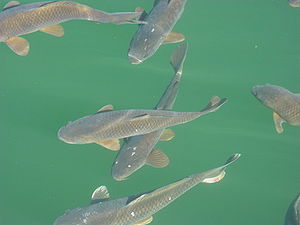
Although the Jordan was originally a cold-water fishery
with 13 native species including Bonneville cutthroat trout
, it has become a warm-water fishery where common carp
is most abundant. Heavily polluted for many years by raw sewage, agricultural runoff, and mining wastes, the river became cleaner in the 1960s when modern sewage treatment removed many pollutants. In the 21st century, pollution is further limited by the Clean Water Act
, and, in some cases, the Superfund
program. Once the home of bighorn sheep
and beaver
, the contemporary river is frequented by raccoon
s, red fox
es, and domestic pets. Along with the Great Salt Lake and Utah Lake, it is still an important avian resource visited by more than 200 bird species.
Big Cottonwood
, Little Cottonwood
, Red Butte
, Mill, Parley's, and City creeks, as well as smaller streams flow through the subbasin. The Jordan River Parkway
along the river includes natural areas, botanical gardens, golf courses and a proposed 40 miles (64.4 km) bicycle and pedestrian trail, much of which has been completed.
's only outflow, and originates at the northern end of the lake between the cities of Lehi
and Saratoga Springs
. It then meanders north through the Utah Valley
for approximately 8 miles (12.9 km) until it passes through a gorge in the Traverse Mountains, known as the Jordan Narrows. The Utah National Guard
base at Camp Williams
lies on the western side of the river through much of the Jordan Narrows. The Turner Dam, located 41.8 miles (67.3 km) from the river's mouth (or at river mile
41.8) and within the boundaries of the Jordan Narrows, is the first of two dams of the Jordan River. The Turner dam diverts water to the right or easterly into the East Jordan Canal and to the left or westerly toward the Utah and Salt Lake Canal. Two pumping stations, situated next to the Turner Dam, divert water to the west into the Provo Reservoir Canal, Utah Lake Distribution Canal and Jacob-Welby Canal. The Provo Reservoir Canal runs north through Salt Lake County, Jacob-Welby runs south through Utah County and the Utah Lake Distribution Canal runs both north and south eventually leading back into Utah Lake. Outside the narrows, the river reaches the second dam, known as the Joint Dam, which is 39.9 miles (64.2 km) from the river's mouth. The Joint Dam diverts water to the east for the Jordan and Salt Lake City Canals and to the west for the South Jordan Canal.
The river then flows through the middle of the Salt Lake Valley, initially moving through the town of Bluffdale
and then forming the border between the cities of Riverton
and Draper
. The river then enters the city of South Jordan
where it merges with Midas Creek from the west. Upon leaving South Jordan, the river forms the border between the cities of West Jordan on the west and Sandy and Midvale
on the east. From the west, Bingham Creek enters in West Jordan. Dry Creek, an eastern tributary, combines with the main river in Sandy. The river then forms the border between the cities of Taylorsville
and West Valley City on the west and Murray
and South Salt Lake
on the east. The river flows underneath Interstate 215
in Murray. Little and Big Cottonwood Creek
s enter from the east in Murray, 21.7 miles (34.9 km) and 20.6 miles (33.2 km) from the mouth respectively. Mill Creek enters on the east in South Salt Lake, 17.3 miles (27.8 km) from the mouth. The river runs through the middle of Salt Lake City, where the river travels underneath Interstate 80 a mile west of downtown of Salt Lake City and again underneath Interstate 215 in the northern portion of Salt Lake City. Interstate 15 parallels the river's eastern flank throughout Salt Lake County. At 16 miles (25.7 km) from the mouth, the river enters into the Surplus Canal channel. The Jordan River physically diverts from the Surplus Canal through four gates and heads north with the Surplus Canal heading north-west. Parley's, Emigration, Red Butte Creeks converge from the east through an underground pipe, 14.2 miles (22.9 km) from the mouth. City Creek also enters via an underground pipe, 11.5 miles (18.5 km) from the river's mouth. The length of the river and the elevation of its mouth varies year to year depending on the fluctuations of the Great Salt Lake caused by weather conditions. The lake has an average elevation of 4200 feet (1,280.2 m) which can deviate by 10 feet (3 m). The Jordan River then continues for 9 to 12 mi (14.5 to 19.3 km) with Salt Lake County on the west and North Salt Lake
and Davis County on the east until it empties into the Great Salt Lake.
maintains a stream gauge
in Salt Lake City that shows annual runoff from the period between 1980–2003 is just over 150000 acre.ft per year or 19 percent of the total 800000 acre.ft of water entering the Jordan River from all sources. The Surplus Canal carries almost 60 percent of the water into the Great Salt Lake with various irrigation canals responsible for the rest. The amount of water entering the Jordan River from Utah Lake is just over 400000 acre.ft per year. Inflow from the 11 largest streams feeding the Jordan River, sewage treatment plants and ground water each accounts for approximately 15 percent of water entering the river.
, near the town of Alta
. The Oquirrh Mountains
rise on the west, with a high point of over 9000 feet (2,743.2 m) above sea level at Farnsworth Peak
. The low point of 4200 feet (1,280.2 m) is at the river's mouth, where the river enters the Great Salt Lake. Both the Oquirrh and Wasatch Mountains are fault-block mountain
s created from normal-slip faults where the mountains rise at the fault and the valley floor drops. The Wasatch Fault
runs along the western edge of the Wasatch Mountains and the Oquirrh Fault runs along the eastern edge of the Oquirrh Mountains.
From approximately 75,000 to 8,000 years ago, much of what is now northern Utah was covered by a Pleistocene lake called Lake Bonneville
. At its greatest extent, Lake Bonneville reached an elevation of 5200 feet (1,585 m) above sea level and had a surface area of 19800 square miles (51,281.8 km²). The lake left behind lacustrine sediments
, which resulted in a relatively flat lake bed, and the valley floors seen today. As the region experienced increasingly warmer and drier climate over time, Lake Bonneville's water levels receded, leaving the Great Salt Lake and Utah Lake as remnants. The river's greatest slope, 27 ft/mi, is in the Jordan Narrows, while the rest of the river has a more gentle slope of 2 ft/mi.
Approximately 237000 acres (959.1 km²) (46 percent of land area) of the Jordan Subbasin is in the Wasatch, Oquirrh and Traverse mountains. The United States Forest Service
manages 91000 acres (368.3 km²) of land in the Wasatch Range. The vast majority of the Oquirrh Range is privately held, with Kennecott Copper Mine owning most of the land. The State of Utah has scattered land holdings of 9800 acres (39.7 km²) throughout the subbasin and owns the beds of all navigable streams and lakes.
The Jordan Subbasin has two distinct climate zones. The lower elevations are characterized as a cold, semi-arid climate, with four distinct seasons. Both summer and winter are long with hot, dry summers and cold, snowy winters. Salt Lake City receives 61 inches (154.9 cm) of snow annually, part of a total of 16.5 inches (419.1 mm) of precipitation per year. The mean maximum temperature is 91 °F (32.8 °C) in July and 37 °F (2.8 °C) in January Areas of higher elevation have two distinct seasons, summer and winter. One of the areas of highest elevation, Alta, Utah, receives 544 inches (1,381.8 cm) of snow annually, part of a total of 52 inches (1,320.8 mm) of precipitation per year. The mean maximum temperature is 71 °F (21.7 °C) in July and 29 °F (-1.7 °C) in January.
In 1776, Franciscan missionary Silvestre Vélez de Escalante was trying to find a land route from Santa Fe
, New Mexico
, to Monterey
, California
. His party included twelve Spanish colonials and two Utes from the Utah Valley Timpanogots band who acted as guides. On September 23, 1776, the party entered Utah Valley at the present-day city of Spanish Fork
. The local Timanogots villagers hosted them and told them of the lake to the north. In his journal, Escalante described Utah Lake as a "lake, which must be six leagues wide and fifteen leagues long, [and] extends as far as one of these valleys. It runs northwest through a narrow passage, and according to what they told us, it communicates with others much larger." The Great Salt Lake was described as the "other lake with which this one communicates, according to what they told us, [and] covers many leagues, and its waters are noxious and extremely salty."
The next group of Europeans to see the Jordan River was the party of Étienne Provost
, a French Canadian
trapper. In October 1824, Provost's party was lured into a Shoshone camp somewhere along the Jordan River, where they were attacked in retaliation for the murder of a local chief. In truth, the murder was committed by a member of Peter Skene Ogden
's party. The men were caught off guard, and fifteen perished, but Provost and two others escaped.
On July 22, 1847, the first party of Mormon pioneers arrived in the Salt Lake Valley, and five days later another party led by Brigham Young
crossed the Jordan River and bathed in the Great Salt Lake. The River Jordan drains the Sea of Galilee
into the Dead Sea
in a way which the settlers found remarkably similar to the way the as-yet-unnamed local river drained Utah Lake into the saline Great Salt Lake. This similarity influenced the eventual name of the river, and on August 22, 1847, a conference was held and the name Western Jordan River was decided upon, although it was later shortened to the Jordan River. By 1850, settlements were established along the Jordan River, Big Cottonwood Creek, Little Cottonwood Creek, Mill Creek, Parley's Creek and Emigration Creek. In 1850, Captain Howard Stansbury
of the United States Army Corps of Topographical Engineers traveled the entire length of the Jordan River, surveying and making observations of the wildlife.
Around the year 1887 at Bingham Canyon
in the Oquirrh Mountains, low-grade copper deposits were discovered and mining claims were filed. Bingham Canyon is a porphyry copper deposit
where magma
containing copper, molybdenum, gold and other minerals slowly moved its way to the surface and cooled into rock. By 1890, underground copper mining had started, and in 1907, Kennecott Copper Mine started open pit mining. In the early 20th century, mills were established near the Jordan River in Midvale and West Jordan to process ore. As of 2010, Kennecott Copper Mine's open pit is 2.8 miles (4.5 km) wide and 0.8 miles (1.3 km) deep.
Throughout the 19th century and up to the 1940s, water from the Jordan River watershed sustained the agrarian society of the Salt Lake Valley. In 1950, Salt Lake County had 489000 acres (197,891.5 ha) devoted to farming. By 1992, however, the rapid urbanization of the Salt Lake Valley had reduced the amount of land devoted to farming to 108000 acres (43,706.1 ha), which was further reduced to 82267 acres (33,292.3 ha) by 2002.
, one of the founders of West Jordan in 1850, to provide water for his mill and one built by Alexander Beckstead, a founder of South Jordan, who built the Beckstead Ditch in 1859 to provide water for farmland. Many other small dams and ditches were also constructed in the first 25 years, several of which are still used as of 2010. All of these ditches irrigated only small amounts of land in the Jordan River floodplain; the largest, the Beckstead Ditch, irrigated 580 acres (234.7 ha).
By the late 1860s, it became apparent that new, larger canals needed to be built if more acreage was to be farmed. The first dam in the Jordan Narrows was constructed in 1872 and raised in 1880, sparking an outcry from residents living near Utah Lake who thought the dam was responsible for raising the level of the lake. After several years of dispute, a commission was established to determine an acceptable compromise for the elevation of Utah Lake. The commission's 1885 decision stated that if the lake level were to rise above the established compromise level, the Jordan River could not be impeded by either dams or flood gates. Additionally, the commission stated that after water pumps were installed at the source of the river, the pumps should all be working if the lake were to rise above the compromise level. However, if the lake level fell below the compromise level, pumps could be turned off so that water could be held for storage in Utah Lake.
In 1875, the first large canal, the South Jordan Canal, was completed and it brought water to the area above the bluffs of the Jordan River for the first time. All told, five large canals that originated from the dams in the Jordan Narrows were completed by 1883. A second dam was built in 1890 a few miles downstream from the first dam and was constructed to better regulate the flow of two canals. Both dams have been rebuilt in subsequent years and operate as diversion points for canals rather than impounding water by the use of sluice gates and head gates. The drought of 1901–1902 caused the Jordan River, on occasion, to stop flowing, and in response to the drought a pumping plant was installed at the outlet from Utah Lake. It was the largest pumping plant in the United States at the time, and contained seven pumps with a total capacity of 700 cubic feet (19.8 m³) per second. Twice, during the droughts of 1934 and 1992, Utah Lake levels dropped so low that the pumps were rendered useless and the Jordan River actually ran dry. In the 1950s, due to flood control measures to increase river velocity, large sections of the river were straightened in Salt Lake County. As part of the straightening process, meanders or curves in the river were cut off and the channel slope was increased. The river was also shifted to opposite sides of the flood plain in Midvale and Murray as part of local smelter operations.
Floods in 1983–1984 caused Utah Lake to overflow its banks, flooding homes and farmland in Provo
, Lehi and present-day Saratoga Springs. Dikes had to be constructed around Interstate 15
in Provo to prevent Utah Lake flooding the freeway. Big Cottonwood, Parley's, Emigration and City creeks flowed down sand-bag lined streets in order to manage the overflowing streams. Additional dikes were built at the Great Salt Lake to protect railroad lines and Interstate 80
. As a result of the flooding, the Utah Lake compromise level was amended to 4489 feet (1,368.2 m).
 In the Jordan River, invertebrates not only play an important role as a source of food for fish and other aquatic life, they also function as a parameter by which to measure water quality and the health of the river. There are 34 different groups of invertebrates found in the Jordan River, most commonly of the class Oligochaeta
(which includes earthworms), along with mosquito
larvae and caddisfly larvae. The state of Utah maintains a Sensitive Species List that includes "those species for which there is credible scientific evidence to substantiate a threat to continued population viability." The Lyrate mountainsnail and the western pearlshell mussel
, both native to the Jordan River watershed, are found on this list. A 2007 survey of invertebrates and their response to pollution stated that the Jordan River was substantially to severely impaired with organic pollution and that it contained reduced levels of dissolved oxygen.
Historically, the Jordan River was a cold-water fishery that contained 13 native species, including the Bonneville cutthroat trout
, Utah Lake sculpin
, June sucker
, Mottled sculpin
, Utah chub
and the Utah Sucker
. Today, the Jordan River is a warm-water fishery with the Utah Sucker and the endangered
June Sucker present only in Utah Lake. The Utah chub, however, is still found in the Jordan River. The most common species of fish encountered today is the common carp
, which was introduced into the Jordan River and Utah Lake as a source of food after overfishing caused the depletion of native species stocks. The Utah Division of Wildlife Resources
regularly stocks the river with catfish
and rainbow trout
.
 Vegetation in the watershed is closely tied to elevation and precipitation levels. About 30 percent of the basin, mostly at higher elevation levels, is populated with oak
, aspen
and coniferous trees. At the lower levels, 27 percent of the basin is rich in mountain-brush, sagebrush
, juniper
and grasses. About 34 percent of the Jordan River basin is classified as urban.
Russian olive and tamarisk or salt cedar trees now dominate the Jordan River floodplain where willow trees and cottonwood trees would once have been found. Plant species such as foxtail barley, saltgrass, rabbitbrush
, cattails and other reeds are still found in small pockets along the river. Exotic pasture grasses such as orchard grass, bluegrass
, redtop bentgrass
, quackgrass, wheatgrass
and fescue
have become the common species of grass. The vulnerable
flower, Ute's Ladies'-tresses
, can also be found along the river.
and lead
. In 1962, the river in Midvale recorded a total coliform level of about 3 million per 100 milliliters, even though the state of Utah criteria for the total number of coliform bacteria in water samples should not exceed 5,000 per 100 milliliters. In 1965, a new sewage treatment plant came on-line in Salt Lake City that prevented 32000000 USgal/d of raw sewage from being dumped into a canal.
The Utah Division of Water Quality
and Utah Division of Drinking Water are responsible for the regulation and management of water quality in the State of Utah. Streams that exceed the standard contamination levels are placed on the 303d list in accordance with the Clean Water Act
. The Act also requires states to identify impaired water bodies every two years and develop a total maximum daily load
(TMDL) for pollutants that may cause impairments in the various water bodies. The Jordan River and Little Cottonwood Creek were included on the 2006 303d list; parameters that exceeded the standard level for at least part of the Jordan River include temperature, dissolved oxygen, total dissolved solids
, E. Coli
and salinity.
. The Environmental Protection Agency is the federal agency that determines if a particular site is hazardous, prepares a course of action to reduce the hazard, and finds the parties responsible for the pollution. If a site is listed with the Superfund
program, federal dollars are available for cleanup.
The Kennecott South Zone/Bingham site contains contamination from Kennecott Copper Mine's operation in Copperton
, at the base of the Oquirrh Mountains
to Bingham Creek and Butterfield Creek. A 72 square miles (186.5 km²) plume of lead, arsenic and sulfates (covering 9 percent of the watershed) currently contaminates the ground water from the mine site all the way to the Jordan River. The largest inland reverse osmosis
plant in the country was built in 2006 to clean up the ground water and a second plant has been scheduled for construction; completion of the ground water cleanup, however, is not projected until 2040. In 1998, the site was removed from the Superfund list due to Kennecott's progress in the cleanup and a consent decree
legally obligating Kennecott to continue the rest of the cleanup.
The Murray Smelter site was the location of a large lead smelter in operation from 1872 until 1949. The 142 acres (57.5 ha) site contained groundwater contamination from arsenic
and lead, but the majority of the cleanup was completed in 2001.
In Midvale, there are two Superfund sites that sit along 4 percent of the Jordan River. The Midvale Slag site is a 446 acres (180.5 ha) site adjacent to 6800 feet (2,072.6 m) of the Jordan River. From 1871 to 1958, the site contained five separate smelters that processed ores from Kennecott and other mines. The site was contaminated with lead, arsenic, chromium, and cadmium. Cleanup of the property is complete, although the Jordan River Riparian Project still underway as of 2010. Sharon Steel
was a 460 acres (186.2 ha) site adjacent to 4500 feet (1,371.6 m) of the Jordan River which was used, from 1902 to 1971, for smelting copper from Kennecott Copper Mine. The site was contaminated with lead, arsenic, iron, manganese, and zinc. Cleanup has been completed, and the site taken off the Superfund list in 2004.
mill and storage for uranium. In 1989, surface contamination cleanup was completed with tailings, radioactively contaminated soil material, and debris removed from the site. However, 700000000 gallons (2,649,788.4 m³) of contaminated shallow ground water still remain, and studies are underway to determine what action should be taken.
 The Jordan River Parkway was originally proposed in 1971 as a flood control measure with two reservoirs, restoration of wetlands, shoreline roads for cars, walking trails, and parks. By 1986, $18 million had been used to purchase lands around the Jordan River and to construct the Murray Golf Course, several smaller parks and about 4 miles (6.4 km) of canoe runs and trails. As of 2010, the majority of the 40 miles (64.4 km) continuous mixed-use trail has been finished from Utah Lake to the Davis County border. A water trail for canoe
ing and kayak
ing is also being constructed, but dams, bridges, weir
s and other obstacles hamper the use of the river.
Riverside parks include the International Peace Gardens
, 8.5 acres (3.4 ha) of gardens with each garden representing a different country; Redwood Nature Area, about 50 acres (20.2 ha) of natural areas; South Jordan's Riverfront Park, 59 acres (23.9 ha) of trails, fishing ponds and natural areas; Thanksgiving Point
, including 15 themed gardens spread over 59 acres (23.9 ha) and a 200 acres (80.9 ha) 18-hole golf course; and Utah County's Willow Park, 50 acres (20.2 ha) of camping and wildlife areas.
Utah
Utah is a state in the Western United States. It was the 45th state to join the Union, on January 4, 1896. Approximately 80% of Utah's 2,763,885 people live along the Wasatch Front, centering on Salt Lake City. This leaves vast expanses of the state nearly uninhabited, making the population the...
is a river about 51 miles (82.1 km) long. Regulated by pumps at its headwaters at Utah Lake
Utah Lake
Utah Lake is a freshwater lake in the U.S. state of Utah. On the western side of Utah Valley, the lake is overlooked by Mount Timpanogos and Mount Nebo. The lake's only river outlet, the Jordan River, is a tributary of the Great Salt Lake and is highly regulated with pumps. Evaporation accounts...
, it flows northward through the Salt Lake Valley
Salt Lake Valley
Salt Lake Valley is a valley in Salt Lake County in the north-central portion of the U.S. state of Utah. It contains Salt Lake City and many of its suburbs, notably West Valley City, Murray, Sandy, and West Jordan; its total population is 1,029,655 as of 2010...
and empties into the Great Salt Lake
Great Salt Lake
The Great Salt Lake, located in the northern part of the U.S. state of Utah, is the largest salt water lake in the western hemisphere, the fourth-largest terminal lake in the world. In an average year the lake covers an area of around , but the lake's size fluctuates substantially due to its...
. Four of Utah's five largest cities—Salt Lake City, West Valley City
West Valley City, Utah
West Valley City is a city in Salt Lake County and a suburb of Salt Lake City in the U.S. state of Utah. The population was 129,480 at the 2010 census,...
, West Jordan
West Jordan, Utah
West Jordan is a city in Salt Lake County, Utah, United States. West Jordan is a rapidly growing suburb of Salt Lake City and has a mixed economy. According to the 2010 Census, the city had a population of 103,712, placing it as the fourth most populated in the state. The city occupies the...
and Sandy
Sandy, Utah
Sandy is a city in Salt Lake County, Utah, United States. It is a suburb of Salt Lake City. The population was 87,461 at the 2010 census, making it the sixth-largest city in Utah....
—border the river. More than a million people live in the Jordan Subbasin, which is the part of the Jordan River watershed that lies within Salt Lake and Davis counties. During the Pleistocene
Pleistocene
The Pleistocene is the epoch from 2,588,000 to 11,700 years BP that spans the world's recent period of repeated glaciations. The name pleistocene is derived from the Greek and ....
, the area was part of Lake Bonneville
Lake Bonneville
Lake Bonneville was a prehistoric pluvial lake that covered much of North America's Great Basin region. Most of the territory it covered was in present-day Utah, though parts of the lake extended into present-day Idaho and Nevada. Formed about 32,000 years ago, it existed until about 14,500 years...
.
Members of the Desert Archaic Culture were the earliest known inhabitants of the region; an archaeological site found along the river dates back 3,000 years. Mormon pioneers led by Brigham Young
Brigham Young
Brigham Young was an American leader in the Latter Day Saint movement and a settler of the Western United States. He was the President of The Church of Jesus Christ of Latter-day Saints from 1847 until his death in 1877, he founded Salt Lake City, and he served as the first governor of the Utah...
were the first European American
European American
A European American is a citizen or resident of the United States who has origins in any of the original peoples of Europe...
settlers, arriving in July 1847 and establishing farms and settlements along the river and its tributaries. The growing population, needing water for drinking, irrigation, and industrial use in an arid climate, dug ditches and canals, built dams, and installed pumps to create a highly regulated river.
Although the Jordan was originally a cold-water fishery
Fishery
Generally, a fishery is an entity engaged in raising or harvesting fish which is determined by some authority to be a fishery. According to the FAO, a fishery is typically defined in terms of the "people involved, species or type of fish, area of water or seabed, method of fishing, class of boats,...
with 13 native species including Bonneville cutthroat trout
Bonneville cutthroat trout
The Bonneville cutthroat trout is a subspecies of cutthroat trout native to tributaries of the Great Salt Lake, U.S.A. Most of the fish's current and historic range is in Utah, but they are also found in Idaho, Wyoming, and Nevada...
, it has become a warm-water fishery where common carp
Common carp
The Common carp is a widespread freshwater fish of eutrophic waters in lakes and large rivers in Europe and Asia. The wild populations are considered vulnerable to extinction, but the species has also been domesticated and introduced into environments worldwide, and is often considered an invasive...
is most abundant. Heavily polluted for many years by raw sewage, agricultural runoff, and mining wastes, the river became cleaner in the 1960s when modern sewage treatment removed many pollutants. In the 21st century, pollution is further limited by the Clean Water Act
Clean Water Act
The Clean Water Act is the primary federal law in the United States governing water pollution. Commonly abbreviated as the CWA, the act established the goals of eliminating releases of high amounts of toxic substances into water, eliminating additional water pollution by 1985, and ensuring that...
, and, in some cases, the Superfund
Superfund
Superfund is the common name for the Comprehensive Environmental Response, Compensation, and Liability Act of 1980 , a United States federal law designed to clean up sites contaminated with hazardous substances...
program. Once the home of bighorn sheep
Bighorn Sheep
The bighorn sheep is a species of sheep in North America named for its large horns. These horns can weigh up to , while the sheep themselves weigh up to . Recent genetic testing indicates that there are three distinct subspecies of Ovis canadensis, one of which is endangered: Ovis canadensis sierrae...
and beaver
Beaver
The beaver is a primarily nocturnal, large, semi-aquatic rodent. Castor includes two extant species, North American Beaver and Eurasian Beaver . Beavers are known for building dams, canals, and lodges . They are the second-largest rodent in the world...
, the contemporary river is frequented by raccoon
Raccoon
Procyon is a genus of nocturnal mammals, comprising three species commonly known as raccoons, in the family Procyonidae. The most familiar species, the common raccoon , is often known simply as "the" raccoon, as the two other raccoon species in the genus are native only to the tropics and are...
s, red fox
Red Fox
The red fox is the largest of the true foxes, as well as being the most geographically spread member of the Carnivora, being distributed across the entire northern hemisphere from the Arctic Circle to North Africa, Central America, and the steppes of Asia...
es, and domestic pets. Along with the Great Salt Lake and Utah Lake, it is still an important avian resource visited by more than 200 bird species.
Big Cottonwood
Big Cottonwood Creek
Big Cottonwood Creek is one of the largest streams entering Salt Lake Valley from the east from the Wasatch Mountains. The creek flows through the Big Cottonwood Canyon in a westerly direction until it emerges into Salt Lake Valley about eighteen miles from its highest source...
, Little Cottonwood
Little Cottonwood Creek
Little Cottonwood Creek is one of the principal streams entering Salt Lake Valley from the east rises near the summit of the Wasatch Mountains a short distance south of the ski resort town of Alta and flows in a westerly direction through Little Cottonwood Canyon until it emerges into Salt Lake...
, Red Butte
Red Butte Creek
Red Butte Creek is a small stream whose headwaters are found in the northeast part of Salt Lake County. It flows west through the Red Butte Garden and Arboretum, by the University of Utah, Fort Douglas and flows southwesterly through Salt Lake City’s Liberty Park before forming a confluence with...
, Mill, Parley's, and City creeks, as well as smaller streams flow through the subbasin. The Jordan River Parkway
Jordan River Parkway
The Jordan River Parkway is an approximately urban park that runs along the Jordan River within the US state of Utah. The parkway follows along the river from Utah Lake in Utah County, through Salt Lake County and onto the Great Salt Lake in Davis County. The majority of a mixed-use trail has...
along the river includes natural areas, botanical gardens, golf courses and a proposed 40 miles (64.4 km) bicycle and pedestrian trail, much of which has been completed.
Course
The Jordan River is the Utah LakeUtah Lake
Utah Lake is a freshwater lake in the U.S. state of Utah. On the western side of Utah Valley, the lake is overlooked by Mount Timpanogos and Mount Nebo. The lake's only river outlet, the Jordan River, is a tributary of the Great Salt Lake and is highly regulated with pumps. Evaporation accounts...
's only outflow, and originates at the northern end of the lake between the cities of Lehi
Lehi, Utah
-Attractions:Lehi Roller MillsLehi Roller Mills was founded in 1906 by a co-op of farmers. George G. Robinson purchased the mill in 1910, and since then it has remained in the family. It is run today by grandson R. Sherman Robinson....
and Saratoga Springs
Saratoga Springs, Utah
Saratoga Springs is a city in Utah County, Utah, United States. The elevation is 4,505 feet. It is part of the Provo–Orem, Utah Metropolitan Statistical Area. The city is a relatively new development along the northern shores of Utah Lake. It was incorporated on December 31, 1997 and has...
. It then meanders north through the Utah Valley
Utah Valley
Utah Valley is a valley in North Central Utah located in Utah County, and is considered part of the Wasatch Front. It contains Provo, Orem, and their suburbs, including Highland, Eagle Mountain, Saratoga Springs, Mapleton, Spanish Fork, Lindon, Pleasant Grove, Springville, Lehi, Payson, and...
for approximately 8 miles (12.9 km) until it passes through a gorge in the Traverse Mountains, known as the Jordan Narrows. The Utah National Guard
Utah National Guard
The Utah National Guard consists of the:* Utah Army National Guard**19th Special Forces Group **85th WMD CST**97th Troop Command**115th Engineer Group **211th Aviation Group**300th MI Brigade **640th Regiment...
base at Camp Williams
Camp W. G. Williams
Camp W. G. Williams, also known as Army Garrison Camp Williams, is a National Guard training site operated by the Utah National Guard. It is located south of Bluffdale, west of Lehi, and north of Saratoga Springs and Cedar Fort, approximately south of Salt Lake City, straddling the border between...
lies on the western side of the river through much of the Jordan Narrows. The Turner Dam, located 41.8 miles (67.3 km) from the river's mouth (or at river mile
River mile
In the United States, a River mile is a measure of distance in miles along a river from its mouth. River mile numbers begin at zero and increase further upstream. The corresponding metric unit using kilometers is the River kilometer...
41.8) and within the boundaries of the Jordan Narrows, is the first of two dams of the Jordan River. The Turner dam diverts water to the right or easterly into the East Jordan Canal and to the left or westerly toward the Utah and Salt Lake Canal. Two pumping stations, situated next to the Turner Dam, divert water to the west into the Provo Reservoir Canal, Utah Lake Distribution Canal and Jacob-Welby Canal. The Provo Reservoir Canal runs north through Salt Lake County, Jacob-Welby runs south through Utah County and the Utah Lake Distribution Canal runs both north and south eventually leading back into Utah Lake. Outside the narrows, the river reaches the second dam, known as the Joint Dam, which is 39.9 miles (64.2 km) from the river's mouth. The Joint Dam diverts water to the east for the Jordan and Salt Lake City Canals and to the west for the South Jordan Canal.
The river then flows through the middle of the Salt Lake Valley, initially moving through the town of Bluffdale
Bluffdale, Utah
Bluffdale is a city in Salt Lake County, Utah, USA. It is part of the Salt Lake City, Utah Metropolitan Statistical Area. The population was 4,700 according to the 2000 census...
and then forming the border between the cities of Riverton
Riverton, Utah
Riverton is a city in Salt Lake County, Utah, United States. It is part of the Salt Lake City, Utah Metropolitan Statistical Area. The population was 38,753 at the 2010 census. Riverton is one of the fastest-growing cities in the state of Utah, and was ranked by CNN Money Magazine as the 60th best...
and Draper
Draper, Utah
Draper is a city in Salt Lake and Utah Counties in the U.S. state of Utah, located about south of Salt Lake City along the Wasatch Front. Between 1990 and 2000 Draper was Utah's fastest-growing city over 5,000 people . Its population in 1990 was 7,143 and had grown to 25,220 by the 2000 census...
. The river then enters the city of South Jordan
South Jordan, Utah
South Jordan is a city in the U.S. state of Utah. The city lies in the Salt Lake Valley between the peaks of the Oquirrh Mountains and the peaks of the Wasatch Mountains and is part of the Salt Lake City metropolitan area...
where it merges with Midas Creek from the west. Upon leaving South Jordan, the river forms the border between the cities of West Jordan on the west and Sandy and Midvale
Midvale, Utah
Midvale is a city in Salt Lake County, Utah, United States. It is part of the Salt Lake City, Utah Metropolitan Statistical Area. The population was 27,029 at the 2000 census.-Geography:Midvale is located at ....
on the east. From the west, Bingham Creek enters in West Jordan. Dry Creek, an eastern tributary, combines with the main river in Sandy. The river then forms the border between the cities of Taylorsville
Taylorsville, Utah
Taylorsville is a city in Salt Lake County, Utah, United States. It is part of the Salt Lake City, Utah Metropolitan Statistical Area. The population was 57,439 at the 2000 census...
and West Valley City on the west and Murray
Murray, Utah
Murray is a city situated on the Wasatch Front in the core of Salt Lake Valley in the U.S. state of Utah. Named for territorial governor Eli Murray, it is the state's fourteenth largest city. According to the 2010 census, Murray has approximately 46,746 residents.Murray is close to Salt Lake City,...
and South Salt Lake
South Salt Lake, Utah
South Salt Lake is a city in Salt Lake County, Utah, United States, part of the Salt Lake City, Utah Metropolitan Statistical Area. The population was 23,617 at the 2010 census.-History:...
on the east. The river flows underneath Interstate 215
Interstate 215 (Utah)
Interstate 215 , also known locally as the belt route or two-fifteen, is an auxiliary interstate in the U.S. state of Utah that forms a 270-degree loop around Salt Lake City and many of its suburbs...
in Murray. Little and Big Cottonwood Creek
Big Cottonwood Creek
Big Cottonwood Creek is one of the largest streams entering Salt Lake Valley from the east from the Wasatch Mountains. The creek flows through the Big Cottonwood Canyon in a westerly direction until it emerges into Salt Lake Valley about eighteen miles from its highest source...
s enter from the east in Murray, 21.7 miles (34.9 km) and 20.6 miles (33.2 km) from the mouth respectively. Mill Creek enters on the east in South Salt Lake, 17.3 miles (27.8 km) from the mouth. The river runs through the middle of Salt Lake City, where the river travels underneath Interstate 80 a mile west of downtown of Salt Lake City and again underneath Interstate 215 in the northern portion of Salt Lake City. Interstate 15 parallels the river's eastern flank throughout Salt Lake County. At 16 miles (25.7 km) from the mouth, the river enters into the Surplus Canal channel. The Jordan River physically diverts from the Surplus Canal through four gates and heads north with the Surplus Canal heading north-west. Parley's, Emigration, Red Butte Creeks converge from the east through an underground pipe, 14.2 miles (22.9 km) from the mouth. City Creek also enters via an underground pipe, 11.5 miles (18.5 km) from the river's mouth. The length of the river and the elevation of its mouth varies year to year depending on the fluctuations of the Great Salt Lake caused by weather conditions. The lake has an average elevation of 4200 feet (1,280.2 m) which can deviate by 10 feet (3 m). The Jordan River then continues for 9 to 12 mi (14.5 to 19.3 km) with Salt Lake County on the west and North Salt Lake
North Salt Lake, Utah
North Salt Lake is a city in Davis County, Utah, United States. It is part of the Ogden–Clearfield, Utah Metropolitan Statistical Area. The population was 8,749 at the 2000 census.-Geography:North Salt Lake is located at ....
and Davis County on the east until it empties into the Great Salt Lake.
Discharge
The United States Geological SurveyUnited States Geological Survey
The United States Geological Survey is a scientific agency of the United States government. The scientists of the USGS study the landscape of the United States, its natural resources, and the natural hazards that threaten it. The organization has four major science disciplines, concerning biology,...
maintains a stream gauge
Stream gauge
A stream gauge, stream gage or gauging station is a location used by hydrologists or environmental scientists to monitor and test terrestrial bodies of water. Hydrometric measurements of water surface elevation and/or volumetric discharge are generally taken and observations of biota may also be...
in Salt Lake City that shows annual runoff from the period between 1980–2003 is just over 150000 acre.ft per year or 19 percent of the total 800000 acre.ft of water entering the Jordan River from all sources. The Surplus Canal carries almost 60 percent of the water into the Great Salt Lake with various irrigation canals responsible for the rest. The amount of water entering the Jordan River from Utah Lake is just over 400000 acre.ft per year. Inflow from the 11 largest streams feeding the Jordan River, sewage treatment plants and ground water each accounts for approximately 15 percent of water entering the river.
Watershed
The Jordan Subbasin, as defined by the United States Geological Survey, is located entirely within Salt Lake and Davis counties in a roughly rectangular area of 791 square miles (2,048.7 km²). The Subbasin is part of the larger 3830 square miles (9,919.7 km²) Jordan River Basin that includes the upper Jordan River, Utah Lake, Provo and Spanish Fork Subbasins. Four of the five largest cities in Utah are in Salt Lake County. The Jordan River flows through Sandy, with a 2008 population of 96,660; West Jordan, population 104,447; West Valley City, population 123,447; and Salt Lake City, population 181,698. Flanked on either side by mountain ranges, the topography of the land varies greatly. The Wasatch Mountains rise on the east, with a high point of 11100 feet (3,383.3 m) above sea level at Twin PeaksTwin Peaks (Utah)
There are actually two sets of well-known Twin Peaks of the Wasatch Front in Utah. "Broad's Fork" Twin Peaks, overlooking the Salt Lake Valley, and "American Fork" Twin Peaks which is located less than five miles to the southeast. "American Fork" Twin Peaks is actually the higher of the two, at ,...
, near the town of Alta
Alta, Utah
Alta is a town in Salt Lake County, Utah, United States. It is part of the Salt Lake City, Utah Metropolitan Statistical Area. The population was 370 at the 2000 census, a slight decrease from the 1990 figure of 397....
. The Oquirrh Mountains
Oquirrh Mountains
The Oquirrh Mountains is a mountain range that run north-south for approximately 30 miles to form the west side of Utah's Salt Lake Valley, separating it from Tooele Valley. The range begins in northwest Utah County and stops at the south shore of the Great Salt Lake. The highest elevation is...
rise on the west, with a high point of over 9000 feet (2,743.2 m) above sea level at Farnsworth Peak
Farnsworth Peak
Farnsworth Peak is a peak located on the northern end of the Oquirrh Mountain range, approximately south west of Salt Lake City, Utah. The mountain is named for Philo Farnsworth, the inventor of the first completely electronic television. It is used mainly for radio and television transmission,...
. The low point of 4200 feet (1,280.2 m) is at the river's mouth, where the river enters the Great Salt Lake. Both the Oquirrh and Wasatch Mountains are fault-block mountain
Fault-block mountain
Fault-block landforms are formed when large areas of bedrock are widely broken up by faults creating large vertical displacements of continental crust....
s created from normal-slip faults where the mountains rise at the fault and the valley floor drops. The Wasatch Fault
Wasatch Fault
The Wasatch Fault is an earthquake fault located primarily on the western edge of the Wasatch Mountains in the U.S. state of Utah. The fault is 240 miles long, stretching from southern Idaho, through northern Utah, before terminating in central Utah near the town of Fayette...
runs along the western edge of the Wasatch Mountains and the Oquirrh Fault runs along the eastern edge of the Oquirrh Mountains.
From approximately 75,000 to 8,000 years ago, much of what is now northern Utah was covered by a Pleistocene lake called Lake Bonneville
Lake Bonneville
Lake Bonneville was a prehistoric pluvial lake that covered much of North America's Great Basin region. Most of the territory it covered was in present-day Utah, though parts of the lake extended into present-day Idaho and Nevada. Formed about 32,000 years ago, it existed until about 14,500 years...
. At its greatest extent, Lake Bonneville reached an elevation of 5200 feet (1,585 m) above sea level and had a surface area of 19800 square miles (51,281.8 km²). The lake left behind lacustrine sediments
Lacustrine plain
Some lakes get filled up by the sediments brought down by the rivers and turn into plains in the course of time. Such plains are called lacustrine plains...
, which resulted in a relatively flat lake bed, and the valley floors seen today. As the region experienced increasingly warmer and drier climate over time, Lake Bonneville's water levels receded, leaving the Great Salt Lake and Utah Lake as remnants. The river's greatest slope, 27 ft/mi, is in the Jordan Narrows, while the rest of the river has a more gentle slope of 2 ft/mi.
Approximately 237000 acres (959.1 km²) (46 percent of land area) of the Jordan Subbasin is in the Wasatch, Oquirrh and Traverse mountains. The United States Forest Service
United States Forest Service
The United States Forest Service is an agency of the United States Department of Agriculture that administers the nation's 155 national forests and 20 national grasslands, which encompass...
manages 91000 acres (368.3 km²) of land in the Wasatch Range. The vast majority of the Oquirrh Range is privately held, with Kennecott Copper Mine owning most of the land. The State of Utah has scattered land holdings of 9800 acres (39.7 km²) throughout the subbasin and owns the beds of all navigable streams and lakes.
The Jordan Subbasin has two distinct climate zones. The lower elevations are characterized as a cold, semi-arid climate, with four distinct seasons. Both summer and winter are long with hot, dry summers and cold, snowy winters. Salt Lake City receives 61 inches (154.9 cm) of snow annually, part of a total of 16.5 inches (419.1 mm) of precipitation per year. The mean maximum temperature is 91 °F (32.8 °C) in July and 37 °F (2.8 °C) in January Areas of higher elevation have two distinct seasons, summer and winter. One of the areas of highest elevation, Alta, Utah, receives 544 inches (1,381.8 cm) of snow annually, part of a total of 52 inches (1,320.8 mm) of precipitation per year. The mean maximum temperature is 71 °F (21.7 °C) in July and 29 °F (-1.7 °C) in January.
In 1776, Franciscan missionary Silvestre Vélez de Escalante was trying to find a land route from Santa Fe
Santa Fe, New Mexico
Santa Fe is the capital of the U.S. state of New Mexico. It is the fourth-largest city in the state and is the seat of . Santa Fe had a population of 67,947 in the 2010 census...
, New Mexico
New Mexico
New Mexico is a state located in the southwest and western regions of the United States. New Mexico is also usually considered one of the Mountain States. With a population density of 16 per square mile, New Mexico is the sixth-most sparsely inhabited U.S...
, to Monterey
Monterey, California
The City of Monterey in Monterey County is located on Monterey Bay along the Pacific coast in Central California. Monterey lies at an elevation of 26 feet above sea level. As of the 2010 census, the city population was 27,810. Monterey is of historical importance because it was the capital of...
, California
California
California is a state located on the West Coast of the United States. It is by far the most populous U.S. state, and the third-largest by land area...
. His party included twelve Spanish colonials and two Utes from the Utah Valley Timpanogots band who acted as guides. On September 23, 1776, the party entered Utah Valley at the present-day city of Spanish Fork
Spanish Fork, Utah
Spanish Fork is a city in Utah County, Utah, United States. It is part of the Provo–Orem, Utah Metropolitan Statistical Area. The population was 31,497 as of the 2008 census estimate.-History:Spanish Fork was settled by LDS pioneers in 1851...
. The local Timanogots villagers hosted them and told them of the lake to the north. In his journal, Escalante described Utah Lake as a "lake, which must be six leagues wide and fifteen leagues long, [and] extends as far as one of these valleys. It runs northwest through a narrow passage, and according to what they told us, it communicates with others much larger." The Great Salt Lake was described as the "other lake with which this one communicates, according to what they told us, [and] covers many leagues, and its waters are noxious and extremely salty."
The next group of Europeans to see the Jordan River was the party of Étienne Provost
Étienne Provost
Étienne Provost was a French Canadian fur trader whose trapping and trading activities in the American southwest preceded Mexican independence...
, a French Canadian
French Canadian
French Canadian or Francophone Canadian, , generally refers to the descendents of French colonists who arrived in New France in the 17th and 18th centuries...
trapper. In October 1824, Provost's party was lured into a Shoshone camp somewhere along the Jordan River, where they were attacked in retaliation for the murder of a local chief. In truth, the murder was committed by a member of Peter Skene Ogden
Peter Skene Ogden
Peter Skene Ogden , was a fur trader and a Canadian explorer of what is now British Columbia and the American West...
's party. The men were caught off guard, and fifteen perished, but Provost and two others escaped.
On July 22, 1847, the first party of Mormon pioneers arrived in the Salt Lake Valley, and five days later another party led by Brigham Young
Brigham Young
Brigham Young was an American leader in the Latter Day Saint movement and a settler of the Western United States. He was the President of The Church of Jesus Christ of Latter-day Saints from 1847 until his death in 1877, he founded Salt Lake City, and he served as the first governor of the Utah...
crossed the Jordan River and bathed in the Great Salt Lake. The River Jordan drains the Sea of Galilee
Sea of Galilee
The Sea of Galilee, also Kinneret, Lake of Gennesaret, or Lake Tiberias , is the largest freshwater lake in Israel, and it is approximately in circumference, about long, and wide. The lake has a total area of , and a maximum depth of approximately 43 m...
into the Dead Sea
Dead Sea
The Dead Sea , also called the Salt Sea, is a salt lake bordering Jordan to the east and Israel and the West Bank to the west. Its surface and shores are below sea level, the lowest elevation on the Earth's surface. The Dead Sea is deep, the deepest hypersaline lake in the world...
in a way which the settlers found remarkably similar to the way the as-yet-unnamed local river drained Utah Lake into the saline Great Salt Lake. This similarity influenced the eventual name of the river, and on August 22, 1847, a conference was held and the name Western Jordan River was decided upon, although it was later shortened to the Jordan River. By 1850, settlements were established along the Jordan River, Big Cottonwood Creek, Little Cottonwood Creek, Mill Creek, Parley's Creek and Emigration Creek. In 1850, Captain Howard Stansbury
Howard Stansbury
Howard Stansbury was a major in the U.S. Army Corps of Topographical Engineers. His most notable achievement was leading a two-year expedition to survey the Great Salt Lake and its surroundings...
of the United States Army Corps of Topographical Engineers traveled the entire length of the Jordan River, surveying and making observations of the wildlife.
Around the year 1887 at Bingham Canyon
Bingham Canyon, Utah
Bingham was a city formerly located in southwestern Salt Lake County, Utah, United States, in a narrow canyon on the eastern face of the Oquirrh Mountains. The Bingham Canyon area boomed during the first years of the twentieth century, as rich copper deposits in the canyon began to be developed,...
in the Oquirrh Mountains, low-grade copper deposits were discovered and mining claims were filed. Bingham Canyon is a porphyry copper deposit
Porphyry copper deposit
Porphyry copper deposits are copper orebodies which are associated with porphyritic intrusive rocks and the fluids that accompany them during the transition and cooling from magma to rock. Circulating surface water or underground fluids may interact with the plutonic fluids...
where magma
Magma
Magma is a mixture of molten rock, volatiles and solids that is found beneath the surface of the Earth, and is expected to exist on other terrestrial planets. Besides molten rock, magma may also contain suspended crystals and dissolved gas and sometimes also gas bubbles. Magma often collects in...
containing copper, molybdenum, gold and other minerals slowly moved its way to the surface and cooled into rock. By 1890, underground copper mining had started, and in 1907, Kennecott Copper Mine started open pit mining. In the early 20th century, mills were established near the Jordan River in Midvale and West Jordan to process ore. As of 2010, Kennecott Copper Mine's open pit is 2.8 miles (4.5 km) wide and 0.8 miles (1.3 km) deep.
Throughout the 19th century and up to the 1940s, water from the Jordan River watershed sustained the agrarian society of the Salt Lake Valley. In 1950, Salt Lake County had 489000 acres (197,891.5 ha) devoted to farming. By 1992, however, the rapid urbanization of the Salt Lake Valley had reduced the amount of land devoted to farming to 108000 acres (43,706.1 ha), which was further reduced to 82267 acres (33,292.3 ha) by 2002.
River modifications
Alterations of the Jordan River watershed began two days after the Mormon Pioneers arrived in the Salt Lake Valley when water was diverted from City Creek for irrigation. The earliest dam and ditch along the Jordan River was constructed in 1849 to irrigate land on the west side of the river near present-day Taylorsville. Other ditches include one built by Archibald GardnerArchibald Gardner
Archibald Gardner was a 19th century pioneer and businessman who helped establish communities in Alvinston, Ontario, Canada, West Jordan, Utah and Star Valley, Wyoming based on flour mills and lumber mills...
, one of the founders of West Jordan in 1850, to provide water for his mill and one built by Alexander Beckstead, a founder of South Jordan, who built the Beckstead Ditch in 1859 to provide water for farmland. Many other small dams and ditches were also constructed in the first 25 years, several of which are still used as of 2010. All of these ditches irrigated only small amounts of land in the Jordan River floodplain; the largest, the Beckstead Ditch, irrigated 580 acres (234.7 ha).
By the late 1860s, it became apparent that new, larger canals needed to be built if more acreage was to be farmed. The first dam in the Jordan Narrows was constructed in 1872 and raised in 1880, sparking an outcry from residents living near Utah Lake who thought the dam was responsible for raising the level of the lake. After several years of dispute, a commission was established to determine an acceptable compromise for the elevation of Utah Lake. The commission's 1885 decision stated that if the lake level were to rise above the established compromise level, the Jordan River could not be impeded by either dams or flood gates. Additionally, the commission stated that after water pumps were installed at the source of the river, the pumps should all be working if the lake were to rise above the compromise level. However, if the lake level fell below the compromise level, pumps could be turned off so that water could be held for storage in Utah Lake.
In 1875, the first large canal, the South Jordan Canal, was completed and it brought water to the area above the bluffs of the Jordan River for the first time. All told, five large canals that originated from the dams in the Jordan Narrows were completed by 1883. A second dam was built in 1890 a few miles downstream from the first dam and was constructed to better regulate the flow of two canals. Both dams have been rebuilt in subsequent years and operate as diversion points for canals rather than impounding water by the use of sluice gates and head gates. The drought of 1901–1902 caused the Jordan River, on occasion, to stop flowing, and in response to the drought a pumping plant was installed at the outlet from Utah Lake. It was the largest pumping plant in the United States at the time, and contained seven pumps with a total capacity of 700 cubic feet (19.8 m³) per second. Twice, during the droughts of 1934 and 1992, Utah Lake levels dropped so low that the pumps were rendered useless and the Jordan River actually ran dry. In the 1950s, due to flood control measures to increase river velocity, large sections of the river were straightened in Salt Lake County. As part of the straightening process, meanders or curves in the river were cut off and the channel slope was increased. The river was also shifted to opposite sides of the flood plain in Midvale and Murray as part of local smelter operations.
Floods in 1983–1984 caused Utah Lake to overflow its banks, flooding homes and farmland in Provo
Provo, Utah
Provo is the third largest city in the U.S. state of Utah, located about south of Salt Lake City along the Wasatch Front. Provo is the county seat of Utah County and lies between the cities of Orem to the north and Springville to the south...
, Lehi and present-day Saratoga Springs. Dikes had to be constructed around Interstate 15
Interstate 15
Interstate 15 is the fourth-longest north–south Interstate Highway in the United States, traveling through the states of California, Nevada, Arizona, Utah, Idaho, and Montana from San Diego to the Canadian border...
in Provo to prevent Utah Lake flooding the freeway. Big Cottonwood, Parley's, Emigration and City creeks flowed down sand-bag lined streets in order to manage the overflowing streams. Additional dikes were built at the Great Salt Lake to protect railroad lines and Interstate 80
Interstate 80
Interstate 80 is the second-longest Interstate Highway in the United States, following Interstate 90. It is a transcontinental artery running from downtown San Francisco, California to Teaneck, New Jersey in the New York City Metropolitan Area...
. As a result of the flooding, the Utah Lake compromise level was amended to 4489 feet (1,368.2 m).
Invertebrates and fish
Oligochaeta
Oligochaeta is a subclass of animals in the biological phylum Annelida, which is made up of many types of aquatic and terrestrial worms, and this includes all of the various earthworms...
(which includes earthworms), along with mosquito
Mosquito
Mosquitoes are members of a family of nematocerid flies: the Culicidae . The word Mosquito is from the Spanish and Portuguese for little fly...
larvae and caddisfly larvae. The state of Utah maintains a Sensitive Species List that includes "those species for which there is credible scientific evidence to substantiate a threat to continued population viability." The Lyrate mountainsnail and the western pearlshell mussel
Margaritifera
Margaritifera is a genus of freshwater mussels, aquatic bivalve molluscs in the family Margaritiferidae, the freshwater pearl mussels.-Species:Species within the genus Margaritifera include:...
, both native to the Jordan River watershed, are found on this list. A 2007 survey of invertebrates and their response to pollution stated that the Jordan River was substantially to severely impaired with organic pollution and that it contained reduced levels of dissolved oxygen.
Historically, the Jordan River was a cold-water fishery that contained 13 native species, including the Bonneville cutthroat trout
Bonneville cutthroat trout
The Bonneville cutthroat trout is a subspecies of cutthroat trout native to tributaries of the Great Salt Lake, U.S.A. Most of the fish's current and historic range is in Utah, but they are also found in Idaho, Wyoming, and Nevada...
, Utah Lake sculpin
Utah Lake sculpin
The Utah Lake sculpin, Cottus echinatus, was a species of freshwater sculpin endemic to Utah Lake, located in the north-central part of the U.S. state of Utah. The last collected specimen was taken in 1928, and the species is believed to have disappeared during the 1930s, when a severe drought led...
, June sucker
June sucker
The June sucker, Chasmistes liorus, is an endangered species of fish endemic to Utah Lake and the Provo River, where it is now under protection. It is a member of the sucker family Catostomidae, and occurs in sympatry with the benthic Utah sucker Catostomus ardens.Unlike most other suckers, the...
, Mottled sculpin
Mottled sculpin
The mottled sculpin, Cottus bairdii, is a freshwater sculpin found widely although unevenly throughout North America.As the name suggests, its coloration is a combination of bars, spots, and speckles randomly distributed. The large pectoral fins are banded...
, Utah chub
Utah chub
The Utah chub is a cyprinid fish native to western North America, where it is abundant in the upper Snake River and throughout the Lake Bonneville basin....
and the Utah Sucker
Utah sucker
The Utah Sucker, Catostomus ardens, is a sucker of the family Catostomidae found in the upper Snake River and the Lake Bonneville areas of western North America....
. Today, the Jordan River is a warm-water fishery with the Utah Sucker and the endangered
Endangered species
An endangered species is a population of organisms which is at risk of becoming extinct because it is either few in numbers, or threatened by changing environmental or predation parameters...
June Sucker present only in Utah Lake. The Utah chub, however, is still found in the Jordan River. The most common species of fish encountered today is the common carp
Common carp
The Common carp is a widespread freshwater fish of eutrophic waters in lakes and large rivers in Europe and Asia. The wild populations are considered vulnerable to extinction, but the species has also been domesticated and introduced into environments worldwide, and is often considered an invasive...
, which was introduced into the Jordan River and Utah Lake as a source of food after overfishing caused the depletion of native species stocks. The Utah Division of Wildlife Resources
Utah Division of Wildlife Resources
The Utah Division of Wildlife Resources is part of the Utah Department of Natural Resources for the state of Utah in the United States. The mission of the Division of Wildlife Resources is to serve the people of Utah as trustee and guardian of the state's wildlife, and to ensure its future and...
regularly stocks the river with catfish
Catfish
Catfishes are a diverse group of ray-finned fish. Named for their prominent barbels, which resemble a cat's whiskers, catfish range in size and behavior from the heaviest and longest, the Mekong giant catfish from Southeast Asia and the second longest, the wels catfish of Eurasia, to detritivores...
and rainbow trout
Rainbow trout
The rainbow trout is a species of salmonid native to tributaries of the Pacific Ocean in Asia and North America. The steelhead is a sea run rainbow trout usually returning to freshwater to spawn after 2 to 3 years at sea. In other words, rainbow trout and steelhead trout are the same species....
.
Vegetation
Oak
An oak is a tree or shrub in the genus Quercus , of which about 600 species exist. "Oak" may also appear in the names of species in related genera, notably Lithocarpus...
, aspen
Aspen
Populus section Populus, of the Populus genus, includes the aspen trees and the white poplar Populus alba. The five typical aspens are all native to cold regions with cool summers, in the north of the Northern Hemisphere, extending south at high altitudes in the mountains. The White Poplar, by...
and coniferous trees. At the lower levels, 27 percent of the basin is rich in mountain-brush, sagebrush
Sagebrush
Sagebrush is a common name of a number of shrubby plant species in the genus Artemisia native to western North America;Or, the sagebrush steppe ecoregion, having one or more kinds of sagebrush, bunchgrasses and others;...
, juniper
Juniperus osteosperma
Juniperus osteosperma is a shrub or small tree reaching 3-6 m tall. It is native to the southwestern United States, in Utah, Nevada, Arizona, western New Mexico, western Colorado, Wyoming, southern Montana, southern Idaho and eastern California...
and grasses. About 34 percent of the Jordan River basin is classified as urban.
Russian olive and tamarisk or salt cedar trees now dominate the Jordan River floodplain where willow trees and cottonwood trees would once have been found. Plant species such as foxtail barley, saltgrass, rabbitbrush
Chrysothamnus
Chrysothamnus is a member of the plant family Asteraceae. It is a semi-deciduous shrub, sometimes also called sagebrush. The native distribution is in the arid western United States and northern Mexico...
, cattails and other reeds are still found in small pockets along the river. Exotic pasture grasses such as orchard grass, bluegrass
Poa
Poa is a genus of about 500 species of grasses, native to the temperate regions of both hemispheres. Common names include meadow-grass , bluegrass , tussock , and speargrass. "Poa" is Greek for fodder...
, redtop bentgrass
Agrostis gigantea
Agrostis gigantea, known by its common name Redtop, is a perennial grass of the Agrostis genus.It is native to Europe, but in the cooler areas of North America was widely used as a pasture grass until the 1940s. Although it has largely been replaced by soybeans and more palatable grasses, it still...
, quackgrass, wheatgrass
Wheatgrass
Wheatgrass is a food prepared from the cotyledons of the common wheat plant, Triticum aestivum. It is sold either as a juice or powder concentrate. Wheatgrass differs from wheat malt in that it is served freeze-dried or fresh, while wheat malt is convectively dried. Wheatgrass is also allowed to...
and fescue
Fescue
Festuce is a genus of about 300 species of perennial tufted grasses, belonging to the grass family Poaceae . The genus has a cosmopolitan distribution, although the majority of the species are found in cool temperate areas...
have become the common species of grass. The vulnerable
Vulnerable species
On 30 January 2010, the IUCN Red List of Threatened Species identified 9694 Vulnerable species, subspecies and varieties, stocks and sub-populations.-References:...
flower, Ute's Ladies'-tresses
Spiranthes diluvialis
Spiranthes diluvialis is a rare species of orchid known by several common names, including Ute lady's tresses . The species name diluvialis means "of the flood"...
, can also be found along the river.
Pollution
The Jordan River has been a repository for waste since the settling of the Salt Lake Valley. For 100 years, raw, untreated sewage was dumped into the river; farming and animal runoff occurred; and mining operations led to 40 smelters being built and contaminating the river with heavy metals, mostly arsenicArsenic contamination of groundwater
Arsenic contamination of groundwater is a natural occurring high concentration of arsenic in deeper levels of groundwater, which became a high-profile problem in recent years due to the use of deep tubewells for water supply in the Ganges Delta, causing serious arsenic poisoning to large numbers of...
and lead
Lead
Lead is a main-group element in the carbon group with the symbol Pb and atomic number 82. Lead is a soft, malleable poor metal. It is also counted as one of the heavy metals. Metallic lead has a bluish-white color after being freshly cut, but it soon tarnishes to a dull grayish color when exposed...
. In 1962, the river in Midvale recorded a total coliform level of about 3 million per 100 milliliters, even though the state of Utah criteria for the total number of coliform bacteria in water samples should not exceed 5,000 per 100 milliliters. In 1965, a new sewage treatment plant came on-line in Salt Lake City that prevented 32000000 USgal/d of raw sewage from being dumped into a canal.
The Utah Division of Water Quality
Utah Division of Water Quality
The Utah Division of Water Quality is an organization dedicated to preserving Utah's surface and underground water from certain hazards. It is a member of the Utah Department of Environmental Quality.-External links:* *...
and Utah Division of Drinking Water are responsible for the regulation and management of water quality in the State of Utah. Streams that exceed the standard contamination levels are placed on the 303d list in accordance with the Clean Water Act
Clean Water Act
The Clean Water Act is the primary federal law in the United States governing water pollution. Commonly abbreviated as the CWA, the act established the goals of eliminating releases of high amounts of toxic substances into water, eliminating additional water pollution by 1985, and ensuring that...
. The Act also requires states to identify impaired water bodies every two years and develop a total maximum daily load
Total Maximum Daily Load
A Total Maximum Daily Load is a regulatory term in the U.S. Clean Water Act, describing a value of the maximum amount of a pollutant that a body of water can receive while still meeting water quality standards...
(TMDL) for pollutants that may cause impairments in the various water bodies. The Jordan River and Little Cottonwood Creek were included on the 2006 303d list; parameters that exceeded the standard level for at least part of the Jordan River include temperature, dissolved oxygen, total dissolved solids
Total dissolved solids
Total Dissolved Solids is a measure of the combined content of all inorganic and organic substances contained in a liquid in: molecular, ionized or micro-granular suspended form. Generally the operational definition is that the solids must be small enough to survive filtration through a sieve...
, E. Coli
Escherichia coli
Escherichia coli is a Gram-negative, rod-shaped bacterium that is commonly found in the lower intestine of warm-blooded organisms . Most E. coli strains are harmless, but some serotypes can cause serious food poisoning in humans, and are occasionally responsible for product recalls...
and salinity.
EPA Superfund sites
Superfund sites are designated as being among the nation's worst areas with respect to toxic and hazardous wasteHazardous waste
A hazardous waste is waste that poses substantial or potential threats to public health or the environment. According to the U.S. environmental laws hazardous wastes fall into two major categories: characteristic wastes and listed wastes.Characteristic hazardous wastes are materials that are known...
. The Environmental Protection Agency is the federal agency that determines if a particular site is hazardous, prepares a course of action to reduce the hazard, and finds the parties responsible for the pollution. If a site is listed with the Superfund
Superfund
Superfund is the common name for the Comprehensive Environmental Response, Compensation, and Liability Act of 1980 , a United States federal law designed to clean up sites contaminated with hazardous substances...
program, federal dollars are available for cleanup.
The Kennecott South Zone/Bingham site contains contamination from Kennecott Copper Mine's operation in Copperton
Copperton, Utah
Copperton is a CDP and township in Salt Lake County, Utah, United States, located at the mouth of Bingham Canyon, about 17 miles southwest of Salt Lake City. The township boundaries include a greater area than that of the CDP Copperton is a CDP and township in Salt Lake County, Utah, United...
, at the base of the Oquirrh Mountains
Oquirrh Mountains
The Oquirrh Mountains is a mountain range that run north-south for approximately 30 miles to form the west side of Utah's Salt Lake Valley, separating it from Tooele Valley. The range begins in northwest Utah County and stops at the south shore of the Great Salt Lake. The highest elevation is...
to Bingham Creek and Butterfield Creek. A 72 square miles (186.5 km²) plume of lead, arsenic and sulfates (covering 9 percent of the watershed) currently contaminates the ground water from the mine site all the way to the Jordan River. The largest inland reverse osmosis
Reverse osmosis
Reverse osmosis is a membrane technical filtration method that removes many types of large molecules and ions from solutions by applying pressure to the solution when it is on one side of a selective membrane. The result is that the solute is retained on the pressurized side of the membrane and...
plant in the country was built in 2006 to clean up the ground water and a second plant has been scheduled for construction; completion of the ground water cleanup, however, is not projected until 2040. In 1998, the site was removed from the Superfund list due to Kennecott's progress in the cleanup and a consent decree
Consent decree
A consent decree is a final, binding judicial decree or judgment memorializing a voluntary agreement between parties to a suit in return for withdrawal of a criminal charge or an end to a civil litigation...
legally obligating Kennecott to continue the rest of the cleanup.
The Murray Smelter site was the location of a large lead smelter in operation from 1872 until 1949. The 142 acres (57.5 ha) site contained groundwater contamination from arsenic
Arsenic
Arsenic is a chemical element with the symbol As, atomic number 33 and relative atomic mass 74.92. Arsenic occurs in many minerals, usually in conjunction with sulfur and metals, and also as a pure elemental crystal. It was first documented by Albertus Magnus in 1250.Arsenic is a metalloid...
and lead, but the majority of the cleanup was completed in 2001.
In Midvale, there are two Superfund sites that sit along 4 percent of the Jordan River. The Midvale Slag site is a 446 acres (180.5 ha) site adjacent to 6800 feet (2,072.6 m) of the Jordan River. From 1871 to 1958, the site contained five separate smelters that processed ores from Kennecott and other mines. The site was contaminated with lead, arsenic, chromium, and cadmium. Cleanup of the property is complete, although the Jordan River Riparian Project still underway as of 2010. Sharon Steel
Sharon Steel Corporation
The Sharon Steel Corporation was once a steel plant, and is notable due to its contribution toward the growth of the iron and steel industry in the Shenango River Valley, Mercer County, Pennsylvania....
was a 460 acres (186.2 ha) site adjacent to 4500 feet (1,371.6 m) of the Jordan River which was used, from 1902 to 1971, for smelting copper from Kennecott Copper Mine. The site was contaminated with lead, arsenic, iron, manganese, and zinc. Cleanup has been completed, and the site taken off the Superfund list in 2004.
Uranium mill tailings
Vitro Uranium Mill was a 128 acres (51.8 ha) site located in South Salt Lake, surrounded by the Jordan River, Mill Creek, a small wetland and traversed by the South Vitro Ditch. The site, operational from 1953 to 1964, contained a uraniumUranium
Uranium is a silvery-white metallic chemical element in the actinide series of the periodic table, with atomic number 92. It is assigned the chemical symbol U. A uranium atom has 92 protons and 92 electrons, of which 6 are valence electrons...
mill and storage for uranium. In 1989, surface contamination cleanup was completed with tailings, radioactively contaminated soil material, and debris removed from the site. However, 700000000 gallons (2,649,788.4 m³) of contaminated shallow ground water still remain, and studies are underway to determine what action should be taken.
Jordan River Parkway
Canoe
A canoe or Canadian canoe is a small narrow boat, typically human-powered, though it may also be powered by sails or small electric or gas motors. Canoes are usually pointed at both bow and stern and are normally open on top, but can be decked over A canoe (North American English) or Canadian...
ing and kayak
Kayak
A kayak is a small, relatively narrow, human-powered boat primarily designed to be manually propelled by means of a double blade paddle.The traditional kayak has a covered deck and one or more cockpits, each seating one paddler...
ing is also being constructed, but dams, bridges, weir
Weir
A weir is a small overflow dam used to alter the flow characteristics of a river or stream. In most cases weirs take the form of a barrier across the river that causes water to pool behind the structure , but allows water to flow over the top...
s and other obstacles hamper the use of the river.
Riverside parks include the International Peace Gardens
International Peace Gardens
The International Peace Gardens is a botanical garden located in Jordan Park in Salt Lake City, Utah.Part of Utah history, the garden was conceived in 1939 and dedicated in 1952, the International Peace Gardens has welcomed tens of thousands of travelers from every corner of the globe, including...
, 8.5 acres (3.4 ha) of gardens with each garden representing a different country; Redwood Nature Area, about 50 acres (20.2 ha) of natural areas; South Jordan's Riverfront Park, 59 acres (23.9 ha) of trails, fishing ponds and natural areas; Thanksgiving Point
Thanksgiving Point
Thanksgiving Point is a 501 educational institute and associated museum complex and estate garden in Lehi, Utah. It is funded by contributions, admissions, and profits from its retail operations, and concessions. The current logo is a stylized version of its establishing landmark, a water tower...
, including 15 themed gardens spread over 59 acres (23.9 ha) and a 200 acres (80.9 ha) 18-hole golf course; and Utah County's Willow Park, 50 acres (20.2 ha) of camping and wildlife areas.
List of crossings
Crossings of the Jordan River include, from south to north:
|
Utah State Route 209 State Route 209 is a state highway in the U.S. state of Utah, following 9000 South and other east–west streets south of Salt Lake City... (9000 South) road bridge Interstate 215 (Utah) Interstate 215 , also known locally as the belt route or two-fifteen, is an auxiliary interstate in the U.S. state of Utah that forms a 270-degree loop around Salt Lake City and many of its suburbs... freeway bridge Utah State Route 173 State Route 173 is a major east–west thoroughfare completely within Salt Lake County in northern Utah. From its western terminus at SR-111 it passes through the growing west side of Salt Lake County, eventually reaching US-89 in Murray.... (5400 South) road bridge Utah State Route 266 State Route 266 is a west–east thoroughfare completely within Salt Lake County in northern Utah that connects both sides of the I-215 beltway... (4500 South) road bridge (lacks sidewalks) |
Light rail Light rail or light rail transit is a form of urban rail public transportation that generally has a lower capacity and lower speed than heavy rail and metro systems, but higher capacity and higher speed than traditional street-running tram systems... bridge Interstate 80 in Utah In the U.S. state of Utah, Interstate 80 runs east–west through northern part of the state, passing through the Bonneville Salt Flats, the Salt Lake City metropolitan area, the Wasatch Mountains and Echo canyon. In western Utah the highway was built along the corridor of the Victory... freeway bridge |
External links
- Historical and forecasted outflow from Utah Lake via the Jordan River
- Historical and forecasted stream flow of the Jordan River in northern Salt Lake City
- Historical and forecasted stream flow of the Jordan River in Sandy
- Historical and forecasted stream flow of the Jordan River Surplus Canal
- Jordan River Trail Master Plan
- Jordan River Watershed Planning and Restoration Program
- United States Geological Survey's Water Resources Links for the Jordan Subbasin