

Emery, Utah
Encyclopedia
Emery is a town in Emery County
, Utah
, United States
. The population was 308 at the 2000 census.
this formation in Emery County contain numerous Cretaceous
-Tertiary
Era fossil
invertebrates, microfossils and palynomorph
s. Flagstaff Peak, north of Emery, has abundant dinosaur bone material and pre-historic mammal remains and petrified dinosaur footprints.
or Fremont people is a pre-Columbian
archeological culture who existed in the area from AD 700 to 1300. It was adjacent to, roughly contemporaneous with, but distinctly different from the Anasazi culture. The culture received its name from the Fremont River, where the first Fremont sites were discovered. The Fremont River in Utah flows from the Johnson Valley Reservoir near Fish Lake, Utah southwest through Capitol Reef National Park to the Muddy Creek (Utah)
whose headwaters begin just north of Emery.
 Two significant Fremont culture sites are located north and south of the town. Artifacts such as pottery, manos and metate
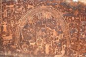
s (millingstones), and weaponry have been found along the Muddy and Ivie Creeks. Coil pottery which is most often used to identify archaeological sites as Fremont. This pottery is not very different from that made by other Southwestern groups, nor is its vessel forms and designs distinct. What distinguishes Fremont pottery from other ceramic types is the material from which it is constructed. Variations in temper, the granular rock or sand added to wet clay to insure even drying and to prevent cracking, have been used to identify five major Fremont ceramic types. They include Snake Valley gray in the southwestern part of the Fremont region, Sevier gray in the central area, Great Salt Lake gray in the northwestern area, and Uinta and Emery gray in the northeast and southwestern regions. Sevier, Snake Valley, and Emery gray also occur in painted varieties. A unique and beautiful painted bowl form, Ivie Creek black-on-white, is found along either side of the southern Wasatch Plateau. In addition to these five major types found at Fremont villages, a variety of locally made pottery wares are found on the fringes of the Fremont region in areas occupied by people who seem to have been principally hunters and gatherers rather than farmers. The Rochester Rock Art Panel
three miles west of Emery is a significant rock art panel left by the Fremont People and has been the target of vandalism and relic thieves.
The earliest known entrance into the region known as Castle Valley by Europeans dates back to the Spanish explorers. The oldest names in Emery County are Spanish, not Native American — San Rafael, Sinbad, and probably Castle Valley itself, are landmarks of that era when Spanish padres, Spanish American explorers, fur traders, trappers, and frontiersmen followed the Old Spanish Trail
through Emery. From about 1776 to the mid-1850s the Old Spanish Trail came up from Santa Fe
, New Mexico
, crossed the Colorado River
at Moab, over the Green River
where Green River City now stands, across the San Rafael desert into Castle Valley, then crossed along the eastern part of the town. This became the established route of the Spanish Slave Traders who captured indigenous people along the route and were selling them as slaves.
 A sizable herd of wild horses are managed east of Emery. These wild horses and burros have occupied the San Rafael Swell
area since the beginning of the Old Spanish Trail in the early 19th century. Early travelers would lose animals or have them run off by Indians or rustlers. Many of these animals were headed for California to be traded and sold and were of good stock. The herd was also augmented through the release of domestic horses from local ranches. By the early 20th century, wild horse and burro numbers had soared and were being captured and sold by local mustang
ers. This continued until the passage of the Wild and Free-Roaming Horses and Burros Act of 1971
. Since the passage of this act, the horses and burros have been managed under federal law and Bureau regulation.
In the summer of 1853 Captain John W. Gunnison
was sent by the War Department of the United States to explore a railroad route to the Pacific Coast. He was assisted by Lt. E. G. Beckwith. They entered Castle Valley passed near the town in October, 1853. Gunnison described the area as follows: Except three or four small cottonwood trees, there is not a tree to be seen by the unassisted eye on any part of the horizon. The plain lying between us and the Wasatch Range, one hundred miles to the west, is a series of rocky, parallel chasms, and fantastic sandstone ridges. On the north, Roan Cliffs, ten miles from us, present bare masses miles back, a few scattering cedars may be distinguished with the glass. The surface around is whitened with fields of alkali resembling fields of snow. 'Unless this interior country possesses undiscovered minerals of great value, it can contribute but the merest trifle towards the maintenance of a railroad through it after it has been constructed.”
 The first settlers to Emery came from Sanpete County, Utah
. This is unusually notable as the settlers headed east, instead of west (like most settlers at the time), even if it was over a mountain range. The first attempt at settlement was made at Muddy Creek. The Muddy Creek is a stream following down a wide canyon, and eventually emptying into the Dirty Devil River. The Muddy Creek vegetation included tall grass, sage, greasewood, rabbit brush, tender shadscale or Castle Valley clover, prickly pear cacti, and yucca. Growing along the creek banks were giant cottonwood trees and patches of huge thorny bushes with long needle sharp spines called bull berry bushes. These berries, when beaten off onto a canvas could be dried, made into jams, jellies, or even eaten raw.
Among these early settlers were Charles Johnson, Marenus and Joseph Lund families. Casper Christensen and Fred Acord also brought their families and began to build cabins and plant crops. Joseph Lund, the first to build a small one room log cabin with a lean-to, became discouraged and left it for Casper Christensen (this building still survives and has been restored and relocated to This Is The Place Heritage Park
in Salt Lake City). Most travel came by way of Salina Canyon and Spring Canyon, which weren't much more than deer trails. Roads were bad at best and almost impassable most of the time. The modes of travel were by horseback, team and wagon, or on snowshoes in winter time.
Another company settled farther up the canyon around this same date—families who came from Beaver, Mayfield, and Sterling. They called themselves "The Beaver Brothers." Among these were Dan, Miles, and Samuel Miller, George Collier, Samuel Babbett and others. Some of these became discouraged and left the first year. The Millers moved farther down the lower part of the Muddy Creek canyon. This part has been called Miller's Canyon ever since that time.
Several miles south, on Quitchupah Creek
, several families were trying to homestead on land that was more barren than Muddy Creek. In the 1870s, Brigham Young
called on several families from Sanpete County to settle on Muddy Creek. Most of the first homes on Muddy Creek were called a Dugout (shelter)
. It was a room dug in the side of a hill or the bank of a wash. The front was very crude, sometimes the only door being a blanket hung over the opening, or a rough wooden door, hung with leather hinges. The windows were small openings made in the front wall and covered with heavy greased paper or white canvas. Each had a fireplace in one end, which served for heat, cook¬ing and light. The heat from the fire made the dugout unbearably hot in summer, so then the cooking was done on an open fire outside. The roof of the dugout was made of poles, covered with willows and dirt. These roofs served well in dry weather, as they were warm and kept out the wind. However, they leaked badly in stormy weather. Another great inconvenience of these roofs was the fact that they were a home for snakes, rats, mice and spiders. The floors were usually dirt or sometimes rock.
During the years from 1882 to 1885 quite a number of families moved into the Muddy Creek area. A few of them were: Jedediah Knight, Joseph Nielson, Pleasant Minchey, Frank Foote, Charley and Ammon Foote, George Merrick, Oscar Beebe, Orson Davis, Heber C. K. Petty, Sr., Joseph Evans, Rasmus Johnson, Carl Magnus Olsen, Peter Nielson, Peter Hansen, Heber Broderick, Peter Christensen, George A. Whitlock, Peter Victor Bunderson, Rasmus Albrechtson, Christian A. Larsen, Lafe Allred, Hyrum Strong, Peter Jensen, Isaac Kimball, William George Petty, Niels Jensen, Wiley Payne Allred, Andrew C. Anderson, Stephen Williams and David Pratt. Most of these families were Danish immigrants. By 1885, it was determined that the canyon itself was not wide enough for many farms and that more fertile land lie to the south of the Muddy.
The settling of this land, required bringing the waters of Muddy Creek through a tunnel that took nearly three years to dig. With no trained engineering assistance, the settlers made their calculations, started from opposite sides of the hill, dodged numerous cave-ins of the treacherous Mancos shale, maintained the correct level inside the tunnel and connected both tunnels nearly perfectly.
The year of 1883 was a red letter year for Casper Christensen. On April 15 he was set apart as the Presiding Elder of the Muddy Creek Branch of the Church of Jesus Christ of Latter-day Saints. On the 26th of August his daughter, Bellette, was born, the first baby girl to be born on the Muddy Creek. September 2 the Emery Ward was organized with Casper Christensen as Bishop. Then on November 19 he was officially appointed Postmaster at Muddy, in the County of Emery in the Utah Territory. His daughter, Hannah, was appointed as his assistant.
When Casper Christensen was first appointed postmaster and Bishop, a postal inspector found him working in the field and tried to make him understand that he wanted to inspect his postal records. Finally in desperation he said, "You don't seem to know who I am. I am a postal inspector." Brother Casper indignantly replied, "And YOU don't know who I am. I'm the Bishop on the Creek!" Town residents have continued to use this phrase when dealing with someone who was self-important.
Muddy Creek and Quitchupah residents consolidated on this new townsite. Log cabins were built as soon as logs could be hauled from the nearby mountains. The logs were smoothed on one side with grooves chopped in each end. They were then placed on top of each other with the smooth side facing inward. Chinks between the logs were filled with mud or clay. Willows were used for lath, nailed to the logs and plastered with mud. This mud was then rubbed smooth and painted with a whitewash of lime. The roofs were made of rough lumber, and covered with a layer of straw or brush and then a top layer of dirt. Later the roofs were greatly improved when cedar shingles became available.
The town of Muddy would later change to Emery, after Governor George W. Emery
. However, both names would be synonymously used. Emery has always been an agricultural community. Ranching and farming is its major livelihood. The town would swell in population to have its own school, but after World War II, the population has decreased due to lack of economic opportunities and has generally hovered around 300 residents. The discovery of coal, south of the town, lead to several mines being developed, and the idea that the town could once again draw in new residents. However, with the decrease in coal prices, production has not required the initiation of new mining operations.
On November 2, 1967, the Last Chance Motel was destroyed by a cone-shaped F2 tornado. Furniture and bedding were thrown hundreds of yards. The tornado occurred at the unusual time of 5:30 am and no injuries were reported.
According to the United States Census Bureau
, the town has a total area of 1.2 square miles (3.1 km²).
of 2000, there were 308 people, 123 households, and 89 families residing in the town. The population density
was 253.7 people per square mile (98.3/km²). There were 140 housing units at an average density of 115.3 per square mile (44.7/km²). The racial makeup of the town was 97.73% White, 0.97% Native American, and 1.30% from two or more races. Hispanic or Latino of any race were 0.97% of the population.
There were 123 households out of which 29.3% had children under the age of 18 living with them, 61.0% were married couples
living together, 6.5% had a female householder with no husband present, and 27.6% were non-families. 26.8% of all households were made up of individuals and 12.2% had someone living alone who was 65 years of age or older. The average household size was 2.50 and the average family size was 3.03.
 In the town the population was spread out with 28.9% under the age of 18, 5.8% from 18 to 24, 19.2% from 25 to 44, 24.4% from 45 to 64, and 21.8% who were 65 years of age or older. The median age was 43 years. For every 100 females there were 98.7 males. For every 100 females age 18 and over, there were 97.3 males.
The median income for a household in the town was $40,469, and the median income for a family was $51,875. Males had a median income of $40,104 versus $31,250 for females. The per capita income
for the town was $17,195. About 12.1% of families and 13.1% of the population were below the poverty line, including 14.3% of those under the age of eighteen and 19.3% of those sixty five or over.
Emery County, Utah
Emery County is a county located in the U.S. state of Utah. As of 2000 the population was 10,860, and by 2009 had been estimated to decrease to 10,629. It was named for George W. Emery, governor of the Utah Territory in 1875...
, Utah
Utah
Utah is a state in the Western United States. It was the 45th state to join the Union, on January 4, 1896. Approximately 80% of Utah's 2,763,885 people live along the Wasatch Front, centering on Salt Lake City. This leaves vast expanses of the state nearly uninhabited, making the population the...
, United States
United States
The United States of America is a federal constitutional republic comprising fifty states and a federal district...
. The population was 308 at the 2000 census.
Prehistoric
Emery sits at the base of the mountains that contain the North Horn Formation. Named after North Horn Mountain, near Castle Dale, UtahCastle Dale, Utah
Castle Dale is a city in Emery County, Utah, United States. The population was 1,657 at the 2000 census. It is the county seat of Emery County.-History:...
this formation in Emery County contain numerous Cretaceous
Cretaceous
The Cretaceous , derived from the Latin "creta" , usually abbreviated K for its German translation Kreide , is a geologic period and system from circa to million years ago. In the geologic timescale, the Cretaceous follows the Jurassic period and is followed by the Paleogene period of the...
-Tertiary
Tertiary
The Tertiary is a deprecated term for a geologic period 65 million to 2.6 million years ago. The Tertiary covered the time span between the superseded Secondary period and the Quaternary...
Era fossil
Fossil
Fossils are the preserved remains or traces of animals , plants, and other organisms from the remote past...
invertebrates, microfossils and palynomorph
Palynomorph
Palynomorph is the geological term used to describe a particle of a size between five and 500 micrometres, found in rock deposits and composed of organic material such as chitin, pseudochitin and sporopollenin...
s. Flagstaff Peak, north of Emery, has abundant dinosaur bone material and pre-historic mammal remains and petrified dinosaur footprints.
Fremont People, the Old Spanish Trail, and Exploration
The Fremont cultureFremont culture
The Fremont culture or Fremont people is a pre-Columbian archaeological culture which received its name from the Fremont River in the U.S. state of Utah where the first Fremont sites were discovered. The Fremont River itself is named for John Charles Frémont, an American explorer. It inhabited...
or Fremont people is a pre-Columbian
Pre-Columbian
The pre-Columbian era incorporates all period subdivisions in the history and prehistory of the Americas before the appearance of significant European influences on the American continents, spanning the time of the original settlement in the Upper Paleolithic period to European colonization during...
archeological culture who existed in the area from AD 700 to 1300. It was adjacent to, roughly contemporaneous with, but distinctly different from the Anasazi culture. The culture received its name from the Fremont River, where the first Fremont sites were discovered. The Fremont River in Utah flows from the Johnson Valley Reservoir near Fish Lake, Utah southwest through Capitol Reef National Park to the Muddy Creek (Utah)
Muddy Creek (Utah)
Muddy Creek is a stream which drains portions of Emery and Wayne Counties in central Utah, in the western United States. It begins on the eastern slopes of the Wasatch Plateau at elevations above 10,500 feet . It turns southward near the town of Emery, then southeastward where it crosses under...
whose headwaters begin just north of Emery.
Metate
A metate is a mortar, a ground stone tool used for processing grain and seeds. In traditional Mesoamerican culture, metates were typically used by women who would grind calcified maize and other organic materials during food preparation...
s (millingstones), and weaponry have been found along the Muddy and Ivie Creeks. Coil pottery which is most often used to identify archaeological sites as Fremont. This pottery is not very different from that made by other Southwestern groups, nor is its vessel forms and designs distinct. What distinguishes Fremont pottery from other ceramic types is the material from which it is constructed. Variations in temper, the granular rock or sand added to wet clay to insure even drying and to prevent cracking, have been used to identify five major Fremont ceramic types. They include Snake Valley gray in the southwestern part of the Fremont region, Sevier gray in the central area, Great Salt Lake gray in the northwestern area, and Uinta and Emery gray in the northeast and southwestern regions. Sevier, Snake Valley, and Emery gray also occur in painted varieties. A unique and beautiful painted bowl form, Ivie Creek black-on-white, is found along either side of the southern Wasatch Plateau. In addition to these five major types found at Fremont villages, a variety of locally made pottery wares are found on the fringes of the Fremont region in areas occupied by people who seem to have been principally hunters and gatherers rather than farmers. The Rochester Rock Art Panel
Rochester Rock Art Panel
The Rochester Rock Art Panel consists of a large number of petroglyphs of various ages. Some are prehistoric rock art, probably of Fremont culture origin. Others are probably modern, depicting horses, for example. And some are arguably of very recent origin, most likely the work of white...
three miles west of Emery is a significant rock art panel left by the Fremont People and has been the target of vandalism and relic thieves.
The earliest known entrance into the region known as Castle Valley by Europeans dates back to the Spanish explorers. The oldest names in Emery County are Spanish, not Native American — San Rafael, Sinbad, and probably Castle Valley itself, are landmarks of that era when Spanish padres, Spanish American explorers, fur traders, trappers, and frontiersmen followed the Old Spanish Trail
Old Spanish Trail
Old Spanish Trail may refer to:*Old Spanish Trail , connecting Santa Fe, New Mexico with Los Angeles, California in the 19th century...
through Emery. From about 1776 to the mid-1850s the Old Spanish Trail came up from Santa Fe
Santa Fe, New Mexico
Santa Fe is the capital of the U.S. state of New Mexico. It is the fourth-largest city in the state and is the seat of . Santa Fe had a population of 67,947 in the 2010 census...
, New Mexico
New Mexico
New Mexico is a state located in the southwest and western regions of the United States. New Mexico is also usually considered one of the Mountain States. With a population density of 16 per square mile, New Mexico is the sixth-most sparsely inhabited U.S...
, crossed the Colorado River
Colorado River
The Colorado River , is a river in the Southwestern United States and northwestern Mexico, approximately long, draining a part of the arid regions on the western slope of the Rocky Mountains. The watershed of the Colorado River covers in parts of seven U.S. states and two Mexican states...
at Moab, over the Green River
Green River (Utah)
The Green River, located in the western United States, is the chief tributary of the Colorado River. The watershed of the river, known as the Green River Basin, covers parts of Wyoming, Utah, and Colorado. The Green River is long, beginning in the Wind River Mountains of Wyoming and flowing...
where Green River City now stands, across the San Rafael desert into Castle Valley, then crossed along the eastern part of the town. This became the established route of the Spanish Slave Traders who captured indigenous people along the route and were selling them as slaves.
San Rafael Swell
The San Rafael Swell is a large geologic feature located in south-central Utah, USA about 30 miles west of Green River, Utah. The San Rafael Swell, approximately by , consists of a giant dome-shaped anticline of sandstone, shale, and limestone that was pushed up during the Paleocene Laramide...
area since the beginning of the Old Spanish Trail in the early 19th century. Early travelers would lose animals or have them run off by Indians or rustlers. Many of these animals were headed for California to be traded and sold and were of good stock. The herd was also augmented through the release of domestic horses from local ranches. By the early 20th century, wild horse and burro numbers had soared and were being captured and sold by local mustang
Mustang (horse)
A Mustang is a free-roaming horse of the North American west that first descended from horses brought to the Americas by the Spanish. Mustangs are often referred to as wild horses, but there is intense debate over terminology...
ers. This continued until the passage of the Wild and Free-Roaming Horses and Burros Act of 1971
Wild and Free-Roaming Horses and Burros Act of 1971
The Wild and Free-Roaming Horses and Burros Act of 1971 , is an Act of Congress , signed into law President Richard M. Nixon on December 18, 1971...
. Since the passage of this act, the horses and burros have been managed under federal law and Bureau regulation.
In the summer of 1853 Captain John W. Gunnison
John W. Gunnison
John Williams Gunnison was an American military officer and explorer.-Biography:Gunnison was born in Goshen, New Hampshire in 1812. He graduated from West Point in 1837, second in his class of fifty cadets. His military career began in Florida, where he spent a year in the campaign against the...
was sent by the War Department of the United States to explore a railroad route to the Pacific Coast. He was assisted by Lt. E. G. Beckwith. They entered Castle Valley passed near the town in October, 1853. Gunnison described the area as follows: Except three or four small cottonwood trees, there is not a tree to be seen by the unassisted eye on any part of the horizon. The plain lying between us and the Wasatch Range, one hundred miles to the west, is a series of rocky, parallel chasms, and fantastic sandstone ridges. On the north, Roan Cliffs, ten miles from us, present bare masses miles back, a few scattering cedars may be distinguished with the glass. The surface around is whitened with fields of alkali resembling fields of snow. 'Unless this interior country possesses undiscovered minerals of great value, it can contribute but the merest trifle towards the maintenance of a railroad through it after it has been constructed.”
Settlement
Sanpete County, Utah
Sanpete County is a county located in the U.S. state of Utah. The population according to the 2010 U.S. Census was 27,822. It was possibly named for a Ute Indian chief named Sanpitch, which was corrupted to Sanpete. Its county seat is Manti and its largest city is Ephraim.-Geography:According to...
. This is unusually notable as the settlers headed east, instead of west (like most settlers at the time), even if it was over a mountain range. The first attempt at settlement was made at Muddy Creek. The Muddy Creek is a stream following down a wide canyon, and eventually emptying into the Dirty Devil River. The Muddy Creek vegetation included tall grass, sage, greasewood, rabbit brush, tender shadscale or Castle Valley clover, prickly pear cacti, and yucca. Growing along the creek banks were giant cottonwood trees and patches of huge thorny bushes with long needle sharp spines called bull berry bushes. These berries, when beaten off onto a canvas could be dried, made into jams, jellies, or even eaten raw.
Among these early settlers were Charles Johnson, Marenus and Joseph Lund families. Casper Christensen and Fred Acord also brought their families and began to build cabins and plant crops. Joseph Lund, the first to build a small one room log cabin with a lean-to, became discouraged and left it for Casper Christensen (this building still survives and has been restored and relocated to This Is The Place Heritage Park
This Is The Place Heritage Park
The This Is the Place Heritage Park is located on the east side of Salt Lake City, Utah, USA at the foot of the Wasatch Range and near the mouth of Emigration Canyon.-History:...
in Salt Lake City). Most travel came by way of Salina Canyon and Spring Canyon, which weren't much more than deer trails. Roads were bad at best and almost impassable most of the time. The modes of travel were by horseback, team and wagon, or on snowshoes in winter time.
Another company settled farther up the canyon around this same date—families who came from Beaver, Mayfield, and Sterling. They called themselves "The Beaver Brothers." Among these were Dan, Miles, and Samuel Miller, George Collier, Samuel Babbett and others. Some of these became discouraged and left the first year. The Millers moved farther down the lower part of the Muddy Creek canyon. This part has been called Miller's Canyon ever since that time.
Several miles south, on Quitchupah Creek
Quitchupah Creek
Quitchupah Creek is a stream draining portions of Emery and Sevier Counties in central Utah, in the western United States. Quitchupah Creek is significant for its rock art remains of the Fremont culture that line its banks...
, several families were trying to homestead on land that was more barren than Muddy Creek. In the 1870s, Brigham Young
Brigham Young
Brigham Young was an American leader in the Latter Day Saint movement and a settler of the Western United States. He was the President of The Church of Jesus Christ of Latter-day Saints from 1847 until his death in 1877, he founded Salt Lake City, and he served as the first governor of the Utah...
called on several families from Sanpete County to settle on Muddy Creek. Most of the first homes on Muddy Creek were called a Dugout (shelter)
Dugout (shelter)
A dugout or dug-out, also known as a pithouse, pit-house, earth lodge, mud hut, is a shelter for humans or domesticated animals and livestock based on a hole or depression dug into the ground. These structures are one of the most ancient types of human housing known to archeologists...
. It was a room dug in the side of a hill or the bank of a wash. The front was very crude, sometimes the only door being a blanket hung over the opening, or a rough wooden door, hung with leather hinges. The windows were small openings made in the front wall and covered with heavy greased paper or white canvas. Each had a fireplace in one end, which served for heat, cook¬ing and light. The heat from the fire made the dugout unbearably hot in summer, so then the cooking was done on an open fire outside. The roof of the dugout was made of poles, covered with willows and dirt. These roofs served well in dry weather, as they were warm and kept out the wind. However, they leaked badly in stormy weather. Another great inconvenience of these roofs was the fact that they were a home for snakes, rats, mice and spiders. The floors were usually dirt or sometimes rock.
During the years from 1882 to 1885 quite a number of families moved into the Muddy Creek area. A few of them were: Jedediah Knight, Joseph Nielson, Pleasant Minchey, Frank Foote, Charley and Ammon Foote, George Merrick, Oscar Beebe, Orson Davis, Heber C. K. Petty, Sr., Joseph Evans, Rasmus Johnson, Carl Magnus Olsen, Peter Nielson, Peter Hansen, Heber Broderick, Peter Christensen, George A. Whitlock, Peter Victor Bunderson, Rasmus Albrechtson, Christian A. Larsen, Lafe Allred, Hyrum Strong, Peter Jensen, Isaac Kimball, William George Petty, Niels Jensen, Wiley Payne Allred, Andrew C. Anderson, Stephen Williams and David Pratt. Most of these families were Danish immigrants. By 1885, it was determined that the canyon itself was not wide enough for many farms and that more fertile land lie to the south of the Muddy.
The settling of this land, required bringing the waters of Muddy Creek through a tunnel that took nearly three years to dig. With no trained engineering assistance, the settlers made their calculations, started from opposite sides of the hill, dodged numerous cave-ins of the treacherous Mancos shale, maintained the correct level inside the tunnel and connected both tunnels nearly perfectly.
The year of 1883 was a red letter year for Casper Christensen. On April 15 he was set apart as the Presiding Elder of the Muddy Creek Branch of the Church of Jesus Christ of Latter-day Saints. On the 26th of August his daughter, Bellette, was born, the first baby girl to be born on the Muddy Creek. September 2 the Emery Ward was organized with Casper Christensen as Bishop. Then on November 19 he was officially appointed Postmaster at Muddy, in the County of Emery in the Utah Territory. His daughter, Hannah, was appointed as his assistant.
When Casper Christensen was first appointed postmaster and Bishop, a postal inspector found him working in the field and tried to make him understand that he wanted to inspect his postal records. Finally in desperation he said, "You don't seem to know who I am. I am a postal inspector." Brother Casper indignantly replied, "And YOU don't know who I am. I'm the Bishop on the Creek!" Town residents have continued to use this phrase when dealing with someone who was self-important.
Muddy Creek and Quitchupah residents consolidated on this new townsite. Log cabins were built as soon as logs could be hauled from the nearby mountains. The logs were smoothed on one side with grooves chopped in each end. They were then placed on top of each other with the smooth side facing inward. Chinks between the logs were filled with mud or clay. Willows were used for lath, nailed to the logs and plastered with mud. This mud was then rubbed smooth and painted with a whitewash of lime. The roofs were made of rough lumber, and covered with a layer of straw or brush and then a top layer of dirt. Later the roofs were greatly improved when cedar shingles became available.
The town of Muddy would later change to Emery, after Governor George W. Emery
George W. Emery
George W. Emery was the eleventh governor of Utah Territory. Emery was appointed by President Ulysses S. Grant for Supervisor of Internal Revenue for the confederate states from 1870 to 1874 and governor in 1875. After his term ended in 1880, the Utah Legislature named Emery County, Utah in...
. However, both names would be synonymously used. Emery has always been an agricultural community. Ranching and farming is its major livelihood. The town would swell in population to have its own school, but after World War II, the population has decreased due to lack of economic opportunities and has generally hovered around 300 residents. The discovery of coal, south of the town, lead to several mines being developed, and the idea that the town could once again draw in new residents. However, with the decrease in coal prices, production has not required the initiation of new mining operations.
On November 2, 1967, the Last Chance Motel was destroyed by a cone-shaped F2 tornado. Furniture and bedding were thrown hundreds of yards. The tornado occurred at the unusual time of 5:30 am and no injuries were reported.
Geography & Climate
Emery is located at 38°55′20"N 111°14′58"W (38.922337, -111.249366).According to the United States Census Bureau
United States Census Bureau
The United States Census Bureau is the government agency that is responsible for the United States Census. It also gathers other national demographic and economic data...
, the town has a total area of 1.2 square miles (3.1 km²).
Demographics
As of the censusCensus
A census is the procedure of systematically acquiring and recording information about the members of a given population. It is a regularly occurring and official count of a particular population. The term is used mostly in connection with national population and housing censuses; other common...
of 2000, there were 308 people, 123 households, and 89 families residing in the town. The population density
Population density
Population density is a measurement of population per unit area or unit volume. It is frequently applied to living organisms, and particularly to humans...
was 253.7 people per square mile (98.3/km²). There were 140 housing units at an average density of 115.3 per square mile (44.7/km²). The racial makeup of the town was 97.73% White, 0.97% Native American, and 1.30% from two or more races. Hispanic or Latino of any race were 0.97% of the population.
There were 123 households out of which 29.3% had children under the age of 18 living with them, 61.0% were married couples
Marriage
Marriage is a social union or legal contract between people that creates kinship. It is an institution in which interpersonal relationships, usually intimate and sexual, are acknowledged in a variety of ways, depending on the culture or subculture in which it is found...
living together, 6.5% had a female householder with no husband present, and 27.6% were non-families. 26.8% of all households were made up of individuals and 12.2% had someone living alone who was 65 years of age or older. The average household size was 2.50 and the average family size was 3.03.
The median income for a household in the town was $40,469, and the median income for a family was $51,875. Males had a median income of $40,104 versus $31,250 for females. The per capita income
Per capita income
Per capita income or income per person is a measure of mean income within an economic aggregate, such as a country or city. It is calculated by taking a measure of all sources of income in the aggregate and dividing it by the total population...
for the town was $17,195. About 12.1% of families and 13.1% of the population were below the poverty line, including 14.3% of those under the age of eighteen and 19.3% of those sixty five or over.
External links
- Emery Town at EmeryCounty.com