
Monticello, Utah
Encyclopedia
Monticello is a city located in San Juan County
, Utah
, and is the county seat
. It is the second most populous city in San Juan County, with a population of 1,958 at the 2000 census. The Monticello area was settled in July 1887 by pioneers from The Church of Jesus Christ of Latter-day Saints. Monticello, named in honor of Thomas Jefferson's
estate
, became the county seat in 1895 and was incorporated as a city in 1910.
Monticello, along with much of San Juan County, experienced an increase in population and economic activity during the uranium
boom from the late 1940s to the early 1960s. Several uranium and vanadium mines were opened in the area, and a uranium processing mill was operated in Monticello by the Federal Government from 1948 to 1960. Following the uranium boom, a massive cleanup project was conducted by the U.S. Department of Energy from 1989 to 2004 to remove radioactive material from lands and buildings and to restore the land formerly occupied by the mill.
An 18-hole golf course, The Hideout
, was built near the reclaimed site of the uranium mill using DOE cleanup funding in 2000. The Hideout has been ranked No. 2 Golf Course in Utah and the No. 23 Municipal Golf Course in the U.S.
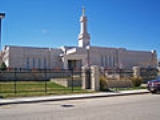
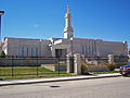
In 1998, The Church of Jesus Christ of Latter-day Saints dedicated the Monticello Utah Temple
, the first in a series of mini temples
and the 53rd temple for the Church.
Monticello rests at the base of the Abajo Mountains
on the Colorado Plateau
.
, which became the State of Utah
. Farming, ranching, and uranium mining have all played an important role in the economy and history of the town.
, Utah
. Few white residents had settled along the San Juan River prior to the arrival of the Mormon pioneers from the San Juan Expedition
. After passing through Hole-In-The-Rock, the pioneers arrived in the San Juan County area and settled in Bluff
on 6 April 1880. In that year, on a journey to northern Utah from the San Juan River settlements, Apostles Erastus Snow and Brigham Young, Jr. passed through the current site of Monticello. They were quite impressed by it, and this encounter was one of the key factors behind LDS settlement there a few years later. After struggling to farm along the unpredictable San Juan River, leaders began to look to settle the higher country at the base of the Abajo Mountains, also known as the Blue Mountains, where several streams and springs descended from the mountain. Piute Springs, Solder’s Spring, and Montezuma Creek were a few of the water sources in the area named by passersby.
In March 1886, Francis A. Hammond, the LDS Stake President (the leading LDS regional authority) of San Juan County, sent scouts from Bluff to identify possible locations for settlements near the water sources of the Blue Mountains. The scouts found that a few people had already begun to utilize the land. The first white man to build a cabin in the Monticello area was likely cattleman Patrick O'Donnell in 1879. The North and South Forks of Montezuma Canyon, through which Montezuma Creek flows, were being utilized when the scouts arrived. The Kansas and New Mexico Cattle and Land Company, operated by Edmund and Harold Carlisle, was located a few miles north of what is now Monticello, and the L.C. outfit was headquartered in the South Fork of Montezuma Canyon.
Notwithstanding the fact that others were utilizing the land, Hammond sent the families of George A. Adams, Frederick I. Jones, Parley R. Butt and Charles E. Walton from Bluff to establish a new settlement at what is now Monticello. They first set up camp at Verdure near the South Fork of Montezuma Creek on March 11, 1887, six miles (10 km) south of what is now Monticello. By the first part of July, 1887, the men had begun to plant crops, survey an irrigation ditch, and layout a town site in the present-day Monticello area. Conflicts soon began with the Carlisle cowboys and Ute Indians over water and land rights, resulting in warning shots, heated disputes, and legal battles.
Learning from lawyers that the Carlisles had very little legal claim to any of the region, the Mormons claimed all the water from the South Fork and three-fourths of the water from the North Fork. In the spring of 1888, the Adams and Butt families remained in Verdure while the rest of the settlers moved to North Montezuma and began construction of the town.
Early names for the settlement were North Montezuma Creek, Piute Springs, and Hammond, after the stake president. In a formal meeting in 1888, three names were under consideration: North Montezuma, Hammond, and the biblical name, Antioch. None of the names were approved by the younger members of the community. When Hammond recommended Monticello, in honor of Thomas Jefferson’s estate, everyone approved and it was accepted.
The first phone lines were installed in the community in 1906, tying into Colorado circuits. The Blue Mountain Irrigation Company organized construction of a combined water and power system in 1917. The San Juan Record, the county newspaper, was established in Monticello by Oscar Walter McConkie in 1915, where it remains to this day.
 The Vanadium Corporation of America (VCA) began construction of a vanadium
mill in Monticello in 1941 in response to the increased demand for radioactive material brought about by World War II
. In 1943, VCA began producing a uranium-vanadium sludge for the Manhattan Engineer District
. It employed 200 workers until it closed in 1946. In 1948, the U.S. Federal Government purchased the mill and reopened it in 1949 as a converted uranium and vanadium processing plant.
Monticello and the San Juan County area experienced significant growth during the uranium boom of the 1950s. The uranium mines in San Juan County were among the richest in the nation. The Happy Jack Mine, located in White Canyon, San Juan County, was founded by Monticello natives Fletch Bronson and Joe Cooper. The Happy Jack Mine was the second richest deposit of high grade uranium ore in the nation, the first being the MiVida Mine, also in San Juan County. During these years the mill at Monticello processed large amounts of ore taken from the canyons of southeastern Utah. The population of Monticello more than doubled during this time as a result of the activity at the processing plant and the mining activity in the region. County assessed valuation jumped from $1 million in the 1940s to $132 million in 1959. Oil and mining accounted for 94 percent of the property tax in San Juan County during those years, and the San Juan School District became the state's highest paying district.
Demand for uranium subsided in the early 1960s. On Jan. 1, 1960, the mill was closed permanently by the Atomic Energy Commission. The mill tailings were stabilized by 1962, and the mill was dismantled in 1964.
A massive cleanup project was conducted by the U.S. Department of Energy from 1989 to 2004 to remove radioactive material from lands and buildings and to restore the land formerly occupied by the mill. All radioactive material was removed and placed in a controlled repository near Monticello. Funding was provided to restore the former mill site and roughly 150 acre (0.607029 km²) of surrounding land to a usable condition. In a deal with the Federal Government, the City of Monticello reseeded and restored the reclaimed land; upon completion, the city received roughly $7 million from the government.
With the remaining cleanup funds, the city decided to expand the existing 9-hole golf course into an 18-hole course. The course site is adjacent to the mill site. Long time resident Rex Jensen donated land to the city to be used for expanding the course towards the mountain. The course was designed by Forrest Richardson & Assoc. Golf Course Architects, and construction was completed in 2001.
Many Monticello residents claim that the exposure to the radioactive mill tailings caused cancer
in residents and mill workers. Efforts have been made and are ongoing to secure compensation for the illness or death of family members exposed to the mill tailings. In 2009, legislation was passed to provide free cancer screening to residents who lived in Monticello between 1941 and 2000.
.
According to the United States Census Bureau
, the city has a total area of 2.6 square miles (6.7 km²), all land, making it the largest city in the county in terms of area.
Monticello is located at the base of the Abajo Mountains
, or the Blue Mountains, which are part of the Manti-La Sal National Forest
. The elevation of Monticello is 7069 feet (2,154.6 m). From Monticello, a tree formation on the Blue Mountains can be seen, which resembles a horse's head and neck. Locals claim that the "horsehead," as it is called, can be seen from any point in town.
Monticello is 40 miles from the Needles District of Canyonlands National Park
and is 59 miles from Arches National Park
, located near Moab
.
of 2000, there were 1,958 people, 606 households, and 467 families residing in the city. The population density
was 757.1 people per square mile (291.9/km²). There were 717 housing units at an average density of 277.2 per square mile (106.9/km²). The racial makeup of the city was 83.09% White, 0.10% African American, 6.44% Native American, 0.87% Asian, 0.15% Pacific Islander, 7.00% from other races
, and 2.35% from two or more races. Hispanic or Latino of any race were 13.69% of the population.
There were 606 households out of which 41.9% had children under the age of 18 living with them, 69.0% were married couples
living together, 5.8% had a female householder with no husband present, and 22.8% were non-families. 20.8% of all households were made up of individuals and 9.4% had someone living alone who was 65 years of age or older. The average household size was 3.09 and the average family size was 3.65.
In the city the population was spread out with 36.5% under the age of 18, 7.6% from 18 to 24, 25.7% from 25 to 44, 17.9% from 45 to 64, and 12.3% who were 65 years of age or older. The median age was 30 years. For every 100 females there were 110.3 males. For every 100 females age 18 and over, there were 108.7 males.
The median income for a household in the city was $35,929, and the median income for a family was $42,115. Males had a median income of $31,000 versus $21,875 for females. The per capita income
for the city was $14,033. About 6.7% of families and 8.2% of the population were below the poverty line, including 8.1% of those under age 18 and 6.3% of those age 65 or over.
 As the seat of San Juan County, Monticello is home to the San Juan County Fair and Fairgrounds. The annual fair usually occurs during August. A 24 July Parade and Celebration are also held annually in Monticello to commemorate Pioneer Day, a Utah holiday commemorating the arrival of Mormon settlers to the Salt Lake Valley
.
Blue Mountain Entertainment is a local arts organization which provides funding to bring cultural performances to Monticello throughout the year.
The City of Monticello annually hosts the Blue Mountain Triathlon. The 27 miles (43.5 km) race begins with 4 miles (6.4 km) of cross country skiing on the Blue Mountain, followed by an 18 miles (29 km) bike ride, and ending with a 5 miles (8 km) run past Newspaper Rock.
On October 4, 1997, President Gordon B. Hinckley
, President of The Church of Jesus Christ of Latter-day Saints, announced that the Church would begin to build a new series of "miniature temples." The first of such temples was built in Monticello. Groundbreaking began on November 17, 1997. An open house was held from July 15 to July 18, 1998, and the Monticello Utah Temple
was dedicated July 26, 1998. The temple was subsequently expanded and rededicated on November 17, 2002. The Monticello Temple was the 53rd temple
completed by the Church.
. The San Juan County Library is located in Monticello.
Monticello was selected as the site for an extension of the George Wythe University
; groundbreaking for the new facility took place in August 2008 but the project was never completed.
, an 18-hole golf course constructed near the reclaimed site of the uranium mill. The Hideout has been ranked No. 2 Golf Course in Utah and the No. 23 Municipal Golf Course in the U.S.
The Abajo Mountains
and surrounding areas offer hiking and hunting. Fishing is available at Foy Lake, Monticello Lake, and Lloyds Lake, all on the Blue Mountains.
San Juan County, Utah
As of the current census of 2010, there were 14,746 people and 4,505 households. The racial and ethnic composition of the population was 50.4% Native American, 45.8% white, 0.3% Asian, 0.2% African American and 2.3% reporting two or more races...
, Utah
Utah
Utah is a state in the Western United States. It was the 45th state to join the Union, on January 4, 1896. Approximately 80% of Utah's 2,763,885 people live along the Wasatch Front, centering on Salt Lake City. This leaves vast expanses of the state nearly uninhabited, making the population the...
, and is the county seat
County seat
A county seat is an administrative center, or seat of government, for a county or civil parish. The term is primarily used in the United States....
. It is the second most populous city in San Juan County, with a population of 1,958 at the 2000 census. The Monticello area was settled in July 1887 by pioneers from The Church of Jesus Christ of Latter-day Saints. Monticello, named in honor of Thomas Jefferson's
Thomas Jefferson
Thomas Jefferson was the principal author of the United States Declaration of Independence and the Statute of Virginia for Religious Freedom , the third President of the United States and founder of the University of Virginia...
estate
Monticello
Monticello is a National Historic Landmark just outside Charlottesville, Virginia, United States. It was the estate of Thomas Jefferson, the principal author of the United States Declaration of Independence, third President of the United States, and founder of the University of Virginia; it is...
, became the county seat in 1895 and was incorporated as a city in 1910.
Monticello, along with much of San Juan County, experienced an increase in population and economic activity during the uranium
Uranium
Uranium is a silvery-white metallic chemical element in the actinide series of the periodic table, with atomic number 92. It is assigned the chemical symbol U. A uranium atom has 92 protons and 92 electrons, of which 6 are valence electrons...
boom from the late 1940s to the early 1960s. Several uranium and vanadium mines were opened in the area, and a uranium processing mill was operated in Monticello by the Federal Government from 1948 to 1960. Following the uranium boom, a massive cleanup project was conducted by the U.S. Department of Energy from 1989 to 2004 to remove radioactive material from lands and buildings and to restore the land formerly occupied by the mill.
An 18-hole golf course, The Hideout
The Hideout Golf Club
The Hideout Golf Club is a public golf course in Monticello, Utah. Golfweek has rated it the "#24 Municipal Course in America". It was opened in 2002 after completion in 2001 by Forrest Richardson. Of note is the fact that nine holes of the course are built on the reclaimed former site of a...
, was built near the reclaimed site of the uranium mill using DOE cleanup funding in 2000. The Hideout has been ranked No. 2 Golf Course in Utah and the No. 23 Municipal Golf Course in the U.S.
In 1998, The Church of Jesus Christ of Latter-day Saints dedicated the Monticello Utah Temple
Monticello Utah Temple
The Monticello Utah Temple is the 53rd operating temple of The Church of Jesus Christ of Latter-day Saints.In October of 1997, LDS Church President Gordon B. Hinckley announced the building of smaller Latter-day Saint Temples throughout the world. The first of these smaller temples was to be built...
, the first in a series of mini temples
Temple (LDS Church)
In The Church of Jesus Christ of Latter-day Saints , a temple is a building dedicated to be a House of the Lord, and they are considered by Church members to be the most sacred structures on earth. Upon completion, temples are usually open to the public for a short period of time...
and the 53rd temple for the Church.
Monticello rests at the base of the Abajo Mountains
Abajo Mountains
The Abajo Mountains, also called the Blue Mountains, is a small mountain range west of Monticello, Utah, south of Canyonlands National Park and north of Blanding, Utah. The mountain range is located within the Manti-La Sal National Forest...
on the Colorado Plateau
Colorado Plateau
The Colorado Plateau, also called the Colorado Plateau Province, is a physiographic region of the Intermontane Plateaus, roughly centered on the Four Corners region of the southwestern United States. The province covers an area of 337,000 km2 within western Colorado, northwestern New Mexico,...
.
History
Monticello was one of the many cities established by Mormon pioneers in the Utah TerritoryUtah Territory
The Territory of Utah was an organized incorporated territory of the United States that existed from September 9, 1850, until January 4, 1896, when the final extent of the territory was admitted to the Union as the State of Utah....
, which became the State of Utah
Utah
Utah is a state in the Western United States. It was the 45th state to join the Union, on January 4, 1896. Approximately 80% of Utah's 2,763,885 people live along the Wasatch Front, centering on Salt Lake City. This leaves vast expanses of the state nearly uninhabited, making the population the...
. Farming, ranching, and uranium mining have all played an important role in the economy and history of the town.
Settlement
Early members of The Church of Jesus Christ of Latter-day Saints, also referred to as Mormons or LDS, began the first full-scale settling of what is now known as San Juan CountySan Juan County, Utah
As of the current census of 2010, there were 14,746 people and 4,505 households. The racial and ethnic composition of the population was 50.4% Native American, 45.8% white, 0.3% Asian, 0.2% African American and 2.3% reporting two or more races...
, Utah
Utah
Utah is a state in the Western United States. It was the 45th state to join the Union, on January 4, 1896. Approximately 80% of Utah's 2,763,885 people live along the Wasatch Front, centering on Salt Lake City. This leaves vast expanses of the state nearly uninhabited, making the population the...
. Few white residents had settled along the San Juan River prior to the arrival of the Mormon pioneers from the San Juan Expedition
San Juan Expedition
right|Route of the San Juan Expedition through UtahThe San Juan Expedition was a group of Mormon settlers intent on establishing a colony in what is now southeastern Utah, in the western United States...
. After passing through Hole-In-The-Rock, the pioneers arrived in the San Juan County area and settled in Bluff
Bluff, Utah
Bluff is a census-designated place in San Juan County, Utah, United States. The population was 320 at the 2000 census.-Geography:Bluff is located at , in the scenic and very sparsely populated southeastern Utah canyonlands of the Colorado Plateau.According to the United States Census Bureau, the...
on 6 April 1880. In that year, on a journey to northern Utah from the San Juan River settlements, Apostles Erastus Snow and Brigham Young, Jr. passed through the current site of Monticello. They were quite impressed by it, and this encounter was one of the key factors behind LDS settlement there a few years later. After struggling to farm along the unpredictable San Juan River, leaders began to look to settle the higher country at the base of the Abajo Mountains, also known as the Blue Mountains, where several streams and springs descended from the mountain. Piute Springs, Solder’s Spring, and Montezuma Creek were a few of the water sources in the area named by passersby.
In March 1886, Francis A. Hammond, the LDS Stake President (the leading LDS regional authority) of San Juan County, sent scouts from Bluff to identify possible locations for settlements near the water sources of the Blue Mountains. The scouts found that a few people had already begun to utilize the land. The first white man to build a cabin in the Monticello area was likely cattleman Patrick O'Donnell in 1879. The North and South Forks of Montezuma Canyon, through which Montezuma Creek flows, were being utilized when the scouts arrived. The Kansas and New Mexico Cattle and Land Company, operated by Edmund and Harold Carlisle, was located a few miles north of what is now Monticello, and the L.C. outfit was headquartered in the South Fork of Montezuma Canyon.
Notwithstanding the fact that others were utilizing the land, Hammond sent the families of George A. Adams, Frederick I. Jones, Parley R. Butt and Charles E. Walton from Bluff to establish a new settlement at what is now Monticello. They first set up camp at Verdure near the South Fork of Montezuma Creek on March 11, 1887, six miles (10 km) south of what is now Monticello. By the first part of July, 1887, the men had begun to plant crops, survey an irrigation ditch, and layout a town site in the present-day Monticello area. Conflicts soon began with the Carlisle cowboys and Ute Indians over water and land rights, resulting in warning shots, heated disputes, and legal battles.
Learning from lawyers that the Carlisles had very little legal claim to any of the region, the Mormons claimed all the water from the South Fork and three-fourths of the water from the North Fork. In the spring of 1888, the Adams and Butt families remained in Verdure while the rest of the settlers moved to North Montezuma and began construction of the town.
Early names for the settlement were North Montezuma Creek, Piute Springs, and Hammond, after the stake president. In a formal meeting in 1888, three names were under consideration: North Montezuma, Hammond, and the biblical name, Antioch. None of the names were approved by the younger members of the community. When Hammond recommended Monticello, in honor of Thomas Jefferson’s estate, everyone approved and it was accepted.
1900 to 1940
In 1903 the Utah State Agricultural College in Logan established an experimental station in Verdure where various dry-farming techniques were tested for thirteen years. This information spurred the growth of the farming industry in the area. In 1909 the Enlarged Homestead Act was passed, which provided 320 acres (1.3 km²) of non-irrigable land for a small price. New farms began to cover the sagebrush lands north and east of Monticello. Dry farming was a major occupation in the area up through the 1930s and is a vital part of the local economy today.The first phone lines were installed in the community in 1906, tying into Colorado circuits. The Blue Mountain Irrigation Company organized construction of a combined water and power system in 1917. The San Juan Record, the county newspaper, was established in Monticello by Oscar Walter McConkie in 1915, where it remains to this day.
Uranium mining
Vanadium
Vanadium is a chemical element with the symbol V and atomic number 23. It is a hard, silvery gray, ductile and malleable transition metal. The formation of an oxide layer stabilizes the metal against oxidation. The element is found only in chemically combined form in nature...
mill in Monticello in 1941 in response to the increased demand for radioactive material brought about by World War II
World War II
World War II, or the Second World War , was a global conflict lasting from 1939 to 1945, involving most of the world's nations—including all of the great powers—eventually forming two opposing military alliances: the Allies and the Axis...
. In 1943, VCA began producing a uranium-vanadium sludge for the Manhattan Engineer District
Manhattan Project
The Manhattan Project was a research and development program, led by the United States with participation from the United Kingdom and Canada, that produced the first atomic bomb during World War II. From 1942 to 1946, the project was under the direction of Major General Leslie Groves of the US Army...
. It employed 200 workers until it closed in 1946. In 1948, the U.S. Federal Government purchased the mill and reopened it in 1949 as a converted uranium and vanadium processing plant.
Monticello and the San Juan County area experienced significant growth during the uranium boom of the 1950s. The uranium mines in San Juan County were among the richest in the nation. The Happy Jack Mine, located in White Canyon, San Juan County, was founded by Monticello natives Fletch Bronson and Joe Cooper. The Happy Jack Mine was the second richest deposit of high grade uranium ore in the nation, the first being the MiVida Mine, also in San Juan County. During these years the mill at Monticello processed large amounts of ore taken from the canyons of southeastern Utah. The population of Monticello more than doubled during this time as a result of the activity at the processing plant and the mining activity in the region. County assessed valuation jumped from $1 million in the 1940s to $132 million in 1959. Oil and mining accounted for 94 percent of the property tax in San Juan County during those years, and the San Juan School District became the state's highest paying district.
Demand for uranium subsided in the early 1960s. On Jan. 1, 1960, the mill was closed permanently by the Atomic Energy Commission. The mill tailings were stabilized by 1962, and the mill was dismantled in 1964.
A massive cleanup project was conducted by the U.S. Department of Energy from 1989 to 2004 to remove radioactive material from lands and buildings and to restore the land formerly occupied by the mill. All radioactive material was removed and placed in a controlled repository near Monticello. Funding was provided to restore the former mill site and roughly 150 acre (0.607029 km²) of surrounding land to a usable condition. In a deal with the Federal Government, the City of Monticello reseeded and restored the reclaimed land; upon completion, the city received roughly $7 million from the government.
With the remaining cleanup funds, the city decided to expand the existing 9-hole golf course into an 18-hole course. The course site is adjacent to the mill site. Long time resident Rex Jensen donated land to the city to be used for expanding the course towards the mountain. The course was designed by Forrest Richardson & Assoc. Golf Course Architects, and construction was completed in 2001.
Many Monticello residents claim that the exposure to the radioactive mill tailings caused cancer
Cancer
Cancer , known medically as a malignant neoplasm, is a large group of different diseases, all involving unregulated cell growth. In cancer, cells divide and grow uncontrollably, forming malignant tumors, and invade nearby parts of the body. The cancer may also spread to more distant parts of the...
in residents and mill workers. Efforts have been made and are ongoing to secure compensation for the illness or death of family members exposed to the mill tailings. In 2009, legislation was passed to provide free cancer screening to residents who lived in Monticello between 1941 and 2000.
Geography
Monticello is located at 37°52′9"N 109°20′31"W (37.869089, -109.341871) in the Four Corners area of the Colorado PlateauColorado Plateau
The Colorado Plateau, also called the Colorado Plateau Province, is a physiographic region of the Intermontane Plateaus, roughly centered on the Four Corners region of the southwestern United States. The province covers an area of 337,000 km2 within western Colorado, northwestern New Mexico,...
.
According to the United States Census Bureau
United States Census Bureau
The United States Census Bureau is the government agency that is responsible for the United States Census. It also gathers other national demographic and economic data...
, the city has a total area of 2.6 square miles (6.7 km²), all land, making it the largest city in the county in terms of area.
Monticello is located at the base of the Abajo Mountains
Abajo Mountains
The Abajo Mountains, also called the Blue Mountains, is a small mountain range west of Monticello, Utah, south of Canyonlands National Park and north of Blanding, Utah. The mountain range is located within the Manti-La Sal National Forest...
, or the Blue Mountains, which are part of the Manti-La Sal National Forest
Manti-La Sal National Forest
The Manti-La Sal National Forest covers 1,270,646 acres and is located in the central and southeastern parts of the U.S. state of Utah and the extreme western part of Colorado...
. The elevation of Monticello is 7069 feet (2,154.6 m). From Monticello, a tree formation on the Blue Mountains can be seen, which resembles a horse's head and neck. Locals claim that the "horsehead," as it is called, can be seen from any point in town.
Monticello is 40 miles from the Needles District of Canyonlands National Park
Canyonlands National Park
Canyonlands National Park is a U.S. National Park located in southeastern Utah near the town of Moab and preserves a colorful landscape eroded into countless canyons, mesas and buttes by the Colorado River, the Green River, and their respective tributaries. The park is divided into four districts:...
and is 59 miles from Arches National Park
Arches National Park
Arches National Park is a U.S. National Park in eastern Utah. It is known for preserving over 2000 natural sandstone arches, including the world-famous Delicate Arch, in addition to a variety of unique geological resources and formations....
, located near Moab
Moab, Utah
Moab is a city in Grand County, in eastern Utah, in the western United States. The population was 4,779 at the 2000 census. It is the county seat and largest city in Grand County. Moab hosts a large number of tourists every year, mostly visitors to the nearby Arches and Canyonlands National Parks...
.
Demographics
As of the censusCensus
A census is the procedure of systematically acquiring and recording information about the members of a given population. It is a regularly occurring and official count of a particular population. The term is used mostly in connection with national population and housing censuses; other common...
of 2000, there were 1,958 people, 606 households, and 467 families residing in the city. The population density
Population density
Population density is a measurement of population per unit area or unit volume. It is frequently applied to living organisms, and particularly to humans...
was 757.1 people per square mile (291.9/km²). There were 717 housing units at an average density of 277.2 per square mile (106.9/km²). The racial makeup of the city was 83.09% White, 0.10% African American, 6.44% Native American, 0.87% Asian, 0.15% Pacific Islander, 7.00% from other races
Race (United States Census)
Race and ethnicity in the United States Census, as defined by the Federal Office of Management and Budget and the United States Census Bureau, are self-identification data items in which residents choose the race or races with which they most closely identify, and indicate whether or not they are...
, and 2.35% from two or more races. Hispanic or Latino of any race were 13.69% of the population.
There were 606 households out of which 41.9% had children under the age of 18 living with them, 69.0% were married couples
Marriage
Marriage is a social union or legal contract between people that creates kinship. It is an institution in which interpersonal relationships, usually intimate and sexual, are acknowledged in a variety of ways, depending on the culture or subculture in which it is found...
living together, 5.8% had a female householder with no husband present, and 22.8% were non-families. 20.8% of all households were made up of individuals and 9.4% had someone living alone who was 65 years of age or older. The average household size was 3.09 and the average family size was 3.65.
In the city the population was spread out with 36.5% under the age of 18, 7.6% from 18 to 24, 25.7% from 25 to 44, 17.9% from 45 to 64, and 12.3% who were 65 years of age or older. The median age was 30 years. For every 100 females there were 110.3 males. For every 100 females age 18 and over, there were 108.7 males.
The median income for a household in the city was $35,929, and the median income for a family was $42,115. Males had a median income of $31,000 versus $21,875 for females. The per capita income
Per capita income
Per capita income or income per person is a measure of mean income within an economic aggregate, such as a country or city. It is calculated by taking a measure of all sources of income in the aggregate and dividing it by the total population...
for the city was $14,033. About 6.7% of families and 8.2% of the population were below the poverty line, including 8.1% of those under age 18 and 6.3% of those age 65 or over.
Culture
Salt Lake Valley
Salt Lake Valley is a valley in Salt Lake County in the north-central portion of the U.S. state of Utah. It contains Salt Lake City and many of its suburbs, notably West Valley City, Murray, Sandy, and West Jordan; its total population is 1,029,655 as of 2010...
.
Blue Mountain Entertainment is a local arts organization which provides funding to bring cultural performances to Monticello throughout the year.
The City of Monticello annually hosts the Blue Mountain Triathlon. The 27 miles (43.5 km) race begins with 4 miles (6.4 km) of cross country skiing on the Blue Mountain, followed by an 18 miles (29 km) bike ride, and ending with a 5 miles (8 km) run past Newspaper Rock.
On October 4, 1997, President Gordon B. Hinckley
Gordon B. Hinckley
Gordon Bitner Hinckley was an American religious leader and author who served as the 15th President of The Church of Jesus Christ of Latter-day Saints from March 12, 1995 until his death...
, President of The Church of Jesus Christ of Latter-day Saints, announced that the Church would begin to build a new series of "miniature temples." The first of such temples was built in Monticello. Groundbreaking began on November 17, 1997. An open house was held from July 15 to July 18, 1998, and the Monticello Utah Temple
Monticello Utah Temple
The Monticello Utah Temple is the 53rd operating temple of The Church of Jesus Christ of Latter-day Saints.In October of 1997, LDS Church President Gordon B. Hinckley announced the building of smaller Latter-day Saint Temples throughout the world. The first of these smaller temples was to be built...
was dedicated July 26, 1998. The temple was subsequently expanded and rededicated on November 17, 2002. The Monticello Temple was the 53rd temple
Temple (LDS Church)
In The Church of Jesus Christ of Latter-day Saints , a temple is a building dedicated to be a House of the Lord, and they are considered by Church members to be the most sacred structures on earth. Upon completion, temples are usually open to the public for a short period of time...
completed by the Church.
Education
The Monticello Elementary School hosts children from grades K-6, while grades 7-12 attend Monticello High SchoolMonticello High School (Utah)
Monticello High School is located in Monticello, Utah The school mascot is the Buckaroo and their school colors are Orange and Black.They also won the 1A Football State Championship in 2004, defeating the Rich Rebels....
. The San Juan County Library is located in Monticello.
Monticello was selected as the site for an extension of the George Wythe University
George Wythe University
George Wythe University is a non-profit classical liberal arts school in Cedar City, Utah which offers undergraduate and graduate degrees in the liberal arts, education and political philosophy. GWU's curriculum is centered on the Great Books of the Western World published in 1952 by Britannica...
; groundbreaking for the new facility took place in August 2008 but the project was never completed.
Recreation
Monticello is home of The Hideout Golf ClubThe Hideout Golf Club
The Hideout Golf Club is a public golf course in Monticello, Utah. Golfweek has rated it the "#24 Municipal Course in America". It was opened in 2002 after completion in 2001 by Forrest Richardson. Of note is the fact that nine holes of the course are built on the reclaimed former site of a...
, an 18-hole golf course constructed near the reclaimed site of the uranium mill. The Hideout has been ranked No. 2 Golf Course in Utah and the No. 23 Municipal Golf Course in the U.S.
The Abajo Mountains
Abajo Mountains
The Abajo Mountains, also called the Blue Mountains, is a small mountain range west of Monticello, Utah, south of Canyonlands National Park and north of Blanding, Utah. The mountain range is located within the Manti-La Sal National Forest...
and surrounding areas offer hiking and hunting. Fishing is available at Foy Lake, Monticello Lake, and Lloyds Lake, all on the Blue Mountains.
External links
- Monticello Utah Official City Website
- San Juan County School District Public Schools
- George Wythe College George Wythe CollegeGeorge Wythe CollegeGeorge Wythe University is a non-profit classical liberal arts school in Cedar City, Utah which offers undergraduate and graduate degrees in the liberal arts, education and political philosophy. GWU's curriculum is centered on the Great Books of the Western World published in 1952 by Britannica...
, Monticello's liberal arts college - BLM Monticello Field Office Public Lands Management