
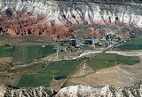
Cannonville, Utah
Encyclopedia
Cannonville is a town in Garfield County
, Utah
, United States
, along Utah Scenic Byway 12. In the 2000 census, the population was 148, a small increase over the 1990 figure of 131.
According to the United States Census Bureau
, the town has a total area of 1.2 square miles (3.2 km2), none of which is covered with water.
of 2000, there were 148 people, 50 households, and 41 families residing in the town. The population density
was 119.9 people per square mile (46.5/km2). There were 60 housing units at an average density of 48.6 per square mile (18.8/km2). The racial makeup of the town was 95.27% White, 0.68% Pacific Islander, 3.38% from other races
, and 0.68% from two or more races. Hispanic or Latino of any race were 4.05% of the population.
There were 50 households out of which 42.0% had children under the age of 18 living with them, 66.0% were married couples
living together, 14.0% had a female householder with no husband present, and 18.0% were non-families. 18.0% of all households were made up of individuals and 16.0% had someone living alone who was 65 years of age or older. The average household size was 2.96 and the average family size was 3.34.
In the town the population was spread out with 33.8% under the age of 18, 6.8% from 18 to 24, 19.6% from 25 to 44, 20.3% from 45 to 64, and 19.6% who were 65 years of age or older. The median age was 38 years. For every 100 females there were 117.6 males. For every 100 females age 18 and over, there were 96.0 males.
The median income for a household in the town was $28,750, and the median income for a family was $32,250. Males had a median income of $23,750 versus $12,083 for females. The per capita income
for the town was $11,481. None of the families and 3.7% of the population were living below the poverty line, including no under eighteens and 10.9% of those over 64.
Garfield County, Utah
Garfield County is a county located in the U.S. state of Utah. As of 2000 the population was 4,735. It was named for James A. Garfield, President of the United States in 1881. Its county seat and largest city is Panguitch.-Geography:...
, Utah
Utah
Utah is a state in the Western United States. It was the 45th state to join the Union, on January 4, 1896. Approximately 80% of Utah's 2,763,885 people live along the Wasatch Front, centering on Salt Lake City. This leaves vast expanses of the state nearly uninhabited, making the population the...
, United States
United States
The United States of America is a federal constitutional republic comprising fifty states and a federal district...
, along Utah Scenic Byway 12. In the 2000 census, the population was 148, a small increase over the 1990 figure of 131.
Geography
Cannonville is located at 37.566542°N 112.051533°W (37.566542, -112.051533).According to the United States Census Bureau
United States Census Bureau
The United States Census Bureau is the government agency that is responsible for the United States Census. It also gathers other national demographic and economic data...
, the town has a total area of 1.2 square miles (3.2 km2), none of which is covered with water.
Demographics
As of the censusCensus
A census is the procedure of systematically acquiring and recording information about the members of a given population. It is a regularly occurring and official count of a particular population. The term is used mostly in connection with national population and housing censuses; other common...
of 2000, there were 148 people, 50 households, and 41 families residing in the town. The population density
Population density
Population density is a measurement of population per unit area or unit volume. It is frequently applied to living organisms, and particularly to humans...
was 119.9 people per square mile (46.5/km2). There were 60 housing units at an average density of 48.6 per square mile (18.8/km2). The racial makeup of the town was 95.27% White, 0.68% Pacific Islander, 3.38% from other races
Race (United States Census)
Race and ethnicity in the United States Census, as defined by the Federal Office of Management and Budget and the United States Census Bureau, are self-identification data items in which residents choose the race or races with which they most closely identify, and indicate whether or not they are...
, and 0.68% from two or more races. Hispanic or Latino of any race were 4.05% of the population.
There were 50 households out of which 42.0% had children under the age of 18 living with them, 66.0% were married couples
Marriage
Marriage is a social union or legal contract between people that creates kinship. It is an institution in which interpersonal relationships, usually intimate and sexual, are acknowledged in a variety of ways, depending on the culture or subculture in which it is found...
living together, 14.0% had a female householder with no husband present, and 18.0% were non-families. 18.0% of all households were made up of individuals and 16.0% had someone living alone who was 65 years of age or older. The average household size was 2.96 and the average family size was 3.34.
In the town the population was spread out with 33.8% under the age of 18, 6.8% from 18 to 24, 19.6% from 25 to 44, 20.3% from 45 to 64, and 19.6% who were 65 years of age or older. The median age was 38 years. For every 100 females there were 117.6 males. For every 100 females age 18 and over, there were 96.0 males.
The median income for a household in the town was $28,750, and the median income for a family was $32,250. Males had a median income of $23,750 versus $12,083 for females. The per capita income
Per capita income
Per capita income or income per person is a measure of mean income within an economic aggregate, such as a country or city. It is calculated by taking a measure of all sources of income in the aggregate and dividing it by the total population...
for the town was $11,481. None of the families and 3.7% of the population were living below the poverty line, including no under eighteens and 10.9% of those over 64.