
.gif)
Boulder Mountain (Utah)
Encyclopedia
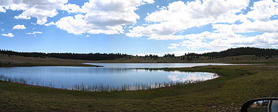
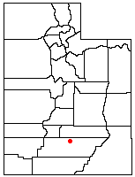
Boulder Mountain in Utah
, USA
makes up half of the Aquarius Plateau
of South Central Utah in Wayne
and Garfield
counties. The mountain rises to the west of Capitol Reef National Park
and consists of steep slopes and cliffs with over 50,000 acres (200 km²) of rolling forest and meadowlands on the top. It is the highest timbered plateau in North America and is part of the Dixie National Forest
.
Utah Scenic Byway 12 traverses the eastern side of the mountain from Torrey
through Boulder
and on to Escalante
. A series of unpaved backcountry roads and jeep trails provide access to the top during the brief snow free time, which is usually only a few months from July to September.
The Boulder Mountain cinquefoil
(Potentilla angelliae) is a rare species of plant that is endemic to Boulder Mountain.
Utah
Utah is a state in the Western United States. It was the 45th state to join the Union, on January 4, 1896. Approximately 80% of Utah's 2,763,885 people live along the Wasatch Front, centering on Salt Lake City. This leaves vast expanses of the state nearly uninhabited, making the population the...
, USA
United States
The United States of America is a federal constitutional republic comprising fifty states and a federal district...
makes up half of the Aquarius Plateau
Aquarius Plateau
The Aquarius Plateau is a physiographic region within Garfield and Wayne counties in south-central Utah. The plateau, an uplift on the much larger Colorado Plateau, is the highest in North America...
of South Central Utah in Wayne
Wayne County, Utah
Wayne County is a county located in the U.S. state of Utah. It was formed from Piute County in 1892. The county gets its name from a man who served as delegate to the constitutional convention, in honor of his son who was dragged to death by a horse. As of 2000 the population was 2,509, and by...
and Garfield
Garfield County, Utah
Garfield County is a county located in the U.S. state of Utah. As of 2000 the population was 4,735. It was named for James A. Garfield, President of the United States in 1881. Its county seat and largest city is Panguitch.-Geography:...
counties. The mountain rises to the west of Capitol Reef National Park
Capitol Reef National Park
Capitol Reef National Park is a United States National Park, in south-central Utah. It is 100 miles long but fairly narrow. The park, established in 1971, preserves 378 mi² and is open all year, although May through September are the most popular months.Called "Wayne Wonderland" in the 1920s...
and consists of steep slopes and cliffs with over 50,000 acres (200 km²) of rolling forest and meadowlands on the top. It is the highest timbered plateau in North America and is part of the Dixie National Forest
Dixie National Forest
Dixie National Forest is a United States National Forest in Utah with headquarters in Cedar City. It occupies almost two million acres and stretches for about 170 miles across southern Utah. The largest national forest in Utah, it straddles the divide between the Great Basin and the Colorado River...
.
Utah Scenic Byway 12 traverses the eastern side of the mountain from Torrey
Torrey, Utah
Torrey is a town located on State Route 24 in Wayne County, Utah, eight miles from Capitol Reef National Park. As of the 2000 census, the town had a total population of 171....
through Boulder
Boulder, Utah
Boulder is a town in Garfield County, Utah, United States, 27 miles northeast of Escalante on Utah Scenic Byway 12 at its intersection with the Burr Trail...
and on to Escalante
Escalante, Utah
Escalante is a city in Garfield County, Utah, United States, along Utah Scenic Byway 12. As of the 2000 census, the city population was 818.The town was named after Silvestre Vélez de Escalante, a Franciscan missionary and the first European explorer in the region...
. A series of unpaved backcountry roads and jeep trails provide access to the top during the brief snow free time, which is usually only a few months from July to September.
The Boulder Mountain cinquefoil
Potentilla angelliae
Potentilla angelliae is a rare species of flowering plant in the rose family known by the common names Angell cinquefoil and Boulder Mountain cinquefoil. It is endemic to Utah in the United States, where it is known only from Boulder Mountain on the Aquarius Plateau.This plant was first described...
(Potentilla angelliae) is a rare species of plant that is endemic to Boulder Mountain.