

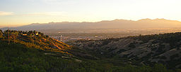
Salt Lake Valley
Encyclopedia
Salt Lake County, Utah
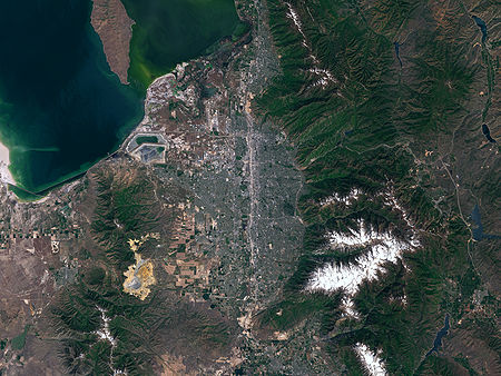
Salt Lake County is a county located in the U.S. state of Utah. It had a population of 1,029,655 at the 2010 census. Its county seat and largest city is Salt Lake City, the state capital. It occupies Salt Lake Valley, as well as parts of the surrounding mountains, the Oquirrh Mountains to the west...
in the north-central portion of the U.S. state
U.S. state
A U.S. state is any one of the 50 federated states of the United States of America that share sovereignty with the federal government. Because of this shared sovereignty, an American is a citizen both of the federal entity and of his or her state of domicile. Four states use the official title of...
of Utah
Utah
Utah is a state in the Western United States. It was the 45th state to join the Union, on January 4, 1896. Approximately 80% of Utah's 2,763,885 people live along the Wasatch Front, centering on Salt Lake City. This leaves vast expanses of the state nearly uninhabited, making the population the...
. It contains Salt Lake City
Salt Lake City, Utah
Salt Lake City is the capital and the most populous city of the U.S. state of Utah. The name of the city is often shortened to Salt Lake or SLC. With a population of 186,440 as of the 2010 Census, the city lies in the Salt Lake City metropolitan area, which has a total population of 1,124,197...
and many of its suburbs, notably West Valley City
West Valley City, Utah
West Valley City is a city in Salt Lake County and a suburb of Salt Lake City in the U.S. state of Utah. The population was 129,480 at the 2010 census,...
, Murray
Murray, Utah
Murray is a city situated on the Wasatch Front in the core of Salt Lake Valley in the U.S. state of Utah. Named for territorial governor Eli Murray, it is the state's fourteenth largest city. According to the 2010 census, Murray has approximately 46,746 residents.Murray is close to Salt Lake City,...
, Sandy
Sandy, Utah
Sandy is a city in Salt Lake County, Utah, United States. It is a suburb of Salt Lake City. The population was 87,461 at the 2010 census, making it the sixth-largest city in Utah....
, and West Jordan
West Jordan, Utah
West Jordan is a city in Salt Lake County, Utah, United States. West Jordan is a rapidly growing suburb of Salt Lake City and has a mixed economy. According to the 2010 Census, the city had a population of 103,712, placing it as the fourth most populated in the state. The city occupies the...
; its total population is 1,029,655 as of 2010. Brigham Young
Brigham Young
Brigham Young was an American leader in the Latter Day Saint movement and a settler of the Western United States. He was the President of The Church of Jesus Christ of Latter-day Saints from 1847 until his death in 1877, he founded Salt Lake City, and he served as the first governor of the Utah...
nicknamed it the place, when he and his fellow settlers moved into Utah after being driven out of several states.
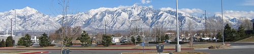
The valley is surrounded in every direction except the northwest by steep mountains that at some points rise 7100 feet (2,164.1 m) from the valley floor's base elevation. It lies nearly encircled by the Wasatch Mountains on the east, the Oquirrh Mountains
Oquirrh Mountains
The Oquirrh Mountains is a mountain range that run north-south for approximately 30 miles to form the west side of Utah's Salt Lake Valley, separating it from Tooele Valley. The range begins in northwest Utah County and stops at the south shore of the Great Salt Lake. The highest elevation is...
on the west, Traverse Ridge
Traverse Ridge
The Traverse Mountains, or sometimes Traverse Range, are an anomalous, geologically complex, east-trending range that separates Salt Lake Valley and Utah Valley in the U.S. State of Utah. The Traverse Mountains mark the boundary between the Salt Lake and Provo segments of the Wasatch Fault, and...
to the south and the Great Salt Lake
Great Salt Lake
The Great Salt Lake, located in the northern part of the U.S. state of Utah, is the largest salt water lake in the western hemisphere, the fourth-largest terminal lake in the world. In an average year the lake covers an area of around , but the lake's size fluctuates substantially due to its...
on the northwest, with the peaks of Antelope Island
Antelope Island
Antelope Island, with an area of , is the largest island of 10 islands located within the Great Salt Lake, Utah, United States. The island lies in the southeastern portion of the lake, near Salt Lake City and Davis County, and becomes a peninsula when the lake is at extremely low levels. Antelope...
visible.
Every entrance into the valley is extremely narrow and often congested. They include the Point of the Mountain to the south via the Jordan Narrows, a gap in the Traverse Mountains, narrow entrances between the Great Salt Lake and Oquirrh Mountains to the northwest and the Great Salt Lake and the Wasatch Mountains to the north, and several canyons to the east including Parley's Canyon
Parley's Canyon
Parley's Canyon is a canyon located in the U.S. state of Utah. The canyon provides the route of Interstate 80 up the western slope of the Wasatch Mountains and is a relatively wide, straight canyon. The lower part of the canyon, however, is relatively twisty and had to be dynamited to make way for...
and Emigration Canyon
Emigration Canyon
Emigration Canyon is a CDP, township and canyon in Salt Lake County, Utah, United States, located east of Salt Lake City in the Wasatch Range. Beginning at the southern end of the University of Utah, the canyon itself heads east and northeast between Salt Lake City and Morgan County. The boundaries...
.
The Jordan River
Jordan River (Utah)
The Jordan River in the U.S. state of Utah is a river about long. Regulated by pumps at its headwaters at Utah Lake, it flows northward through the Salt Lake Valley and empties into the Great Salt Lake. Four of Utah's five largest cities—Salt Lake City, West Valley City, West Jordan and...
runs north through the valley between Utah Lake
Utah Lake
Utah Lake is a freshwater lake in the U.S. state of Utah. On the western side of Utah Valley, the lake is overlooked by Mount Timpanogos and Mount Nebo. The lake's only river outlet, the Jordan River, is a tributary of the Great Salt Lake and is highly regulated with pumps. Evaporation accounts...
and the Great Salt Lake
Great Salt Lake
The Great Salt Lake, located in the northern part of the U.S. state of Utah, is the largest salt water lake in the western hemisphere, the fourth-largest terminal lake in the world. In an average year the lake covers an area of around , but the lake's size fluctuates substantially due to its...
bisecting the valley, and along with numerous mountain streams and reservoirs, provides irrigation water to the rapidly-growing valley. The only areas that have not been urbanized are near the Great Salt Lake (prevented by frequent flooding) and in the far west and mid-southwest parts of the valley, although even those areas are beginning to experience the effects of the Salt Lake City urban area's rapid expansion. Some experts are claiming that the valley will be urbanized rim-to-rim within the next 50 years.
A company known as Kennecott Land
Kennecott Land
Kennecott Land, a subsidiary of Rio Tinto Group, is an American land development company formed in 2001 and based in South Jordan, Utah. Kennecott Land owns 93,000 acres of undeveloped land in Salt Lake and Tooele counties in Utah, 75,000 acres of which are located in Salt Lake County...
, which owns the eastern foothills of the Oquirrhs in the western part of the valley, recently drafted a plan that would develop the rest of the entire valley within 75 years, adding at least 500,000 residents. The first development, known as the Daybreak Community
Daybreak Community
Daybreak is a master-planned community over 4,000 acres in size being built by land development company Kennecott Land in South Jordan, Utah. Home construction began in 2004 and the community is expected to continue building for the next 18 to 20 years...
, has already begun construction. It will focus on transit-oriented development
Transit-oriented development
A transit-oriented development is a mixed-use residential or commercial area designed to maximize access to public transport, and often incorporates features to encourage transit ridership...
and will also feature a ski resort in the Oquirrh Mountains
Oquirrh Mountains
The Oquirrh Mountains is a mountain range that run north-south for approximately 30 miles to form the west side of Utah's Salt Lake Valley, separating it from Tooele Valley. The range begins in northwest Utah County and stops at the south shore of the Great Salt Lake. The highest elevation is...
and a university campus.
Interstate 15 runs north to south through the middle-eastern portion of the valley and Interstate 80 runs east to west in the northern quarter of the valley from Parley's Canyon
Parley's Canyon
Parley's Canyon is a canyon located in the U.S. state of Utah. The canyon provides the route of Interstate 80 up the western slope of the Wasatch Mountains and is a relatively wide, straight canyon. The lower part of the canyon, however, is relatively twisty and had to be dynamited to make way for...
into Tooele County
Tooele County, Utah
Tooele County is a county located in the U.S. state of Utah. As of 2000, the population was 40,735 and by 2005 was estimated at 51,311. Its county seat and largest city is Tooele....
to the west (where it cuts across a portion of the Great Salt Lake). The Interstate 215
Interstate 215 (Utah)
Interstate 215 , also known locally as the belt route or two-fifteen, is an auxiliary interstate in the U.S. state of Utah that forms a 270-degree loop around Salt Lake City and many of its suburbs...
belt route, State Route 154 (Bangerter Highway), and State Route 201 are also major transportation routes. The Utah Transit Authority
Utah Transit Authority
The Utah Transit Authority operates a public transportation system throughout the Wasatch Front of Utah, United States. It operates fixed route buses, express buses, ski buses, three light rail lines , and a commuter rail line from Salt Lake City to Pleasant View, north of Ogden. UTA is based in...
operates an extensive bus system across the Wasatch Front
Wasatch Front
The Wasatch Front is a metropolitan region in the north-central part of the U.S. state of Utah. It consists of a chain of cities and towns stretched along the Wasatch Range from approximately Santaquin in the south to Brigham City in the north...
, including the Salt Lake Valley, in addition to three light rail
Light rail
Light rail or light rail transit is a form of urban rail public transportation that generally has a lower capacity and lower speed than heavy rail and metro systems, but higher capacity and higher speed than traditional street-running tram systems...
lines (known as TRAX
UTA TRAX
TRAX is a three-line light rail system in Utah's Salt Lake Valley, serving Salt Lake City and several of its suburbs throughout Salt Lake County. The system is operated by the Utah Transit Authority ....
) in the valley. A commuter rail line known as FrontRunner
FrontRunner
FrontRunner is a commuter rail system operated by the Utah Transit Authority , serving the northern portion of the Wasatch Front from Salt Lake Central Station to Ogden Union Station. The system opened 26 April 2008...
runs north to Pleasant View
Pleasant View, Utah
Pleasant View is a city in Weber County, Utah, United States. The population was 5,632 at the 2000 census. It is part of the Ogden–Clearfield, Utah Metropolitan Statistical Area...
in Weber County
Weber County, Utah
Weber County is a county located in the U.S. state of Utah, occupying a stretch of the Wasatch Front, part of the eastern shores of Great Salt Lake, and much of the rugged Wasatch Mountains. As of the 2000 census, the population was 196,533, an increase of 24.1% over its population in 1990. By...
.
See also
- Mormon TrailMormon TrailThe Mormon Trail or Mormon Pioneer Trail is the 1,300 mile route that members of The Church of Jesus Christ of Latter-day Saints traveled from 1846 to 1868...