
Salt Lake County, Utah
Encyclopedia
Salt Lake County is a county located in the U.S. state
of Utah
. It had a population of 1,029,655 at the 2010 census
. Its county seat
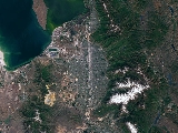
and largest city is Salt Lake City, the state capital. It occupies Salt Lake Valley
, as well as parts of the surrounding mountains, the Oquirrh Mountains
to the west and the Wasatch Range
to the east. In addition, the Great Salt Lake
is partially within the northwestern section of the county. The county is famous for its ski resort
s, which led to Salt Lake City hosting the 2002 Winter Olympics
.
Salt Lake County is part of the Salt Lake City Metropolitan Statistical Area
as well as the Salt Lake City–Ogden
–Clearfield
Combined Statistical Area.
, the county has a total area of 808 square miles (2,092.7 km²), of which 737 square miles (1,908.8 km²) is land and 70 square miles (181.3 km²) (8.72%) is water.
Perhaps the most dominating physical feature in Salt Lake County are the Wasatch Mountains in the eastern portion of the county, famous for both summer and winter activities. The snow in the region is often coined the "Greatest Snow on Earth" for its soft, powdery texture, and led to Salt Lake City winning the bid for the 2002 Winter Olympics
. In Salt Lake County there are four ski resorts; Snowbird and Alta
in Little Cottonwood Canyon
and Solitude and Brighton
in Big Cottonwood Canyon
. Hiking and camping are especially popular summer activities. Marking the western portion of the county are the Oquirrh Mountains
. These two mountain ranges together, along with the much smaller Traverse Mountains to the south of the valley, delimit Salt Lake Valley
, which is also flanked on the northwest by the Great Salt Lake
, and the north by the Salt Lake Anticline.
 All of the entrances to the valley are narrow. These include Parley's Canyon
leading into Summit County
to the northeast, Emigration Canyon
leading into Morgan County
, also to the northeast, the space between the Salt Lake Anticline and the Great Salt Lake leading into Davis County
to the north, the "Point of the Mountain" leading to Utah County
to the south, and a space between the Oqiurrh Mountains and the Great Salt Lake leading to Tooele County
to the northwest. On the north and east benches, the houses sometimes climb as far as halfway up the mountain, and new communities are also being constructed on the steeper southern and western slopes. Rapid residential construction continues in the west-central, southwest, and southern portions of the valley. In the far west, southwest, and northwest, rural areas still exist, but rapid growth threatens what remains of the natural environment in the valley.
. This leaves much of the west side in the rain shadow of the Oquirrh Mountains
. Up to 20 inches (500 mm) is received on the benches. Most of this precipitation is received in spring. The summer is dry, with the majority of precipitation arriving from the monsoon
that rises from the south. Short, localized, and often dry thunderstorm
s are usually associated with the monsoon. However, some of them can be very intense. These storms can also cause flash flood
s and wildfire
s (due to dry lightning and powerful winds). Precipitation is heaviest in late fall/early winter and in spring, while early summer is the driest season.
The valley receives 55 inches (140 cm) or more of snow in a year, with up to 100 inches (250 cm) received on the benches. Most of the snow falls from mid-November through March. The mountains receive up to 500 inches (1,270 cm) of light, dry snow and up to 55 inches (1400 mm) of precipitation annually. The dry snow is often considered good for skiing, contributing to the four ski resorts in the county. Snow usually falls from October through May. The heavy snow totals across the county can be attributed to the lake-effect, where precipitation is intensified by the warm waters of the Great Salt Lake, which never entirely freezes due to the lake's high salinity. The lake-effect can affect any area of the county. The dry snow is attributed to the low humidity of the region.
During winter, temperature inversions are a common problem. The inversion will trap pollutants, moisture, and cold temperatures in the valley while the surrounding mountains enjoy warm temperatures and brilliant sunshine. This can cause some melting snow in the mountains and unhealthy air quality and low visibility in the valley. This weather event lasts from a few days to up to a month in extreme cases, and is caused by a very strong high pressure positioned over the Great Basin
.
of 2010, there were 1,029,655 people, 343,218 households, and 291,686 families residing in the county. The population density
was 1,274 people per square mile (791/km²). There were 364,031 housing units at an average density of 450 per square mile (279/km²). The racial makeup of the county was 81.2% White
, 1.59% Black
or African American
, 0.89% Native American
, 3.3% Asian
, 1.53% Pacific Islander
, 8.35% from other races
, and 3.14% from two or more races. 17.09% of the population were Hispanic
or Latino
of any race.
By 2007 Non-Hispanic whites were 76.5% of Salt Lake County's population and Latinos were 15.7% of the population. African-Americans were 1.7% of the population. Asians were 3% of the population, while Pacific Islanders were 1.3%. Native Americans were still 1% of the population. The Census' 2005 American Community Survey indicated that 11.4% of Salt Lake County's population living in households (as opposed to group arrangements such as college dormitories) spoke Spanish at home.
In 2010 there were 343,218 households out of which 40.10% had children under the age of 18 living with them, 57.80% were married couples
living together, 10.40% had a female householder with no husband present, and 27.50% were non-families. 20.80% of all households were made up of individuals and 6.20% had someone living alone who was 65 years of age or older. The average household size was 3.00 and the average family size was 3.53.
In the county, the population was spread out with 30.50% under the age of 18, 12.90% from 18 to 24, 30.60% from 25 to 44, 18.00% from 45 to 64, and 8.10% who were 65 years of age or older. The median age was 29 years. For every 100 females there were 101.70 males. For every 100 females age 18 and over, there were 99.70 males.
The median income for a household in the county was $48,373, and the median income for a family was $54,470. Males had a median income of $36,953 versus $26,105 for females. The per capita income
for the county was $20,190. About 5.70% of families and 8.00% of the population were below the poverty line, including 9.00% of those under age 18 and 5.50% of those age 65 or over.
By 2009 the county population had risen to 1,034,989, or 15.2% since 2000. This was a rise below the rate for the state overall; however, Utah
was the 2nd fastest growing state (after Wyoming
)in 2009 according to the U.S. Census Bureau.
after traveling through Emigration Canyon
. Brigham Young
, their leader, declared "This is the place" after seeing the valley, which was at the time arid, dry, and unpromising. However, they soon developed a flourishing, self-sufficient city, Great Salt Lake City
, through extensive irrigation
techniques. Thousands of Mormons from around the world followed in the next several decades. The county was officially formed on January 31, 1850, with just over 11,000 residents recorded.
Settlements were scattered across the valley and beyond, and the territorial capital was moved to Great Salt Lake City in 1857, when the name was subsequently shortened to Salt Lake City. In 1858, when the Utah Territory
was declared in rebellion after governor Brigham Young refused to step down for The Church of Jesus Christ of Latter-day Saints' polygamous practices, the government sent troops to install a new governor and keep watch over the place. However, the valley was abandoned and the troops set up Camp Floyd
to the south in Utah County
. In 1862, Fort Douglas was established on the eastern bench, near the current site of the University of Utah
, to make sure that the territory maintained its allegiance during the American Civil War
.
Patrick Edward Connor
, who was the leader of the garrison stationed at Fort Douglas, was openly anti-Mormon
and sent out parties to scout for mineral resources in the nearby mountains to encourage non-Mormons to settle there. During the late 19th century, mines were established in the mountains, most notably around Alta
. Exploiting the mineral wealth was difficult until the Utah Central Railroad arrived in 1870. The Bingham Canyon Mine
, which contains vast deposits of copper
and silver
, was the most notable of the mines that was established. The mine, located in the Oquirrh Mountains
in the southwest portion of the county, attracted thousands of settlers to the narrow canyon. At its peak, the city of Bingham Canyon
contained 20,000 residents all crowded along the steep walls of the canyon, and natural disasters were a frequent occurrence. By the early 20th century, most of the mines in the county had closed. However, the Bingham Canyon Mine kept on expanding, and today is among the largest open-pit mines
in the world.
. The trolley system was mostly dismantled by 1945 as car
s outpaced public transportation across the country. Throughout the late 19th and early 20th centuries, the east side of the valley began to be heavily-settled. In 1942, Camp Kearns, a massive military installation created for World War II
, was created in what is now Kearns
and Taylorsville
on the western side of the valley. After the camp was closed in 1946, the land was sold off and rapid settlement of the area began. Other major defensive installations were set up along the Wasatch Front
and in the Great Salt Lake Desert
during World War II, further encouraging growth and boosting the economy, as well as establishing Utah as a major military center. In the nation-wide suburb
boom of the late 1940s, 1950s, and early 1960s, such cities as South Salt Lake
, Murray
, Midvale
, and much of the east side of the valley grew rapidly.
The airport was upgraded to international status in the 1960s and became Salt Lake City International Airport
. Like all of the industrialized cities throughout the nation, Salt Lake City faced inner-city decay beginning especially in the 1960s, while the suburbs grew tremendously. Growth in such cities as Sandy
, West Jordan
, and what would become West Valley City
was phenomenal in the 1970s and 1980s. Huge residential tracts were created through the center of the valley, and within ten years, the entire area had been converted from farmland into sprawling bedroom communities to Salt Lake City. West Valley City was created from the merger of the three unincorporated cities of Granger, Hunter, and Chesterfield in 1980. However, not every area of the county saw growth. Not only was Salt Lake City facing urban decay, but the cities that provided residences for the miners in Bingham Canyon were torn down in the 1960s and 1970s. The city of Bingham Canyon
was completely torn down and swallowed up in the mine by 1972, and the dismantling of Lark
in 1980 completed the process. The only remaining mining town in the county is Copperton
, located southwest of West Jordan
, with approximately 800 residents.
Beginning especially in the 1990s, rapid growth shifted further south and west. Old farmland and pastureland was swallowed up by new residential development. The cities of West Jordan
, South Jordan
, Riverton
, Herriman
, and Draper
are some of the fastest growing cities in the state. During the 1990s, Salt Lake City began reversing the trend of inner-city decay, and its population grew for the first time in 40 years. Salt Lake City's selection as the host of the 2002 Winter Olympics spurred a construction boom in the city that continued well after the Olympics left, until a recession began in 2008. As the county's population has surpassed 1 million, one of the main issues in the county is urbanization
. Only a few small rural areas remain in the far west of the valley. Other issues facing the county today include pollution
and transportation.
According to data from the LDS Church and the State of Utah, Salt Lake County was 53% LDS (Mormon) in 2004, as reported in the Salt Lake Tribune. Extrapolating corresponding figures of 62% LDS in 1994 and 57% in 1999, along with the 2004 figure of 53%, renders an estimate that Salt Lake County is very likely less than 50% LDS today.
, defense industries in the region have also played a very important role in the economy due to its strategic central location in the Western United States
, as well as the largely uninhabited and desolate Great Salt Lake Desert
to the west.
Beginning in 1939, with the opening of Alta Ski Area
, skiing and other winter sports (as well as summer sports), have become a major force in the economy. In 1995, Salt Lake City won the bid to host the 2002 Winter Olympics
. The 2002 Olympics boosted tourism and the economy, and helped to dramatically improve transportation throughout the county. Transportation has been a major focus, as the county continues to rapidly grow in population. It was drastically improved beginning in the late 80s and through the 90s, and continues to this day. Beginning in the 1960s, a more service-oriented economy began to develop, and information technologies began to arrive in the 80s and 90s. Although this business has waned in recent years, information and computer companies, such as Overstock.com
, are still a thriving business here.
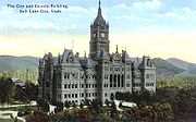 Salt Lake County is unique in that it has a partisan county mayor. The current county mayor is Peter Corroon
, a Democrat. Former county mayors include Nancy Workman
and Alan Dayton
(Workman's deputy mayor; Sworn in as acting mayor in September 2004 when Nancy Workman was placed on paid administrative leave).
. Members include three elected at-large
and six elected by district. Council members from districts serve four-year staggered terms in partisan elections while at-large members serve six years.
, especially in state and federal elections. In 2004, Republican President George W. Bush
won the county over Democrat
John Kerry
59% to 37%. In 2008, however, Democrat Barack Obama
won Salt Lake County by an extremely narrow margin, 48.17% to 48.09, over Republican John McCain
- a difference of 296 votes. It was the first time since 1964, when Lyndon B. Johnson
was the Democratic candidate, that Salt Lake County had voted for a Democrat.
and Murray
operate their own school districts (although a recent annexation by Murray leaves a part of the city within the Granite School District). The Granite School District
, the largest in the state, is a broad district that covers a swath from Kearns
and Taylorsville
through West Valley City, Utah
and eastward to South Salt Lake
and Millcreek Township
, among others. The Jordan School District
, with approximately 48,000 students, covers the southwest part of the county, including West Jordan
; the new Canyons School District includes Sandy
, and Draper
. On November 6, 2007, the east side residents of the Jordan School District in Sandy, Draper, Midvale
, Cottonwood Heights
, and nearby unincorporated areas, voted to split from the Jordan District. A similar vote to make West Jordan its own district, however, failed.
Two high schools have closed:
In addition, the Roman Catholic Diocese of Salt Lake City
operates 8 elementary schools, 1 middle school, 2 high schools, and 2 preschools in Salt Lake County. Judge Memorial Catholic High School
in Salt Lake City
is the largest Catholic high school in Utah. The Catholic Church also operates Juan Diego High School
in Draper
.
Salt Lake County also has several independent schools including:
|expressway]]. US-89 enters from Davis County
to the north and traverses the county arrow-straight until merging with I-15 in north Draper
. It is known as State Street along most of the route and is the primary surface road in the valley. I-15 and I-80 intersect just west of Downtown Salt Lake City
, merging for approximately 3 miles (4.8 km) north-to-south. I-80 continues west past the Salt Lake City International Airport
and east through Parley's Canyon
and into the Wasatch Range
. I-15 traverses the valley north-to-south, providing access to the entire urban corridor. The freeway is 10-12 lanes wide after a major expansion project from 1998 to 2001 undertaken in preparation for the 2002 Winter Olympics
. I-215
directly serves many of the suburbs of Salt Lake City in the western, central, and eastern portions of the valley in a 270° loop. SR-201, alternatively known as the "21st South Freeway", provides access to West Valley City
and the west side of the valley. Bangerter Highway (SR-154) is an expressway that traverses the entire western end of the valley from the airport, ending at I-15 in southern Draper. SR-68, or Redwood Road, is the only surface street that traverses the entire valley from north-to-south.
A light rail
system, known as TRAX
, is operated by the Utah Transit Authority
(UTA) and runs from the Salt Lake Central Station in downtown Salt Lake City south to Sandy, with another line east to the University of Utah
; the system currently has 28 stops. Extensions to the airport, West Valley City
, and South Jordan
are under construction and another to Draper
has been approved, with completion of all four expected by 2014. A commuter rail line, FrontRunner
, began operation in April 2008 between the Salt Lake Central Station in downtown Salt lake City and Pleasant View
. An extension south to Provo
is under construction and is expected to be complete by 2012. UTA also operates bus routes to nearly every location in the valley and routes to the ski resorts in winter. The Legacy Parkway
opened in 2008 to connect with I-215 at the north end of the valley, providing an alternative route into Davis County to alleviate congestion. The Mountain View Corridor
is a freeway planned to be constructed down the far west side of the valley. A historic streetcar is also being considered along 2100 South from the TRAX station to the historic business district in the Sugar House
neighborhood.
s (CDPs), but the boundaries set by the Census Bureau and the county do not always coincide.
Townships:
Community Councils:
People
U.S. state
A U.S. state is any one of the 50 federated states of the United States of America that share sovereignty with the federal government. Because of this shared sovereignty, an American is a citizen both of the federal entity and of his or her state of domicile. Four states use the official title of...
of Utah
Utah
Utah is a state in the Western United States. It was the 45th state to join the Union, on January 4, 1896. Approximately 80% of Utah's 2,763,885 people live along the Wasatch Front, centering on Salt Lake City. This leaves vast expanses of the state nearly uninhabited, making the population the...
. It had a population of 1,029,655 at the 2010 census
United States Census, 2010
The Twenty-third United States Census, known as Census 2010 or the 2010 Census, is the current national census of the United States. National Census Day was April 1, 2010 and is the reference date used in enumerating individuals...
. Its county seat
County seat
A county seat is an administrative center, or seat of government, for a county or civil parish. The term is primarily used in the United States....
and largest city is Salt Lake City, the state capital. It occupies Salt Lake Valley
Salt Lake Valley
Salt Lake Valley is a valley in Salt Lake County in the north-central portion of the U.S. state of Utah. It contains Salt Lake City and many of its suburbs, notably West Valley City, Murray, Sandy, and West Jordan; its total population is 1,029,655 as of 2010...
, as well as parts of the surrounding mountains, the Oquirrh Mountains
Oquirrh Mountains
The Oquirrh Mountains is a mountain range that run north-south for approximately 30 miles to form the west side of Utah's Salt Lake Valley, separating it from Tooele Valley. The range begins in northwest Utah County and stops at the south shore of the Great Salt Lake. The highest elevation is...
to the west and the Wasatch Range
Wasatch Range
The Wasatch Range is a mountain range that stretches approximately from the Utah-Idaho border, south through central Utah in the western United States. It is generally considered the western edge of the greater Rocky Mountains, and the eastern edge of the Great Basin region...
to the east. In addition, the Great Salt Lake
Great Salt Lake
The Great Salt Lake, located in the northern part of the U.S. state of Utah, is the largest salt water lake in the western hemisphere, the fourth-largest terminal lake in the world. In an average year the lake covers an area of around , but the lake's size fluctuates substantially due to its...
is partially within the northwestern section of the county. The county is famous for its ski resort
Ski resort
A ski resort is a resort developed for skiing and other winter sports. In Europe a ski resort is a town or village in a ski area - a mountainous area, where there are ski trails and supporting services such as hotels and other accommodation, restaurants, equipment rental and a ski lift system...
s, which led to Salt Lake City hosting the 2002 Winter Olympics
2002 Winter Olympics
The 2002 Winter Olympics, officially the XIX Olympic Winter Games, were a winter multi-sport event that was celebrated in February 2002 in and around Salt Lake City, Utah, United States. Approximately 2,400 athletes from 77 nations participated in 78 events in fifteen disciplines, held throughout...
.
Salt Lake County is part of the Salt Lake City Metropolitan Statistical Area
Salt Lake City metropolitan area
The Salt Lake City Metropolitan Statistical Area, as defined by the United States Census Bureau, is an area consisting of three counties in north central Utah, anchored by Salt Lake City. As of the 2000 census, the MSA had a population of 968,858. As of July 1, 2009 the U.S...
as well as the Salt Lake City–Ogden
Ogden, Utah
Ogden is a city in Weber County, Utah, United States. Ogden serves as the county seat of Weber County. The population was 82,825 according to the 2010 Census. The city served as a major railway hub through much of its history, and still handles a great deal of freight rail traffic which makes it a...
–Clearfield
Clearfield, Utah
Clearfield is a city in Davis County, Utah, United States. The population was 25,974 at the 2000 census. The city grew drastically during the 1940s, with the formation of Hill Air Force Base, and in the 1950s with the nation-wide increase in suburb and "bedroom" community populations and has been...
Combined Statistical Area.
Geography
According to the U.S. Census BureauUnited States Census Bureau
The United States Census Bureau is the government agency that is responsible for the United States Census. It also gathers other national demographic and economic data...
, the county has a total area of 808 square miles (2,092.7 km²), of which 737 square miles (1,908.8 km²) is land and 70 square miles (181.3 km²) (8.72%) is water.
Perhaps the most dominating physical feature in Salt Lake County are the Wasatch Mountains in the eastern portion of the county, famous for both summer and winter activities. The snow in the region is often coined the "Greatest Snow on Earth" for its soft, powdery texture, and led to Salt Lake City winning the bid for the 2002 Winter Olympics
2002 Winter Olympics
The 2002 Winter Olympics, officially the XIX Olympic Winter Games, were a winter multi-sport event that was celebrated in February 2002 in and around Salt Lake City, Utah, United States. Approximately 2,400 athletes from 77 nations participated in 78 events in fifteen disciplines, held throughout...
. In Salt Lake County there are four ski resorts; Snowbird and Alta
Alta Ski Area
Alta is a ski area located in the Wasatch Mountains, just east of Salt Lake City, Utah. With a skiable area of 2200 acres , beginning at a base elevation of 8530 ft and rising to 10,550 ft for a vertical gain of 2020 ft . Alta is one of the oldest ski resorts in the country,...
in Little Cottonwood Canyon
Little Cottonwood Canyon
Little Cottonwood Canyon lies within the Wasatch-Cache National Forest along the eastern side of the Salt Lake Valley, roughly 15 miles from Salt Lake City, Utah. The canyon is part of Granite, a CDP and “Community Council” designated by Salt Lake County. The canyon is a glacial trough , carved by...
and Solitude and Brighton
Brighton Ski Resort
Brighton Ski Resort is a ski area located in Big Cottonwood Canyon, from downtown Salt Lake City, Utah. Brighton Ski Resort was the first ski resort in Utah, and one of the first in the United States. Brighton was started in 1936 when members of the Alpine Ski Club built a rope tow from wire and...
in Big Cottonwood Canyon
Big Cottonwood Canyon
Big Cottonwood Canyon is a canyon in the Wasatch Range southeast of Salt Lake City in the U.S. state of Utah. The -long canyon provides hiking, biking, picnicking, rock-climbing, camping and fishing in the summer. During winter, its two ski resorts, Brighton and Solitude, are popular among skiers...
. Hiking and camping are especially popular summer activities. Marking the western portion of the county are the Oquirrh Mountains
Oquirrh Mountains
The Oquirrh Mountains is a mountain range that run north-south for approximately 30 miles to form the west side of Utah's Salt Lake Valley, separating it from Tooele Valley. The range begins in northwest Utah County and stops at the south shore of the Great Salt Lake. The highest elevation is...
. These two mountain ranges together, along with the much smaller Traverse Mountains to the south of the valley, delimit Salt Lake Valley
Salt Lake Valley
Salt Lake Valley is a valley in Salt Lake County in the north-central portion of the U.S. state of Utah. It contains Salt Lake City and many of its suburbs, notably West Valley City, Murray, Sandy, and West Jordan; its total population is 1,029,655 as of 2010...
, which is also flanked on the northwest by the Great Salt Lake
Great Salt Lake
The Great Salt Lake, located in the northern part of the U.S. state of Utah, is the largest salt water lake in the western hemisphere, the fourth-largest terminal lake in the world. In an average year the lake covers an area of around , but the lake's size fluctuates substantially due to its...
, and the north by the Salt Lake Anticline.
Parley's Canyon
Parley's Canyon is a canyon located in the U.S. state of Utah. The canyon provides the route of Interstate 80 up the western slope of the Wasatch Mountains and is a relatively wide, straight canyon. The lower part of the canyon, however, is relatively twisty and had to be dynamited to make way for...
leading into Summit County
Summit County, Utah
Summit County is a county located in the U.S. state of Utah, occupying a rugged and mountainous area. In 2010 its population was 36,324. It is part of the Salt Lake City Metropolitan Statistical Area as well as the Salt Lake City–Ogden–Clearfield Combined Statistical Area. The county is...
to the northeast, Emigration Canyon
Emigration Canyon
Emigration Canyon is a CDP, township and canyon in Salt Lake County, Utah, United States, located east of Salt Lake City in the Wasatch Range. Beginning at the southern end of the University of Utah, the canyon itself heads east and northeast between Salt Lake City and Morgan County. The boundaries...
leading into Morgan County
Morgan County, Utah
Morgan County is a county located in the U.S. state of Utah. As of 2010 the population was 9,469. It was named for Jedediah Morgan Grant, father of Heber J. Grant, who served as president of the Church of Jesus Christ of Latter-day Saints...
, also to the northeast, the space between the Salt Lake Anticline and the Great Salt Lake leading into Davis County
Davis County, Utah
Davis County is a county located in the U.S. state of Utah. As of 2010 the population was 306,479, a 28.2% increase over the 2000 figure of 238,994. It was named for Daniel C. Davis, captain in the Mormon Battalion. The county is part of the Ogden–Clearfield Metropolitan Statistical Area as...
to the north, the "Point of the Mountain" leading to Utah County
Utah County, Utah
Utah County is a county located in the U.S. state of Utah. As of 2000, the population was 368,536 and by 2008 was estimated at 530,837. It was named for the Spanish name for the Ute Indians. The county seat and largest city is Provo...
to the south, and a space between the Oqiurrh Mountains and the Great Salt Lake leading to Tooele County
Tooele County, Utah
Tooele County is a county located in the U.S. state of Utah. As of 2000, the population was 40,735 and by 2005 was estimated at 51,311. Its county seat and largest city is Tooele....
to the northwest. On the north and east benches, the houses sometimes climb as far as halfway up the mountain, and new communities are also being constructed on the steeper southern and western slopes. Rapid residential construction continues in the west-central, southwest, and southern portions of the valley. In the far west, southwest, and northwest, rural areas still exist, but rapid growth threatens what remains of the natural environment in the valley.
Adjacent counties
- Tooele CountyTooele County, UtahTooele County is a county located in the U.S. state of Utah. As of 2000, the population was 40,735 and by 2005 was estimated at 51,311. Its county seat and largest city is Tooele....
- west - Utah CountyUtah County, UtahUtah County is a county located in the U.S. state of Utah. As of 2000, the population was 368,536 and by 2008 was estimated at 530,837. It was named for the Spanish name for the Ute Indians. The county seat and largest city is Provo...
- south - Wasatch CountyWasatch County, UtahWasatch County is a county located in the U.S. state of Utah. It was named for a Ute Indian word meaning mountain pass or low place in the high mountains. Its county seat and largest city is Heber City.The county is governed by a county council with an appointed county manager.Wasatch County is...
- southeast - Summit CountySummit County, UtahSummit County is a county located in the U.S. state of Utah, occupying a rugged and mountainous area. In 2010 its population was 36,324. It is part of the Salt Lake City Metropolitan Statistical Area as well as the Salt Lake City–Ogden–Clearfield Combined Statistical Area. The county is...
- east - Morgan CountyMorgan County, UtahMorgan County is a county located in the U.S. state of Utah. As of 2010 the population was 9,469. It was named for Jedediah Morgan Grant, father of Heber J. Grant, who served as president of the Church of Jesus Christ of Latter-day Saints...
- northeast - Davis CountyDavis County, UtahDavis County is a county located in the U.S. state of Utah. As of 2010 the population was 306,479, a 28.2% increase over the 2000 figure of 238,994. It was named for Daniel C. Davis, captain in the Mormon Battalion. The county is part of the Ogden–Clearfield Metropolitan Statistical Area as...
- north
Climate
The Salt Lake Valley receives, on average, approximately 15 inches (380 mm) of precipitation annually, usually with more on the east side and less on the west side, as most storms come from the Pacific OceanPacific Ocean
The Pacific Ocean is the largest of the Earth's oceanic divisions. It extends from the Arctic in the north to the Southern Ocean in the south, bounded by Asia and Australia in the west, and the Americas in the east.At 165.2 million square kilometres in area, this largest division of the World...
. This leaves much of the west side in the rain shadow of the Oquirrh Mountains
Oquirrh Mountains
The Oquirrh Mountains is a mountain range that run north-south for approximately 30 miles to form the west side of Utah's Salt Lake Valley, separating it from Tooele Valley. The range begins in northwest Utah County and stops at the south shore of the Great Salt Lake. The highest elevation is...
. Up to 20 inches (500 mm) is received on the benches. Most of this precipitation is received in spring. The summer is dry, with the majority of precipitation arriving from the monsoon
Monsoon
Monsoon is traditionally defined as a seasonal reversing wind accompanied by corresponding changes in precipitation, but is now used to describe seasonal changes in atmospheric circulation and precipitation associated with the asymmetric heating of land and sea...
that rises from the south. Short, localized, and often dry thunderstorm
Thunderstorm
A thunderstorm, also known as an electrical storm, a lightning storm, thundershower or simply a storm is a form of weather characterized by the presence of lightning and its acoustic effect on the Earth's atmosphere known as thunder. The meteorologically assigned cloud type associated with the...
s are usually associated with the monsoon. However, some of them can be very intense. These storms can also cause flash flood
Flash flood
A flash flood is a rapid flooding of geomorphic low-lying areas—washes, rivers, dry lakes and basins. It may be caused by heavy rain associated with a storm, hurricane, or tropical storm or meltwater from ice or snow flowing over ice sheets or snowfields...
s and wildfire
Wildfire
A wildfire is any uncontrolled fire in combustible vegetation that occurs in the countryside or a wilderness area. Other names such as brush fire, bushfire, forest fire, desert fire, grass fire, hill fire, squirrel fire, vegetation fire, veldfire, and wilkjjofire may be used to describe the same...
s (due to dry lightning and powerful winds). Precipitation is heaviest in late fall/early winter and in spring, while early summer is the driest season.
The valley receives 55 inches (140 cm) or more of snow in a year, with up to 100 inches (250 cm) received on the benches. Most of the snow falls from mid-November through March. The mountains receive up to 500 inches (1,270 cm) of light, dry snow and up to 55 inches (1400 mm) of precipitation annually. The dry snow is often considered good for skiing, contributing to the four ski resorts in the county. Snow usually falls from October through May. The heavy snow totals across the county can be attributed to the lake-effect, where precipitation is intensified by the warm waters of the Great Salt Lake, which never entirely freezes due to the lake's high salinity. The lake-effect can affect any area of the county. The dry snow is attributed to the low humidity of the region.
During winter, temperature inversions are a common problem. The inversion will trap pollutants, moisture, and cold temperatures in the valley while the surrounding mountains enjoy warm temperatures and brilliant sunshine. This can cause some melting snow in the mountains and unhealthy air quality and low visibility in the valley. This weather event lasts from a few days to up to a month in extreme cases, and is caused by a very strong high pressure positioned over the Great Basin
Great Basin
The Great Basin is the largest area of contiguous endorheic watersheds in North America and is noted for its arid conditions and Basin and Range topography that varies from the North American low point at Badwater Basin to the highest point of the contiguous United States, less than away at the...
.
Demographics
As of the censusCensus
A census is the procedure of systematically acquiring and recording information about the members of a given population. It is a regularly occurring and official count of a particular population. The term is used mostly in connection with national population and housing censuses; other common...
of 2010, there were 1,029,655 people, 343,218 households, and 291,686 families residing in the county. The population density
Population density
Population density is a measurement of population per unit area or unit volume. It is frequently applied to living organisms, and particularly to humans...
was 1,274 people per square mile (791/km²). There were 364,031 housing units at an average density of 450 per square mile (279/km²). The racial makeup of the county was 81.2% White
Race (United States Census)
Race and ethnicity in the United States Census, as defined by the Federal Office of Management and Budget and the United States Census Bureau, are self-identification data items in which residents choose the race or races with which they most closely identify, and indicate whether or not they are...
, 1.59% Black
Race (United States Census)
Race and ethnicity in the United States Census, as defined by the Federal Office of Management and Budget and the United States Census Bureau, are self-identification data items in which residents choose the race or races with which they most closely identify, and indicate whether or not they are...
or African American
Race (United States Census)
Race and ethnicity in the United States Census, as defined by the Federal Office of Management and Budget and the United States Census Bureau, are self-identification data items in which residents choose the race or races with which they most closely identify, and indicate whether or not they are...
, 0.89% Native American
Race (United States Census)
Race and ethnicity in the United States Census, as defined by the Federal Office of Management and Budget and the United States Census Bureau, are self-identification data items in which residents choose the race or races with which they most closely identify, and indicate whether or not they are...
, 3.3% Asian
Race (United States Census)
Race and ethnicity in the United States Census, as defined by the Federal Office of Management and Budget and the United States Census Bureau, are self-identification data items in which residents choose the race or races with which they most closely identify, and indicate whether or not they are...
, 1.53% Pacific Islander
Race (United States Census)
Race and ethnicity in the United States Census, as defined by the Federal Office of Management and Budget and the United States Census Bureau, are self-identification data items in which residents choose the race or races with which they most closely identify, and indicate whether or not they are...
, 8.35% from other races
Race (United States Census)
Race and ethnicity in the United States Census, as defined by the Federal Office of Management and Budget and the United States Census Bureau, are self-identification data items in which residents choose the race or races with which they most closely identify, and indicate whether or not they are...
, and 3.14% from two or more races. 17.09% of the population were Hispanic
Race (United States Census)
Race and ethnicity in the United States Census, as defined by the Federal Office of Management and Budget and the United States Census Bureau, are self-identification data items in which residents choose the race or races with which they most closely identify, and indicate whether or not they are...
or Latino
Race (United States Census)
Race and ethnicity in the United States Census, as defined by the Federal Office of Management and Budget and the United States Census Bureau, are self-identification data items in which residents choose the race or races with which they most closely identify, and indicate whether or not they are...
of any race.
By 2007 Non-Hispanic whites were 76.5% of Salt Lake County's population and Latinos were 15.7% of the population. African-Americans were 1.7% of the population. Asians were 3% of the population, while Pacific Islanders were 1.3%. Native Americans were still 1% of the population. The Census' 2005 American Community Survey indicated that 11.4% of Salt Lake County's population living in households (as opposed to group arrangements such as college dormitories) spoke Spanish at home.
In 2010 there were 343,218 households out of which 40.10% had children under the age of 18 living with them, 57.80% were married couples
Marriage
Marriage is a social union or legal contract between people that creates kinship. It is an institution in which interpersonal relationships, usually intimate and sexual, are acknowledged in a variety of ways, depending on the culture or subculture in which it is found...
living together, 10.40% had a female householder with no husband present, and 27.50% were non-families. 20.80% of all households were made up of individuals and 6.20% had someone living alone who was 65 years of age or older. The average household size was 3.00 and the average family size was 3.53.
In the county, the population was spread out with 30.50% under the age of 18, 12.90% from 18 to 24, 30.60% from 25 to 44, 18.00% from 45 to 64, and 8.10% who were 65 years of age or older. The median age was 29 years. For every 100 females there were 101.70 males. For every 100 females age 18 and over, there were 99.70 males.
The median income for a household in the county was $48,373, and the median income for a family was $54,470. Males had a median income of $36,953 versus $26,105 for females. The per capita income
Per capita income
Per capita income or income per person is a measure of mean income within an economic aggregate, such as a country or city. It is calculated by taking a measure of all sources of income in the aggregate and dividing it by the total population...
for the county was $20,190. About 5.70% of families and 8.00% of the population were below the poverty line, including 9.00% of those under age 18 and 5.50% of those age 65 or over.
By 2009 the county population had risen to 1,034,989, or 15.2% since 2000. This was a rise below the rate for the state overall; however, Utah
Utah
Utah is a state in the Western United States. It was the 45th state to join the Union, on January 4, 1896. Approximately 80% of Utah's 2,763,885 people live along the Wasatch Front, centering on Salt Lake City. This leaves vast expanses of the state nearly uninhabited, making the population the...
was the 2nd fastest growing state (after Wyoming
Wyoming
Wyoming is a state in the mountain region of the Western United States. The western two thirds of the state is covered mostly with the mountain ranges and rangelands in the foothills of the Eastern Rocky Mountains, while the eastern third of the state is high elevation prairie known as the High...
)in 2009 according to the U.S. Census Bureau.
19th century
The area that was to become Salt Lake County was settled in 1847 when Mormon pioneers of The Church of Jesus Christ of Latter-day Saints (LDS Church), fleeing persecution in the East, arrived in the Salt Lake ValleySalt Lake Valley
Salt Lake Valley is a valley in Salt Lake County in the north-central portion of the U.S. state of Utah. It contains Salt Lake City and many of its suburbs, notably West Valley City, Murray, Sandy, and West Jordan; its total population is 1,029,655 as of 2010...
after traveling through Emigration Canyon
Emigration Canyon
Emigration Canyon is a CDP, township and canyon in Salt Lake County, Utah, United States, located east of Salt Lake City in the Wasatch Range. Beginning at the southern end of the University of Utah, the canyon itself heads east and northeast between Salt Lake City and Morgan County. The boundaries...
. Brigham Young
Brigham Young
Brigham Young was an American leader in the Latter Day Saint movement and a settler of the Western United States. He was the President of The Church of Jesus Christ of Latter-day Saints from 1847 until his death in 1877, he founded Salt Lake City, and he served as the first governor of the Utah...
, their leader, declared "This is the place" after seeing the valley, which was at the time arid, dry, and unpromising. However, they soon developed a flourishing, self-sufficient city, Great Salt Lake City
Salt Lake City, Utah
Salt Lake City is the capital and the most populous city of the U.S. state of Utah. The name of the city is often shortened to Salt Lake or SLC. With a population of 186,440 as of the 2010 Census, the city lies in the Salt Lake City metropolitan area, which has a total population of 1,124,197...
, through extensive irrigation
Irrigation
Irrigation may be defined as the science of artificial application of water to the land or soil. It is used to assist in the growing of agricultural crops, maintenance of landscapes, and revegetation of disturbed soils in dry areas and during periods of inadequate rainfall...
techniques. Thousands of Mormons from around the world followed in the next several decades. The county was officially formed on January 31, 1850, with just over 11,000 residents recorded.
Settlements were scattered across the valley and beyond, and the territorial capital was moved to Great Salt Lake City in 1857, when the name was subsequently shortened to Salt Lake City. In 1858, when the Utah Territory
Utah Territory
The Territory of Utah was an organized incorporated territory of the United States that existed from September 9, 1850, until January 4, 1896, when the final extent of the territory was admitted to the Union as the State of Utah....
was declared in rebellion after governor Brigham Young refused to step down for The Church of Jesus Christ of Latter-day Saints' polygamous practices, the government sent troops to install a new governor and keep watch over the place. However, the valley was abandoned and the troops set up Camp Floyd
Camp Floyd
Camp Floyd was a short-lived U.S. Army post near Fairfield, Utah, United States. The site is now a Utah state park known as Camp Floyd / Stagecoach Inn State Park and Museum.-Camp Floyd:...
to the south in Utah County
Utah County, Utah
Utah County is a county located in the U.S. state of Utah. As of 2000, the population was 368,536 and by 2008 was estimated at 530,837. It was named for the Spanish name for the Ute Indians. The county seat and largest city is Provo...
. In 1862, Fort Douglas was established on the eastern bench, near the current site of the University of Utah
University of Utah
The University of Utah, also known as the U or the U of U, is a public, coeducational research university in Salt Lake City, Utah, United States. The university was established in 1850 as the University of Deseret by the General Assembly of the provisional State of Deseret, making it Utah's oldest...
, to make sure that the territory maintained its allegiance during the American Civil War
American Civil War
The American Civil War was a civil war fought in the United States of America. In response to the election of Abraham Lincoln as President of the United States, 11 southern slave states declared their secession from the United States and formed the Confederate States of America ; the other 25...
.
Patrick Edward Connor
Patrick Edward Connor
Patrick Edward Connor was a Union General during the American Civil War. He was most famous for his campaigns against Native Americans in the American Old West.-Early life and career:...
, who was the leader of the garrison stationed at Fort Douglas, was openly anti-Mormon
Anti-Mormon
Anti-Mormonism is discrimination, persecution, hostility or prejudice directed at members of the Latter Day Saint movement, particularly The Church of Jesus Christ of Latter-day Saints...
and sent out parties to scout for mineral resources in the nearby mountains to encourage non-Mormons to settle there. During the late 19th century, mines were established in the mountains, most notably around Alta
Alta, Utah
Alta is a town in Salt Lake County, Utah, United States. It is part of the Salt Lake City, Utah Metropolitan Statistical Area. The population was 370 at the 2000 census, a slight decrease from the 1990 figure of 397....
. Exploiting the mineral wealth was difficult until the Utah Central Railroad arrived in 1870. The Bingham Canyon Mine
Bingham Canyon Mine
The Bingham Canyon Mine, also known as the Kennecott Copper Mine, is an open-pit mining operation extracting a large porphyry copper deposit southwest of Salt Lake City, Utah, USA, in the Oquirrh Mountains. It is the deepest open-pit mine in the world. The mine is owned by Rio Tinto Group, an...
, which contains vast deposits of copper
Copper
Copper is a chemical element with the symbol Cu and atomic number 29. It is a ductile metal with very high thermal and electrical conductivity. Pure copper is soft and malleable; an exposed surface has a reddish-orange tarnish...
and silver
Silver
Silver is a metallic chemical element with the chemical symbol Ag and atomic number 47. A soft, white, lustrous transition metal, it has the highest electrical conductivity of any element and the highest thermal conductivity of any metal...
, was the most notable of the mines that was established. The mine, located in the Oquirrh Mountains
Oquirrh Mountains
The Oquirrh Mountains is a mountain range that run north-south for approximately 30 miles to form the west side of Utah's Salt Lake Valley, separating it from Tooele Valley. The range begins in northwest Utah County and stops at the south shore of the Great Salt Lake. The highest elevation is...
in the southwest portion of the county, attracted thousands of settlers to the narrow canyon. At its peak, the city of Bingham Canyon
Bingham Canyon, Utah
Bingham was a city formerly located in southwestern Salt Lake County, Utah, United States, in a narrow canyon on the eastern face of the Oquirrh Mountains. The Bingham Canyon area boomed during the first years of the twentieth century, as rich copper deposits in the canyon began to be developed,...
contained 20,000 residents all crowded along the steep walls of the canyon, and natural disasters were a frequent occurrence. By the early 20th century, most of the mines in the county had closed. However, the Bingham Canyon Mine kept on expanding, and today is among the largest open-pit mines
Open-pit mining
Open-pit mining or opencast mining refers to a method of extracting rock or minerals from the earth by their removal from an open pit or borrow....
in the world.
20th century
After the railroad came to the county, the population began to expand more rapidly and non-Mormons began to settle in the city. During the early 20th century, heavy industry came to the valley as well, diversifying its economy, and a trolley system was in place in what are now Salt Lake City and South Salt LakeSouth Salt Lake, Utah
South Salt Lake is a city in Salt Lake County, Utah, United States, part of the Salt Lake City, Utah Metropolitan Statistical Area. The population was 23,617 at the 2010 census.-History:...
. The trolley system was mostly dismantled by 1945 as car
Čar
Čar is a village in the municipality of Bujanovac, Serbia. According to the 2002 census, the town has a population of 296 people.-References:...
s outpaced public transportation across the country. Throughout the late 19th and early 20th centuries, the east side of the valley began to be heavily-settled. In 1942, Camp Kearns, a massive military installation created for World War II
World War II
World War II, or the Second World War , was a global conflict lasting from 1939 to 1945, involving most of the world's nations—including all of the great powers—eventually forming two opposing military alliances: the Allies and the Axis...
, was created in what is now Kearns
Kearns, Utah
Kearns is a township and census-designated place in Salt Lake County, Utah, United States. Named after Utah's U.S. Senator Thomas Kearns, it had a population of 35,731 at the 2010 Census.This was a 6.2 percent increase over the 2000 figure of 33,659...
and Taylorsville
Taylorsville, Utah
Taylorsville is a city in Salt Lake County, Utah, United States. It is part of the Salt Lake City, Utah Metropolitan Statistical Area. The population was 57,439 at the 2000 census...
on the western side of the valley. After the camp was closed in 1946, the land was sold off and rapid settlement of the area began. Other major defensive installations were set up along the Wasatch Front
Wasatch Front
The Wasatch Front is a metropolitan region in the north-central part of the U.S. state of Utah. It consists of a chain of cities and towns stretched along the Wasatch Range from approximately Santaquin in the south to Brigham City in the north...
and in the Great Salt Lake Desert
Great Salt Lake Desert
The Great Salt Lake Desert is a large dry lake in northern Utah between the Great Salt Lake and the Nevada border which is noted for white sand from evaporite Lake Bonneville salt deposits...
during World War II, further encouraging growth and boosting the economy, as well as establishing Utah as a major military center. In the nation-wide suburb
Suburb
The word suburb mostly refers to a residential area, either existing as part of a city or as a separate residential community within commuting distance of a city . Some suburbs have a degree of administrative autonomy, and most have lower population density than inner city neighborhoods...
boom of the late 1940s, 1950s, and early 1960s, such cities as South Salt Lake
South Salt Lake, Utah
South Salt Lake is a city in Salt Lake County, Utah, United States, part of the Salt Lake City, Utah Metropolitan Statistical Area. The population was 23,617 at the 2010 census.-History:...
, Murray
Murray, Utah
Murray is a city situated on the Wasatch Front in the core of Salt Lake Valley in the U.S. state of Utah. Named for territorial governor Eli Murray, it is the state's fourteenth largest city. According to the 2010 census, Murray has approximately 46,746 residents.Murray is close to Salt Lake City,...
, Midvale
Midvale, Utah
Midvale is a city in Salt Lake County, Utah, United States. It is part of the Salt Lake City, Utah Metropolitan Statistical Area. The population was 27,029 at the 2000 census.-Geography:Midvale is located at ....
, and much of the east side of the valley grew rapidly.
The airport was upgraded to international status in the 1960s and became Salt Lake City International Airport
Salt Lake City International Airport
Salt Lake City International Airport is a major public airport in Utah. A joint civil-military facility, it is located in western Salt Lake City, approximately four miles from the central business district...
. Like all of the industrialized cities throughout the nation, Salt Lake City faced inner-city decay beginning especially in the 1960s, while the suburbs grew tremendously. Growth in such cities as Sandy
Sandy, Utah
Sandy is a city in Salt Lake County, Utah, United States. It is a suburb of Salt Lake City. The population was 87,461 at the 2010 census, making it the sixth-largest city in Utah....
, West Jordan
West Jordan, Utah
West Jordan is a city in Salt Lake County, Utah, United States. West Jordan is a rapidly growing suburb of Salt Lake City and has a mixed economy. According to the 2010 Census, the city had a population of 103,712, placing it as the fourth most populated in the state. The city occupies the...
, and what would become West Valley City
West Valley City, Utah
West Valley City is a city in Salt Lake County and a suburb of Salt Lake City in the U.S. state of Utah. The population was 129,480 at the 2010 census,...
was phenomenal in the 1970s and 1980s. Huge residential tracts were created through the center of the valley, and within ten years, the entire area had been converted from farmland into sprawling bedroom communities to Salt Lake City. West Valley City was created from the merger of the three unincorporated cities of Granger, Hunter, and Chesterfield in 1980. However, not every area of the county saw growth. Not only was Salt Lake City facing urban decay, but the cities that provided residences for the miners in Bingham Canyon were torn down in the 1960s and 1970s. The city of Bingham Canyon
Bingham Canyon, Utah
Bingham was a city formerly located in southwestern Salt Lake County, Utah, United States, in a narrow canyon on the eastern face of the Oquirrh Mountains. The Bingham Canyon area boomed during the first years of the twentieth century, as rich copper deposits in the canyon began to be developed,...
was completely torn down and swallowed up in the mine by 1972, and the dismantling of Lark
Lark, Utah
Lark is a ghost town located west of Herriman in the Oquirrh Mountains of southwest Salt Lake County, Utah, United States. Lark was the location of several copper mines.-History:...
in 1980 completed the process. The only remaining mining town in the county is Copperton
Copperton, Utah
Copperton is a CDP and township in Salt Lake County, Utah, United States, located at the mouth of Bingham Canyon, about 17 miles southwest of Salt Lake City. The township boundaries include a greater area than that of the CDP Copperton is a CDP and township in Salt Lake County, Utah, United...
, located southwest of West Jordan
West Jordan, Utah
West Jordan is a city in Salt Lake County, Utah, United States. West Jordan is a rapidly growing suburb of Salt Lake City and has a mixed economy. According to the 2010 Census, the city had a population of 103,712, placing it as the fourth most populated in the state. The city occupies the...
, with approximately 800 residents.
Beginning especially in the 1990s, rapid growth shifted further south and west. Old farmland and pastureland was swallowed up by new residential development. The cities of West Jordan
West Jordan, Utah
West Jordan is a city in Salt Lake County, Utah, United States. West Jordan is a rapidly growing suburb of Salt Lake City and has a mixed economy. According to the 2010 Census, the city had a population of 103,712, placing it as the fourth most populated in the state. The city occupies the...
, South Jordan
South Jordan, Utah
South Jordan is a city in the U.S. state of Utah. The city lies in the Salt Lake Valley between the peaks of the Oquirrh Mountains and the peaks of the Wasatch Mountains and is part of the Salt Lake City metropolitan area...
, Riverton
Riverton, Utah
Riverton is a city in Salt Lake County, Utah, United States. It is part of the Salt Lake City, Utah Metropolitan Statistical Area. The population was 38,753 at the 2010 census. Riverton is one of the fastest-growing cities in the state of Utah, and was ranked by CNN Money Magazine as the 60th best...
, Herriman
Herriman, Utah
Herriman is a city in southwestern Salt Lake County, Utah, United States. The population was 21,785 as of the 2010 census. Although Herriman was a town in 2000, it has since been classified as a fifth-class city by state law. The city has experienced rapid growth since incorporation in 1999, as its...
, and Draper
Draper, Utah
Draper is a city in Salt Lake and Utah Counties in the U.S. state of Utah, located about south of Salt Lake City along the Wasatch Front. Between 1990 and 2000 Draper was Utah's fastest-growing city over 5,000 people . Its population in 1990 was 7,143 and had grown to 25,220 by the 2000 census...
are some of the fastest growing cities in the state. During the 1990s, Salt Lake City began reversing the trend of inner-city decay, and its population grew for the first time in 40 years. Salt Lake City's selection as the host of the 2002 Winter Olympics spurred a construction boom in the city that continued well after the Olympics left, until a recession began in 2008. As the county's population has surpassed 1 million, one of the main issues in the county is urbanization
Urbanization
Urbanization, urbanisation or urban drift is the physical growth of urban areas as a result of global change. The United Nations projected that half of the world's population would live in urban areas at the end of 2008....
. Only a few small rural areas remain in the far west of the valley. Other issues facing the county today include pollution
Pollution
Pollution is the introduction of contaminants into a natural environment that causes instability, disorder, harm or discomfort to the ecosystem i.e. physical systems or living organisms. Pollution can take the form of chemical substances or energy, such as noise, heat or light...
and transportation.
According to data from the LDS Church and the State of Utah, Salt Lake County was 53% LDS (Mormon) in 2004, as reported in the Salt Lake Tribune. Extrapolating corresponding figures of 62% LDS in 1994 and 57% in 1999, along with the 2004 figure of 53%, renders an estimate that Salt Lake County is very likely less than 50% LDS today.
Economy
The region's economy used to revolve around LDS services and mining. While both are still important to the economy, they have declined in significance greatly since the 19th century. Since World War IIWorld War II
World War II, or the Second World War , was a global conflict lasting from 1939 to 1945, involving most of the world's nations—including all of the great powers—eventually forming two opposing military alliances: the Allies and the Axis...
, defense industries in the region have also played a very important role in the economy due to its strategic central location in the Western United States
Western United States
.The Western United States, commonly referred to as the American West or simply "the West," traditionally refers to the region comprising the westernmost states of the United States. Because the U.S. expanded westward after its founding, the meaning of the West has evolved over time...
, as well as the largely uninhabited and desolate Great Salt Lake Desert
Great Salt Lake Desert
The Great Salt Lake Desert is a large dry lake in northern Utah between the Great Salt Lake and the Nevada border which is noted for white sand from evaporite Lake Bonneville salt deposits...
to the west.
Beginning in 1939, with the opening of Alta Ski Area
Alta Ski Area
Alta is a ski area located in the Wasatch Mountains, just east of Salt Lake City, Utah. With a skiable area of 2200 acres , beginning at a base elevation of 8530 ft and rising to 10,550 ft for a vertical gain of 2020 ft . Alta is one of the oldest ski resorts in the country,...
, skiing and other winter sports (as well as summer sports), have become a major force in the economy. In 1995, Salt Lake City won the bid to host the 2002 Winter Olympics
2002 Winter Olympics
The 2002 Winter Olympics, officially the XIX Olympic Winter Games, were a winter multi-sport event that was celebrated in February 2002 in and around Salt Lake City, Utah, United States. Approximately 2,400 athletes from 77 nations participated in 78 events in fifteen disciplines, held throughout...
. The 2002 Olympics boosted tourism and the economy, and helped to dramatically improve transportation throughout the county. Transportation has been a major focus, as the county continues to rapidly grow in population. It was drastically improved beginning in the late 80s and through the 90s, and continues to this day. Beginning in the 1960s, a more service-oriented economy began to develop, and information technologies began to arrive in the 80s and 90s. Although this business has waned in recent years, information and computer companies, such as Overstock.com
Overstock.com
Overstock.com , also known by its shortcut, O.co, is an online retailer headquartered in Cottonwood Heights, Utah, near Salt Lake City. Founded in 1997 by Robert Brazell, under the name D2: Discounts Direct, it was a pioneering online seller of surplus merchandise which, upon its failure in 1999,...
, are still a thriving business here.
Law and government/Politics
Peter Corroon
Peter Maitland Corroon is the current mayor of Salt Lake County, Utah, and a member of the Democratic Party. He was the Democratic candidate for governor in the Utah gubernatorial election, 2010, losing to Gary Herbert by a 33 point margin...
, a Democrat. Former county mayors include Nancy Workman
Nancy Workman
Nancy Workman was the first county mayor of Salt Lake County, and a member of the Republican Party. Utah She was born December 9, 1940 in Pueblo, Colorado, but grew up in Boise, Idaho where her father was an automobile dealer...
and Alan Dayton
Alan Dayton
Alan Dayton was former Deputy Mayor of Salt Lake County and Acting Mayor of Salt Lake County after the indictment of Nancy Workman.Mr. Dayton is currently Vice President of Government Relations for Intermountain Healthcare...
(Workman's deputy mayor; Sworn in as acting mayor in September 2004 when Nancy Workman was placed on paid administrative leave).
County council
Besides a mayor, Salt Lake County also has a county councilCounty council
A county council is the elected administrative body governing an area known as a county. This term has slightly different meanings in different countries.-United Kingdom:...
. Members include three elected at-large
At large
The phrase at large may refer to:* "At Large", a 1959 album by The Kingston Trio* At Large, a classification for a fugitive on the run who is within a very large radius; opposite of "At Small" or "At Close"...
and six elected by district. Council members from districts serve four-year staggered terms in partisan elections while at-large members serve six years.
District council members
- Arlyn Bradshaw — 1st district (council chairman)Arlyn Bradshaw elected to replace Hatch
- Michael Jensen — 2nd district
- David Wilde — 3rd district
- Jani Iwamoto — 4th district (council vice chairman)
- Jeff Allen — 5th district
- Max Burdick — 6th district
Politics
Salt Lake County usually favors candidates from the Republican PartyRepublican Party (United States)
The Republican Party is one of the two major contemporary political parties in the United States, along with the Democratic Party. Founded by anti-slavery expansion activists in 1854, it is often called the GOP . The party's platform generally reflects American conservatism in the U.S...
, especially in state and federal elections. In 2004, Republican President George W. Bush
George W. Bush
George Walker Bush is an American politician who served as the 43rd President of the United States, from 2001 to 2009. Before that, he was the 46th Governor of Texas, having served from 1995 to 2000....
won the county over Democrat
Democratic Party (United States)
The Democratic Party is one of two major contemporary political parties in the United States, along with the Republican Party. The party's socially liberal and progressive platform is largely considered center-left in the U.S. political spectrum. The party has the lengthiest record of continuous...
John Kerry
John Kerry
John Forbes Kerry is the senior United States Senator from Massachusetts, the 10th most senior U.S. Senator and chairman of the Senate Foreign Relations Committee. He was the presidential nominee of the Democratic Party in the 2004 presidential election, but lost to former President George W...
59% to 37%. In 2008, however, Democrat Barack Obama
Barack Obama
Barack Hussein Obama II is the 44th and current President of the United States. He is the first African American to hold the office. Obama previously served as a United States Senator from Illinois, from January 2005 until he resigned following his victory in the 2008 presidential election.Born in...
won Salt Lake County by an extremely narrow margin, 48.17% to 48.09, over Republican John McCain
John McCain
John Sidney McCain III is the senior United States Senator from Arizona. He was the Republican nominee for president in the 2008 United States election....
- a difference of 296 votes. It was the first time since 1964, when Lyndon B. Johnson
Lyndon B. Johnson
Lyndon Baines Johnson , often referred to as LBJ, was the 36th President of the United States after his service as the 37th Vice President of the United States...
was the Democratic candidate, that Salt Lake County had voted for a Democrat.
Education
Salt Lake County includes five separate public school districts. Salt Lake CitySalt Lake City School District
The Salt Lake City School District is among the oldest public school districts in Utah. Boundaries for the district are identical to the city limits for Salt Lake City. Employing about 1,300 teachers who instruct about 24,000 students K-12, the district is the ninth largest in the state, as of...
and Murray
Murray School District
The Murray City School District is a school district in Murray, Utah, United States. Although the district was formally established in 1906, the first known school building in the area was built in 1851...
operate their own school districts (although a recent annexation by Murray leaves a part of the city within the Granite School District). The Granite School District
Granite School District
The Granite School District spreads across central Salt Lake County, Utah, serving West Valley City, Taylorsville, South Salt Lake, and Holladay; Kearns, Magna and Millcreek Township; and parts of West Jordan, Murray and Cottonwood Heights. About 70,000 students are enrolled in its programs ranging...
, the largest in the state, is a broad district that covers a swath from Kearns
Kearns, Utah
Kearns is a township and census-designated place in Salt Lake County, Utah, United States. Named after Utah's U.S. Senator Thomas Kearns, it had a population of 35,731 at the 2010 Census.This was a 6.2 percent increase over the 2000 figure of 33,659...
and Taylorsville
Taylorsville, Utah
Taylorsville is a city in Salt Lake County, Utah, United States. It is part of the Salt Lake City, Utah Metropolitan Statistical Area. The population was 57,439 at the 2000 census...
through West Valley City, Utah
West Valley City, Utah
West Valley City is a city in Salt Lake County and a suburb of Salt Lake City in the U.S. state of Utah. The population was 129,480 at the 2010 census,...
and eastward to South Salt Lake
South Salt Lake, Utah
South Salt Lake is a city in Salt Lake County, Utah, United States, part of the Salt Lake City, Utah Metropolitan Statistical Area. The population was 23,617 at the 2010 census.-History:...
and Millcreek Township
Millcreek Township
Millcreek Township or Mill Creek Township may refer to the following places in the United States:* Millcreek Township, Clarion County, Pennsylvania* Millcreek Township, Erie County, Pennsylvania* Millcreek Township, Lebanon County, Pennsylvania...
, among others. The Jordan School District
Jordan School District
Jordan School District was the largest of Utah school districts , It now employs 2,631 teachers and other licensed personnel who educate more than 48,000 students. An additional 2,610 employees provide support services for the system...
, with approximately 48,000 students, covers the southwest part of the county, including West Jordan
West Jordan, Utah
West Jordan is a city in Salt Lake County, Utah, United States. West Jordan is a rapidly growing suburb of Salt Lake City and has a mixed economy. According to the 2010 Census, the city had a population of 103,712, placing it as the fourth most populated in the state. The city occupies the...
; the new Canyons School District includes Sandy
Sandy, Utah
Sandy is a city in Salt Lake County, Utah, United States. It is a suburb of Salt Lake City. The population was 87,461 at the 2010 census, making it the sixth-largest city in Utah....
, and Draper
Draper, Utah
Draper is a city in Salt Lake and Utah Counties in the U.S. state of Utah, located about south of Salt Lake City along the Wasatch Front. Between 1990 and 2000 Draper was Utah's fastest-growing city over 5,000 people . Its population in 1990 was 7,143 and had grown to 25,220 by the 2000 census...
. On November 6, 2007, the east side residents of the Jordan School District in Sandy, Draper, Midvale
Midvale, Utah
Midvale is a city in Salt Lake County, Utah, United States. It is part of the Salt Lake City, Utah Metropolitan Statistical Area. The population was 27,029 at the 2000 census.-Geography:Midvale is located at ....
, Cottonwood Heights
Cottonwood Heights, Utah
Cottonwood Heights is a city located in Salt Lake County, Utah, United States, along the east bench of the Salt Lake Valley. It lies south of the cities of Holladay and Murray, east of Midvale, and north of Sandy within the Salt Lake City, Utah Metropolitan Statistical Area. Following a successful...
, and nearby unincorporated areas, voted to split from the Jordan District. A similar vote to make West Jordan its own district, however, failed.
| School | District | Location |
| Alta High School | Canyons | Sandy Sandy, Utah Sandy is a city in Salt Lake County, Utah, United States. It is a suburb of Salt Lake City. The population was 87,461 at the 2010 census, making it the sixth-largest city in Utah.... |
| Bingham High School Bingham High School Bingham High School, located in the Jordan School District, is one of the oldest schools in Utah. It celebrated its centennial on September 9, 2008. It serves 2,495 students in South Jordan.-Student Government History:... |
Jordan | South Jordan South Jordan, Utah South Jordan is a city in the U.S. state of Utah. The city lies in the Salt Lake Valley between the peaks of the Oquirrh Mountains and the peaks of the Wasatch Mountains and is part of the Salt Lake City metropolitan area... |
| Brighton High School Brighton High School (Utah) Brighton High School in Cottonwood Heights, Utah is located about ten miles south of Salt Lake City. The school, which opened in 1969, is designed with two octagonal sections housing self-contained classrooms and a full auditorium. A gymnasium and support areas complete the building which is... |
Canyons | Cottonwood Heights Cottonwood Heights, Utah Cottonwood Heights is a city located in Salt Lake County, Utah, United States, along the east bench of the Salt Lake Valley. It lies south of the cities of Holladay and Murray, east of Midvale, and north of Sandy within the Salt Lake City, Utah Metropolitan Statistical Area. Following a successful... |
| Copper Hills High School Copper Hills High School Copper Hills High School is located in West Jordan, Utah, situated just east of the Oquirrh Mountains in the southwest corner of the Salt Lake Valley near the Bingham Canyon Copper Mine. This modern educational facility opened its doors in the fall of 1995 and has an enrollement of 2,290.The school... |
Jordan | West Jordan West Jordan, Utah West Jordan is a city in Salt Lake County, Utah, United States. West Jordan is a rapidly growing suburb of Salt Lake City and has a mixed economy. According to the 2010 Census, the city had a population of 103,712, placing it as the fourth most populated in the state. The city occupies the... |
| Cottonwood High School Cottonwood High School (Utah) Cottonwood High School is a public high school located in Murray, Utah. Founded in 1970 by Tyson Burton after the Granite School District condemned the property and obtained the land from farmers, it is regarded as one of Utah's best high schools for its highly regarded campus and strong academic... |
Granite | Murray Murray, Utah Murray is a city situated on the Wasatch Front in the core of Salt Lake Valley in the U.S. state of Utah. Named for territorial governor Eli Murray, it is the state's fourteenth largest city. According to the 2010 census, Murray has approximately 46,746 residents.Murray is close to Salt Lake City,... |
| Cyprus High School Cyprus High School Cyprus High School is a public high school located at 8623 West 3000 South in Magna, Utah. Cyprus High opened its doors in 1918, and now has an enrollment of 1650. The current principal is John Welburn as of Feb. 5, 2007... |
Granite | Magna Magna, Utah Magna is a census-designated place and township in Salt Lake County, Utah, United States. The population was 26,505 at the 2010 census, a moderate increase over the 2000 figure of 22,770... |
| East High School | Salt Lake City | Salt Lake City Salt Lake City, Utah Salt Lake City is the capital and the most populous city of the U.S. state of Utah. The name of the city is often shortened to Salt Lake or SLC. With a population of 186,440 as of the 2010 Census, the city lies in the Salt Lake City metropolitan area, which has a total population of 1,124,197... |
| Granger High School | Granite | West Valley City West Valley City, Utah West Valley City is a city in Salt Lake County and a suburb of Salt Lake City in the U.S. state of Utah. The population was 129,480 at the 2010 census,... |
| Highland High School | Salt Lake City | Salt Lake City Salt Lake City, Utah Salt Lake City is the capital and the most populous city of the U.S. state of Utah. The name of the city is often shortened to Salt Lake or SLC. With a population of 186,440 as of the 2010 Census, the city lies in the Salt Lake City metropolitan area, which has a total population of 1,124,197... |
| Herriman High School | Jordan | Herriman Herriman, Utah Herriman is a city in southwestern Salt Lake County, Utah, United States. The population was 21,785 as of the 2010 census. Although Herriman was a town in 2000, it has since been classified as a fifth-class city by state law. The city has experienced rapid growth since incorporation in 1999, as its... |
| Hillcrest High School | Canyons | Midvale Midvale, Utah Midvale is a city in Salt Lake County, Utah, United States. It is part of the Salt Lake City, Utah Metropolitan Statistical Area. The population was 27,029 at the 2000 census.-Geography:Midvale is located at .... |
| Hunter High School Hunter High School Hunter High School is a large public high school located at 4200 South 5600 West West Valley City, Utah. It was opened in 1990 with its first graduating class graduating in 1991... |
Granite | West Valley City West Valley City, Utah West Valley City is a city in Salt Lake County and a suburb of Salt Lake City in the U.S. state of Utah. The population was 129,480 at the 2010 census,... |
| Jordan High School Jordan High School (Sandy, Utah) Jordan High School in Sandy, Utah was established in 1907.-1907 - 1914:Jordan High School took root when a student body of just seven students began meeting in the basement of a church in Midvale. The enrollment numbers quickly grew, and soon it was necessary to move the students and faculty into... |
Canyons | Sandy Sandy, Utah Sandy is a city in Salt Lake County, Utah, United States. It is a suburb of Salt Lake City. The population was 87,461 at the 2010 census, making it the sixth-largest city in Utah.... |
| Kearns High School Kearns High School Kearns High School is a public high school located at 5525 So. Cougar Lane Kearns, Utah. It was opened in 1966 with its first graduating class graduating in 1967. It serves 10th, 11th and 12th grade students. The official mascot is a Cougar and the school colors are Green, Gold and White. The... |
Granite | Kearns Kearns, Utah Kearns is a township and census-designated place in Salt Lake County, Utah, United States. Named after Utah's U.S. Senator Thomas Kearns, it had a population of 35,731 at the 2010 Census.This was a 6.2 percent increase over the 2000 figure of 33,659... |
| Murray High School Murray High School (Utah) Murray High School is the only high school in the Murray City School District in Murray, Utah. Murray High School is one of the smallest high schools in the Salt Lake City metropolitan area with 1,585 students enrolled in the 2008-2009 school year, the school enrolls students in grades 10-12... |
Murray | Murray Murray, Utah Murray is a city situated on the Wasatch Front in the core of Salt Lake Valley in the U.S. state of Utah. Named for territorial governor Eli Murray, it is the state's fourteenth largest city. According to the 2010 census, Murray has approximately 46,746 residents.Murray is close to Salt Lake City,... |
| Olympus High School Olympus High School Olympus High School is a public high school in the Granite School District in Holladay, Utah, a suburb of Salt Lake City. It opened on September 1, 1953 with an original enrollment of 1028 students.-Notable alumni:... |
Granite | Holladay Holladay, Utah Holladay is a city in Salt Lake County, Utah, United States. It is part of the Salt Lake City, Utah Metropolitan Statistical Area. The population was 26,472 at the 2010 census, a significant increase from 14,561 in 2000. The city was incorporated on November 29, 1999 as Holladay-Cottonwood, and the... |
| Riverton High School | Jordan | Riverton Riverton, Utah Riverton is a city in Salt Lake County, Utah, United States. It is part of the Salt Lake City, Utah Metropolitan Statistical Area. The population was 38,753 at the 2010 census. Riverton is one of the fastest-growing cities in the state of Utah, and was ranked by CNN Money Magazine as the 60th best... |
| Skyline High School Skyline High School (Utah) Skyline High School is a public high school in Millcreek Township in Salt Lake County, Utah, USA. Skyline High School serves tenth, eleventh, and twelfth graders. The school opened in 1964 and is administered by the Granite School District.... |
Granite | Millcreek |
| Taylorsville High School Taylorsville High School Taylorsville High School is a public high school located in Taylorsville, Utah, United States. The current principal is Dr. Garett Muse. The mascot is the Taylorsville Warrior. Taylorsville High belongs to the Granite School District... |
Granite | Taylorsville Taylorsville, Utah Taylorsville is a city in Salt Lake County, Utah, United States. It is part of the Salt Lake City, Utah Metropolitan Statistical Area. The population was 57,439 at the 2000 census... |
| West High School | Salt Lake City | Salt Lake City Salt Lake City, Utah Salt Lake City is the capital and the most populous city of the U.S. state of Utah. The name of the city is often shortened to Salt Lake or SLC. With a population of 186,440 as of the 2010 Census, the city lies in the Salt Lake City metropolitan area, which has a total population of 1,124,197... |
| West Jordan High School West Jordan High School West Jordan High School is a high school located in West Jordan, Utah. It opened in 1981 and is located southwest of Salt Lake City and is home of just over 2000 students. The mascot is the jaguar... |
Jordan | West Jordan West Jordan, Utah West Jordan is a city in Salt Lake County, Utah, United States. West Jordan is a rapidly growing suburb of Salt Lake City and has a mixed economy. According to the 2010 Census, the city had a population of 103,712, placing it as the fourth most populated in the state. The city occupies the... |
Two high schools have closed:
- South High School in Salt Lake City closed in 1988; it is now occupied by the City Campus of the Salt Lake Community CollegeSalt Lake Community CollegeSalt Lake Community College is the largest higher education institution with the most diverse student body in Utah . The College offers and operates throughout the Salt Lake valley. Even with its large student body, the College maintains a student to faculty ratio of just 20 to 1...
(SLCC). - Granite High School in South Salt Lake was reformed into an alternative school in 2006, although it remains a public school. However, this venture was not a financial success and the school closed in 2009.
In addition, the Roman Catholic Diocese of Salt Lake City
Roman Catholic Diocese of Salt Lake City
The Roman Catholic Diocese of Salt Lake City, officially in Latin Dioecesis Civitatis Lacus Salsi, is a diocese of the Roman Catholic Church in the United States. It comprises the entire state of Utah. Also known as the Utah Catholic Church or the See of Salt Lake City, its mother church is the...
operates 8 elementary schools, 1 middle school, 2 high schools, and 2 preschools in Salt Lake County. Judge Memorial Catholic High School
Judge Memorial Catholic High School
Judge Memorial Catholic High School is a private, Catholic high school located in Salt Lake City. The school is one of three high schools in the Catholic Diocese of Salt Lake City serving students in grades nine through 12. Founded in 1921, the school draws students from across the Salt Lake Valley...
in Salt Lake City
Salt Lake City, Utah
Salt Lake City is the capital and the most populous city of the U.S. state of Utah. The name of the city is often shortened to Salt Lake or SLC. With a population of 186,440 as of the 2010 Census, the city lies in the Salt Lake City metropolitan area, which has a total population of 1,124,197...
is the largest Catholic high school in Utah. The Catholic Church also operates Juan Diego High School
Juan Diego Catholic High School
Juan Diego Catholic High School is a private, Catholic school located in the Salt Lake City suburb of Draper. It is located in the Roman Catholic Diocese of Salt Lake City. Founded in 1999, it serves the southern portion of the Salt Lake Valley. Situated upon of former farmland, the school is...
in Draper
Draper, Utah
Draper is a city in Salt Lake and Utah Counties in the U.S. state of Utah, located about south of Salt Lake City along the Wasatch Front. Between 1990 and 2000 Draper was Utah's fastest-growing city over 5,000 people . Its population in 1990 was 7,143 and had grown to 25,220 by the 2000 census...
.
Salt Lake County also has several independent schools including:
- Rowland Hall-St. Mark's SchoolRowland Hall-St. Mark's SchoolRowland Hall is a college preparatory school with approximately 1,000 students on two campuses in Salt Lake City, Utah.-General information:Rowland Hall traces its roots to St. Mark's School, which was founded in Salt Lake City by Episcopal Bishop Daniel Sylvester Tuttle in 1867. In support of...
- The Waterford SchoolThe Waterford SchoolWaterford School is a private school, located in Sandy, Utah, United States.-History:Waterford was founded in 1981 by the non-profit Waterford Institute as a research school...
Transportation
The county is traversed by three Interstate Highways and one U.S. Highway, as well as an additional freeway and one major limited-access roadLimited-access road
A limited-access road known by various terms worldwide, including limited-access highway, dual-carriageway and expressway, is a highway or arterial road for high-speed traffic which has many or most characteristics of a controlled-access highway , including limited or no access to adjacent...
|expressway]]. US-89 enters from Davis County
Davis County, Utah
Davis County is a county located in the U.S. state of Utah. As of 2010 the population was 306,479, a 28.2% increase over the 2000 figure of 238,994. It was named for Daniel C. Davis, captain in the Mormon Battalion. The county is part of the Ogden–Clearfield Metropolitan Statistical Area as...
to the north and traverses the county arrow-straight until merging with I-15 in north Draper
Draper, Utah
Draper is a city in Salt Lake and Utah Counties in the U.S. state of Utah, located about south of Salt Lake City along the Wasatch Front. Between 1990 and 2000 Draper was Utah's fastest-growing city over 5,000 people . Its population in 1990 was 7,143 and had grown to 25,220 by the 2000 census...
. It is known as State Street along most of the route and is the primary surface road in the valley. I-15 and I-80 intersect just west of Downtown Salt Lake City
Downtown Salt Lake City
Downtown is the oldest district in Salt Lake City. The grid from which the entire city is laid out originates at Temple Square, the location of the Salt Lake Temple.-Location:...
, merging for approximately 3 miles (4.8 km) north-to-south. I-80 continues west past the Salt Lake City International Airport
Salt Lake City International Airport
Salt Lake City International Airport is a major public airport in Utah. A joint civil-military facility, it is located in western Salt Lake City, approximately four miles from the central business district...
and east through Parley's Canyon
Parley's Canyon
Parley's Canyon is a canyon located in the U.S. state of Utah. The canyon provides the route of Interstate 80 up the western slope of the Wasatch Mountains and is a relatively wide, straight canyon. The lower part of the canyon, however, is relatively twisty and had to be dynamited to make way for...
and into the Wasatch Range
Wasatch Range
The Wasatch Range is a mountain range that stretches approximately from the Utah-Idaho border, south through central Utah in the western United States. It is generally considered the western edge of the greater Rocky Mountains, and the eastern edge of the Great Basin region...
. I-15 traverses the valley north-to-south, providing access to the entire urban corridor. The freeway is 10-12 lanes wide after a major expansion project from 1998 to 2001 undertaken in preparation for the 2002 Winter Olympics
2002 Winter Olympics
The 2002 Winter Olympics, officially the XIX Olympic Winter Games, were a winter multi-sport event that was celebrated in February 2002 in and around Salt Lake City, Utah, United States. Approximately 2,400 athletes from 77 nations participated in 78 events in fifteen disciplines, held throughout...
. I-215
Interstate 215 (Utah)
Interstate 215 , also known locally as the belt route or two-fifteen, is an auxiliary interstate in the U.S. state of Utah that forms a 270-degree loop around Salt Lake City and many of its suburbs...
directly serves many of the suburbs of Salt Lake City in the western, central, and eastern portions of the valley in a 270° loop. SR-201, alternatively known as the "21st South Freeway", provides access to West Valley City
West Valley City, Utah
West Valley City is a city in Salt Lake County and a suburb of Salt Lake City in the U.S. state of Utah. The population was 129,480 at the 2010 census,...
and the west side of the valley. Bangerter Highway (SR-154) is an expressway that traverses the entire western end of the valley from the airport, ending at I-15 in southern Draper. SR-68, or Redwood Road, is the only surface street that traverses the entire valley from north-to-south.
A light rail
Light rail
Light rail or light rail transit is a form of urban rail public transportation that generally has a lower capacity and lower speed than heavy rail and metro systems, but higher capacity and higher speed than traditional street-running tram systems...
system, known as TRAX
UTA TRAX
TRAX is a three-line light rail system in Utah's Salt Lake Valley, serving Salt Lake City and several of its suburbs throughout Salt Lake County. The system is operated by the Utah Transit Authority ....
, is operated by the Utah Transit Authority
Utah Transit Authority
The Utah Transit Authority operates a public transportation system throughout the Wasatch Front of Utah, United States. It operates fixed route buses, express buses, ski buses, three light rail lines , and a commuter rail line from Salt Lake City to Pleasant View, north of Ogden. UTA is based in...
(UTA) and runs from the Salt Lake Central Station in downtown Salt Lake City south to Sandy, with another line east to the University of Utah
University of Utah
The University of Utah, also known as the U or the U of U, is a public, coeducational research university in Salt Lake City, Utah, United States. The university was established in 1850 as the University of Deseret by the General Assembly of the provisional State of Deseret, making it Utah's oldest...
; the system currently has 28 stops. Extensions to the airport, West Valley City
West Valley City, Utah
West Valley City is a city in Salt Lake County and a suburb of Salt Lake City in the U.S. state of Utah. The population was 129,480 at the 2010 census,...
, and South Jordan
South Jordan, Utah
South Jordan is a city in the U.S. state of Utah. The city lies in the Salt Lake Valley between the peaks of the Oquirrh Mountains and the peaks of the Wasatch Mountains and is part of the Salt Lake City metropolitan area...
are under construction and another to Draper
Draper, Utah
Draper is a city in Salt Lake and Utah Counties in the U.S. state of Utah, located about south of Salt Lake City along the Wasatch Front. Between 1990 and 2000 Draper was Utah's fastest-growing city over 5,000 people . Its population in 1990 was 7,143 and had grown to 25,220 by the 2000 census...
has been approved, with completion of all four expected by 2014. A commuter rail line, FrontRunner
FrontRunner
FrontRunner is a commuter rail system operated by the Utah Transit Authority , serving the northern portion of the Wasatch Front from Salt Lake Central Station to Ogden Union Station. The system opened 26 April 2008...
, began operation in April 2008 between the Salt Lake Central Station in downtown Salt lake City and Pleasant View
Pleasant View, Utah
Pleasant View is a city in Weber County, Utah, United States. The population was 5,632 at the 2000 census. It is part of the Ogden–Clearfield, Utah Metropolitan Statistical Area...
. An extension south to Provo
Provo, Utah
Provo is the third largest city in the U.S. state of Utah, located about south of Salt Lake City along the Wasatch Front. Provo is the county seat of Utah County and lies between the cities of Orem to the north and Springville to the south...
is under construction and is expected to be complete by 2012. UTA also operates bus routes to nearly every location in the valley and routes to the ski resorts in winter. The Legacy Parkway
Legacy Parkway
Legacy Parkway is a four-lane freeway completely within Davis County in the northern part of the U.S. state of Utah, running from Interstate 215 in North Salt Lake to Interstate 15 and US-89 in Farmington. Construction began in 2006 and was completed in 2008, with the freeway opening in September...
opened in 2008 to connect with I-215 at the north end of the valley, providing an alternative route into Davis County to alleviate congestion. The Mountain View Corridor
Mountain View Corridor
The Mountain View Corridor, numerically designated as State Route 85 , is an expressway currently under construction that will run along the western periphery of Salt Lake County and northwest Utah County in northern Utah. A spur of the eventual freeway to Interstate 15 opened in northwestern Utah...
is a freeway planned to be constructed down the far west side of the valley. A historic streetcar is also being considered along 2100 South from the TRAX station to the historic business district in the Sugar House
Sugar House, Salt Lake City, Utah
Sugar House is a neighborhood in Salt Lake City, Utah, United States. One of the city's oldest neighborhoods, the name is officially two words although it is often written as one...
neighborhood.
Current
At present there are 15 cities and one town (Alta) in the county:- AltaAlta, UtahAlta is a town in Salt Lake County, Utah, United States. It is part of the Salt Lake City, Utah Metropolitan Statistical Area. The population was 370 at the 2000 census, a slight decrease from the 1990 figure of 397....
, incorporated in 1970 - BluffdaleBluffdale, UtahBluffdale is a city in Salt Lake County, Utah, USA. It is part of the Salt Lake City, Utah Metropolitan Statistical Area. The population was 4,700 according to the 2000 census...
, incorporated in 1978 - Cottonwood HeightsCottonwood Heights, UtahCottonwood Heights is a city located in Salt Lake County, Utah, United States, along the east bench of the Salt Lake Valley. It lies south of the cities of Holladay and Murray, east of Midvale, and north of Sandy within the Salt Lake City, Utah Metropolitan Statistical Area. Following a successful...
, incorporated in 2005 - DraperDraper, UtahDraper is a city in Salt Lake and Utah Counties in the U.S. state of Utah, located about south of Salt Lake City along the Wasatch Front. Between 1990 and 2000 Draper was Utah's fastest-growing city over 5,000 people . Its population in 1990 was 7,143 and had grown to 25,220 by the 2000 census...
, incorporated in 1978 - HerrimanHerriman, UtahHerriman is a city in southwestern Salt Lake County, Utah, United States. The population was 21,785 as of the 2010 census. Although Herriman was a town in 2000, it has since been classified as a fifth-class city by state law. The city has experienced rapid growth since incorporation in 1999, as its...
, incorporated in 1999 - HolladayHolladay, UtahHolladay is a city in Salt Lake County, Utah, United States. It is part of the Salt Lake City, Utah Metropolitan Statistical Area. The population was 26,472 at the 2010 census, a significant increase from 14,561 in 2000. The city was incorporated on November 29, 1999 as Holladay-Cottonwood, and the...
, incorporated in 1999 - MidvaleMidvale, UtahMidvale is a city in Salt Lake County, Utah, United States. It is part of the Salt Lake City, Utah Metropolitan Statistical Area. The population was 27,029 at the 2000 census.-Geography:Midvale is located at ....
, incorporated in 1900s - MurrayMurray, UtahMurray is a city situated on the Wasatch Front in the core of Salt Lake Valley in the U.S. state of Utah. Named for territorial governor Eli Murray, it is the state's fourteenth largest city. According to the 2010 census, Murray has approximately 46,746 residents.Murray is close to Salt Lake City,...
, incorporated in 1902 - RivertonRiverton, UtahRiverton is a city in Salt Lake County, Utah, United States. It is part of the Salt Lake City, Utah Metropolitan Statistical Area. The population was 38,753 at the 2010 census. Riverton is one of the fastest-growing cities in the state of Utah, and was ranked by CNN Money Magazine as the 60th best...
, incorporated in 1946 - Salt Lake CitySalt Lake City, UtahSalt Lake City is the capital and the most populous city of the U.S. state of Utah. The name of the city is often shortened to Salt Lake or SLC. With a population of 186,440 as of the 2010 Census, the city lies in the Salt Lake City metropolitan area, which has a total population of 1,124,197...
, incorporated in 1851 - SandySandy, UtahSandy is a city in Salt Lake County, Utah, United States. It is a suburb of Salt Lake City. The population was 87,461 at the 2010 census, making it the sixth-largest city in Utah....
, incorporated in 1893 - South JordanSouth Jordan, UtahSouth Jordan is a city in the U.S. state of Utah. The city lies in the Salt Lake Valley between the peaks of the Oquirrh Mountains and the peaks of the Wasatch Mountains and is part of the Salt Lake City metropolitan area...
, incorporated in 1935 - South Salt LakeSouth Salt Lake, UtahSouth Salt Lake is a city in Salt Lake County, Utah, United States, part of the Salt Lake City, Utah Metropolitan Statistical Area. The population was 23,617 at the 2010 census.-History:...
, incorporated in 1938 - TaylorsvilleTaylorsville, UtahTaylorsville is a city in Salt Lake County, Utah, United States. It is part of the Salt Lake City, Utah Metropolitan Statistical Area. The population was 57,439 at the 2000 census...
, incorporated in 1996 - West JordanWest Jordan, UtahWest Jordan is a city in Salt Lake County, Utah, United States. West Jordan is a rapidly growing suburb of Salt Lake City and has a mixed economy. According to the 2010 Census, the city had a population of 103,712, placing it as the fourth most populated in the state. The city occupies the...
, incorporated in 1941 - West Valley CityWest Valley City, UtahWest Valley City is a city in Salt Lake County and a suburb of Salt Lake City in the U.S. state of Utah. The population was 129,480 at the 2010 census,...
, incorporated in 1980
Former
- Bingham CanyonBingham Canyon, UtahBingham was a city formerly located in southwestern Salt Lake County, Utah, United States, in a narrow canyon on the eastern face of the Oquirrh Mountains. The Bingham Canyon area boomed during the first years of the twentieth century, as rich copper deposits in the canyon began to be developed,...
, incorporated 1904, disincorporated 1971. The last buildings were razed in 1972 as the Bingham Canyon MineBingham Canyon MineThe Bingham Canyon Mine, also known as the Kennecott Copper Mine, is an open-pit mining operation extracting a large porphyry copper deposit southwest of Salt Lake City, Utah, USA, in the Oquirrh Mountains. It is the deepest open-pit mine in the world. The mine is owned by Rio Tinto Group, an...
absorbed the town. At its peak its population was around 15,000. - Forest Dale, incorporated 1902, disincorporated 1912 and reabsorbed into Salt Lake City.
- LarkLark, UtahLark is a ghost town located west of Herriman in the Oquirrh Mountains of southwest Salt Lake County, Utah, United States. Lark was the location of several copper mines.-History:...
was a small town on the southwest side of the valley that was dismantled entirely in 1978 to make way for overburdenOverburdenOverburden is the material that lies above an area of economic or scientific interest in mining and archaeology; most commonly the rock, soil, and ecosystem that lies above a coal seam or ore body. It is also known as 'waste' or 'spoil'...
from the Bingham Canyon Mine. At its peak its population was around 800.
Unincorporated communities
The county has created "townships" and "community councils" in unincorporated areas, largely for planning purposes only. As of 2010, all of the townships are also census-designated placeCensus-designated place
A census-designated place is a concentration of population identified by the United States Census Bureau for statistical purposes. CDPs are delineated for each decennial census as the statistical counterparts of incorporated places such as cities, towns and villages...
s (CDPs), but the boundaries set by the Census Bureau and the county do not always coincide.
Townships:
- CoppertonCopperton, UtahCopperton is a CDP and township in Salt Lake County, Utah, United States, located at the mouth of Bingham Canyon, about 17 miles southwest of Salt Lake City. The township boundaries include a greater area than that of the CDP Copperton is a CDP and township in Salt Lake County, Utah, United...
- Emigration CanyonEmigration CanyonEmigration Canyon is a CDP, township and canyon in Salt Lake County, Utah, United States, located east of Salt Lake City in the Wasatch Range. Beginning at the southern end of the University of Utah, the canyon itself heads east and northeast between Salt Lake City and Morgan County. The boundaries...
- KearnsKearns, UtahKearns is a township and census-designated place in Salt Lake County, Utah, United States. Named after Utah's U.S. Senator Thomas Kearns, it had a population of 35,731 at the 2010 Census.This was a 6.2 percent increase over the 2000 figure of 33,659...
- MagnaMagna, UtahMagna is a census-designated place and township in Salt Lake County, Utah, United States. The population was 26,505 at the 2010 census, a moderate increase over the 2000 figure of 22,770...
- Millcreek
- White CityWhite City, UtahWhite City is a census-designated place in Salt Lake County, Utah, United States. The CDP is an enclave of the City of Sandy. The population was 5,407 at the 2010 census,a modest decrease from the 2000 population of 5,988.-Geography:...
Community Councils:
- Big Cottonwood CanyonBig Cottonwood CanyonBig Cottonwood Canyon is a canyon in the Wasatch Range southeast of Salt Lake City in the U.S. state of Utah. The -long canyon provides hiking, biking, picnicking, rock-climbing, camping and fishing in the summer. During winter, its two ski resorts, Brighton and Solitude, are popular among skiers...
- GraniteGranite, UtahGranite is a census-designated place in Salt Lake County, Utah, United States, adjoining the City of Sandy on the east. As of the 2000 census, the CDP population was 2,018, a decrease from the 1990 population of 3,300 largely due to annexations by Sandy. Salt Lake County has designated a Granite...
(also a CDP) - Parley's CanyonParley's CanyonParley's Canyon is a canyon located in the U.S. state of Utah. The canyon provides the route of Interstate 80 up the western slope of the Wasatch Mountains and is a relatively wide, straight canyon. The lower part of the canyon, however, is relatively twisty and had to be dynamited to make way for...
- Sandy Hills and Willow Canyon (enclaves of SandySandy, UtahSandy is a city in Salt Lake County, Utah, United States. It is a suburb of Salt Lake City. The population was 87,461 at the 2010 census, making it the sixth-largest city in Utah....
) - Southwest (area south of Copperton and South Jordan and west of Herriman)
See also
- National Register of Historic Places listings in Salt Lake County, UtahNational Register of Historic Places listings in Salt Lake County, UtahThis is a list of the National Register of Historic Places listings in Salt Lake County, Utah.This is intended to be a complete list of the properties and districts on the National Register of Historic Places in Salt Lake County, Utah, United States...
People
- Parley Parker Christensen, Utah and California politician. County attorney.