

Blanding, Utah
Encyclopedia
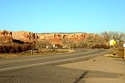
Blanding is a city in San Juan County
, Utah
, United States
. The population was 3,162 at the 2000 census, making it the most populated city in San Juan County. It was settled in the late 19th century by Mormon settlers, predominantly from the famed Hole-In-The-Rock expedition. Economic contributors include mineral processing, mining, agriculture, local commerce, tourism, and transportation.
Blanding is located near both the Navajo
and White Mesa Ute
Native American reservations, and a significant percentage of Blanding's population has family ties to these nearby cultures. Blanding is a gateway to an abundance of nearby natural and archaeological resources, including The Dinosaur Museum, Natural Bridges National Monument
, Monument Valley
and the Four Corners area, Glen Canyon National Recreation Area
(Lake Powell), Cedar Mesa archaeological and wilderness area, the San Juan River including Goosenecks State Park
, and the Needles district of Canyonlands National Park
. It is located approximately 1 hour south of the popular recreation hub of Moab
and Arches National Park
.
, offered a thousand-volume library to any town that would adopt his name. Grayson competed with Thurber, Utah (renamed Bicknell
) for the prize. Grayson was renamed Blanding after the maiden name of Bicknell's wife, and each of the towns received 500 books.
According to the United States Census Bureau
, the city has a total area of 2.4 square miles (6.1 km2), all land.
of 2000, there were 3,162 people, 886 households, and 722 families residing in the city. The population density
was 1,332.7 people per square mile (515.1/km2). There were 991 housing units at an average density of 417.7 per square mile (161.4/km2). The racial makeup of the city was 66.19% White, 0.06% African American, 28.94% Native American, 0.09% Asian, 0.03% Pacific Islander, 1.80% from other races
, and 2.88% from two or more races. Hispanic or Latino of any race were 4.05% of the population.
There were 886 households out of which 53.2% had children under the age of 18 living with them, 63.3% were married couples
living together, 14.8% had a female householder with no husband present, and 18.4% were non-families. 16.8% of all households were made up of individuals and 7.4% had someone living alone who was 65 years of age or older. The average household size was 3.46 and the average family size was 3.93.
In the city the population was spread out with 40.9% under the age of 18, 9.9% from 18 to 24, 22.4% from 25 to 44, 16.6% from 45 to 64, and 10.2% who were 65 years of age or older. The median age was 24 years. For every 100 females there were 95.9 males. For every 100 females age 18 and over, there were 88.1 males.
The median income for a household in the city was $32,991, and the median income for a family was $37,991. Males had a median income of $31,520 versus $20,391 for females. The per capita income
for the city was $12,160. About 13.9% of families and 17.8% of the population were below the poverty line, including 22.8% of those under age 18 and 3.5% of those age 65 or over.
(NAGPRA), and transportation of stolen property. That same day Blanding was the site of a related raid, and 16 local people were charged in the case. Federal agents cataloged and photographed items of interest held by these individuals, but did not seize them at that time. Commenting on the 2½-year probe, U.S. Secretary of the Interior Ken Salazar
said, "[l]et this case serve notice to anyone considering breaking these laws and trampling our nation's cultural heritage that the BLM, the Department of Justice and the federal government will track you down and bring you to justice."
On June 11, one of the suspects from Blanding, Dr. James Redd, was found dead of an apparent suicide. The following day another suspect, Steven L. Shrader of Santa Fe, New Mexico, was found dead of self-inflicted gunshot wounds.
San Juan County, Utah
As of the current census of 2010, there were 14,746 people and 4,505 households. The racial and ethnic composition of the population was 50.4% Native American, 45.8% white, 0.3% Asian, 0.2% African American and 2.3% reporting two or more races...
, Utah
Utah
Utah is a state in the Western United States. It was the 45th state to join the Union, on January 4, 1896. Approximately 80% of Utah's 2,763,885 people live along the Wasatch Front, centering on Salt Lake City. This leaves vast expanses of the state nearly uninhabited, making the population the...
, United States
United States
The United States of America is a federal constitutional republic comprising fifty states and a federal district...
. The population was 3,162 at the 2000 census, making it the most populated city in San Juan County. It was settled in the late 19th century by Mormon settlers, predominantly from the famed Hole-In-The-Rock expedition. Economic contributors include mineral processing, mining, agriculture, local commerce, tourism, and transportation.
Blanding is located near both the Navajo
Navajo Nation
The Navajo Nation is a semi-autonomous Native American-governed territory covering , occupying all of northeastern Arizona, the southeastern portion of Utah, and northwestern New Mexico...
and White Mesa Ute
Ute Tribe
The Ute are an American Indian people now living primarily in Utah and Colorado. There are three Ute tribal reservations: Uintah-Ouray in northeastern Utah ; Southern Ute in Colorado ; and Ute Mountain which primarily lies in Colorado, but extends to Utah and New Mexico . The name of the state of...
Native American reservations, and a significant percentage of Blanding's population has family ties to these nearby cultures. Blanding is a gateway to an abundance of nearby natural and archaeological resources, including The Dinosaur Museum, Natural Bridges National Monument
Natural Bridges National Monument
Natural Bridges National Monument is a U.S. National Monument located about north west of the Four Corners boundary of southeast Utah, in the western United States, at the junction of White Canyon and Armstrong Canyon, part of the Colorado River drainage...
, Monument Valley
Monument Valley
Monument Valley is a region of the Colorado Plateau characterized by a cluster of vast sandstone buttes, the largest reaching above the valley floor. It is located on the northern border of Arizona with southern Utah , near the Four Corners area...
and the Four Corners area, Glen Canyon National Recreation Area
Glen Canyon National Recreation Area
Glen Canyon National Recreation Area is a recreation and conservation unit of the National Park Service that encompasses the area around Lake Powell and lower Cataract Canyon in Utah and Arizona, covering 1,254,429 acres of mostly desert...
(Lake Powell), Cedar Mesa archaeological and wilderness area, the San Juan River including Goosenecks State Park
Goosenecks State Park
Goosenecks State Park is a state park of Utah, USA, overlooking a deep meander of the San Juan River. The park is located near the southern border of the state a short distance from Mexican Hat, Utah. Millions of years ago, the Monument Upwarp forced the river to carve incised meanders over deep...
, and the Needles district of Canyonlands National Park
Canyonlands National Park
Canyonlands National Park is a U.S. National Park located in southeastern Utah near the town of Moab and preserves a colorful landscape eroded into countless canyons, mesas and buttes by the Colorado River, the Green River, and their respective tributaries. The park is divided into four districts:...
. It is located approximately 1 hour south of the popular recreation hub of Moab
Moab, Utah
Moab is a city in Grand County, in eastern Utah, in the western United States. The population was 4,779 at the 2000 census. It is the county seat and largest city in Grand County. Moab hosts a large number of tourists every year, mostly visitors to the nearby Arches and Canyonlands National Parks...
and Arches National Park
Arches National Park
Arches National Park is a U.S. National Park in eastern Utah. It is known for preserving over 2000 natural sandstone arches, including the world-famous Delicate Arch, in addition to a variety of unique geological resources and formations....
.
Name history
First known as Grayson (after Nellie Grayson Lyman, wife of settler Joseph Lyman), the town changed its name in 1914 when a wealthy easterner, Thomas W. BicknellThomas W. Bicknell
Thomas W. Bicknell , American educator, historian, and author, lived to be 91.Bicknell, born in Barrington, Rhode Island, he was the son of a farmer, minister, state legislator, and Colonel in the Bristol County, Rhode Island Militia, Thomas would become a wealthy eastern historian and educator...
, offered a thousand-volume library to any town that would adopt his name. Grayson competed with Thurber, Utah (renamed Bicknell
Bicknell, Utah
Bicknell is a town along State Route 24 in Wayne County, Utah, United States. As of the 2000 census, the town population was 353, a slight increase over the 1990 figure of 327.-History:...
) for the prize. Grayson was renamed Blanding after the maiden name of Bicknell's wife, and each of the towns received 500 books.
Geography
Blanding is located at 37.623199°N 109.478943°W (37.623199, -109.478943) in the Four Corners area of the Colorado Plateau.According to the United States Census Bureau
United States Census Bureau
The United States Census Bureau is the government agency that is responsible for the United States Census. It also gathers other national demographic and economic data...
, the city has a total area of 2.4 square miles (6.1 km2), all land.
Demographics
As of the censusCensus
A census is the procedure of systematically acquiring and recording information about the members of a given population. It is a regularly occurring and official count of a particular population. The term is used mostly in connection with national population and housing censuses; other common...
of 2000, there were 3,162 people, 886 households, and 722 families residing in the city. The population density
Population density
Population density is a measurement of population per unit area or unit volume. It is frequently applied to living organisms, and particularly to humans...
was 1,332.7 people per square mile (515.1/km2). There were 991 housing units at an average density of 417.7 per square mile (161.4/km2). The racial makeup of the city was 66.19% White, 0.06% African American, 28.94% Native American, 0.09% Asian, 0.03% Pacific Islander, 1.80% from other races
Race (United States Census)
Race and ethnicity in the United States Census, as defined by the Federal Office of Management and Budget and the United States Census Bureau, are self-identification data items in which residents choose the race or races with which they most closely identify, and indicate whether or not they are...
, and 2.88% from two or more races. Hispanic or Latino of any race were 4.05% of the population.
There were 886 households out of which 53.2% had children under the age of 18 living with them, 63.3% were married couples
Marriage
Marriage is a social union or legal contract between people that creates kinship. It is an institution in which interpersonal relationships, usually intimate and sexual, are acknowledged in a variety of ways, depending on the culture or subculture in which it is found...
living together, 14.8% had a female householder with no husband present, and 18.4% were non-families. 16.8% of all households were made up of individuals and 7.4% had someone living alone who was 65 years of age or older. The average household size was 3.46 and the average family size was 3.93.
In the city the population was spread out with 40.9% under the age of 18, 9.9% from 18 to 24, 22.4% from 25 to 44, 16.6% from 45 to 64, and 10.2% who were 65 years of age or older. The median age was 24 years. For every 100 females there were 95.9 males. For every 100 females age 18 and over, there were 88.1 males.
The median income for a household in the city was $32,991, and the median income for a family was $37,991. Males had a median income of $31,520 versus $20,391 for females. The per capita income
Per capita income
Per capita income or income per person is a measure of mean income within an economic aggregate, such as a country or city. It is calculated by taking a measure of all sources of income in the aggregate and dividing it by the total population...
for the city was $12,160. About 13.9% of families and 17.8% of the population were below the poverty line, including 22.8% of those under age 18 and 3.5% of those age 65 or over.
Native American artifacts
On June 10, 2009, Federal officials unsealed indictments against 24 people for looting Native American artifacts on public lands. Specific charges included violating the Archaeological Resources Protection Act (ARPA), depredation and theft of government property, theft of Indian tribal property, violating the Native American Graves Protection and Repatriation ActNative American Graves Protection and Repatriation Act
The Native American Graves Protection and Repatriation Act , Pub. L. 101-601, 25 U.S.C. 3001 et seq., 104 Stat. 3048, is a United States federal law passed on 16 November 1990 requiring federal agencies and institutions that receive federal funding to return Native American "cultural items" to...
(NAGPRA), and transportation of stolen property. That same day Blanding was the site of a related raid, and 16 local people were charged in the case. Federal agents cataloged and photographed items of interest held by these individuals, but did not seize them at that time. Commenting on the 2½-year probe, U.S. Secretary of the Interior Ken Salazar
Ken Salazar
Kenneth Lee "Ken" Salazar is the current United States Secretary of the Interior, in the administration of President Barack Obama. A member of the Democratic Party, he previously served as a United States Senator from Colorado from 2005 to 2009. He and Mel Martinez were the first Hispanic U.S...
said, "[l]et this case serve notice to anyone considering breaking these laws and trampling our nation's cultural heritage that the BLM, the Department of Justice and the federal government will track you down and bring you to justice."
On June 11, one of the suspects from Blanding, Dr. James Redd, was found dead of an apparent suicide. The following day another suspect, Steven L. Shrader of Santa Fe, New Mexico, was found dead of self-inflicted gunshot wounds.
See also
- 2007 Southwest Cup2007 Southwest CupThe 2007 Southwest Cup was held in the Navajo Nation of the United States. It was the 26th time the Southwest Cup has been contested since its establishment.The Cup is a soccer tournament between tribes of Native Americans, the 2007 champions were the Zuni....
(was a host city) - Abajo MountainsAbajo MountainsThe Abajo Mountains, also called the Blue Mountains, is a small mountain range west of Monticello, Utah, south of Canyonlands National Park and north of Blanding, Utah. The mountain range is located within the Manti-La Sal National Forest...
- Arizona breccia pipe uranium mineralizationArizona breccia pipe uranium mineralizationDuring the late 1970s and through the 1980s, Mohave and Coconino County, Arizona, immediately north and south of the Grand Canyon and west of the Navajo Indian Reservation were explored for Arizona breccia pipe uranium mineralization...
- Blanding Municipal AirportBlanding Municipal AirportBlanding Municipal Airport is a city-owned public-use airport located three nautical miles south of the central business district of Blanding, a city in San Juan County, Utah, United States.- Facilities and aircraft :...
- Hovenweep National MonumentHovenweep National MonumentHovenweep National Monument is located on land in southwestern Colorado and southeastern Utah, located between Cortez, Colorado and Blanding, Utah on the Cajon Mesa of the Great Sage Plain...
- KBDXKBDXKBDX is a radio station broadcasting a Oldies format. Licensed to Blanding, Utah, USA, the station is currently owned by Kbdx Blanding L.L.C. and features programing from ABC Radio- Classic Oldies....
- Swallow's Nest (Blanding, Utah)Swallow's Nest (Blanding, Utah)The Swallow's Nest, also known as the Albert Robison Lyman Study, is a small sandstone building in Blanding, Utah. It was built in 1925 by Albert Robison Lyman as a retreat for writing...
- U.S. Route 191 in UtahU.S. Route 191 in UtahU.S. Route 191 is a major north–south state highway through the eastern part of the U.S. state of Utah. The present alignment of US-191, which stretches from Mexico to Canada, was created in 1981 through Utah...
- Utah State Route 95
- Utah State Route 262Utah State Route 262State Route 262 is a highway completely within San Juan County in southeastern Utah that connects US-191 north of Bluff to SR-162 in Montezuma Creek.-Route description:...