
Saratoga, New York
Encyclopedia
Saratoga County, New York
Saratoga County is a county located in the U.S. state of New York. As of the 2010 census, the population was 219,607. It is part of the Albany-Schenectady-Troy Metropolitan Statistical Area. The county seat is Ballston Spa...
, New York
New York
New York is a state in the Northeastern region of the United States. It is the nation's third most populous state. New York is bordered by New Jersey and Pennsylvania to the south, and by Connecticut, Massachusetts and Vermont to the east...
, United States
United States
The United States of America is a federal constitutional republic comprising fifty states and a federal district...
. The population was 5,141 at the 2000 census. It is also the commonly used, but not official, name for the neighboring and much more populous city, Saratoga Springs. The major village in the town of Saratoga is Schuylerville
Schuylerville, New York
Schuylerville is a village in Saratoga County, New York, United States. The population was 1,197 at the 2000 census. The village is named after the Schuyler family....
which is often, but not officially, called Old Saratoga. Saratoga contains a second village named Victory
Victory, Saratoga County, New York
----Victory is a village in Saratoga County, New York, United States. The population was 544 at the 2000 census. The village is located in the northeast part of the town of Saratoga, southwest of and bordering the village of Schuylerville. Victory is one of the smallest villages in New York.-...
.
Saratoga is a corruption of an Indian word from the Mohawk language
Mohawk language
Mohawk is an Iroquoian language spoken by around 2,000 people of the Mohawk nation in the United States and Canada . Mohawk has the largest number of speakers of the Northern Iroquoian languages; today it is the only one with greater than a thousand remaining...
. It was the name of Indian hunting grounds located along both sides of the Hudson River where in the Indian Tongue 'Se-rach-ta-gue' meant 'the hillside country of the quiet river.'
Saratoga is located on the eastern border of the county and is located east of Saratoga Springs, and is bordered by Saratoga Lake and the Hudson River.
History
The location was first settled at the end of the 17th Century as "Fort Saratoga". It soon became contested land between British and French colonial forces, and the village of Saratoga (now SchuylervilleSchuylerville, New York
Schuylerville is a village in Saratoga County, New York, United States. The population was 1,197 at the 2000 census. The village is named after the Schuyler family....
) was destroyed
Raid on Saratoga
The Raid on Saratoga was an attack by a French and Indian force on the settlement of Saratoga, New York on November 28, 1745, during King George's War. Led by Paul Marin de la Malgue, the allied force of 600 burned the settlement, killing about 30 and taking 60 to 100...
by the French in 1745 during King George's War
King George's War
King George's War is the name given to the operations in North America that formed part of the War of the Austrian Succession . It was the third of the four French and Indian Wars. It took place primarily in the British provinces of New York, Massachusetts Bay, New Hampshire, and Nova Scotia...
.
Saratoga was originally a district of Albany County stretching from north of the Mohawk River to Northumberland, including lands for six miles on both sides of the Hudson River. In 1775, there were three district – Ballstown, Halfmoon and Saratoga.
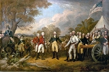
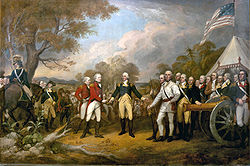
It is best known as the location that British
Kingdom of Great Britain
The former Kingdom of Great Britain, sometimes described as the 'United Kingdom of Great Britain', That the Two Kingdoms of Scotland and England, shall upon the 1st May next ensuing the date hereof, and forever after, be United into One Kingdom by the Name of GREAT BRITAIN. was a sovereign...
General John Burgoyne
John Burgoyne
General John Burgoyne was a British army officer, politician and dramatist. He first saw action during the Seven Years' War when he participated in several battles, mostly notably during the Portugal Campaign of 1762....
surrendered to American
Continental Army
The Continental Army was formed after the outbreak of the American Revolutionary War by the colonies that became the United States of America. Established by a resolution of the Continental Congress on June 14, 1775, it was created to coordinate the military efforts of the Thirteen Colonies in...
General Horatio Gates
Horatio Gates
Horatio Lloyd Gates was a retired British soldier who served as an American general during the Revolutionary War. He took credit for the American victory at the Battle of Saratoga – Benedict Arnold, who led the attack, was finally forced from the field when he was shot in the leg – and...
at the end of the Battles of Saratoga on October 17, 1777, often cited as the turning point for the United States during the American Revolutionary War
American Revolutionary War
The American Revolutionary War , the American War of Independence, or simply the Revolutionary War, began as a war between the Kingdom of Great Britain and thirteen British colonies in North America, and ended in a global war between several European great powers.The war was the result of the...
. Much of the fighting took place in the town of Stillwater
Stillwater (town), New York
Stillwater is a town in Saratoga County, New York, United States. The population was 7,522 at the 2000 census. The town contains a village called Stillwater...
to the south however the final seven days of the Battles and the actual sword surrender took place in Saratoga (Schuylerville).
In 1788, an act was passed organizing towns in place of districts and Stillwater was created from the Saratoga District, making four towns in what would become Saratoga County. These four mother towns were subdivided into the present nineteen towns. The original town of Saratoga included the modern day towns of Easton, Northumberland, Moreau, Wilton, portions of Greenfield and Corinth, and the city of Saratoga Springs. The first loss of territory was in 1789 to the town of Easton
Easton, New York
Easton is a town in southwestern Washington County, New York, United States along the county's western boundary. It is part of the Glens Falls Metropolitan Statistical Area. The town population was 2,259 at the 2000 census. The town is named after Easton, Connecticut...
(now in Washington County
Washington County, New York
Washington County is a county located in the U.S. state of New York. It is part of the Glens Falls, New York, Metropolitan Statistical Area. As of the 2010 census, the population was 63,216. It was named for the Revolutionary War general George Washington...
). In 1798, the towns of Corinth
Corinth (town), New York
Corinth is a town in Saratoga County, New York, USA. The population was 5,985 at the 2000 census. The town contains a village also named Corinth. The town is on the northeast border of the county, north of Saratoga Springs. It regards itself as the "snowshoe capital of the world." The town is named...
, Greenfield
Greenfield, New York
Greenfield is a town in Saratoga County, New York, United States. The population was 7,362 at the 2000 census. The town is named after Greenfield, New Hampshire.The Town of Greenfield is an interior town...
, Northumberland
Northumberland, New York
Northumberland is a town in Saratoga County, New York, United States. The population was 4,603 at the 2000 census. The name comes from a location in Great Britain....
, Moreau
Moreau, New York
Moreau is a town in Saratoga County, New York, United States. The population was 13,826 at the 2000 census. The town is located in the northeast part of the county, north of Saratoga Springs. Moreau is named after Jean Victor Moreau, a French general, who visited the area just before the town was...
, and Wilton
Wilton, New York
Wilton is a town in Saratoga County, New York, United States. The population was 12,511 at the 2000 census.The Town of Wilton is in the northeastern part of the county, northeast of Saratoga Springs, which it borders.-History:...
split from the town of Saratoga. In 1805 a narrow strip in the southwestern part of Saratoga was annexed to the town of Malta. In 1819, the town of Saratoga Springs was formed from the rest of the western part of the town of Saratoga. Later this would become the city of Saratoga Springs
Saratoga Springs, New York
Saratoga Springs, also known as simply Saratoga, is a city in Saratoga County, New York, United States. The population was 26,586 at the 2010 census. The name reflects the presence of mineral springs in the area. While the word "Saratoga" is known to be a corruption of a Native American name, ...
.
The Saratoga Race Course
Saratoga Race Course
Saratoga Race Course is a Thoroughbred horse racing track in Saratoga Springs, New York, United States. It opened on August 3, 1863, and is the oldest organized sporting venue of any kind in the United States. It is typically open for racing from late July through early September.-History:John...
in the adjoining city of Saratoga Springs is the oldest operating sports venue in the country, but is often mistakenly associated to the town of Saratoga.
According to the United States Census Bureau
United States Census Bureau
The United States Census Bureau is the government agency that is responsible for the United States Census. It also gathers other national demographic and economic data...
, the town has a total area of 42.9 square miles (111.1 km²), of which, 40.7 square miles (105.4 km²) of it is land and 2.2 square miles (5.7 km²) of it (5.22%) is water.
The town line is formed by the Hudson River
Hudson River
The Hudson is a river that flows from north to south through eastern New York. The highest official source is at Lake Tear of the Clouds, on the slopes of Mount Marcy in the Adirondack Mountains. The river itself officially begins in Henderson Lake in Newcomb, New York...
and is the border of Washington County
Washington County, New York
Washington County is a county located in the U.S. state of New York. It is part of the Glens Falls, New York, Metropolitan Statistical Area. As of the 2010 census, the population was 63,216. It was named for the Revolutionary War general George Washington...
. Fish Creek, a tributary
Tributary
A tributary or affluent is a stream or river that flows into a main stem river or a lake. A tributary does not flow directly into a sea or ocean...
of the Hudson River, is the outflow of Saratoga Lake.
US Route 4 (Turning Point Trail) follows the Hudson River along the eastern part of the town. New York State Route 29
New York State Route 29
New York State Route 29 is a state highway extending for across the eastern portion of the U.S. state of New York. The western terminus of the route is at NY 28 and NY 169 in Middleville, Herkimer County. The eastern terminus of the route is at NY 22 just south of Salem,...
(General Philip Schuyler Commemorative Highway) is an east-west highway, intersecting US-4 at Schuylerville. New York State Route 32
New York State Route 32
New York State Route 32 is a north–south state highway that extends for through the Hudson Valley and Capital District regions of the U.S. state of New York. It is a two-lane surface road for nearly its entire length, with few divided and no limited-access sections. From Harriman to Albany,...
is a north-south highway partly conjoined with US-4 near Schuylerville.
Demographics
As of the censusCensus
A census is the procedure of systematically acquiring and recording information about the members of a given population. It is a regularly occurring and official count of a particular population. The term is used mostly in connection with national population and housing censuses; other common...
of 2000, there were 5,141 people, 2,026 households, and 1,387 families residing in the town. The population density
Population density
Population density is a measurement of population per unit area or unit volume. It is frequently applied to living organisms, and particularly to humans...
was 126.4 people per square mile (48.8/km²). There were 2,286 housing units at an average density of 56.2 per square mile (21.7/km²). The racial makeup of the town was 97.80% White, 0.97% African American, 0.06% Native American, 0.16% Asian, 0.06% Pacific Islander, 0.23% from other races
Race (United States Census)
Race and ethnicity in the United States Census, as defined by the Federal Office of Management and Budget and the United States Census Bureau, are self-identification data items in which residents choose the race or races with which they most closely identify, and indicate whether or not they are...
, and 0.72% from two or more races. Hispanic or Latino of any race were 1.17% of the population.
There were 2,026 households out of which 31.5% had children under the age of 18 living with them, 54.9% were married couples living together, 9.4% had a female householder with no husband present, and 31.5% were non-families. 24.5% of all households were made up of individuals and 9.7% had someone living alone who was 65 years of age or older. The average household size was 2.51 and the average family size was 3.00.
In the town the population was spread out with 24.6% under the age of 18, 6.9% from 18 to 24, 29.9% from 25 to 44, 25.7% from 45 to 64, and 12.9% who were 65 years of age or older. The median age was 38 years. For every 100 females there were 99.7 males. For every 100 females age 18 and over, there were 96.2 males.
The median income for a household in the town was $42,727, and the median income for a family was $48,482. Males had a median income of $33,178 versus $27,654 for females. The per capita income
Per capita income
Per capita income or income per person is a measure of mean income within an economic aggregate, such as a country or city. It is calculated by taking a measure of all sources of income in the aggregate and dividing it by the total population...
for the town was $21,716. About 6.1% of families and 7.3% of the population were below the poverty line, including 6.8% of those under age 18 and 6.2% of those age 65 or over.
Communities and locations in Saratoga
- Burgoyne – A hamlet in the north part of the town. It is named after the commander of the British forces at the Battles of Saratoga.
- Cedar Bluffs – A hamlet on the east shore of Saratoga Lake.
- Coveville – A hamlet along the Hudson River, located by The Cove on US-4.
- The Cove – An arm of the Hudson River.
- Deans Corners – A hamlet in the northwest quarter of the town located at the junction of County Roads 67 and 70.
- Gates – A hamlet in the north part of the town. It is named after the commander of the American forces at the Battles of Saratoga.
- Grangerville – A hamlet near the north town line, west of Schuylerville on NY-29.
- Maple Shade – A hamlet on the east shore of Saratoga Lake, south of Cedar Bluffs.
- Meyer Corners – A location in the southwest part of Saratoga at the intersection of County Roads 70 and 71.
- Quaker Springs – A hamlet in the south part of the town on NY-32.
- Saratoga Lake – (1) A hamlet at the north end of (2) a lakeLakeA lake is a body of relatively still fresh or salt water of considerable size, localized in a basin, that is surrounded by land. Lakes are inland and not part of the ocean and therefore are distinct from lagoons, and are larger and deeper than ponds. Lakes can be contrasted with rivers or streams,...
named Saratoga Lake. - Saratoga National Historical ParkSaratoga National Historical ParkSaratoga National Historical Park is a United States National Historical Park located in eastern New York State forty miles north of Albany, New York.-Description:...
– An national historical park that includes the Schuyler House, Saratoga Monument, Victory Woods and the Battlefield (in Stillwater). - SchuylervilleSchuylerville, New YorkSchuylerville is a village in Saratoga County, New York, United States. The population was 1,197 at the 2000 census. The village is named after the Schuyler family....
– A village in the northeast part of the town, located on US-4, NY-29&32, Champlain Canal, and Hudson River. - VictoryVictory, Saratoga County, New York----Victory is a village in Saratoga County, New York, United States. The population was 544 at the 2000 census. The village is located in the northeast part of the town of Saratoga, southwest of and bordering the village of Schuylerville. Victory is one of the smallest villages in New York.-...
– A village in the northeast part of the town, located on NY-32. - Victory Mills – A post office name and the name of the last major mill in the village of Victory.