

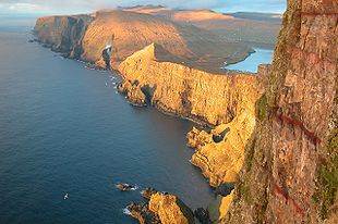
Beinisvørð
Encyclopedia
Suðuroy
Suðuroy is the southernmost of the Faroe Islands. The island covers 163.7 km². In 2010 there were 4763 inhabitants, but there has been a gradual decline in the population numbers ever since the 1950s....
, Faroe Islands
Faroe Islands
The Faroe Islands are an island group situated between the Norwegian Sea and the North Atlantic Ocean, approximately halfway between Scotland and Iceland. The Faroe Islands are a self-governing territory within the Kingdom of Denmark, along with Denmark proper and Greenland...
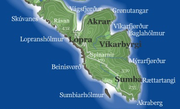
, the highest sea cliff in Suðuroy. It is located between the villages of Lopra
Lopra
Lopra is a village on the island of Suðuroy with the postal code FO 926. In 2009 its population was 96. It is located in the Municipality of Sumba along with the villages Akrar, Sumba and Víkarbyrgi, constituting the southernmost settlements in the Faroe Islands...
and Sumba
Sumba, Faroe Islands
Sumba is the southernmost place of the Faroe Islands on the island of Suðuroy. It is located in the Sumbiar municipality.The municipality has 385 inhabitants. 258 of these people are living in Sumba. The other villages in the Municipality of Sumba are: Lopra , Akrar , Víkarbyrgi .Sumba is known for...
. Beinisvørð has vertical cliffs facing the sea and a green slope down towards the village of Sumba. The triangular top of Beinisvørð is visible from many places in Suðuroy, including Lopra, Nes
Nes, Vágur
Nes is a village on the Faroese island of Suðuroy located in the municipality of Vágur . It is located west of Porkeri and east of Vágur. Its postal code is FO 925. It should not be confused with another village by the same name on Eysturoy . There is another village in Suðuroy with the same...
and Marknoyri, the easternmost part of Vágur
Vágur
Vágur meaning Bay is a town on the Faroe Islands of Suðuroy, it is situated on the east coast of the island on the Vágsfjørður fjord, and dates from the fourteenth century. Expansion has meant that the nearby town of Nes is now a suburb of Vágur...
. In clear weather it is also visible from Smyril
Smyril
The Smyril is a passenger / car ferry owned and operated by the Faroese transport company Strandfaraskip Landsins. She is the largest ferry in the fleet and the 5th vessel to carry the name Smyril, which is the Faroese word for Merlin....
M/F just before she enters the fjord of Trongisvágur
Trongisvágur
Trongisvágur is a village on the island of Suduroy in the Faroe Islands.*Population: 415*Postal code : FO 826*Location: *Municipality: Tvoroyrar...
, Trongisvágsfjørður. Men from Sumba used to rappel down the steep mountain side of Beinisvørð on bird lines (it is called "síging"; one man hangs on a thick rope, while several men hold it at the top) in order to catch sea birds and to collect eggs. Both birds and their eggs were important food for the people of Sumba in the past. Several men have been killed while doing this; sometimes a stone fell on a man's head, fatally injuring him. In 1975 a big avalanche at Beinisvørð destroyed numerous bird habitats and landmarks.
Beinisvørð in Faroese poetry
At least two famous FaroeseFaroe Islands
The Faroe Islands are an island group situated between the Norwegian Sea and the North Atlantic Ocean, approximately halfway between Scotland and Iceland. The Faroe Islands are a self-governing territory within the Kingdom of Denmark, along with Denmark proper and Greenland...
poets have mentioned Beinisvørð in poems. Poul F. Joensen (born 1898 in Sumba
Sumba, Faroe Islands
Sumba is the southernmost place of the Faroe Islands on the island of Suðuroy. It is located in the Sumbiar municipality.The municipality has 385 inhabitants. 258 of these people are living in Sumba. The other villages in the Municipality of Sumba are: Lopra , Akrar , Víkarbyrgi .Sumba is known for...
, died 1970 in Froðba
Froðba
Froðba is a village located farthest out on the north brink of Trongisvágsfjørður, an inlet on the east coast of the island of Suðuroy in the Faroe Islands. The village has eventually merged with the harbour-city of Tvøroyri....
) often mentioned Beinisvørð as the guardian spirit of the country. A Faroese singer and composer from Klaksvík, Hanus G. Johansen, set several of these poems to music and after that they became very popular and well known amongst Faroese of all ages. Janus Djurhuus
Janus Djurhuus
Jens Hendrik Oliver Djurhuus, called Janus Djurhuus, was the first modern Faroese poet...
(born 1881 in Tórshavn
Tórshavn
Tórshavn is the capital and largest town of the Faroe Islands. It is located in the southern part on the east coast of Streymoy. To the north west of the town lies the high mountain Húsareyn, and to the southwest, the high Kirkjubøreyn...
, died 1948) uses it as a symbol of Faroese independence in "Heimferð Nólsoyar Páls".
Tourism
Tourists who visit Suðuroy often wish to see Beinisvørð. It can be seen from several locations, the nearest being Hesturin, near the one-lane road between Lopra and Sumba. There is also a road tunnel from Lopra to Sumba. For busses it is best to go to Sumba first and from there up to Hesturin (near the antenna), and on the way back turn the bus on Hesturin and go back to Sumba. The road from Hesturin to Lopra has many curves and can be difficult for busses to drive on. Another option is from Lopranseiði, which is west of Lopra; turn right just before entering the village; a road goes almost all the way to the coast. It is not far from the main road, less than 1 km. Beinisvørð can also be seen at a greater distance from EggjarnarEggjarnar
Eggjarnar is a place south of the village Vágur on Suðuroy island in the Faroe Islands, which is known for its scenic view point to the sea cliffs of the southern part of Suðuroy all the way to Beinisvørð in the south and to Vágseiði and Gjógvaráfjall in the north.- The Loran-C Station :During...
, just south of Vágur
Vágur
Vágur meaning Bay is a town on the Faroe Islands of Suðuroy, it is situated on the east coast of the island on the Vágsfjørður fjord, and dates from the fourteenth century. Expansion has meant that the nearby town of Nes is now a suburb of Vágur...
. A one-lane road goes to some 25 m from the cliff's edge at Eggjarnar.
External links
- Photos of Beinisvørð at Flickr.com.
- Færøsk 50-kroneseddel, Nationalbanken.dk (The National Bank of Denmark): Beinisvørð as a motif on the Faroese 50 Kroner note
- Sumba Municipality