
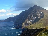
Croaghaun
Encyclopedia
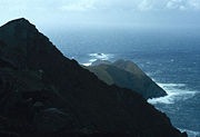
Croaghaun is a mountain
Mountain
Image:Himalaya_annotated.jpg|thumb|right|The Himalayan mountain range with Mount Everestrect 58 14 160 49 Chomo Lonzorect 200 28 335 52 Makalurect 378 24 566 45 Mount Everestrect 188 581 920 656 Tibetan Plateaurect 250 406 340 427 Rong River...
in County Mayo
County Mayo
County Mayo is a county in Ireland. It is located in the West Region and is also part of the province of Connacht. It is named after the village of Mayo, which is now generally known as Mayo Abbey. Mayo County Council is the local authority for the county. The population of the county is 130,552...
, Ireland
Ireland
Ireland is an island to the northwest of continental Europe. It is the third-largest island in Europe and the twentieth-largest island on Earth...
. At 688 metres (2,257 ft), it has the highest cliff
Cliff
In geography and geology, a cliff is a significant vertical, or near vertical, rock exposure. Cliffs are formed as erosion landforms due to the processes of erosion and weathering that produce them. Cliffs are common on coasts, in mountainous areas, escarpments and along rivers. Cliffs are usually...
s in Ireland and the second highest sea cliffs in Europe
Europe
Europe is, by convention, one of the world's seven continents. Comprising the westernmost peninsula of Eurasia, Europe is generally 'divided' from Asia to its east by the watershed divides of the Ural and Caucasus Mountains, the Ural River, the Caspian and Black Seas, and the waterways connecting...
(after Hornelen
Hornelen
Hornelen is a mountain in the municipality of Bremanger, in Sogn og Fjordane county, Norway. At , it is the highest sea cliff in Europe, and has for a long time been used as a landmark for naval navigation. The horizontal distance from the summit to the sea shore is approximately...
, Norway
Norway
Norway , officially the Kingdom of Norway, is a Nordic unitary constitutional monarchy whose territory comprises the western portion of the Scandinavian Peninsula, Jan Mayen, and the Arctic archipelago of Svalbard and Bouvet Island. Norway has a total area of and a population of about 4.9 million...
).
Croaghaun is the most westerly peak of Achill Island
Achill Island
Achill Island in County Mayo is the largest island off the coast of Ireland, and is situated off the west coast. It has a population of 2,700. Its area is . Achill is attached to the mainland by Michael Davitt Bridge, between the villages of Gob an Choire and Poll Raithní . A bridge was first...
, and its highest mountain. Its cliffs lie on the northern slope of the mountain. The cliffs at Croaghaun can only be seen by hiking
Hiking
Hiking is an outdoor activity which consists of walking in natural environments, often in mountainous or other scenic terrain. People often hike on hiking trails. It is such a popular activity that there are numerous hiking organizations worldwide. The health benefits of different types of hiking...
around or to the summit of the mountain, or from the sea
Sea
A sea generally refers to a large body of salt water, but the term is used in other contexts as well. Most commonly, it means a large expanse of saline water connected with an ocean, and is commonly used as a synonym for ocean...
. They are part of a sequence of sheer rock
Rock (geology)
In geology, rock or stone is a naturally occurring solid aggregate of minerals and/or mineraloids.The Earth's outer solid layer, the lithosphere, is made of rock. In general rocks are of three types, namely, igneous, sedimentary, and metamorphic...
faces which start south of Keem Bay
Keem Bay
Keem Bay is located past Dooagh village in the west of Achill Island in County Mayo, Ireland. It contains a Blue Flag beach. The bay was formerly the site of a basking shark fishery. There is an old British army lookout post on the top of Moyteoge to the bay's south. To the west is an old booley...
and loop around the uninhabited northwest of the island
Island
An island or isle is any piece of sub-continental land that is surrounded by water. Very small islands such as emergent land features on atolls can be called islets, cays or keys. An island in a river or lake may be called an eyot , or holm...
, by Achill Head and Saddle Head, and east to Slievemore
Slievemore
Slievemore is the second highest peak on Achill Island, in County Mayo, Ireland. Its elevation is 671 metres.-Archaeology:* Achill Archaeological Field School is based at the Achill Archaeology Centre in Dooagh. It was founded in 1991 and is a training school for students of archaeology and...
, occasionally dropping vertically into the waters of the Atlantic Ocean
Atlantic Ocean
The Atlantic Ocean is the second-largest of the world's oceanic divisions. With a total area of about , it covers approximately 20% of the Earth's surface and about 26% of its water surface area...
. The views from the top of the cliffs are breathtaking, and the unusual corries
Cirque
Cirque may refer to:* Cirque, a geological formation* Makhtesh, an erosional landform found in the Negev desert of Israel and Sinai of Egypt*Cirque , an album by Biosphere* Cirque Corporation, a company that makes touchpads...
and unique rock types make this location desirable to hikers. The cliffs are not reachable by car and visitors must either park at Keem beach and trek from there; park at the supply lake on the way to Keem bay; or go by boat.
The Croaghaun cliffs are home to two families of peregrine falcons (RTÉ, 2008). September and October are the best time to see the fastest creatures on earth here, as they teach their young to fly. Metamorphic, quartz laden gems may be observed, along with Mediterranean heathers and the waters of the Atlantic. It is common to see shoals of bottle-nosed dolphins, and basking sharks, once a source of revenue for Achill Island (BBC, 2009). Porpoises are found in large numbers. Killer whales, humpbacks, and other whales have been sighted.