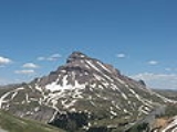
Uncompahgre Peak
Encyclopedia
Uncompahgre Peak is the sixth highest mountain peak in the U.S. state
of Colorado
and is the highest peak of the San Juan Mountains
. It is located in the Uncompahgre Wilderness
in the northern San Juans, in northern Hinsdale County
approximately 7 miles (11 km) west of the town of Lake City
.
Uncompahgre peak has a broad summit plateau, rising about 1500 ft (457.2 m) above the broad surrounding alpine basins. The south, east and west sides are not particularly steep, but the north face boasts a 700 ft (213.4 m) cliff
. Like all peaks in the San Juan Mountains, Uncompahgre is of volcanic origin, but is not a volcano. The rock is of poor quality for climbing, precluding an ascent of the north face.
The most popular route for climbing Uncompahgre Peak is Uncompahgre National Forest
Service Trail Number 239, which starts from the end of the Nellie Creek Road, east-southeast of the peak. The Nellie Creek Road is a four wheel drive
road accessed from the Henson Creek Road, about 4 miles (6.4 km) west of Lake City. The trail to the summit is a strenuous hike rising 2919 ft (890 m) in elevation in about 3.5 mi (6 km). It accesses the summit in a winding ascent, starting from the east, passing over a south-trending ridge, and finishing on the west slopes of the summit plateau.
U.S. state
A U.S. state is any one of the 50 federated states of the United States of America that share sovereignty with the federal government. Because of this shared sovereignty, an American is a citizen both of the federal entity and of his or her state of domicile. Four states use the official title of...
of Colorado
Colorado
Colorado is a U.S. state that encompasses much of the Rocky Mountains as well as the northeastern portion of the Colorado Plateau and the western edge of the Great Plains...
and is the highest peak of the San Juan Mountains
San Juan Mountains
The San Juan Mountains are a high and rugged mountain range in the Rocky Mountains in southwestern Colorado. The area is highly mineralized and figured in the gold and silver mining industry of early Colorado. Major towns, all old mining camps, include Creede, Lake City, Silverton, Ouray, and...
. It is located in the Uncompahgre Wilderness
Uncompahgre Wilderness
The Uncompahgre Wilderness is a U.S. Wilderness Area in southwest Colorado comprising 102,721 acres...
in the northern San Juans, in northern Hinsdale County
Hinsdale County, Colorado
Hinsdale County is the least densely populated of the 64 counties of the State of Colorado of the United States. The county population was 790 at U.S. Census 2000. The county seat and the only municipality in the county is the Town of Lake City. Hinsdale County is named for George A. Hinsdale, a...
approximately 7 miles (11 km) west of the town of Lake City
Lake City, Colorado
The Town of Lake City is a Statutory Town that is the county seat of, and the only incorporated municipality in, Hinsdale County, Colorado, United States. The town population was 375 at the U.S. Census 2000...
.
Uncompahgre peak has a broad summit plateau, rising about 1500 ft (457.2 m) above the broad surrounding alpine basins. The south, east and west sides are not particularly steep, but the north face boasts a 700 ft (213.4 m) cliff
Cliff
In geography and geology, a cliff is a significant vertical, or near vertical, rock exposure. Cliffs are formed as erosion landforms due to the processes of erosion and weathering that produce them. Cliffs are common on coasts, in mountainous areas, escarpments and along rivers. Cliffs are usually...
. Like all peaks in the San Juan Mountains, Uncompahgre is of volcanic origin, but is not a volcano. The rock is of poor quality for climbing, precluding an ascent of the north face.
The most popular route for climbing Uncompahgre Peak is Uncompahgre National Forest
Uncompahgre National Forest
Uncompahgre National Forest is a U.S. National Forest covering 955,229 acres in parts of Montrose, Mesa, San Miguel, Ouray, Gunnison, San Juan, and Delta Counties in western Colorado...
Service Trail Number 239, which starts from the end of the Nellie Creek Road, east-southeast of the peak. The Nellie Creek Road is a four wheel drive
Four Wheel Drive
The Four Wheel Drive Auto Company, more often known as Four Wheel Drive or just FWD, was founded in 1909 in Clintonville, Wisconsin, as the Badger Four-Wheel Drive Auto Company by Otto Zachow and William Besserdich.-History:...
road accessed from the Henson Creek Road, about 4 miles (6.4 km) west of Lake City. The trail to the summit is a strenuous hike rising 2919 ft (890 m) in elevation in about 3.5 mi (6 km). It accesses the summit in a winding ascent, starting from the east, passing over a south-trending ridge, and finishing on the west slopes of the summit plateau.
See also
- List of Colorado fourteeners
- Mountain peaks of ColoradoMountain peaks of ColoradoThis article comprises three sortable tables of the major mountain peaks of the U.S. State of Colorado.Topographic elevation is the vertical distance above the reference geoid, a precise mathematical model of the Earth's sea level as an equipotential gravitational surface...
- Mountain ranges of ColoradoMountain ranges of ColoradoThe following table lists the major mountain ranges of the U.S. State of Colorado.-Mountain Ranges:-See also:*4000 meter peaks of Colorado*Colorado mountain passes*Geography of Colorado*Lists of mountains*Mountain peaks of Colorado...

