
Stawamus Chief
Encyclopedia
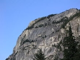
The Stawamus Chief is a granite dome
located adjacent to the town of Squamish, British Columbia
. It towers over 700 m (2,297 ft) above the waters of nearby Howe Sound
. It is often claimed to be the "second largest granite monolith
in the world." The Sḵwxwú7mesh, indigenous
people from this area, consider the Chief to be a place of spiritual significance. The mountain gets its name from their village near its foot, St'a7mes
(Stawamus).
was established by the British Columbia
Ministry of the Environment. The park is over 5 square kilometres in area and encompasses not only the Chief but also the Stawamus Squaw
, a slightly smaller granitic dome located a short distance to the north-east. This was renamed Slhanay in 2009 due to the derogatory implications of the word "Squaw". Also featured in the park are a walk-in campground and a number of maintained hiking
trails which lead through the forest of the Chief's "backside" to several summit
areas.
In the spring of 2009, a new pedestrian bridge was opened across the highway. It provides access to the park from a new southbound parking lot in addition to linking the climbing areas of The Chief with those on the granite faces of Malamute Bluffs. This bridge was built as part of the Winter Olympic upgrades of the Sea to Sky Highway?
of a granitic rock (granodiorite
) that was initially formed in the early Cretaceous
(approximately 100 million years ago) by the slow cooling and solidification of molten magma
deep below the surface of the Earth. Exhumation of the granite body probably occurred mostly by erosion
of overlying rocks over tens of millions of years, with glacial erosion processes dominating exhumation over the last 2.5 million years. Once exposed at the surface, the original granite body was shaped by glacial erosion, which is responsible for the tall steep walls that define the Chief, as well as the excavation of Howe Sound, a fjord
. Classic hallmarks of glacial erosion are ubiquitous, especially polished, striated surfaces. Polish and striations observable at the very summit of the formation require that, at the peak of glaciation, the entire formation was buried under a substantial thickness of ice.
The striking gullies
that separate and define the three summits of the Chief are the result of fracturing and mass-wasting of large blocks along a series of vertical, and roughly north-south oriented deep seated fracture sets (joints).
The Chief may be the root of an extinct volcano because no volcanic activity has occurred in the Squamish area from about 86 million years ago to the beginning of Garibaldi Volcanic Belt
volcanism
about 2-3 million years ago. In the Squamish area, Garibaldi Volcanic Belt volcanism ceased during or shorty after the end of the last ice age
.
 The Chief measures approximately three square kilometres. In summary, there are several summits separated by several deep gullies. Steep cliffs separate the summits from the forest floor in many places, especially the western faces.
Each summit features an expanse of fine glacier-polished
granite and the promise of incredible views in all directions. Third Peak is a bit more remote and isolated and is less popular with tourists.
An additional summit area lies to the north of all the summits. This area is called the Zodiac Summit. Although it can be considered a sub-summit of Third Peak, it is perhaps the most isolated area of the Chief. No proper trail leads to the Zodiac Summit; there are only faint tracks here and there among the trees.
trails. These trails are steep and rugged. In fact, in several high places there are short sections of "trail" that are so steep and/or slippery, that chains and ladders have been bolted to the rock for aid.
. They were apparently excavated primarily by glacier action.
There is an additional smaller gully near the south end of the Chief called Bullethead Gully which somewhat separates the Bulletheads region from the rest of the Chief. This gully is very bushy and is much less dramatic than the main gullies mentioned above.
 The Apron is a vast sweep of lower-angle rock which rises like a wedge from the highway to about halfway up the Grand Wall near the Chief's approximate centre. There it meets with a rising ridge of rock known as the Squamish Buttress, and promptly terminates in the great chasm known as the South Gully.
The Chief's rock faces, especially the Grand Wall, exhibit the unique textural patterns which result from the process of granitic exfoliation. This is the natural means by which large, high-quality granite formations weather, erode, and age. Rather than crumbling and slowly wearing away, large flakes of granite tend to shear off and drop from the face in layers. On impact with the ground below, the shattered flakes become boulders and talus
.
Sometimes a flake will partially split away while remaining attached to the rock face. An excellent example of a partially detached flake on the Chief is the renowned Split Pillar on the Grand Wall. The Chief's rock faces are characterized by varied rock features including overhanging roofs, splitter cracks, rock chimneys, dihedrals, ledges, platforms, and lower angle slabs.
 This feature divides the Grand Wall from the Dihedral Wall to the south. This feature is considerably younger than the pale granodiorite rock surrounding it. It formed by the splitting of the solid granodiorite along a vertical fracture, which created a conduit for basalt
and andesite
magmas, which may have fed volcanoes on the surface above the then-buried granitic rock. These younger magmas cooled quite quickly, which results in a very fine grained, almost glassy texture. The resulting dyke
is now clearly visible from the Chief's main parking area.
common in the area. Typical tree species are Douglas Fir, Western Red Cedar, Sitka Spruce
, and Alder
.
s. Once themselves part of the Chief, these boulders form groups which have been carefully explored by bouldering
enthusiasts. Some of the boulders are so large as to seem like small cliffs in their own right. The largest is the Cacodemon Boulder at the base of the Grand Wall, an individual chunk of rock as big as a small apartment building.
destination. Squamish is sometimes referred to as "Yosemite
North". In terms of structure, composition, and quality of the granitic rock, the Chief reportedly resembles Half Dome
in the Yosemite Valley.
Kevin McLane, longtime rock climber and Squamish guidebook author, describes climbing at the Chief thus: "immense vertical walls, long cool slabs, sinuous dykes
, and beautiful cracks offer a variety of climbing that is hard to match anywhere." Almost every style of rock climbing at almost every possible skill level can be practiced here, including Traditional climbing
, sport climbing
, aid climbing
, and bouldering
. Since the Chief is practically at sea-level, the only climbing styles not normally represented are alpine
climbing and ice climbing
, though ample opportunities exist for these pursuits in the surrounding Coast Mountains.
Rock climber Peter Croft began what continues to be a long and illustrious climbing career in Squamish in the late 1970s. He astounded the climbing community by putting up a number of bold new free climbing
routes on the Chief which, at the time, pushed the limits of what people thought was possible. More recently, Brad Zdanivsky became the first quadriplegic ever to reach the summit on 31 July 2005. In the summer of 2006, Sonnie Trotter established what is considered to be the hardest traditionally protected single rock pitch in North America, and possibly the world: Cobra Crack (5.14).
Granite dome
A granite dome is a dome of granite, formed by exfoliation.-Formation:Granite forms plutons of igneous rock several kilometers below the surface as magma slowly cools and crystallizes. The granite is under great overhead pressure....
located adjacent to the town of Squamish, British Columbia
Squamish, British Columbia
Squamish is a community and a district municipality in the Canadian province of British Columbia, located at the north end of Howe Sound on the Sea to Sky Highway...
. It towers over 700 m (2,297 ft) above the waters of nearby Howe Sound
Howe Sound
Howe Sound is a roughly triangular sound, actually a network of fjords situated immediately northwest of Vancouver.-Geography:Howe Sound's mouth at the Strait of Georgia is situated between West Vancouver and the Sunshine Coast. The sound is triangular shaped, open on its southeast towards the...
. It is often claimed to be the "second largest granite monolith
Monolith
A monolith is a geological feature such as a mountain, consisting of a single massive stone or rock, or a single piece of rock placed as, or within, a monument...
in the world." The Sḵwxwú7mesh, indigenous
Indigenous peoples of the Pacific Northwest Coast
The Indigenous peoples of the Pacific Northwest Coast are the pre-Columbian inhabitants of the Pacific Northwest Coast, their descendants, and many ethnic groups who identify with those historical peoples. They are now situated within the Canadian Province of British Columbia and the U.S...
people from this area, consider the Chief to be a place of spiritual significance. The mountain gets its name from their village near its foot, St'a7mes
St'a7mes
St'a7mes is a village/reserve of the Indigenous Sḵwxwú7mesh, located near Squamish, British Columbia. One of the smaller villages, it houses many members of their nation. The village is also the center for administrative, educational and health services in the Upper Squamish region. The...
(Stawamus).
The park
In 1997, the Stawamus Chief Provincial ParkStawamus Chief Provincial Park
Stawamus Chief Provincial Park is a provincial park in British Columbia, Canada established in 1997. It includes hiking, rock climbing, camping, and scenic views across Howe Sound and Mount Garibaldi to the north...
was established by the British Columbia
British Columbia
British Columbia is the westernmost of Canada's provinces and is known for its natural beauty, as reflected in its Latin motto, Splendor sine occasu . Its name was chosen by Queen Victoria in 1858...
Ministry of the Environment. The park is over 5 square kilometres in area and encompasses not only the Chief but also the Stawamus Squaw
Stawamus Squaw
The Stawamus Squaw is a large dome of granitic rock located adjacent to the town of Squamish, British Columbia. Although the Squaw is indeed an impressive geological formation, it tends to be overshadowed by the Stawamus Chief, a much larger granitic dome located immediately south-west.The use of...
, a slightly smaller granitic dome located a short distance to the north-east. This was renamed Slhanay in 2009 due to the derogatory implications of the word "Squaw". Also featured in the park are a walk-in campground and a number of maintained hiking
Hiking
Hiking is an outdoor activity which consists of walking in natural environments, often in mountainous or other scenic terrain. People often hike on hiking trails. It is such a popular activity that there are numerous hiking organizations worldwide. The health benefits of different types of hiking...
trails which lead through the forest of the Chief's "backside" to several summit
Summit (topography)
In topography, a summit is a point on a surface that is higher in elevation than all points immediately adjacent to it. Mathematically, a summit is a local maximum in elevation...
areas.
In the spring of 2009, a new pedestrian bridge was opened across the highway. It provides access to the park from a new southbound parking lot in addition to linking the climbing areas of The Chief with those on the granite faces of Malamute Bluffs. This bridge was built as part of the Winter Olympic upgrades of the Sea to Sky Highway?
Geology
The Chief is part of a medium-sized plutonPluton
A pluton in geology is a body of intrusive igneous rock that crystallized from magma slowly cooling below the surface of the Earth. Plutons include batholiths, dikes, sills, laccoliths, lopoliths, and other igneous bodies...
of a granitic rock (granodiorite
Granodiorite
Granodiorite is an intrusive igneous rock similar to granite, but containing more plagioclase than orthoclase-type feldspar. Officially, it is defined as a phaneritic igneous rock with greater than 20% quartz by volume where at least 65% of the feldspar is plagioclase. It usually contains abundant...
) that was initially formed in the early Cretaceous
Cretaceous
The Cretaceous , derived from the Latin "creta" , usually abbreviated K for its German translation Kreide , is a geologic period and system from circa to million years ago. In the geologic timescale, the Cretaceous follows the Jurassic period and is followed by the Paleogene period of the...
(approximately 100 million years ago) by the slow cooling and solidification of molten magma
Magma
Magma is a mixture of molten rock, volatiles and solids that is found beneath the surface of the Earth, and is expected to exist on other terrestrial planets. Besides molten rock, magma may also contain suspended crystals and dissolved gas and sometimes also gas bubbles. Magma often collects in...
deep below the surface of the Earth. Exhumation of the granite body probably occurred mostly by erosion
Erosion
Erosion is when materials are removed from the surface and changed into something else. It only works by hydraulic actions and transport of solids in the natural environment, and leads to the deposition of these materials elsewhere...
of overlying rocks over tens of millions of years, with glacial erosion processes dominating exhumation over the last 2.5 million years. Once exposed at the surface, the original granite body was shaped by glacial erosion, which is responsible for the tall steep walls that define the Chief, as well as the excavation of Howe Sound, a fjord
Fjord
Geologically, a fjord is a long, narrow inlet with steep sides or cliffs, created in a valley carved by glacial activity.-Formation:A fjord is formed when a glacier cuts a U-shaped valley by abrasion of the surrounding bedrock. Glacial melting is accompanied by rebound of Earth's crust as the ice...
. Classic hallmarks of glacial erosion are ubiquitous, especially polished, striated surfaces. Polish and striations observable at the very summit of the formation require that, at the peak of glaciation, the entire formation was buried under a substantial thickness of ice.
The striking gullies
Gully
A gully is a landform created by running water, eroding sharply into soil, typically on a hillside. Gullies resemble large ditches or small valleys, but are metres to tens of metres in depth and width...
that separate and define the three summits of the Chief are the result of fracturing and mass-wasting of large blocks along a series of vertical, and roughly north-south oriented deep seated fracture sets (joints).
The Chief may be the root of an extinct volcano because no volcanic activity has occurred in the Squamish area from about 86 million years ago to the beginning of Garibaldi Volcanic Belt
Garibaldi Volcanic Belt
The Garibaldi Volcanic Belt, also called the Canadian Cascade Arc, is a northwest-southeast trending volcanic chain in the Pacific Ranges of the Coast Mountains that extends from Watts Point in the south to the Ha-Iltzuk Icefield in the north. This chain of volcanoes is located in southwestern...
volcanism
Volcanism
Volcanism is the phenomenon connected with volcanoes and volcanic activity. It includes all phenomena resulting from and causing magma within the crust or mantle of a planet to rise through the crust and form volcanic rocks on the surface....
about 2-3 million years ago. In the Squamish area, Garibaldi Volcanic Belt volcanism ceased during or shorty after the end of the last ice age
Ice age
An ice age or, more precisely, glacial age, is a generic geological period of long-term reduction in the temperature of the Earth's surface and atmosphere, resulting in the presence or expansion of continental ice sheets, polar ice sheets and alpine glaciers...
.
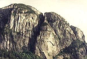
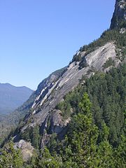
Topography and features
Summits
There are three main summit areas:- First Peak or the South Summit (610 m (2,001 ft))
- Second Peak or the Centre Summit (655 m (2,149 ft))
- Third Peak or the North Summit (702 m (2,303 ft))
Each summit features an expanse of fine glacier-polished
Glacial striations
Glacial striations or glacial grooves are scratches or gouges cut into bedrock by process of glacial abrasion. Glacial striations usually occur as multiple straight, parallel grooves representing the movement of the sediment-loaded base of the glacier...
granite and the promise of incredible views in all directions. Third Peak is a bit more remote and isolated and is less popular with tourists.
An additional summit area lies to the north of all the summits. This area is called the Zodiac Summit. Although it can be considered a sub-summit of Third Peak, it is perhaps the most isolated area of the Chief. No proper trail leads to the Zodiac Summit; there are only faint tracks here and there among the trees.
Hiking trails
All of the three main summits are accessible via the Chief's maintained backside hikingHiking
Hiking is an outdoor activity which consists of walking in natural environments, often in mountainous or other scenic terrain. People often hike on hiking trails. It is such a popular activity that there are numerous hiking organizations worldwide. The health benefits of different types of hiking...
trails. These trails are steep and rugged. In fact, in several high places there are short sections of "trail" that are so steep and/or slippery, that chains and ladders have been bolted to the rock for aid.
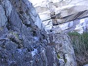
Gullies
The three main summits of the Chief are separated by several deep clefts known as the gullies. These chasms are steep and are partially filled with debris, mostly talus and screeScree
Scree, also called talus, is a term given to an accumulation of broken rock fragments at the base of crags, mountain cliffs, or valley shoulders. Landforms associated with these materials are sometimes called scree slopes or talus piles...
. They were apparently excavated primarily by glacier action.
- South Gully: the Chief's biggest and most noticeable gully, it separates First Peak from Second Peak.
- North Gully: a dark and narrow gully near the north end of the Chief, it separates Second Peak from the "Zodiac Summit".
- North-North Gully: even darker and narrower, this gully separates the "Zodiac Summit" from Third Peak.
There is an additional smaller gully near the south end of the Chief called Bullethead Gully which somewhat separates the Bulletheads region from the rest of the Chief. This gully is very bushy and is much less dramatic than the main gullies mentioned above.
The Apron
Rock faces
The Chief's summits are surrounded by sheer rock wall cliffs. They are typically high, exposed, and surprisingly varied in character. Several of the Chief's more notable rock faces are as follows:- Grand Wall: the centrepiece of the Chief, this steep and pale wall rises over highway 99 just south of the Apron.
- Bulletheads: a region of oddly rounded bulges near the southern end of the Chief.
- Dihedral Wall: this featured expanse of rock is situated between the Grand Wall and Tantalus Wall. In the spring and early summer it is a nesting area for peregrine falconsPeregrine FalconThe Peregrine Falcon , also known as the Peregrine, and historically as the Duck Hawk in North America, is a widespread bird of prey in the family Falconidae. A large, crow-sized falcon, it has a blue-gray back, barred white underparts, and a black head and "moustache"...
. - Tantalus Wall: the sheer face separating the contrasting features of the Dihedral Wall and the Bulletheads. Also a nesting area for peregrine falcons.
- Sheriff's Badge: a white-coloured, star-shaped exfoliationExfoliation (geology)Exfoliation joints or sheet joints are surface-parallel fracture systems in rock often leading to erosion of concentric slabs.- General characteristics of exfoliation joints :* Commonly follow topography ....
scar north-east of the Apron. Sometimes called "the Witch" by local townsfolk. - Zodiac Wall: located at the northernmost end of the Chief, this rock face is dark, isolated, and seldom visited.
The Chief's rock faces, especially the Grand Wall, exhibit the unique textural patterns which result from the process of granitic exfoliation. This is the natural means by which large, high-quality granite formations weather, erode, and age. Rather than crumbling and slowly wearing away, large flakes of granite tend to shear off and drop from the face in layers. On impact with the ground below, the shattered flakes become boulders and talus
Scree
Scree, also called talus, is a term given to an accumulation of broken rock fragments at the base of crags, mountain cliffs, or valley shoulders. Landforms associated with these materials are sometimes called scree slopes or talus piles...
.
Sometimes a flake will partially split away while remaining attached to the rock face. An excellent example of a partially detached flake on the Chief is the renowned Split Pillar on the Grand Wall. The Chief's rock faces are characterized by varied rock features including overhanging roofs, splitter cracks, rock chimneys, dihedrals, ledges, platforms, and lower angle slabs.
The Black Dyke
Basalt
Basalt is a common extrusive volcanic rock. It is usually grey to black and fine-grained due to rapid cooling of lava at the surface of a planet. It may be porphyritic containing larger crystals in a fine matrix, or vesicular, or frothy scoria. Unweathered basalt is black or grey...
and andesite
Andesite
Andesite is an extrusive igneous, volcanic rock, of intermediate composition, with aphanitic to porphyritic texture. In a general sense, it is the intermediate type between basalt and dacite. The mineral assemblage is typically dominated by plagioclase plus pyroxene and/or hornblende. Magnetite,...
magmas, which may have fed volcanoes on the surface above the then-buried granitic rock. These younger magmas cooled quite quickly, which results in a very fine grained, almost glassy texture. The resulting dyke
Dike (geology)
A dike or dyke in geology is a type of sheet intrusion referring to any geologic body that cuts discordantly across* planar wall rock structures, such as bedding or foliation...
is now clearly visible from the Chief's main parking area.
Forest
At the base and around the perimeter of the Chief are thick forests. Although not exactly old growth these stands of trees are representative of pacific coastal temperate rain forestPacific temperate rain forests
The Pacific temperate rain forests ecoregion of North America is the largest temperate rain forest ecoregion on the planet as defined by the World Wildlife Fund...
common in the area. Typical tree species are Douglas Fir, Western Red Cedar, Sitka Spruce
Sitka Spruce
Picea sitchensis, the Sitka Spruce, is a large coniferous evergreen tree growing to 50–70 m tall, exceptionally to 95 m tall, and with a trunk diameter of up to 5 m, exceptionally to 6–7 m diameter...
, and Alder
Alder
Alder is the common name of a genus of flowering plants belonging to the birch family . The genus comprises about 30 species of monoecious trees and shrubs, few reaching large size, distributed throughout the North Temperate Zone and in the Americas along the Andes southwards to...
.
Boulders
Also at the base of the Chief's walls are a bewildering variety of medium-to-large size granite boulderBoulder
In geology, a boulder is a rock with grain size of usually no less than 256 mm diameter. While a boulder may be small enough to move or roll manually, others are extremely massive....
s. Once themselves part of the Chief, these boulders form groups which have been carefully explored by bouldering
Bouldering
Bouldering is a style of rock climbing undertaken without a rope and normally limited to very short climbs over a crash pad so that a fall will not result in serious injury. It is typically practiced on large natural boulders or artificial boulders in gyms and outdoor urban areas...
enthusiasts. Some of the boulders are so large as to seem like small cliffs in their own right. The largest is the Cacodemon Boulder at the base of the Grand Wall, an individual chunk of rock as big as a small apartment building.
Rock climbing
Because of the Chief and several other high-quality climbing areas in the vicinity, Squamish has become a world-class rock climbingRock climbing
Rock climbing also lightly called 'The Gravity Game', is a sport in which participants climb up, down or across natural rock formations or artificial rock walls. The goal is to reach the summit of a formation or the endpoint of a pre-defined route without falling...
destination. Squamish is sometimes referred to as "Yosemite
Yosemite Valley
Yosemite Valley is a glacial valley in Yosemite National Park in the western Sierra Nevada mountains of California, carved out by the Merced River. The valley is about long and up to a mile deep, surrounded by high granite summits such as Half Dome and El Capitan, and densely forested with pines...
North". In terms of structure, composition, and quality of the granitic rock, the Chief reportedly resembles Half Dome
Half Dome
Half Dome is a granite dome in Yosemite National Park, located in northeastern Mariposa County, California, at the eastern end of Yosemite Valley — possibly Yosemite's most familiar rock formation. The granite crest rises more than above the valley floor....
in the Yosemite Valley.
Kevin McLane, longtime rock climber and Squamish guidebook author, describes climbing at the Chief thus: "immense vertical walls, long cool slabs, sinuous dykes
Dike (geology)
A dike or dyke in geology is a type of sheet intrusion referring to any geologic body that cuts discordantly across* planar wall rock structures, such as bedding or foliation...
, and beautiful cracks offer a variety of climbing that is hard to match anywhere." Almost every style of rock climbing at almost every possible skill level can be practiced here, including Traditional climbing
Traditional climbing
Traditional climbing, or trad climbing, is a style of rock climbing in which a climber or group of climbers places all gear required to protect against falls , and removes it when a passage is complete...
, sport climbing
Sport climbing
Sport climbing is a form of rock climbing that relies on permanent anchors fixed to the rock, and possibly bolts, for protection,...
, aid climbing
Aid climbing
Aid climbing is a style of climbing in which standing on or pulling oneself up via devices attached to fixed or placed protection is used to make upward progress....
, and bouldering
Bouldering
Bouldering is a style of rock climbing undertaken without a rope and normally limited to very short climbs over a crash pad so that a fall will not result in serious injury. It is typically practiced on large natural boulders or artificial boulders in gyms and outdoor urban areas...
. Since the Chief is practically at sea-level, the only climbing styles not normally represented are alpine
Alpine climate
Alpine climate is the average weather for a region above the tree line. This climate is also referred to as mountain climate or highland climate....
climbing and ice climbing
Ice climbing
Ice climbing, as the term indicates, is the activity of ascending inclined ice formations. Usually, ice climbing refers to roped and protected climbing of features such as icefalls, frozen waterfalls, and cliffs and rock slabs covered with ice refrozen from flows of water. For the purposes of...
, though ample opportunities exist for these pursuits in the surrounding Coast Mountains.
Rock climber Peter Croft began what continues to be a long and illustrious climbing career in Squamish in the late 1970s. He astounded the climbing community by putting up a number of bold new free climbing
Free climbing
Free climbing is a type of rock climbing in which the climber uses only hands, feet and other parts of the body to ascend, employing ropes and forms of climbing protection to prevent falls only....
routes on the Chief which, at the time, pushed the limits of what people thought was possible. More recently, Brad Zdanivsky became the first quadriplegic ever to reach the summit on 31 July 2005. In the summer of 2006, Sonnie Trotter established what is considered to be the hardest traditionally protected single rock pitch in North America, and possibly the world: Cobra Crack (5.14).