

Longs Peak
Encyclopedia
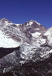
Longs Peak is one of the 53 mountain
s with summits over 14,000 feet
in Colorado
. It can be prominently seen from Longmont
, Colorado
, as well as from the rest of the Colorado Front Range
. It is named after Major Stephen Long
, who explored the area in the 1820s. Longs Peak is one of the most prominent mountains in Colorado, rising 7,000 feet above the town of Estes Park, Colorado
to the northeast.
Together with the nearby Mount Meeker
, the two are sometimes referred to as the Twin Peaks (not to be confused with a nearby lower mountain called Twin Sisters
).
, the peak has long been of interest to climbers
. The easiest route is not "technical" during the summer season. It was probably first used by pre-Columbian
indigenous people
collecting eagle
feathers.
The first recorded ascent was in 1868 by the surveying party of John Wesley Powell
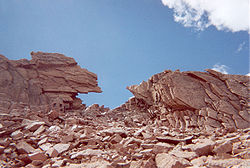
. The East Face of the mountain is quite steep, and is surmounted by a gigantic sheer cliff known as "The Diamond
" (so-named because of its shape, approximately that of a cut diamond
seen from the side and inverted - see image at right). Another famous profile belongs to Longs Peak: to the southeast of the summit is a series of rises which, when viewed from the northeast, resembles a beaver
. The photo shows the beaver climbing the south (left side) of the mountain.
In 1954 the first proposal made to the National Park Service
to climb The Diamond
was met with an official closure, a stance not changed until 1960. The Diamond was first ascended by Dave Rearick
and Bob Kamps
that year, by a route that would come to be known simply as D1
. This route would later be listed in Allen Steck and Steve Roper's influential book Fifty Classic Climbs of North America
. The easiest route on the face is the Casual Route
(5.10a), first climbed in 1977. It has since become the most popular route up the wall.
The oldest person to summit Longs Peak was Rev. William "Col. Billy" Butler, who climbed it on September 2, 1926, his 85th birthday. In 1932, Clerin “Zumie” Zumwalt summited Longs Peak 53 times.
. Most days, no technical climbing is required to reach the summit of Longs Peak during the summer season, which typically runs from mid July through early September. Outside of this window the popular "Keyhole" route is still open, however its rating is upgraded to "technical" as treacherous ice formation and snow fall necessitates the use of specialized climbing equipment including, at a minimum, crampons
and an ice axe
. It is one of the most difficult Class 3
fourteener scrambles in Colorado.
 The hike from the trailhead to the summit is 8 miles (13 km) each way. Most hikers begin before dawn in order to reach the summit and return below the tree line before frequent afternoon thunderstorm
s bring a risk of lightning
strikes. The most difficult portion of the hike begins at the Boulder Field, 6.4 miles (10 km) into the hike. After scrambling over the boulders, hikers reach the Keyhole at 6.7 miles (10.5 km).
The following quarter of a mile involves a scramble along narrow ledges, many of which may have nearly sheer cliffs of 1,000 feet (305 m) or more just off the edge. The next portion of the hike includes climbing over 600 vertical feet (183 m) up the Trough before reaching the most exposed section of the hike, the Narrows. Just beyond the Narrows, the Notch signifies the beginning of the Homestretch, a steep climb to the football field-sized, flat summit. It is possible to camp out overnight in the Boulder Field (permit required) which makes for a less arduous two day hike, although this is fairly exposed to the elements. 57 people have died climbing or hiking Longs Peak. According to the National Park Service, 2 people, on average, die every year attempting to climb the mountain. In the summer of 2005 a Japanese climber was blown off a ledge after reaching the summit. On September 3, 2006 a man fell 800 feet (244 m) to his death when some rocks let go while he was descending the Loft route. Less experienced mountaineers are encouraged to use a guide for this summit to mitigate risk and increase the probability of a summit.
For hikers who do not wish to climb to the summit, there are less-involved hikes on the peak as well. Peacock Pool and Chasm Lake are popular hiking destinations and follow well-maintained trails. It is also rewarding to hike just to the Boulder Field, the Keyhole, or the seldom-visited but spectacular Chasm View. Camping is available at the Boulder Field and also on the lower portions of the mountain, such as Goblin's Forest next to the stream at the bottom. Technical climbers, with the correct permit, are allowed to use "bivy" sites at the base of the East Face and at Chasm View. It is also possible to camp to the south of the mountain at Sand Beach Lake.
 In addition to the standard "Keyhole" route, there are more serious and more technical climbs on Longs Peak. Climbers should seek qualified instruction; deaths on Longs Peak are an annual occurrence. Some of the more common routes are, in approximate order of popularity,
Mountain
Image:Himalaya_annotated.jpg|thumb|right|The Himalayan mountain range with Mount Everestrect 58 14 160 49 Chomo Lonzorect 200 28 335 52 Makalurect 378 24 566 45 Mount Everestrect 188 581 920 656 Tibetan Plateaurect 250 406 340 427 Rong River...
s with summits over 14,000 feet
Fourteener
In mountaineering terminology in the United States, a fourteener is a mountain that exceeds 14,000 feet above mean sea level. There are 547 fourteeners in the world. The importance of fourteeners is greatest in Colorado, which has the majority of such peaks in North America...
in Colorado
Colorado
Colorado is a U.S. state that encompasses much of the Rocky Mountains as well as the northeastern portion of the Colorado Plateau and the western edge of the Great Plains...
. It can be prominently seen from Longmont
Longmont, Colorado
Longmont is a Home Rule Municipality in Boulder and Weld counties in the U.S. state of Colorado. Longmont is located in Northern Colorado. Longmont is the 13th most populous city in the State of Colorado. The word "Longmont" comes from Longs Peak, a prominent mountain named for explorer Stephen H....
, Colorado
Colorado
Colorado is a U.S. state that encompasses much of the Rocky Mountains as well as the northeastern portion of the Colorado Plateau and the western edge of the Great Plains...
, as well as from the rest of the Colorado Front Range
Colorado Front Range
The Colorado Front Range is a colloquial geographic term for the most populous region of the state of Colorado in the United States. The area is located just east of the foothills of the Front Range, aligned in a north-south configuration on the western edge of the Great Plains, where they meet the...
. It is named after Major Stephen Long
Stephen Harriman Long
Stephen Harriman Long was a U.S. army explorer, topographical engineer, and railway engineer. As an inventor, he is noted for his developments in the design of steam locomotives. He was also one of the most prolific explorers of the early 1800s, although his career as an explorer was relatively...
, who explored the area in the 1820s. Longs Peak is one of the most prominent mountains in Colorado, rising 7,000 feet above the town of Estes Park, Colorado
Estes Park, Colorado
Estes Park is a town in Larimer County, Colorado, United States. A popular summer resort and the location of the headquarters for Rocky Mountain National Park, Estes Park lies along the Big Thompson River. Estes Park had a population of 5,858 at the 2010 census...
to the northeast.
Together with the nearby Mount Meeker
Mount Meeker
Mount Meeker is a high mountain peak in northern Colorado, located in the southern part of Rocky Mountain National Park. The elevation is . It is the second highest mountain in Rocky Mountain National Park. The peak is a prominent figure along the northern Front Range of Colorado...
, the two are sometimes referred to as the Twin Peaks (not to be confused with a nearby lower mountain called Twin Sisters
Twin Sisters Peaks
The Twin Sisters Peaks are mountains in Colorado, located in the Front Range in Larimer County, Colorado, straddling Rocky Mountain National Park and Roosevelt National Forest...
).
History of ascents
As the only "fourteener" in Rocky Mountain National ParkRocky Mountain National Park
Rocky Mountain National Park is a national park located in the north-central region of the U.S. state of Colorado.It features majestic mountain views, a variety of wildlife, varied climates and environments—from wooded forests to mountain tundra—and easy access to back-country trails...
, the peak has long been of interest to climbers
Climbing
Climbing is the activity of using one's hands and feet to ascend a steep object. It is done both for recreation and professionally, as part of activities such as maintenance of a structure, or military operations.Climbing activities include:* Bouldering: Ascending boulders or small...
. The easiest route is not "technical" during the summer season. It was probably first used by pre-Columbian
Pre-Columbian era
The pre-Columbian era incorporates all period subdivisions in the history and prehistory of the Americas before the appearance of significant European influences on the American continents, spanning the time of the original settlement in the Upper Paleolithic period to European colonization during...
indigenous people
Native Americans in the United States
Native Americans in the United States are the indigenous peoples in North America within the boundaries of the present-day continental United States, parts of Alaska, and the island state of Hawaii. They are composed of numerous, distinct tribes, states, and ethnic groups, many of which survive as...
collecting eagle
Eagle
Eagles are members of the bird family Accipitridae, and belong to several genera which are not necessarily closely related to each other. Most of the more than 60 species occur in Eurasia and Africa. Outside this area, just two species can be found in the United States and Canada, nine more in...
feathers.
The first recorded ascent was in 1868 by the surveying party of John Wesley Powell
John Wesley Powell
John Wesley Powell was a U.S. soldier, geologist, explorer of the American West, and director of major scientific and cultural institutions...
. The East Face of the mountain is quite steep, and is surmounted by a gigantic sheer cliff known as "The Diamond
The Diamond (Longs Peak)
The Diamond is the sheer and prominent east face of Longs Peak and named for the shape of the cliff. The face has a vertical gain of more than 900 feet all above an elevation of 13,000 feet...
" (so-named because of its shape, approximately that of a cut diamond
Diamond
In mineralogy, diamond is an allotrope of carbon, where the carbon atoms are arranged in a variation of the face-centered cubic crystal structure called a diamond lattice. Diamond is less stable than graphite, but the conversion rate from diamond to graphite is negligible at ambient conditions...
seen from the side and inverted - see image at right). Another famous profile belongs to Longs Peak: to the southeast of the summit is a series of rises which, when viewed from the northeast, resembles a beaver
Beaver
The beaver is a primarily nocturnal, large, semi-aquatic rodent. Castor includes two extant species, North American Beaver and Eurasian Beaver . Beavers are known for building dams, canals, and lodges . They are the second-largest rodent in the world...
. The photo shows the beaver climbing the south (left side) of the mountain.
In 1954 the first proposal made to the National Park Service
National Park Service
The National Park Service is the U.S. federal agency that manages all national parks, many national monuments, and other conservation and historical properties with various title designations...
to climb The Diamond
The Diamond (Longs Peak)
The Diamond is the sheer and prominent east face of Longs Peak and named for the shape of the cliff. The face has a vertical gain of more than 900 feet all above an elevation of 13,000 feet...
was met with an official closure, a stance not changed until 1960. The Diamond was first ascended by Dave Rearick
Dave Rearick
Dave Rearick is an American rock climber and mathematician. A pioneer of Yosemite's golden age of climbing, Rearick - frequently climbing with Bob Kamps – was instrumental in shifting the focus from aid climbing to free climbing in the 1950s....
and Bob Kamps
Bob Kamps
Bob Kamps was an American rock climber whose climbing career spanned five decades. Born in Wisconsin, he began climbing in California in 1955, and was a member of that cadre of Yosemite pioneers who first ascended many of its great walls in the 1950s and 1960s...
that year, by a route that would come to be known simply as D1
D1 (Longs Peak)
The D1 is the original technical climbing route up The Diamond of Longs Peak. In 1954, when National Park Service was petitioned to allow climbing on The Diamond they responded with an official closure. Climbing on The Diamond was banned until 1960...
. This route would later be listed in Allen Steck and Steve Roper's influential book Fifty Classic Climbs of North America
Fifty Classic Climbs of North America
Fifty Classic Climbs Of North America is a climbing guidebook and history written by Steve Roper and Allen Steck. It is considered a definitive piece of climbing literature, known to many climbers as simply "The Book", and has served as an inspiration for more recent climbing books, such as Mark...
. The easiest route on the face is the Casual Route
Casual Route (Longs Peak)
The Casual Route is the easiest technical climbing route up The Diamond of Longs Peak.- External links :****...
(5.10a), first climbed in 1977. It has since become the most popular route up the wall.
The oldest person to summit Longs Peak was Rev. William "Col. Billy" Butler, who climbed it on September 2, 1926, his 85th birthday. In 1932, Clerin “Zumie” Zumwalt summited Longs Peak 53 times.
Mills Glacier
Longs Peak has one glacier named Mills Glacier. The glacier is located around 12,800 feet (3,900 m) at the base of the Eastern Face, just above Chasm Lake. Another permanent snowfield, called The Dove, is located north of Longs Peak. Longs Peak is one of fewer than 50 mountains in Colorado that have a glacier.Hiking Longs Peak
Trails that ascend Longs Peak include the East Longs Peak Trail, the Longs Peak Trail, the Keyhole Route, Clark's Arrow and the Shelf TrailEast Longs Peak Trail-Longs Peak Trail-Keyhole Route-Shelf Trail
The East Longs Peak Trail, Longs Peak Trail and Keyhole Route-Shelf Trail in Rocky Mountain National Park are listed on the National Register of Historic Places for their significance in the early recreational development of the park. The East Longs Peak Trail was laid out in 1878 by Reverend...
. Most days, no technical climbing is required to reach the summit of Longs Peak during the summer season, which typically runs from mid July through early September. Outside of this window the popular "Keyhole" route is still open, however its rating is upgraded to "technical" as treacherous ice formation and snow fall necessitates the use of specialized climbing equipment including, at a minimum, crampons
Crampons
Crampons are traction devices used to improve mobility on snow and ice. There are three main attachment systems for footwear: step-in, hybrid, and strap bindings. The first two require boots with welts, the last adapt to any type....
and an ice axe
Ice axe
An ice axe, is a multi-purpose ice and snow tool used by mountaineers both in the ascent and descent of routes which involve frozen conditions. It can be held and employed in a number of different ways, depending on the terrain encountered...
. It is one of the most difficult Class 3
Yosemite Decimal System
The Yosemite Decimal System is a three-part system used for rating the difficulty of walks, hikes, and climbs. It is primarily used by mountaineers in the United States and Canada. The Class 5 portion of the Class scale is primarily a rock climbing classification system. Originally the system was...
fourteener scrambles in Colorado.
Thunderstorm
A thunderstorm, also known as an electrical storm, a lightning storm, thundershower or simply a storm is a form of weather characterized by the presence of lightning and its acoustic effect on the Earth's atmosphere known as thunder. The meteorologically assigned cloud type associated with the...
s bring a risk of lightning
Lightning
Lightning is an atmospheric electrostatic discharge accompanied by thunder, which typically occurs during thunderstorms, and sometimes during volcanic eruptions or dust storms...
strikes. The most difficult portion of the hike begins at the Boulder Field, 6.4 miles (10 km) into the hike. After scrambling over the boulders, hikers reach the Keyhole at 6.7 miles (10.5 km).
The following quarter of a mile involves a scramble along narrow ledges, many of which may have nearly sheer cliffs of 1,000 feet (305 m) or more just off the edge. The next portion of the hike includes climbing over 600 vertical feet (183 m) up the Trough before reaching the most exposed section of the hike, the Narrows. Just beyond the Narrows, the Notch signifies the beginning of the Homestretch, a steep climb to the football field-sized, flat summit. It is possible to camp out overnight in the Boulder Field (permit required) which makes for a less arduous two day hike, although this is fairly exposed to the elements. 57 people have died climbing or hiking Longs Peak. According to the National Park Service, 2 people, on average, die every year attempting to climb the mountain. In the summer of 2005 a Japanese climber was blown off a ledge after reaching the summit. On September 3, 2006 a man fell 800 feet (244 m) to his death when some rocks let go while he was descending the Loft route. Less experienced mountaineers are encouraged to use a guide for this summit to mitigate risk and increase the probability of a summit.
For hikers who do not wish to climb to the summit, there are less-involved hikes on the peak as well. Peacock Pool and Chasm Lake are popular hiking destinations and follow well-maintained trails. It is also rewarding to hike just to the Boulder Field, the Keyhole, or the seldom-visited but spectacular Chasm View. Camping is available at the Boulder Field and also on the lower portions of the mountain, such as Goblin's Forest next to the stream at the bottom. Technical climbers, with the correct permit, are allowed to use "bivy" sites at the base of the East Face and at Chasm View. It is also possible to camp to the south of the mountain at Sand Beach Lake.
Climbing Longs Peak
- North Face Cables route. This follows the Keyhole route to the Boulder Field, then ascends the North Face of the peak. It requires one or two pitches of low-5th class climbing, and is often downclimbed or rappelled by technical climbers since it is one of the fastest ways to ascend or descend the peak. In the early 20th century, enterprising guides installed a series of large steel eye bolts along this route, connecting them with a steel cable similar to systems in the AlpsAlpsThe Alps is one of the great mountain range systems of Europe, stretching from Austria and Slovenia in the east through Italy, Switzerland, Liechtenstein and Germany to France in the west....
. The cables were removed in 1973 due to the lightning hazard, but the bolts remain and are used as rappel anchors. - Kieners Route. A traditional mountaineering climb that involves a climb of Lambs Slide, which is icy later in the season, then an exposed traverse of the Broadway ledge, and then low-5th class climbing. Lambs Slide is so-named because of the Reverend Elkanah J. Lamb's nearly fatal tumble down it http://earthboundsports.com/RMNP-History.pdf. The most recent fatal tumble was November, 2006.
- via the Loft. The Loft is the semi-permanent snowfield between Longs Peak and its south-eastern neighbor Mt. Meeker. From the saddle you can traverse to either peak. One such traverse route is Gorilla's Traverse. It is also possible to ascend to the saddle via Lambs Slide.
- via the East Face. The East Face is the steep, 1,000 + foot (305 + m) wall that includes the Diamond and the Lower East Face. All climbs here are technical, from 5.10 to 5.13. It is also possible to ascend to the (climber's) left of the Diamond face proper. The routes on the right side of the Diamond are often aid climbedAid climbingAid climbing is a style of climbing in which standing on or pulling oneself up via devices attached to fixed or placed protection is used to make upward progress....
, and may require spending the night on the wall; the rock here can be very wet. Routes on the left side of the Diamond are usually free climbedFree climbingFree climbing is a type of rock climbing in which the climber uses only hands, feet and other parts of the body to ascend, employing ropes and forms of climbing protection to prevent falls only....
. Only qualified climbers should attempt climbs on this face, and should take into consideration the effects of altitude and alpine conditions in addition to the difficulty ratingYosemite Decimal SystemThe Yosemite Decimal System is a three-part system used for rating the difficulty of walks, hikes, and climbs. It is primarily used by mountaineers in the United States and Canada. The Class 5 portion of the Class scale is primarily a rock climbing classification system. Originally the system was...
. - via the Notch Couloir. This is a technical climb involving rock climbing and, at some times of year, ice climbingIce climbingIce climbing, as the term indicates, is the activity of ascending inclined ice formations. Usually, ice climbing refers to roped and protected climbing of features such as icefalls, frozen waterfalls, and cliffs and rock slabs covered with ice refrozen from flows of water. For the purposes of...
. The Notch Couloir is to the (climber's) left of the Diamond face.
See also
- List of Colorado fourteeners
- Mountain peaks of ColoradoMountain peaks of ColoradoThis article comprises three sortable tables of the major mountain peaks of the U.S. State of Colorado.Topographic elevation is the vertical distance above the reference geoid, a precise mathematical model of the Earth's sea level as an equipotential gravitational surface...
- Mountain ranges of ColoradoMountain ranges of ColoradoThe following table lists the major mountain ranges of the U.S. State of Colorado.-Mountain Ranges:-See also:*4000 meter peaks of Colorado*Colorado mountain passes*Geography of Colorado*Lists of mountains*Mountain peaks of Colorado...
External links
-
-
- Longs Peak on 14ers.com
- Longs Peak Keyhole Route on 14ers.com
- Longs Peak on Distantpeak.com
- Longs Peak on Bivouac.com
- Longs Peak hiking info
- Longs Peak on Mountain Project
- Longs Peak via the Boulder Field
- National Park Service guide to climbing Longs Peak
- Longs Peak Journal and Trip Report
- History of Longs Peak
- Steck and Roper's 50 Classic Climbs
- VIDEO Climbing Longs Peak - DailyCamera.com