
Gran Canaria
Encyclopedia
Gran Canaria is the second most populous island of the Canary Islands
, with a population of 838,397 which constitutes approximately 40% of the population of the archipelago. Located in the Atlantic Ocean
about 150 kilometers (~93 miles) off the northwestern coast of Africa
and about 1350 km (~838 miles) from Europe
.
The capital of the island, Las Palmas de Gran Canaria
, is also the largest city and the capital of the autonomous community
of the Canary Islands.
, who may have arrived as early as 500 BC. The Canarii called the island Tamarán or Land of the Brave. After over a century of European (French, Portuguese...) incursions and attempts at conquest, the island was conquered on April 29, 1483, after a campaign that lasted 5 years, by the Kingdom of Castile
, with the support of Queen Isabella I
, a conquest which turned out to be an important step towards the expansion of the unified Spain
.
The capital city of Las Palmas de Gran Canaria
was founded on June 24, 1478, under the name "Real de Las Palmas", by Juan Rejón
, head of the invading Castilian
army. In 1492, Christopher Columbus
anchored in the Port of Las Palmas (and spent some time on the island) on his first trip to the Americas.
 Gran Canaria is located southeast of Tenerife
and west of Fuerteventura
. The island is of volcanic
origin, mostly made of fissure vent
s. Gran Canaria's surface area is 1,560 km² and its maximum altitude is 1,949 meters (Pico de Las Nieves
). It has a round shape, with a diameter of approximately 50 km.
period, between 14 and 9 million years ago. This is called the "Old Cycle" and is estimated to have lasted some 200,000 years and have emitted about 1000 km3, mostly of fissural alkali basalt
. This cycle continued with the emission of trachyte
s, phonolite
s and peralkaline
rocks. This period was followed by one of erosion, which lasted some 4 million years.
A second cycle of volcanic eruptions, known as the "Roque Nublo cycle", took place between 4.5 and 3.4 million years ago. This shorter cycle emitted about 100 km3. Most of the inland peaks were formed by erosion from these materials. This period also started with fissural basalts, but ended with violent eruptions of pyroclastic flows. Some phonolitic features, like the Risco Blanco, were also formed in its last stages.
The third or recent cycle is held to have started some 2.8 million years ago and is considered to be still active. The last eruptions are held to have occurred some 3500 years ago.
The changes in volume and, therefore, weight of the island have also caused the island to rise above the previous sea level during erosive periods and to sink during eruptive periods. Some of these "fossil beaches" can be seen in the cliff faces of the more eroded northern coast.
The island has a population of 845,676 with 378,628 (year 2005) of those in the capital city of Las Palmas de Gran Canaria
. Gran Canaria is the second most populous island of the Canary Islands. Las Palmas de Gran Canaria
is the capital of the province of Las Palmas, and also one of the two capitals of the autonomous community
of the Canary Islands
, along with Santa Cruz de Tenerife
.
, GC2
, and GC31, and dual carriageway
s GC4 and GC5. The western and the northwestern parts, with the fewest inhabitants, are linked only with main roads.
Gran Canaria Airport (IATA: LPA) is the only commercial airport on the island. The large number of aircraft and passengers passing through it each year make it one of the busiest in Spain. Gran Canaria also hosts the responsibility of controlling all air traffic of the Canaries.
The most important ports in the island are the Port of Las Palmas
, in the city of Las Palmas de Gran Canaria
; Arguineguín, which exports cement from a large factory; and Arinaga, located in the major industrial zone of Canaries and one of the major ones of Spain. The ports which transport the most passengers are the Port of La Luz and the Port of Las Nieves, placed in the municipality of Agaete
.
Plans for a railway network linking the capital with the south have been approved by both the Gran Canaria Cabildo and the Canary Islands Government, though the discussion with the central Spanish Government hinges now on budget.
. Generally speaking though,
the average daytime high ranges from 20°C in winter, to 26°C in summer. Some cool nights occur in winter, but lows below 10°C are unknown near the coast. Inland the climate is still mild but mountainous areas see the occasional frost or snow. Annual rainfall averages 228 mm, most of this falling in the cooler months, with July, August and September normally rainless. Rainfall is unevenly distributed through the island with some areas being much drier than others.
Cloud cover and sunshine is often quite variable during the cooler months, and there can be several rather cloudy days at times in winter. Summers are generally quite sunny however, with the south of the island being most favoured.
by UNESCO
.
The number of annual visitors is 2.2 million (2,200,000). Most of the tourists visit the southern part of the island.
The north tends to be cooler while the south is warmer and sunny. The east coast of the island is flat dotted with beaches while the western coast is rockier and mountainous.
The island possesses 32 Natural Protected Spaces, that they emphasize the Rural Park of Nublo, The Doramas Jungle, the Azuaje Ravine, Tamadaba, Pino Santo, etc.
Most tourists stay in the south of the island, which is sunnier and has less rain than the north. In the south there is a large bird park, Palmitos Park
, as well as many beach resort communities. Resorts are concentrated in the central eastern part of the southern coast in the Maspalomas area, which includes the towns of San Agustín
, Playa del Inglés
, Sonnenland
, Maspalomas
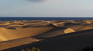
and Meloneras. The Dunes of Maspalomas are located between Playa del Inglés ("The Englishman's Beach") and Maspalomas. Another tourist attraction is the lighthouse at Maspalomas situated at the western end of Maspalomas.
In Tarajalillo, an Aeroclub exists from where tourist flights can be taken over the island.
Still further to the west along the southern shore, in the Municipality of Mogán, are the communities of Puerto Rico and Puerto de Mogán
, a village referred to as "Little Venice" on account of its many canals.
Other attractions include Cocodrilos Park, Roque Nublo
(an 80 m monolith), Cenobio de Valerón with about 290 caves, Cueva Pintada the most important archaeological park in Canary Islands and the botanical gardens Jardin Canario (in Tafira Alta) and Cactualdea (in La Aldea de San Nicolás).
El Dedo de Dios
, or "God's Finger" was a rocky spire jutting from the sea in Puerto de las Nieves, and was previously the signature attraction of the Canary Islands until it was destroyed by Tropical Storm Delta
, that crossed the archipelago on November 2005.
Other well-known rock formations are El Cura (also known as El Fraile), The Frog (La Rana), Bentayga, the Roque de Gando, and the Peñón Bermejo. The highest peak of the island is the Pico de las Nieves, at 1950 metres (6,397.6 ft).
The capital city is Las Palmas de Gran Canaria
. Las Canteras Beach lies in the heart of the city, (www.miplayadelascanteras.com) protected area and diving zone. Las Palmas de Gran Canaria is also known for its annual Carnaval
. It was the first stop of Christopher Columbus' expedition on his way back from the Americas, a commemoration of which is the Hermitage of San Antonio Abad, where the navigator prayed, and the Casa de Colón. Other attractions in the capital city include the Museo Canario (the most important archaeology museum in the archipelago), the Cathedral and the Plaza del Espíritu Santo. In Teror
the shrine of Virgen del Pino
, patron saint of Gran Canaria, can be found.
The town of Agüimes, on the eastern part of the island, has been carefully restored, and its town centre, centered around its old church and a peaceful square, now evokes the quiet living of a traditional Canarian town. The district also has some of the best preserved cave dwellings, in the protected area of the Guayadeque Ravine, where even the church has been built into the hillside and visitors can find a number of popular cave restaurants. The district also includes the most renowned scuba diving area on the island: the marine reserve at the playa de El Cabrón just outside the town of Arinaga.
Other important towns are Telde and Vecindario (within the municipality of Santa Lucía de Tirajana) and Gáldar important diving zone. In Arucas there is a Neogothic temple, popularly known as "Arucas' Cathedral", as well as a large fertile plain where bananas are grown. In Gáldar and its surroundings there is also a banana-growing plain and some remarkable archaeological remains, such as Cueva Pintada or Cenobio de Valerón's communal silos, ancient tombs, and the port of Sardina del Norte (one of the island's ports where, as in Las Palmas', Christopher Columbus
used to get supplies for his ships).
Heading west along the southern coast is the fishing city of Arguineguín
in the Municipality of Mogán
.
 Nearly half of the island territory - 667 km² (42,7% of island), is under protection from the Red Canaria de Espacios Naturales Protegidos (Canary Islands Network for Naturally Protected Areas). Of the 146 protected sites under control of network in the Canary Islands archipelago, a total of 33 are located in Gran Canaria, the second most protected island in the group.
There are seven different categories of protection: six nature reserve
s: El Brezal, Azuaje, Los Tilos de Moya, Los Marteles, Las Dunas de Maspalomas and Güigüi (total 7,153.1 ha); two integral nature reserves: Inagua and Barranco Oscuro (total 3,955,5 ha); two natural parks: Tamadaba and Pilancones (total 13,333 ha), two rural parks: Nublo and Doramas (total 29,893.4 ha), ten natural monument
s: Amagro, Bandama, Montañón Negro, Roque de Aguayro, Tauro, Arinaga, Barranco de Guayadeque, Riscos de Tirajana, Roque Nublo and Barranco del Draguillo (total 5,264.9 ha), seven protected landscapes: La Isleta (in the capital Las Palmas), Pino Santo, Tafira, Las Cumbres, Lomo Magullo, Fataga and Montaña de Agüimes (total 12,680.9 ha); four sites of scientific interest
: Jinámar, Tufia, Roque de Gando and Juncalillo del Sur (total 276.2 ha).
Canary Islands
The Canary Islands , also known as the Canaries , is a Spanish archipelago located just off the northwest coast of mainland Africa, 100 km west of the border between Morocco and the Western Sahara. The Canaries are a Spanish autonomous community and an outermost region of the European Union...
, with a population of 838,397 which constitutes approximately 40% of the population of the archipelago. Located in the Atlantic Ocean
Atlantic Ocean
The Atlantic Ocean is the second-largest of the world's oceanic divisions. With a total area of about , it covers approximately 20% of the Earth's surface and about 26% of its water surface area...
about 150 kilometers (~93 miles) off the northwestern coast of Africa
Africa
Africa is the world's second largest and second most populous continent, after Asia. At about 30.2 million km² including adjacent islands, it covers 6% of the Earth's total surface area and 20.4% of the total land area...
and about 1350 km (~838 miles) from Europe
Europe
Europe is, by convention, one of the world's seven continents. Comprising the westernmost peninsula of Eurasia, Europe is generally 'divided' from Asia to its east by the watershed divides of the Ural and Caucasus Mountains, the Ural River, the Caspian and Black Seas, and the waterways connecting...
.
The capital of the island, Las Palmas de Gran Canaria
Las Palmas de Gran Canaria
Las Palmas de Gran Canaria commonly known as Las Palmas is the political capital, jointly with Santa Cruz, the most populous city in the Autonomous Community of the Canary Islands and the ninth largest city in Spain, with a population of 383,308 in 2010. Nearly half of the people of the island...
, is also the largest city and the capital of the autonomous community
Autonomous communities of Spain
An autonomous community In other languages of Spain:*Catalan/Valencian .*Galician .*Basque . The second article of the constitution recognizes the rights of "nationalities and regions" to self-government and declares the "indissoluble unity of the Spanish nation".Political power in Spain is...
of the Canary Islands.
History
Gran Canaria was populated by the Canarii (Guanches)Guanches
Guanches is the name given to the aboriginal Berber inhabitants of the Canary Islands. It is believed that they migrated to the archipelago sometime between 1000 BCE and 100 BCE or perhaps earlier...
, who may have arrived as early as 500 BC. The Canarii called the island Tamarán or Land of the Brave. After over a century of European (French, Portuguese...) incursions and attempts at conquest, the island was conquered on April 29, 1483, after a campaign that lasted 5 years, by the Kingdom of Castile
Kingdom of Castile
Kingdom of Castile was one of the medieval kingdoms of the Iberian Peninsula. It emerged as a political autonomous entity in the 9th century. It was called County of Castile and was held in vassalage from the Kingdom of León. Its name comes from the host of castles constructed in the region...
, with the support of Queen Isabella I
Isabella I of Castile
Isabella I was Queen of Castile and León. She and her husband Ferdinand II of Aragon brought stability to both kingdoms that became the basis for the unification of Spain. Later the two laid the foundations for the political unification of Spain under their grandson, Charles V, Holy Roman Emperor...
, a conquest which turned out to be an important step towards the expansion of the unified Spain
Spain
Spain , officially the Kingdom of Spain languages]] under the European Charter for Regional or Minority Languages. In each of these, Spain's official name is as follows:;;;;;;), is a country and member state of the European Union located in southwestern Europe on the Iberian Peninsula...
.
The capital city of Las Palmas de Gran Canaria
Las Palmas de Gran Canaria
Las Palmas de Gran Canaria commonly known as Las Palmas is the political capital, jointly with Santa Cruz, the most populous city in the Autonomous Community of the Canary Islands and the ninth largest city in Spain, with a population of 383,308 in 2010. Nearly half of the people of the island...
was founded on June 24, 1478, under the name "Real de Las Palmas", by Juan Rejón
Juan Rejón
Juan Rejón was an Aragonese captain in the service of the Castilian navy, who was appointed by the Catholic Monarchs to participate in the conquest of the Canary Islands. Rejón founded the city of Las Palmas de Gran Canaria....
, head of the invading Castilian
Kingdom of Castile
Kingdom of Castile was one of the medieval kingdoms of the Iberian Peninsula. It emerged as a political autonomous entity in the 9th century. It was called County of Castile and was held in vassalage from the Kingdom of León. Its name comes from the host of castles constructed in the region...
army. In 1492, Christopher Columbus
Christopher Columbus
Christopher Columbus was an explorer, colonizer, and navigator, born in the Republic of Genoa, in northwestern Italy. Under the auspices of the Catholic Monarchs of Spain, he completed four voyages across the Atlantic Ocean that led to general European awareness of the American continents in the...
anchored in the Port of Las Palmas (and spent some time on the island) on his first trip to the Americas.
Geography
Tenerife
Tenerife is the largest and most populous island of the seven Canary Islands, it is also the most populated island of Spain, with a land area of 2,034.38 km² and 906,854 inhabitants, 43% of the total population of the Canary Islands. About five million tourists visit Tenerife each year, the...
and west of Fuerteventura
Fuerteventura
Fuerteventura , a Spanish island, is one of the Canary Islands, in the Atlantic Ocean off the coast of Africa. It is situated at 28°20' north, 14°00' west. At 1,660 km² it is the second largest of the Canary Islands, after Tenerife...
. The island is of volcanic
Volcano
2. Bedrock3. Conduit 4. Base5. Sill6. Dike7. Layers of ash emitted by the volcano8. Flank| 9. Layers of lava emitted by the volcano10. Throat11. Parasitic cone12. Lava flow13. Vent14. Crater15...
origin, mostly made of fissure vent
Fissure vent
A fissure vent, also known as a volcanic fissure or simply fissure, is a linear volcanic vent through which lava erupts, usually without any explosive activity. The vent is usually a few meters wide and may be many kilometers long. Fissure vents can cause large flood basalts and lava channels...
s. Gran Canaria's surface area is 1,560 km² and its maximum altitude is 1,949 meters (Pico de Las Nieves
Pico de Las Nieves
Pico de Las Nieves is the highest peak of the island of Gran Canaria, Canary Islands, Spain. Its height is 1,949 meters above sea level. The origin is volcanic...
). It has a round shape, with a diameter of approximately 50 km.
Geology
About 80% of the volume of the island was formed during the MioceneMiocene
The Miocene is a geological epoch of the Neogene Period and extends from about . The Miocene was named by Sir Charles Lyell. Its name comes from the Greek words and and means "less recent" because it has 18% fewer modern sea invertebrates than the Pliocene. The Miocene follows the Oligocene...
period, between 14 and 9 million years ago. This is called the "Old Cycle" and is estimated to have lasted some 200,000 years and have emitted about 1000 km3, mostly of fissural alkali basalt
Alkali basalt
Alkali basalt is a fine-grained, dark-coloured, volcanic rock characterized by phenocrysts of olivine, titanium-rich augite, plagioclase feldspar and iron oxides. For similar SiO2 concentrations, alkali basalts have a higher content of the alkalis, Na2O and K2O, than other basalt types such as...
. This cycle continued with the emission of trachyte
Trachyte
Trachyte is an igneous volcanic rock with an aphanitic to porphyritic texture. The mineral assemblage consists of essential alkali feldspar; relatively minor plagioclase and quartz or a feldspathoid such as nepheline may also be present....
s, phonolite
Phonolite
Phonolite is a rare igneous, volcanic rock of intermediate composition, with aphanitic to porphyritic texture....
s and peralkaline
Peralkaline
Peralkaline rocks include those igneous rocks which have a deficiency of aluminium such that sodium and potassium are in excess of that needed for feldspar. The presence of aegerine and riebeckite are indicative of peralkaline conditions....
rocks. This period was followed by one of erosion, which lasted some 4 million years.
A second cycle of volcanic eruptions, known as the "Roque Nublo cycle", took place between 4.5 and 3.4 million years ago. This shorter cycle emitted about 100 km3. Most of the inland peaks were formed by erosion from these materials. This period also started with fissural basalts, but ended with violent eruptions of pyroclastic flows. Some phonolitic features, like the Risco Blanco, were also formed in its last stages.
The third or recent cycle is held to have started some 2.8 million years ago and is considered to be still active. The last eruptions are held to have occurred some 3500 years ago.
The changes in volume and, therefore, weight of the island have also caused the island to rise above the previous sea level during erosive periods and to sink during eruptive periods. Some of these "fossil beaches" can be seen in the cliff faces of the more eroded northern coast.
Municipalities
Gran Canaria is divided into twenty-one municipalities:- Agaete
- AgüimesAgüimes, Las PalmasAgüimes is a Canarian municipality in the eastern portion of the island of Gran Canaria in the Las Palmas province in the Canary Islands. The population is 23,572 , its density is 297.33/km² and the area is 79.28 km². The elevation is 275 m. Agüimes is situated between the mountains and the...
- ArtenaraArtenara, Las PalmasArtenara is a Canarian municipality in the west/central and the central portion of the island of Gran Canaria in the Las Palmas province in the Canary Islands. The population is 1,357 , its density is 20.34/km² and the area is 66.7 km²...
- ArucasArucas, Las PalmasArucas is a Canary Islands municipality in the province of Las Palmas. It is situated in the north of Gran Canaria. Arucas is a suburb of Las Palmas city....
- FirgasFirgas, Las PalmasFirgas is a Canary Islands municipality in the province of Las Palmas. Is a suburb of Las Palmas city. It is situated in the north of Gran Canaria. It has an area of 15.77 km², 7,023 inhabitants and the density of 455.34/km². It celebrated its 500th anniversary in 1988...
- GáldarGáldar, Las PalmasGáldar's area is 61.59 km² with a population of about 22,763 and its density is 369.59/km².Gáldar is situated in the mountains and are surrounded by valleys. Farmlands are within the coastline while the mountains lies to the southeast, the Atlantic Ocean lies to the west and to the north. A...
- IngenioIngenio, Las PalmasIngenio is a Canarian municipality in the eastern portion of the island of Gran Canaria in the Las Palmas province in the Canary Islands. The population is 26,857 , its density is 692.87/km² and the area is 38.15 km²....
- Las Palmas de Gran CanariaLas Palmas de Gran CanariaLas Palmas de Gran Canaria commonly known as Las Palmas is the political capital, jointly with Santa Cruz, the most populous city in the Autonomous Community of the Canary Islands and the ninth largest city in Spain, with a population of 383,308 in 2010. Nearly half of the people of the island...
- MogánMogán, Las PalmasMogán is a municipality in the southwestern corner of the island of Gran Canaria, which is one of the three main islands making up the Spanish province of Las Palmas in the Canary Islands. It includes the fishing towns of Puerto de Mogán and Arguineguin. Mogán is the second largest municipality by...
- MoyaMoya, Las PalmasMoya is a municipality of Las Palmas province, on the Canary Islands. It is in the northern part of the Grand Canary island or Gran Canaria.Moya's area is 31.87 km² with a population of about 8,307 and its density is 250.63/km²....
- San Bartolomé de TirajanaSan Bartolomé de TirajanaSan Bartolomé de Tirajana is a Canarian municipality in the southeastern portion of the island of Gran Canaria in the Las Palmas province in the Canary Islands...
- San Nicolás de TolentinoLa Aldea de San NicolásLa Aldea de San Nicolás or San Nicolás de Tolentino is a Canarian municipality in the western portion of the island of Gran Canaria in the Las Palmas province in the Canary Islands and is the westernmost municipality in the province...
- Sta. BrígidaSanta Brígida, Las PalmasVilla de Santa Brígida is a Canarian municipality in the northeastern portion of the island of Gran Canaria in the Province of Las Palmas of the Canary Islands. The suburbs of Las Palmas. The population is 18,817 , its density is 790.3/km² and the area is 23.81 km²...
- Sta. Lucía de TirajanaSanta Lucía de TirajanaSanta Lucía de Tirajana is a Canarian municipality in the southeastern portion of the island of Gran Canaria in the Las Palmas province in the Canary Islands. The population is 53,820 , its density is 882.58/km² and the area is 61.56 km²...
- Santa María de GuíaSanta María de Guía de Gran CanariaSanta María de Guía de Gran Canaria is a municipality in Las Palmas province of the Canary Islands. It is located on the north side of Grand Canary island....
- Tejeda
- TeldeTelde, Las PalmasTelde is a municipality in the eastern on the island of Gran Canaria, Canary Islands, Spain. The suburb of Las Palmas city. It is the second most populated municipality on the island, with a population of 100,015...
- Teror
- VallesecoValleseco, Las PalmasValleseco is a municipality of Las Palmas province, on the Canary Islands. It is in the northcentral part of Gran Canaria. Valleseco means "dry valley" in Spanish, but its name is misleading, since it is actually one of the wettest municipalities of the island....
- ValsequilloValsequillo de Gran CanariaValsequillo de Gran Canaria is a Canarian municipality in the eastern portion of the island of Gran Canaria in the Las Palmas province in the Canary Islands. The population is 8,381 , its density is 214.07/km² and the area is 39.15 km². Valsequillo is situated in a mountain setting...
- Vega de San MateoVega de San Mateo, Las PalmasVega de San Mateo Vega de San Mateo Vega de San Mateo (latter part Spanish meaning Saint Matthew is a Canarian municipality in the eastern portion of the island of Gran Canaria in the Las Palmas province in the Canary Islands. The population is 7,617 , its density is 199.66/km² and the area...
The island has a population of 845,676 with 378,628 (year 2005) of those in the capital city of Las Palmas de Gran Canaria
Las Palmas de Gran Canaria
Las Palmas de Gran Canaria commonly known as Las Palmas is the political capital, jointly with Santa Cruz, the most populous city in the Autonomous Community of the Canary Islands and the ninth largest city in Spain, with a population of 383,308 in 2010. Nearly half of the people of the island...
. Gran Canaria is the second most populous island of the Canary Islands. Las Palmas de Gran Canaria
Las Palmas de Gran Canaria
Las Palmas de Gran Canaria commonly known as Las Palmas is the political capital, jointly with Santa Cruz, the most populous city in the Autonomous Community of the Canary Islands and the ninth largest city in Spain, with a population of 383,308 in 2010. Nearly half of the people of the island...
is the capital of the province of Las Palmas, and also one of the two capitals of the autonomous community
Autonomous communities of Spain
An autonomous community In other languages of Spain:*Catalan/Valencian .*Galician .*Basque . The second article of the constitution recognizes the rights of "nationalities and regions" to self-government and declares the "indissoluble unity of the Spanish nation".Political power in Spain is...
of the Canary Islands
Canary Islands
The Canary Islands , also known as the Canaries , is a Spanish archipelago located just off the northwest coast of mainland Africa, 100 km west of the border between Morocco and the Western Sahara. The Canaries are a Spanish autonomous community and an outermost region of the European Union...
, along with Santa Cruz de Tenerife
Santa Cruz de Tenerife
Santa Cruz de Tenerife is the capital , second-most populous city of the Autonomous Community of the Canary Islands and the 21st largest city in Spain, with a population of 222,417 in 2009...
.
Transportation
Gran Canaria has roads encircling the whole island and extending into the mountain areas. In the late 20th century, its motorways, among the first in the Canary Islands, were opened and ran around Las Palmas, and were later extended to the north coast and the airport and subsequently to the south coast to account for increased tourist traffic. The high-speed motorways are GC1GC1 (Gran Canaria)
The GC1 is a superhighway on the island of Gran Canaria. It links the capital Las Palmas in the north with Puerto Rico in the south. It is the fastest route from the top of the island to the bottom and vice versa with a top speed limit of 120 km/h...
, GC2
GC2 (Gran Canaria)
The GC-2 North Highway in Gran Canaria . Connects Las Palmas de Gran Canaria with the north little port and village of Agaete...
, and GC31, and dual carriageway
Dual carriageway
A dual carriageway is a class of highway with two carriageways for traffic travelling in opposite directions separated by a central reservation...
s GC4 and GC5. The western and the northwestern parts, with the fewest inhabitants, are linked only with main roads.
Gran Canaria Airport (IATA: LPA) is the only commercial airport on the island. The large number of aircraft and passengers passing through it each year make it one of the busiest in Spain. Gran Canaria also hosts the responsibility of controlling all air traffic of the Canaries.
The most important ports in the island are the Port of Las Palmas
Port of Las Palmas
Port of Las Palmas is a port for fishing, commercial, passenger and sports boats in the north-west of the Las Palmas, Spain, European Union. For five centuries, the Port of Las Palmas has been the traditional base for scale and supplying ships on their way through the Middle Atlantic...
, in the city of Las Palmas de Gran Canaria
Las Palmas de Gran Canaria
Las Palmas de Gran Canaria commonly known as Las Palmas is the political capital, jointly with Santa Cruz, the most populous city in the Autonomous Community of the Canary Islands and the ninth largest city in Spain, with a population of 383,308 in 2010. Nearly half of the people of the island...
; Arguineguín, which exports cement from a large factory; and Arinaga, located in the major industrial zone of Canaries and one of the major ones of Spain. The ports which transport the most passengers are the Port of La Luz and the Port of Las Nieves, placed in the municipality of Agaete
Agaete
Agaete is a municipality of Las Palmas province, on the Canary Islands, Spain. It is in the northwest of Gran Canaria island, enclosed by the Atlantic Ocean to the west, Gáldar to the northeast, and Artenara to the south...
.
Plans for a railway network linking the capital with the south have been approved by both the Gran Canaria Cabildo and the Canary Islands Government, though the discussion with the central Spanish Government hinges now on budget.
Climate
Gran Canaria is noted for its rich variety of micro climatesMicroclimate
A microclimate is a local atmospheric zone where the climate differs from the surrounding area. The term may refer to areas as small as a few square feet or as large as many square miles...
. Generally speaking though,
the average daytime high ranges from 20°C in winter, to 26°C in summer. Some cool nights occur in winter, but lows below 10°C are unknown near the coast. Inland the climate is still mild but mountainous areas see the occasional frost or snow. Annual rainfall averages 228 mm, most of this falling in the cooler months, with July, August and September normally rainless. Rainfall is unevenly distributed through the island with some areas being much drier than others.
Cloud cover and sunshine is often quite variable during the cooler months, and there can be several rather cloudy days at times in winter. Summers are generally quite sunny however, with the south of the island being most favoured.
Tourism
This island is called a "Miniature Continent" due to the different climates and variety of landscapes found, with long beaches and dunes of white sand, contrasting with green ravines and picturesque villages. A third of the island is under protection as a Biosphere ReserveBiosphere reserve
The Man and the Biosphere Programme of UNESCO was established in 1971 to promote interdisciplinary approaches to management, research and education in ecosystem conservation and sustainable use of natural resources.-Development:...
by UNESCO
UNESCO
The United Nations Educational, Scientific and Cultural Organization is a specialized agency of the United Nations...
.
The number of annual visitors is 2.2 million (2,200,000). Most of the tourists visit the southern part of the island.
The north tends to be cooler while the south is warmer and sunny. The east coast of the island is flat dotted with beaches while the western coast is rockier and mountainous.
The island possesses 32 Natural Protected Spaces, that they emphasize the Rural Park of Nublo, The Doramas Jungle, the Azuaje Ravine, Tamadaba, Pino Santo, etc.
Most tourists stay in the south of the island, which is sunnier and has less rain than the north. In the south there is a large bird park, Palmitos Park
Palmitos Park
Palmitos Park is a botanical garden and aviary on the island of Gran Canaria, one of the Canary islands, which are a part of Spain. The subtropical park is situated in the south of the island, about north of the tourist beaches and dunes of Maspalomas, but towards the interior.The park lies in a...
, as well as many beach resort communities. Resorts are concentrated in the central eastern part of the southern coast in the Maspalomas area, which includes the towns of San Agustín
San Agustin, Las Palmas
San Agustin is a sea resort in the south coast of the island of Gran Canaria. It is a zone part of Maspalomas, in the municipality of San Bartolomé de Tirajana.-Overview:...
, Playa del Inglés
Playa del Inglés
Playa del Inglés is a sea resort in the south coast of the island of Gran Canaria. It is a zone part of Maspalomas, in the municipality of San Bartolomé de Tirajana, and is a popular tourist attraction, particularly among the gay community in Northern Europe.-Overview:It has a long beach made of...
, Sonnenland
Sonnenland
Sonnenland is a district of Playa del Inglés in the south of Gran Canaria, set on a hillside above Maspalomas. Originally designed for tourism, it is now becoming home to a growing number of Spanish residents, many of whom work in the surrounding tourist areas such as Playa del Inglés, Meloneras,...
, Maspalomas
Maspalomas
MaspalomasCountry:Autonomous Community:Province: Las PalmasIsland: Gran CanariaMunicipality: San Bartolomé de TirajanaPopulation:33,000 Coordinates:Time zone:CET, UTC+1Elevation:5 amslPostal code:35290Map...
and Meloneras. The Dunes of Maspalomas are located between Playa del Inglés ("The Englishman's Beach") and Maspalomas. Another tourist attraction is the lighthouse at Maspalomas situated at the western end of Maspalomas.
In Tarajalillo, an Aeroclub exists from where tourist flights can be taken over the island.
Still further to the west along the southern shore, in the Municipality of Mogán, are the communities of Puerto Rico and Puerto de Mogán
Puerto de Mogán
Puerto de Mogán is a picturesque resort and fishing village in the municipality of Mogán, set at the mouth of a steep-sided valley on the southwest coast of the island of Gran Canaria and attracts many tourists either to stay or on day-visits. Canal-like channels linking the marina to the fishing...
, a village referred to as "Little Venice" on account of its many canals.
Other attractions include Cocodrilos Park, Roque Nublo
Roque Nublo
Roque Nublo is a monolith feature that is 80 m tall. It is one of the most famous landmarks on the island of Gran Canaria. The elevation is 1,813 m ranking it second on the island and one of the tallest in the archipelago. It is municipally located in Tejeda a few kilometres from the town centre...
(an 80 m monolith), Cenobio de Valerón with about 290 caves, Cueva Pintada the most important archaeological park in Canary Islands and the botanical gardens Jardin Canario (in Tafira Alta) and Cactualdea (in La Aldea de San Nicolás).
El Dedo de Dios
El Dedo de Dios
El Dedo de Dios was a famous rock structure in the Atlantic Ocean, located in the northern part of Gran Canaria, one of the Canary Islands...
, or "God's Finger" was a rocky spire jutting from the sea in Puerto de las Nieves, and was previously the signature attraction of the Canary Islands until it was destroyed by Tropical Storm Delta
Tropical Storm Delta (2005)
TropicalStorm Delta was a late-forming tropical storm of the 2005 Atlantic hurricane season which struck the Canary Islands as a strong extratropical storm, causing significant damage and then crossed over Morocco before dissipating...
, that crossed the archipelago on November 2005.
Other well-known rock formations are El Cura (also known as El Fraile), The Frog (La Rana), Bentayga, the Roque de Gando, and the Peñón Bermejo. The highest peak of the island is the Pico de las Nieves, at 1950 metres (6,397.6 ft).
The capital city is Las Palmas de Gran Canaria
Las Palmas de Gran Canaria
Las Palmas de Gran Canaria commonly known as Las Palmas is the political capital, jointly with Santa Cruz, the most populous city in the Autonomous Community of the Canary Islands and the ninth largest city in Spain, with a population of 383,308 in 2010. Nearly half of the people of the island...
. Las Canteras Beach lies in the heart of the city, (www.miplayadelascanteras.com) protected area and diving zone. Las Palmas de Gran Canaria is also known for its annual Carnaval
Carnival
Carnaval is a festive season which occurs immediately before Lent; the main events are usually during February. Carnaval typically involves a public celebration or parade combining some elements of a circus, mask and public street party...
. It was the first stop of Christopher Columbus' expedition on his way back from the Americas, a commemoration of which is the Hermitage of San Antonio Abad, where the navigator prayed, and the Casa de Colón. Other attractions in the capital city include the Museo Canario (the most important archaeology museum in the archipelago), the Cathedral and the Plaza del Espíritu Santo. In Teror
Teror
Teror is a Canarian municipality in the northern portion of the island of Gran Canaria in the Las Palmas province in the Canary Islands. Teror is a suburb of Las Palmas city...
the shrine of Virgen del Pino
Virgen del Pino
The Virgen del Pino is the patron of the Gran Canaria . The Gran Canaria virgin, canonized between 1905 and 1914 was declared patroness of the Gran Canaria....
, patron saint of Gran Canaria, can be found.
The town of Agüimes, on the eastern part of the island, has been carefully restored, and its town centre, centered around its old church and a peaceful square, now evokes the quiet living of a traditional Canarian town. The district also has some of the best preserved cave dwellings, in the protected area of the Guayadeque Ravine, where even the church has been built into the hillside and visitors can find a number of popular cave restaurants. The district also includes the most renowned scuba diving area on the island: the marine reserve at the playa de El Cabrón just outside the town of Arinaga.
Other important towns are Telde and Vecindario (within the municipality of Santa Lucía de Tirajana) and Gáldar important diving zone. In Arucas there is a Neogothic temple, popularly known as "Arucas' Cathedral", as well as a large fertile plain where bananas are grown. In Gáldar and its surroundings there is also a banana-growing plain and some remarkable archaeological remains, such as Cueva Pintada or Cenobio de Valerón's communal silos, ancient tombs, and the port of Sardina del Norte (one of the island's ports where, as in Las Palmas', Christopher Columbus
Christopher Columbus
Christopher Columbus was an explorer, colonizer, and navigator, born in the Republic of Genoa, in northwestern Italy. Under the auspices of the Catholic Monarchs of Spain, he completed four voyages across the Atlantic Ocean that led to general European awareness of the American continents in the...
used to get supplies for his ships).
Heading west along the southern coast is the fishing city of Arguineguín
Arguineguin
Arguineguín , also Arguinegín is one of the most populated towns along the south coast of Gran Canaria, Spain. A typical Canarian fishing village, it is home to many locals rather than being a tourist resort...
in the Municipality of Mogán
Mogán, Las Palmas
Mogán is a municipality in the southwestern corner of the island of Gran Canaria, which is one of the three main islands making up the Spanish province of Las Palmas in the Canary Islands. It includes the fishing towns of Puerto de Mogán and Arguineguin. Mogán is the second largest municipality by...
.
Protected natural areas
There are seven different categories of protection: six nature reserve
Nature reserve
A nature reserve is a protected area of importance for wildlife, flora, fauna or features of geological or other special interest, which is reserved and managed for conservation and to provide special opportunities for study or research...
s: El Brezal, Azuaje, Los Tilos de Moya, Los Marteles, Las Dunas de Maspalomas and Güigüi (total 7,153.1 ha); two integral nature reserves: Inagua and Barranco Oscuro (total 3,955,5 ha); two natural parks: Tamadaba and Pilancones (total 13,333 ha), two rural parks: Nublo and Doramas (total 29,893.4 ha), ten natural monument
Natural Monument
A natural monument is a natural or natural/cultural feature of outstanding or unique value because of its inherent rarity, representative of aesthetic qualities or cultural significance....
s: Amagro, Bandama, Montañón Negro, Roque de Aguayro, Tauro, Arinaga, Barranco de Guayadeque, Riscos de Tirajana, Roque Nublo and Barranco del Draguillo (total 5,264.9 ha), seven protected landscapes: La Isleta (in the capital Las Palmas), Pino Santo, Tafira, Las Cumbres, Lomo Magullo, Fataga and Montaña de Agüimes (total 12,680.9 ha); four sites of scientific interest
Site of Special Scientific Interest
A Site of Special Scientific Interest is a conservation designation denoting a protected area in the United Kingdom. SSSIs are the basic building block of site-based nature conservation legislation and most other legal nature/geological conservation designations in Great Britain are based upon...
: Jinámar, Tufia, Roque de Gando and Juncalillo del Sur (total 276.2 ha).