
Northern Areas
Encyclopedia
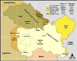
Gilgit-Baltistan is the northernmost political entity within Pakistan. It borders Pakistan's Khyber Pukhtunkhwa province to the west, Afghanistan
's Wakhan Corridor
to the north, China
to the east and northeast, Azad Kashmir
to the southwest, and Indian-administered Jammu and Kashmir
to the southeast. Gilgit-Baltistan covers an area of 72,971 km² (28,174 mi²) and is highly mountainous. It has an estimated population approaching 1,000,000. Its administrative center is the city of Gilgit
(population 216,760).
The territory became a single administrative unit in 1970 under the name Northern Areas and was formed by the amalgamation of the Gilgit Agency
, the Baltistan District
of the Ladakh Wazarat, and the states of Hunza
and Nagar. Gilgit-Baltistan and the neighboring Azad Kashmir together constitute the distputed region, referred to as Pakistan-administered Kashmir
by the United Nations
and other international organisations, and as Pakistan-occupied Kashmir in India.
s) and inscriptions all along the Karakoram Highway
in Gilgit-Baltistan, concentrated at ten major sites between Hunza
and Shatial. The carvings were left by various invaders, traders, and pilgrim
s who passed along the trade route, as well as by locals. The earliest date back to between 5000 and 1000 BCE
, showing single animals, triangular men and hunting scenes in which the animals are larger than the hunters. These carvings
were pecked into the rock with stone tools and are covered with a thick patina
that proves their age.
The ethnologist Karl Jettmar has pieced together the history of the area from various inscriptions and recorded his findings in Rock Carvings and Inscriptions in the Northern Areas of Pakistan and the later released Between Gandhara and the Silk Roads - Rock Carvings Along the Karakoram Highway. Many of these carvings and inscriptions will be inundated and/or destroyed when the planned Basha-Diamir dam is built and the Karakoram Highway widened.
Before the independence of Pakistan
and the partition of India
in 1947, Maharaja
Hari Singh
extended his rule to Gilgit
and Baltistan
. After the partition, Jammu and Kashmir, in its entirety, remained an independent state. The Pakistani parts of Kashmir
to the north and west of the cease-fire line established at the end of the Indo-Pakistani War of 1947
, or the Line of Control
as it later came to be called, were divided into the Northern Areas (72,971 km²) in the north and the Pakistani state of Azad Kashmir
(13,297 km²) in the south. The name "Northern Areas" was first used by the United Nations
to refer to the northern areas of Kashmir
. A small part of the Northern Areas, the Shaksgam tract
, was provisionally ceded by Pakistan to the People's Republic of China in 1963.
Gilgit-Baltistan, which was most recently known as the Northern Areas, presently consists of seven districts, has a population approaching one million, has an area of approximately 28000 square miles (72,519.7 km²), and shares borders with Pakistan, China, Afghanistan, and India. According to the Pakistani newspaper Daily Times, the people of Gilgit-Baltistan were liberated from the Dogra
regime with the aid of the Pakistani army on 1 November 1947. The newspaper further states that while the area was independent for less than a month, they specifically requested the aid of the Pakistani government due to a lack of administrative infrastructure, and were thus incorporated into Pakistan upon the request of local residents.
The local Northern Light Infantry
is the army unit that was believed to have assisted and possibly participated in the 1999 Kargil conflict
. More than 500 soldiers were believed to have been killed and buried in the Northern Areas in that action. Lalak Jan
, an Shia Imami Ismaili Muslim(Nizari) soldier from Yasin Valley
, was awarded Pakistan's most prestigious medal, the Nishan-e-Haider
, for his courageous actions during the Kargil conflict.
. The order granted self-rule to the people of Gilgit-Baltistan, by creating, among other things, an elected legislative assembly. Gilgit-Baltistan thus gained de facto province-like status without having so constitutionally. There has been criticism and opposition to this move in Pakistan, India, and Pakistan administrated Kashmir.
On 29 September 2009, the Pakistani Prime Minister, while addressing a huge gathering in Gilgit-Baltistan, announced a multi-billion rupee development package aimed at the socio-economic uplifting of people in the area. Development projects will include the areas of education, health, agriculture, tourism and the basic needs of life.
The Prime Minister further went on to say:
"You are getting your identity today. It is your right and has been your demand, and today we are fulfilling it."
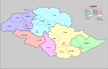 Gilgit-Baltistan is administratively divided into two divisions which, in turn, are divided into seven districts, including the two Baltistan
districts of Skardu
and Ghanche
, and the five Gilgit
districts of Gilgit
, Ghizer
, Diamer
, Astore
, and Hunza-Nagar
. The main political centres are the towns of Gilgit
and Skardu
.
 Gilgit-Baltistan borders the Wakhan corridor of Afghanistan to the northwest, China's Uygur Autonomous Region of Xinjiang to the northeast, the Indian state of Jammu and Kashmir to the south and southeast, the Pakistani-controlled state of Azad Jammu and Kashmir to the south, and Pakistan's North-West Frontier Province to the west.
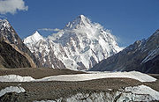
Gilgi-Baltistan is home to five of the "eight-thousander
s" and to more than fifty peaks above 7000 meters. Gilgit
and Skardu
are the two main hubs for expeditions to those mountains. The region is home to some of the world's highest mountain ranges—the main ranges are the Karakoram
and the western Himalayas
. The Pamir
mountains are to the north, and the Hindu Kush
lies to the west. Amongst the highest mountains are K2
(Mount Godwin-Austen) and Nanga Parbat
, the latter being one of the most feared mountains in the world.
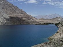
Three of the world's longest glaciers outside the polar regions are found in Gilgit-Baltistan — the Biafo Glacier
, the Baltoro Glacier
, and the Batura Glacier
. There are, in addition, several high-altitude lakes in Gilgit-Baltistan:
The Deosai Plains, are located above the tree line, and constitute the second-highest plateau in the world at 4,115 meters (14,500 feet)after Tibet
. The plateau lies east of Astore, south of Skardu
and west of Ladakh
. The area was declared as a national park
in 1993. The Deosai Plains cover an area of almost 5,000 square kilometres. For over half the year (between September and May), Deosai is snow-bound and cut off from rest of Astore & Baltistan in winters. The village of Deosai lies close to Chilum chokki and is connected with the Kargil district of Ladakh through an all-weather road.
and Hindu Kush
the climate dries considerably.
There are towns like Gilgit
and Chilas
that are very hot during the day in summer, yet cold at night, and valleys like Astore
, Khaplu
, Yasin
, Hunza
, and Nagar
where the temperatures are cold even in summer.
In early September 2009, Pakistan
signed an agreement with the People's Republic of China
for a mega energy project in Gilgit-Baltistan which includes the construction of a 7,000-megawatt dam at Bunji in the Astore District
. This also resulted in protest from India
, although Indian concerns were immediately rejected by Pakistan, which claimed that the Government of India
has no locus standi in the matter.
is the favourite game of the people of Gilgit, Chilas, Astore, Hunza, Nagar and the surrounding areas. Every year, many tourists visit to enjoy polo in Gilgit-Baltistan. Other games such as cricket
, Tuksori of Nagar
, gulli danda, kabbadi, and volleyball
are also played.
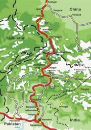
The Karakoram Highway
(KKH) connects Islamabad
to Gilgit
and Skardu
, which are the two major hubs for mountaineering expeditions in Gilgit-Baltistan. The journey from Rawalpindi
/Islamabad
to Gilgit
takes approximately 20 to 24 hours. Landslides on the Karakoram Highway
are very common. The KKH connects Gilgit
to Tashkurgan and Kashgar
in China via Sust
(the customs and health inspection post on the Northern Areas side) and the Khunjerab Pass
, the highest paved international border crossing in the world at 4,693 metres (15,397 feet).
Northern Areas Transport Corporation
(NATCO) offers bus and jeep transport service to the two hubs and several other popular destinations, lakes, and glaciers in the area.
 In March 2006, the respective governments announced that, commencing on June 1, 2006, a thrice-weekly bus service would begin across the boundary from Gilgit to Kashgar
, China
, and road widening work would begin on 600 kilometres of the Karakoram Highway. There would also be one daily bus in each direction between the Sust
and Tashkurgan border areas of the two political entities.
Pakistan International Airlines
used to fly a Fokker F27
aircraft daily between Gilgit Airport
and Islamabad International Airport. The flying time was approximately 50 minutes, and the flight was one of the most scenic in the world, as its route passed over Nanga Parbat
, the peak of which mountain was higher than the aircraft's cruising altitude. However, the Fokker F27 aircraft was retired after a crash at Multan in 2006. Currently, flights are being operated by PIA to Gilgit on the brand-new ATR42-500 aircraft, which was purchased in 2006. With the new plane, cancellation of flights is much less frequent. PIA
also offers regular flights of a Boeing 737
between Skardu
and Islamabad
. All flights, however, are subject to weather clearance, and, in winter, flights are often delayed by several days.
is the lingua franca
of the region, understood by most of the inhabitants. The Shina language
(with several dialects like Asturjaa, Kharuchaa, chilasi) is the language of 60% of the population, spoken mainly in Gilgit, Astore throughout Diamer, and in some parts of Ghizer. The Balti dialect, a sub-dialect of Ladakhi and part of the Tibetan languages group, is spoken by the entire population of Baltistan. Minor languages spoken in the region include Wakhi
, spoken in upper Hunza, and in some villages in Ghizer, while Khowar
is the language of Ghizer. Burushaski is an isolated language spoken in Hunza
, Nagar
, Yasin
(where Khowar is also spoken), in some parts of Gilgit and in some villages of Punyal
. Another interesting language is Domaaki
, spoken by the musician clans in the region. A small minority of people also speak Pashto
.
Despite being referred to as part of Kashmir, Gilgit-Baltistan has few remnants of Kashmiri
. At the last census (1998), the population of Gilgit and Baltistan was 870,347. Approximately 14% of the population was urban.
Afghanistan
Afghanistan , officially the Islamic Republic of Afghanistan, is a landlocked country located in the centre of Asia, forming South Asia, Central Asia and the Middle East. With a population of about 29 million, it has an area of , making it the 42nd most populous and 41st largest nation in the world...
's Wakhan Corridor
Wakhan Corridor
Wakhan Corridor is commonly used as a synonym for Wakhan, an area of far north-eastern Afghanistan which forms a land link or "corridor" between Afghanistan and China. The Corridor is a long and slender panhandle or salient, roughly long and between wide. It separates Tajikistan in the north...
to the north, China
China
Chinese civilization may refer to:* China for more general discussion of the country.* Chinese culture* Greater China, the transnational community of ethnic Chinese.* History of China* Sinosphere, the area historically affected by Chinese culture...
to the east and northeast, Azad Kashmir
Azad Kashmir
Azad Jammu and Kashmir or Azad Kashmir for short, is the southernmost political entity within the Pakistani-administered part of the former princely state of Jammu and Kashmir...
to the southwest, and Indian-administered Jammu and Kashmir
Jammu and Kashmir
Jammu and Kashmir is the northernmost state of India. It is situated mostly in the Himalayan mountains. Jammu and Kashmir shares a border with the states of Himachal Pradesh and Punjab to the south and internationally with the People's Republic of China to the north and east and the...
to the southeast. Gilgit-Baltistan covers an area of 72,971 km² (28,174 mi²) and is highly mountainous. It has an estimated population approaching 1,000,000. Its administrative center is the city of Gilgit
Gilgit
Gilgit is a city in northern PakistanGilgit may refer to other terms related with the area of the city:* Gilgit River* Gilgit Valley* Gilgit District* Gilgit Agency * Gilgit Airport...
(population 216,760).
The territory became a single administrative unit in 1970 under the name Northern Areas and was formed by the amalgamation of the Gilgit Agency
Gilgit Agency
The Gilgit Agency was a political unit of British India, which administered the northern half of the Princely state of Jammu and Kashmir. The Gilgit Agency was created in 1877 and was overseen by a political agent of the Governor-General of British India. The seat of the agent was Srinagar...
, the Baltistan District
Baltistan
Baltistan , also known as بلتیول བལིུལ་ in the Balti language, is a region in northern Pakistan which forms Gilgit-Baltistan, bordering the Xinjiang Autonomous Region of China. In addition, a part of Baltistan also falls into Jammu and Kashmir of India. It is situated in the Karakoram mountains...
of the Ladakh Wazarat, and the states of Hunza
Hunza (princely state)
Hunza was a princely state in the northernmost part of the Northern Areas of Pakistan until 1974. The state was also known as Kanjut. The state bordered the Gilgit Agency to the south, the former princely state of Nagar to the east, China, to the north and Afghanistan to the northwest. The state...
and Nagar. Gilgit-Baltistan and the neighboring Azad Kashmir together constitute the distputed region, referred to as Pakistan-administered Kashmir
Pakistan-administered Kashmir
Azad Kashmir borders the Pakistani provinces of Punjab and Khyber Pakhtunkhwa to the west, the Wakhan Corridor of Afghanistan to the north west, the Xinjiang Uyghur Autonomous Region of People's Republic of China to the north and the Indian-administered state of Jammu and Kashmir, to the east.A...
by the United Nations
United Nations
The United Nations is an international organization whose stated aims are facilitating cooperation in international law, international security, economic development, social progress, human rights, and achievement of world peace...
and other international organisations, and as Pakistan-occupied Kashmir in India.
Rock art and petroglyphs
There are more than 50,000 pieces of rock art (petroglyphPetroglyph
Petroglyphs are pictogram and logogram images created by removing part of a rock surface by incising, picking, carving, and abrading. Outside North America, scholars often use terms such as "carving", "engraving", or other descriptions of the technique to refer to such images...
s) and inscriptions all along the Karakoram Highway
Karakoram Highway
The Karakoram Highway is the highest paved international road in the world, but at its peak at the China-Pakistan border it is only paved on the Chinese side. It connects China and Pakistan across the Karakoram mountain range, through the Khunjerab Pass, at an altitude of as confirmed by both...
in Gilgit-Baltistan, concentrated at ten major sites between Hunza
Hunza (princely state)
Hunza was a princely state in the northernmost part of the Northern Areas of Pakistan until 1974. The state was also known as Kanjut. The state bordered the Gilgit Agency to the south, the former princely state of Nagar to the east, China, to the north and Afghanistan to the northwest. The state...
and Shatial. The carvings were left by various invaders, traders, and pilgrim
Pilgrim
A pilgrim is a traveler who is on a journey to a holy place. Typically, this is a physical journeying to some place of special significance to the adherent of a particular religious belief system...
s who passed along the trade route, as well as by locals. The earliest date back to between 5000 and 1000 BCE
Common Era
Common Era ,abbreviated as CE, is an alternative designation for the calendar era originally introduced by Dionysius Exiguus in the 6th century, traditionally identified with Anno Domini .Dates before the year 1 CE are indicated by the usage of BCE, short for Before the Common Era Common Era...
, showing single animals, triangular men and hunting scenes in which the animals are larger than the hunters. These carvings
Stone carving
Stone carving is an ancient activity where pieces of rough natural stone are shaped by the controlled removal of stone. Owing to the permanence of the material, evidence can be found that even the earliest societies indulged in some form of stone work....
were pecked into the rock with stone tools and are covered with a thick patina
Patina
Patina is a tarnish that forms on the surface of bronze and similar metals ; a sheen on wooden furniture produced by age, wear, and polishing; or any such acquired change of a surface through age and exposure...
that proves their age.
The ethnologist Karl Jettmar has pieced together the history of the area from various inscriptions and recorded his findings in Rock Carvings and Inscriptions in the Northern Areas of Pakistan and the later released Between Gandhara and the Silk Roads - Rock Carvings Along the Karakoram Highway. Many of these carvings and inscriptions will be inundated and/or destroyed when the planned Basha-Diamir dam is built and the Karakoram Highway widened.
Before the independence of Pakistan
Pakistan
Pakistan , officially the Islamic Republic of Pakistan is a sovereign state in South Asia. It has a coastline along the Arabian Sea and the Gulf of Oman in the south and is bordered by Afghanistan and Iran in the west, India in the east and China in the far northeast. In the north, Tajikistan...
and the partition of India
Partition of India
The Partition of India was the partition of British India on the basis of religious demographics that led to the creation of the sovereign states of the Dominion of Pakistan and the Union of India on 14 and 15...
in 1947, Maharaja
Maharaja
Mahārāja is a Sanskrit title for a "great king" or "high king". The female equivalent title Maharani denotes either the wife of a Maharaja or, in states where that was customary, a woman ruling in her own right. The widow of a Maharaja is known as a Rajamata...
Hari Singh
Hari Singh
Maharaja Hari Singh was the last ruling Maharaja of the princely state of Jammu and Kashmir in India.He was married four times...
extended his rule to Gilgit
Gilgit Agency
The Gilgit Agency was a political unit of British India, which administered the northern half of the Princely state of Jammu and Kashmir. The Gilgit Agency was created in 1877 and was overseen by a political agent of the Governor-General of British India. The seat of the agent was Srinagar...
and Baltistan
Baltistan
Baltistan , also known as بلتیول བལིུལ་ in the Balti language, is a region in northern Pakistan which forms Gilgit-Baltistan, bordering the Xinjiang Autonomous Region of China. In addition, a part of Baltistan also falls into Jammu and Kashmir of India. It is situated in the Karakoram mountains...
. After the partition, Jammu and Kashmir, in its entirety, remained an independent state. The Pakistani parts of Kashmir
Pakistan-administered Kashmir
Azad Kashmir borders the Pakistani provinces of Punjab and Khyber Pakhtunkhwa to the west, the Wakhan Corridor of Afghanistan to the north west, the Xinjiang Uyghur Autonomous Region of People's Republic of China to the north and the Indian-administered state of Jammu and Kashmir, to the east.A...
to the north and west of the cease-fire line established at the end of the Indo-Pakistani War of 1947
Indo-Pakistani War of 1947
The India-Pakistan War of 1947-48, sometimes known as the First Kashmir War, was fought between India and Pakistan over the princely state of Kashmir and Jammu from 1947 to 1948. It was the first of four wars fought between the two newly independent nations...
, or the Line of Control
Line of Control
The term Line of Control refers to the military control line between the Indian- and Pakistani-controlled parts of the former princely state of Jammu and Kashmir—a line which, to this day, does not constitute a legally recognized international boundary but is the de facto border...
as it later came to be called, were divided into the Northern Areas (72,971 km²) in the north and the Pakistani state of Azad Kashmir
Azad Kashmir
Azad Jammu and Kashmir or Azad Kashmir for short, is the southernmost political entity within the Pakistani-administered part of the former princely state of Jammu and Kashmir...
(13,297 km²) in the south. The name "Northern Areas" was first used by the United Nations
United Nations
The United Nations is an international organization whose stated aims are facilitating cooperation in international law, international security, economic development, social progress, human rights, and achievement of world peace...
to refer to the northern areas of Kashmir
Kashmir
Kashmir is the northwestern region of the Indian subcontinent. Until the mid-19th century, the term Kashmir geographically denoted only the valley between the Great Himalayas and the Pir Panjal mountain range...
. A small part of the Northern Areas, the Shaksgam tract
Trans-Karakoram Tract
The Trans-Karakoram Tract is an area of nearly along both sides of the Shaksgam River, is entirely administered by the People's Republic of China as a part of Kargilik County and Taxkorgan Tajik Autonomous County in the Kashgar Prefecture of Xinjiang Autonomous Region, but claimed by Pakistan...
, was provisionally ceded by Pakistan to the People's Republic of China in 1963.
Gilgit-Baltistan, which was most recently known as the Northern Areas, presently consists of seven districts, has a population approaching one million, has an area of approximately 28000 square miles (72,519.7 km²), and shares borders with Pakistan, China, Afghanistan, and India. According to the Pakistani newspaper Daily Times, the people of Gilgit-Baltistan were liberated from the Dogra
Dogra
The Dogras are an Indo-Aryan ethnic group in South Asia. Being a diversified group, the Dogras include both Savarnas such as Brahmins, Rajputs and Non-savarnas. The Dogras also incluide merchant castes such as Mahajans...
regime with the aid of the Pakistani army on 1 November 1947. The newspaper further states that while the area was independent for less than a month, they specifically requested the aid of the Pakistani government due to a lack of administrative infrastructure, and were thus incorporated into Pakistan upon the request of local residents.
The local Northern Light Infantry
Northern Light Infantry
The Northern Light Infantry is a Light Infantry Regiment of the Pakistan Army. Headquartered in Gilgit, the capital of Northern Areas, Pakistan, it is the main force protecting the strategically important northern areas of Pakistan. The majority of this regiment's personnel come from native...
is the army unit that was believed to have assisted and possibly participated in the 1999 Kargil conflict
Kargil War
The Kargil War ,, also known as the Kargil conflict, was an armed conflict between India and Pakistan that took place between May and July 1999 in the Kargil district of Kashmir and elsewhere along the Line of Control...
. More than 500 soldiers were believed to have been killed and buried in the Northern Areas in that action. Lalak Jan
Lalak Jan
Havaldar Lalak Jan Shaahed was born in Yasin, in the Ghizer District, of the Northern Areas of Pakistan...
, an Shia Imami Ismaili Muslim(Nizari) soldier from Yasin Valley
Yasin Valley
The Yasin Valley, Tehsil Yasin or Babaye-i-Yasen or Worshigum is a high mountain valley in the Hindu Kush mountains, in the northwest region of Gilgit in Gilgit-Baltistan, Pakistan. Yasin is separated from the Ishkoman Valley by a high mountain pass...
, was awarded Pakistan's most prestigious medal, the Nishan-e-Haider
Nishan-e-Haider
Nishan-e-Haider or Nishan-e-Hyder is the highest military decoration given by Pakistan . It was established in 1957 after Pakistan became a Republic, however, it was instituted retrospectively from Independence in 1947...
, for his courageous actions during the Kargil conflict.
Autonomous status and present-day Gilgit-Baltistan
The main demand of the Gilgit-Baltistani people is to integrate their area into Pakistan and make it constitutionally a Pakistani province. On 29 August 2009, the Gilgit-Baltistan Empowerment and Self-Governance Order, 2009, was passed by the Pakistani cabinet and later signed by the President of PakistanPresident of Pakistan
The President of Pakistan is the head of state, as well as figurehead, of the Islamic Republic of Pakistan. Recently passed an XVIII Amendment , Pakistan has a parliamentary democratic system of government. According to the Constitution, the President is chosen by the Electoral College to serve a...
. The order granted self-rule to the people of Gilgit-Baltistan, by creating, among other things, an elected legislative assembly. Gilgit-Baltistan thus gained de facto province-like status without having so constitutionally. There has been criticism and opposition to this move in Pakistan, India, and Pakistan administrated Kashmir.
On 29 September 2009, the Pakistani Prime Minister, while addressing a huge gathering in Gilgit-Baltistan, announced a multi-billion rupee development package aimed at the socio-economic uplifting of people in the area. Development projects will include the areas of education, health, agriculture, tourism and the basic needs of life.
The Prime Minister further went on to say:
"You are getting your identity today. It is your right and has been your demand, and today we are fulfilling it."
Subdivisions
Baltistan
Baltistan , also known as بلتیول བལིུལ་ in the Balti language, is a region in northern Pakistan which forms Gilgit-Baltistan, bordering the Xinjiang Autonomous Region of China. In addition, a part of Baltistan also falls into Jammu and Kashmir of India. It is situated in the Karakoram mountains...
districts of Skardu
Skardu District
Skardu District is part of Baltistan and currently constitutes one of the seven districts of the Gilgit-Baltistan territory of Pakistan...
and Ghanche
Ghanche District
Ghanche District is the easternmost district of Gilgit-Baltistan, Pakistan. To its northeast is Xinjiang , to the north and northwest is Skardu District, to its west is Astore District and to its south is Ladakh District in the Indian state of Jammu and Kashmir...
, and the five Gilgit
Gilgit
Gilgit is a city in northern PakistanGilgit may refer to other terms related with the area of the city:* Gilgit River* Gilgit Valley* Gilgit District* Gilgit Agency * Gilgit Airport...
districts of Gilgit
Gilgit District
Gilgit District is one of the districts of the federal territory of Gilgit-Baltistan in northern Pakistan. It was formed in 1970 when Gilgit-Baltistan was federally administered as the "Northern Areas". It is bounded by the Wakhan Corridor to the north; Xinjiang to the northeast and east; Skardu,...
, Ghizer
Ghizer District
Ghizer District is northernmost part of the Northern Areas of Pakistan. Its capital is Gakuch. Ghizer is also a contact point between Gilgit and Chitral and also it is contact point to China, Tajikistan via Qurumber pass through Ishkomen/Darkut Yasin . Ghizer is a multi ethnic district and three...
, Diamer
Diamer District
Diamer District is one of the seven districts of the Northern Areas of Pakistan. It is the district in which the Karakoram Highway enters that territory from the North-West Frontier Province, the capital of the district is Chilas...
, Astore
Astore District
Astore is one of the six districts of the Gilgit Baltistan. The district contains the Astore Valley and is bounded to the west by Diamer District , to the north by Gilgit District, to the east by Skardu District and to the south by Khyber-Pakhtunkhwa and Neelum District of Azad Kashmir...
, and Hunza-Nagar
Hunza-Nagar District
The Hunza-Nagar District is the seventh district of Gilgit-Baltistan of Pakistan. The district comprises Hunza and Nagar. Aliabad is the administrative center of this district...
. The main political centres are the towns of Gilgit
Gilgit
Gilgit is a city in northern PakistanGilgit may refer to other terms related with the area of the city:* Gilgit River* Gilgit Valley* Gilgit District* Gilgit Agency * Gilgit Airport...
and Skardu
Skardu
Skardu , is the main town of the region Baltistan and the capital of Skardu District, one of the districts making up Pakistan's Gilgit Baltistan....
.
| Division | District | Area (km²) | Population (1998) | Headquarters |
|---|---|---|---|---|
| Baltistan | Ghanche Ghanche District Ghanche District is the easternmost district of Gilgit-Baltistan, Pakistan. To its northeast is Xinjiang , to the north and northwest is Skardu District, to its west is Astore District and to its south is Ladakh District in the Indian state of Jammu and Kashmir... |
9,400 | 88,366 | Khaplu Khaplu Khaplu is the capital town of the Ghangche District of Gilgit-Baltistan. Lying east of Skardu town, it was the second-largest kingdom in old Baltistan. It guarded the trade route to Ladakh along the Shyok River... |
| Skardu Skardu District Skardu District is part of Baltistan and currently constitutes one of the seven districts of the Gilgit-Baltistan territory of Pakistan... |
18,000 | 214,848 | Skardu Skardu Skardu , is the main town of the region Baltistan and the capital of Skardu District, one of the districts making up Pakistan's Gilgit Baltistan.... |
|
| Gilgit | Gilgit Gilgit District Gilgit District is one of the districts of the federal territory of Gilgit-Baltistan in northern Pakistan. It was formed in 1970 when Gilgit-Baltistan was federally administered as the "Northern Areas". It is bounded by the Wakhan Corridor to the north; Xinjiang to the northeast and east; Skardu,... |
39,300 | 383,324 | Gilgit Gilgit Gilgit is a city in northern PakistanGilgit may refer to other terms related with the area of the city:* Gilgit River* Gilgit Valley* Gilgit District* Gilgit Agency * Gilgit Airport... |
| Diamir Diamer District Diamer District is one of the seven districts of the Northern Areas of Pakistan. It is the district in which the Karakoram Highway enters that territory from the North-West Frontier Province, the capital of the district is Chilas... |
10,936 | 131,925 | Chilas Chilas Chilas is a small town located in the Gilgit-Baltistan, Pakistan on the left side of river Indus. It is part of the Silk Road connected by the Karakoram Highway which links it to Islamabad in the south via Dassu, Besham, Mansehra, Abbottabad and Haripur... |
|
| |Ghizar Ghizer District Ghizer District is northernmost part of the Northern Areas of Pakistan. Its capital is Gakuch. Ghizer is also a contact point between Gilgit and Chitral and also it is contact point to China, Tajikistan via Qurumber pass through Ishkomen/Darkut Yasin . Ghizer is a multi ethnic district and three... |
9,635 | 120,218 | Gahkuch Gahkuch Gahkuch is the capital of Ghizer District in the Northern Areas of Pakistan, the town lies en route to Ishkoman. It is a beautiful city covered by mountains. It is situated 72 kilometeres from Gilgit, the capital of the autonomous province, Gilgit-Baltistan of Pakistan.... |
|
| Astore Astore District Astore is one of the six districts of the Gilgit Baltistan. The district contains the Astore Valley and is bounded to the west by Diamer District , to the north by Gilgit District, to the east by Skardu District and to the south by Khyber-Pakhtunkhwa and Neelum District of Azad Kashmir... |
8,657 | 71,666 | Gorikot Gorikot Gorikot is the largest valley in the Astore District of Northern Areas of Pakistan, now home to most district government offices. The local name for the town is Gué... |
|
| Hunza-Nagar Hunza-Nagar District The Hunza-Nagar District is the seventh district of Gilgit-Baltistan of Pakistan. The district comprises Hunza and Nagar. Aliabad is the administrative center of this district... |
| Aliabad Aliabad Aliabad is one of the old suburbs in Hyderabad, India. It is part of the old city of Hyderabad. It is very close to the historic Charminar.Aliabad is situated about 2.5 km from Charminar towards Falaknuma palace. Aliabad Darwaza is one of the 8 entrances to the erstwhile Hyderabad... , Sikandarabad Sikandarabad Sikandarabad is the located in Hunza-Nagar District of Gilgit-Baltistan in Pakistan.-See also:* Former State of Hunza* Baltit Fort* Altit Fort* Northern Areas* Karakoram Highway* Karakoram Mountains* Nagar Valley* Burusho* Ganish Village... |
|||
| Gilgit-Baltistan totals | 7 districts | 72,971 | 970,347 | Gilgit Gilgit Gilgit is a city in northern PakistanGilgit may refer to other terms related with the area of the city:* Gilgit River* Gilgit Valley* Gilgit District* Gilgit Agency * Gilgit Airport... |
Geography and climate
Gilgi-Baltistan is home to five of the "eight-thousander
Eight-thousander
The eight-thousanders are the fourteen independent mountains on Earth that are more than high above sea level. They are all located in the Himalayan and Karakoram mountain ranges in Asia....
s" and to more than fifty peaks above 7000 meters. Gilgit
Gilgit
Gilgit is a city in northern PakistanGilgit may refer to other terms related with the area of the city:* Gilgit River* Gilgit Valley* Gilgit District* Gilgit Agency * Gilgit Airport...
and Skardu
Skardu
Skardu , is the main town of the region Baltistan and the capital of Skardu District, one of the districts making up Pakistan's Gilgit Baltistan....
are the two main hubs for expeditions to those mountains. The region is home to some of the world's highest mountain ranges—the main ranges are the Karakoram
Karakoram
The Karakoram, or Karakorum , is a large mountain range spanning the borders between Pakistan, India and China, located in the regions of Gilgit-Baltistan , Ladakh , and Xinjiang region,...
and the western Himalayas
Himalayas
The Himalaya Range or Himalaya Mountains Sanskrit: Devanagari: हिमालय, literally "abode of snow"), usually called the Himalayas or Himalaya for short, is a mountain range in Asia, separating the Indian subcontinent from the Tibetan Plateau...
. The Pamir
Pamir Mountains
The Pamir Mountains are a mountain range in Central Asia formed by the junction or knot of the Himalayas, Tian Shan, Karakoram, Kunlun, and Hindu Kush ranges. They are among the world’s highest mountains and since Victorian times they have been known as the "Roof of the World" a probable...
mountains are to the north, and the Hindu Kush
Hindu Kush
The Hindu Kush is an mountain range that stretches between central Afghanistan and northern Pakistan. The highest point in the Hindu Kush is Tirich Mir in the Chitral region of Khyber-Pakhtunkhwa, Pakistan.It is the westernmost extension of the Pamir Mountains, the Karakoram Range, and is a...
lies to the west. Amongst the highest mountains are K2
K2
K2 is the second-highest mountain on Earth, after Mount Everest...
(Mount Godwin-Austen) and Nanga Parbat
Nanga Parbat
Nanga Parbat is the ninth highest mountain on Earth, the second highest mountain in Pakistan and among the eight-thousanders with a summit elevation of 8,126 meters...
, the latter being one of the most feared mountains in the world.
Three of the world's longest glaciers outside the polar regions are found in Gilgit-Baltistan — the Biafo Glacier
Biafo Glacier
The Biafo Glacier is a long glacier in the Karakoram Mountains of the Northern Areas, Pakistan which meets the long Hispar Glacier at an altitude of at Hispar La to create the world's longest glacial system outside the polar regions. This highway of ice connects two ancient mountain kingdoms,...
, the Baltoro Glacier
Baltoro Glacier
The Baltoro Glacier, at 62 kilometers long, is one of the longest glaciers outside the polar regions. It is located in Baltistan, in the Gilgit-Baltistan region of Pakistan, and runs through part of the Karakoram mountain range. The Baltoro Muztagh lies to the north and east of the glacier, while...
, and the Batura Glacier
Batura Glacier
Batura Glacier is one of the largest and longest glaciers outside the polar regions. It lies in the Gojal region of the Northern Areas of Pakistan, just north of Batura and Passu massifs. It flows west to east...
. There are, in addition, several high-altitude lakes in Gilgit-Baltistan:
- Sheosar LakeSheosar LakeSheosar Lake is a lake situated in Deosai National Park, in Gilgit-Baltistan province of northern Pakistan....
in Deosai Plains - AstoreAstoreAstore may refer to:*Astore District*Astore River*Astore Valley*Astore, Pakistan*Astore Sports, a sports brand...
region - Satpara Tso LakeSatpara LakeSatpara Lake is a natural lake near Skardu, Gilgit-Baltistan, Pakistan, which supplies water to Skardu Valley. It is fed by the Satpara Stream....
in SkarduSkarduSkardu , is the main town of the region Baltistan and the capital of Skardu District, one of the districts making up Pakistan's Gilgit Baltistan....
- Baltistan - Katzura Tso LakeKachura LakeThe Kachura Lakes are two lakes in the Skardu District of Gilgit-Baltistan, northern Pakistan. The lakes, at in elevation, are Upper Kachura Lake and Lower Kachura Lake...
in SkarduSkarduSkardu , is the main town of the region Baltistan and the capital of Skardu District, one of the districts making up Pakistan's Gilgit Baltistan....
- Baltistan - Zharba Tso Lake in ShigarShigarShigar is a town in Baltistan near Skardu in northern Pakistan. Nearby is the Shigar River.-External links:* *...
- Baltistan - Phoroq Tso Lake in Skardu - Baltistan
- Bara Tso Lake in Gangche - Baltistan
- Byarsa Tso Lake in Gultari - Baltistan
- Borith LakeBorith LakeBorith Lake is a lake in the Northern Areas of Pakistan. Borith is a hamlet in the surroundings of the Borith Lake to the northwest of Husseini, a village near Gulmit, Gojal, in the upper Hunza...
in Gojal upper HunzaHunza (princely state)Hunza was a princely state in the northernmost part of the Northern Areas of Pakistan until 1974. The state was also known as Kanjut. The state bordered the Gilgit Agency to the south, the former princely state of Nagar to the east, China, to the north and Afghanistan to the northwest. The state...
- Gilgit - Rama LakeRama Lake (Pakistan)Rama Lake is a lake near Astore in Gilgit-Baltistan, Pakistan. It is on the top of the beautiful Astore Valley, covered with oak trees and greenery.- Location :...
near AstoreAstore, PakistanAstore, also spelt Astor, is the capital of Astore District in the Gilgit-Baltistan region of northern Pakistan. It is located at 35°22'0N 74°51'0E with an altitude of 2546 metres and is the coldest place within the country, with temperatures reaching −26 degrees Celsius.... - Rush LakeRush Lake (Pakistan)Rush Lake is a high altitude lake located near Rush Pari Peak . At over 4,694 meters, Rush is one of the highest alpine lakes in the world. It is located about 15 km north of Miar Peak and Spantik , which are in the Nagar valley...
near NagarNagar, PakistanNagar is a town near to the Gilgit Valley in the Gilgit-Baltistan region of northern Pakistan. The town is located in Hunza–Nagar District and was the capital of the former State of Nagar...
- Gilgit - Kromber LakeKarambar LakeKaromber Lake is a high altitude lake located in Ishkoman in the Northern Areas of Pakistan. It is the 31st highest lakes in the world at a height of . Karambar lake is considered as one of the most beautiful mountain lake in the world. you can see high pamir mountains all around the lake with long...
In Kromber Pass - Ishkoman Valley, Ghizer District - Barodaroksh lake in Bar valley Nagar
The Deosai Plains, are located above the tree line, and constitute the second-highest plateau in the world at 4,115 meters (14,500 feet)after Tibet
Tibet
Tibet is a plateau region in Asia, north-east of the Himalayas. It is the traditional homeland of the Tibetan people as well as some other ethnic groups such as Monpas, Qiang, and Lhobas, and is now also inhabited by considerable numbers of Han and Hui people...
. The plateau lies east of Astore, south of Skardu
Skardu
Skardu , is the main town of the region Baltistan and the capital of Skardu District, one of the districts making up Pakistan's Gilgit Baltistan....
and west of Ladakh
Ladakh
Ladakh is a region of Jammu and Kashmir, the northernmost state of the Republic of India. It lies between the Kunlun mountain range in the north and the main Great Himalayas to the south, inhabited by people of Indo-Aryan and Tibetan descent...
. The area was declared as a national park
National park
A national park is a reserve of natural, semi-natural, or developed land that a sovereign state declares or owns. Although individual nations designate their own national parks differently A national park is a reserve of natural, semi-natural, or developed land that a sovereign state declares or...
in 1993. The Deosai Plains cover an area of almost 5,000 square kilometres. For over half the year (between September and May), Deosai is snow-bound and cut off from rest of Astore & Baltistan in winters. The village of Deosai lies close to Chilum chokki and is connected with the Kargil district of Ladakh through an all-weather road.
Climate
The climate of Gilgit-Baltistan varies from region to region, surrounding mountain ranges creates sharp variations in weather. The eastern part has the moist zone of the western Himalayas, but going toward KarakoramKarakoram
The Karakoram, or Karakorum , is a large mountain range spanning the borders between Pakistan, India and China, located in the regions of Gilgit-Baltistan , Ladakh , and Xinjiang region,...
and Hindu Kush
Hindu Kush
The Hindu Kush is an mountain range that stretches between central Afghanistan and northern Pakistan. The highest point in the Hindu Kush is Tirich Mir in the Chitral region of Khyber-Pakhtunkhwa, Pakistan.It is the westernmost extension of the Pamir Mountains, the Karakoram Range, and is a...
the climate dries considerably.
There are towns like Gilgit
Gilgit
Gilgit is a city in northern PakistanGilgit may refer to other terms related with the area of the city:* Gilgit River* Gilgit Valley* Gilgit District* Gilgit Agency * Gilgit Airport...
and Chilas
Chilas
Chilas is a small town located in the Gilgit-Baltistan, Pakistan on the left side of river Indus. It is part of the Silk Road connected by the Karakoram Highway which links it to Islamabad in the south via Dassu, Besham, Mansehra, Abbottabad and Haripur...
that are very hot during the day in summer, yet cold at night, and valleys like Astore
Astore Valley
Astore Valley is now located in Astore District in the autonomous Pakistani regions of Gilgit-Baltistan,previously in the princely state of Jammu and Kashmir. The valley, adjoining the eastern side of mountain Nanga Parbat, is about long, having area of .The entrance of the valley is located...
, Khaplu
Khaplu
Khaplu is the capital town of the Ghangche District of Gilgit-Baltistan. Lying east of Skardu town, it was the second-largest kingdom in old Baltistan. It guarded the trade route to Ladakh along the Shyok River...
, Yasin
Yasin Valley
The Yasin Valley, Tehsil Yasin or Babaye-i-Yasen or Worshigum is a high mountain valley in the Hindu Kush mountains, in the northwest region of Gilgit in Gilgit-Baltistan, Pakistan. Yasin is separated from the Ishkoman Valley by a high mountain pass...
, Hunza
Hunza (princely state)
Hunza was a princely state in the northernmost part of the Northern Areas of Pakistan until 1974. The state was also known as Kanjut. The state bordered the Gilgit Agency to the south, the former princely state of Nagar to the east, China, to the north and Afghanistan to the northwest. The state...
, and Nagar
Nagar Valley
The Nagar Valley is a valley near Gilgit Valley in the Gilgit Baltistan of Pakistan. The valley is part of Hunza Nagar District and is administratively subdivided into two tehsils namely Nagar-1 and Nagar-2. The valley is situated at an elevation of 2,438m . Nagar Khas is the main town and the...
where the temperatures are cold even in summer.
Economy and resources
The economy of region is basically based on traditional route of trade through Silk Road. China Trade organization was the leading economic forum through which most of barter trade activity made a phenomenal change in the general economical outlook of the area which being the remotest region of Pakistan was neglected for over quarter of century. This forum led the people of the area to actively invest and learn the modern trade know how from its neighbor Xingkiang. The participation of the all ethnic groups and active force behind this activity, legendary economist of the area Ashraf Khan brought a great change in the region. Later the establishment of Chamber of commerce and SOst dry port(in Gojal Hunza) are milestones. Rest of the economy is shouldered by mainly agriculture and tourism. Agriculture such as: wheat, corn (maize), barley, fruits; Tourism is mostly in trekking and mountaineering and this industry is 'growing in importance'In early September 2009, Pakistan
Pakistan
Pakistan , officially the Islamic Republic of Pakistan is a sovereign state in South Asia. It has a coastline along the Arabian Sea and the Gulf of Oman in the south and is bordered by Afghanistan and Iran in the west, India in the east and China in the far northeast. In the north, Tajikistan...
signed an agreement with the People's Republic of China
People's Republic of China
China , officially the People's Republic of China , is the most populous country in the world, with over 1.3 billion citizens. Located in East Asia, the country covers approximately 9.6 million square kilometres...
for a mega energy project in Gilgit-Baltistan which includes the construction of a 7,000-megawatt dam at Bunji in the Astore District
Astore District
Astore is one of the six districts of the Gilgit Baltistan. The district contains the Astore Valley and is bounded to the west by Diamer District , to the north by Gilgit District, to the east by Skardu District and to the south by Khyber-Pakhtunkhwa and Neelum District of Azad Kashmir...
. This also resulted in protest from India
India
India , officially the Republic of India , is a country in South Asia. It is the seventh-largest country by geographical area, the second-most populous country with over 1.2 billion people, and the most populous democracy in the world...
, although Indian concerns were immediately rejected by Pakistan, which claimed that the Government of India
Government of India
The Government of India, officially known as the Union Government, and also known as the Central Government, was established by the Constitution of India, and is the governing authority of the union of 28 states and seven union territories, collectively called the Republic of India...
has no locus standi in the matter.
Sports
PoloPolo
Polo is a team sport played on horseback in which the objective is to score goals against an opposing team. Sometimes called, "The Sport of Kings", it was highly popularized by the British. Players score by driving a small white plastic or wooden ball into the opposing team's goal using a...
is the favourite game of the people of Gilgit, Chilas, Astore, Hunza, Nagar and the surrounding areas. Every year, many tourists visit to enjoy polo in Gilgit-Baltistan. Other games such as cricket
Cricket
Cricket is a bat-and-ball game played between two teams of 11 players on an oval-shaped field, at the centre of which is a rectangular 22-yard long pitch. One team bats, trying to score as many runs as possible while the other team bowls and fields, trying to dismiss the batsmen and thus limit the...
, Tuksori of Nagar
Nagar, Pakistan
Nagar is a town near to the Gilgit Valley in the Gilgit-Baltistan region of northern Pakistan. The town is located in Hunza–Nagar District and was the capital of the former State of Nagar...
, gulli danda, kabbadi, and volleyball
Volleyball
Volleyball is a team sport in which two teams of six players are separated by a net. Each team tries to score points by grounding a ball on the other team's court under organized rules.The complete rules are extensive...
are also played.
Transport
Prior to 1978, Gilgit-Baltistan was cut off from Pakistan and rest of the world due to the harsh terrain and the lack of accessible roads. All of the roads to the south opened towards the Pakistani-controlled state of Azad Jammu and Kashmir (AKJ) and to the southeast towards the present-day Indian-controlled state of Jammu and Kashmir. During the summer, people could walk across the mountain passes to travel to Rawalpindi. The fastest way to travel, however, was by air, but air travel was accessible only to a few privileged local people and to Pakistani military and civilian officials. Then, with the assistance of the Chinese government, Pakistan began construction of the Karakoram Highway (KKH), which was completed in 1978.The Karakoram Highway
Karakoram Highway
The Karakoram Highway is the highest paved international road in the world, but at its peak at the China-Pakistan border it is only paved on the Chinese side. It connects China and Pakistan across the Karakoram mountain range, through the Khunjerab Pass, at an altitude of as confirmed by both...
(KKH) connects Islamabad
Islamabad
Islamabad is the capital of Pakistan and the tenth largest city in the country. Located within the Islamabad Capital Territory , the population of the city has grown from 100,000 in 1951 to 1.7 million in 2011...
to Gilgit
Gilgit
Gilgit is a city in northern PakistanGilgit may refer to other terms related with the area of the city:* Gilgit River* Gilgit Valley* Gilgit District* Gilgit Agency * Gilgit Airport...
and Skardu
Skardu
Skardu , is the main town of the region Baltistan and the capital of Skardu District, one of the districts making up Pakistan's Gilgit Baltistan....
, which are the two major hubs for mountaineering expeditions in Gilgit-Baltistan. The journey from Rawalpindi
Rawalpindi
Rawalpindi , locally known as Pindi, is a city in the Pothohar region of Pakistan near Pakistan's capital city of Islamabad, in the province of Punjab. Rawalpindi is the fourth largest city in Pakistan after Karachi, Lahore and Faisalabad...
/Islamabad
Islamabad
Islamabad is the capital of Pakistan and the tenth largest city in the country. Located within the Islamabad Capital Territory , the population of the city has grown from 100,000 in 1951 to 1.7 million in 2011...
to Gilgit
Gilgit
Gilgit is a city in northern PakistanGilgit may refer to other terms related with the area of the city:* Gilgit River* Gilgit Valley* Gilgit District* Gilgit Agency * Gilgit Airport...
takes approximately 20 to 24 hours. Landslides on the Karakoram Highway
Karakoram Highway
The Karakoram Highway is the highest paved international road in the world, but at its peak at the China-Pakistan border it is only paved on the Chinese side. It connects China and Pakistan across the Karakoram mountain range, through the Khunjerab Pass, at an altitude of as confirmed by both...
are very common. The KKH connects Gilgit
Gilgit
Gilgit is a city in northern PakistanGilgit may refer to other terms related with the area of the city:* Gilgit River* Gilgit Valley* Gilgit District* Gilgit Agency * Gilgit Airport...
to Tashkurgan and Kashgar
Kashgar
Kashgar or Kashi is an oasis city with approximately 350,000 residents in the western part of the Xinjiang Uyghur Autonomous Region of the People's Republic of China. Kashgar is the administrative centre of Kashgar Prefecture which has an area of 162,000 km² and a population of approximately...
in China via Sust
Sust
Sust or Sost is a dry port in Gojal region of the Northern Areas of Pakistan. It is the last town inside Pakistan on the Karakoram Highway before the Chinese border...
(the customs and health inspection post on the Northern Areas side) and the Khunjerab Pass
Khunjerab Pass
Khunjerab Pass is a high mountain pass in the Karakoram Mountains in a strategic position on the northern border of Pakistan's Gilgit-Baltistan region within the disputed region of Kashmir and on the southwest border of the Xinjiang region of China...
, the highest paved international border crossing in the world at 4,693 metres (15,397 feet).
Northern Areas Transport Corporation
Northern Areas Transport Corporation
Northern Areas Transport Corporation or NATCO is the largest transport company in Gilgit-Baltistan of Pakistan that provides bus and jeep service on the Karakoram Highway, throughout the Northern Areas....
(NATCO) offers bus and jeep transport service to the two hubs and several other popular destinations, lakes, and glaciers in the area.
Kashgar
Kashgar or Kashi is an oasis city with approximately 350,000 residents in the western part of the Xinjiang Uyghur Autonomous Region of the People's Republic of China. Kashgar is the administrative centre of Kashgar Prefecture which has an area of 162,000 km² and a population of approximately...
, China
China
Chinese civilization may refer to:* China for more general discussion of the country.* Chinese culture* Greater China, the transnational community of ethnic Chinese.* History of China* Sinosphere, the area historically affected by Chinese culture...
, and road widening work would begin on 600 kilometres of the Karakoram Highway. There would also be one daily bus in each direction between the Sust
Sust
Sust or Sost is a dry port in Gojal region of the Northern Areas of Pakistan. It is the last town inside Pakistan on the Karakoram Highway before the Chinese border...
and Tashkurgan border areas of the two political entities.
Pakistan International Airlines
Pakistan International Airlines
Pakistan International Airlines Corporation commonly known as PIA, is the flag carrier airline of Pakistan. The airline has its head office on the grounds of Jinnah International Airport in Karachi. and operates scheduled services to 24 domestic destinations and 38 international destinations in 27...
used to fly a Fokker F27
Fokker F27
The Fokker F27 Friendship is a turboprop airliner designed and built by the Dutch aircraft manufacturer Fokker.-Design and development:Design of the Fokker F27 started in the 1950s as a replacement to the successful Douglas DC-3 airliner...
aircraft daily between Gilgit Airport
Gilgit Airport
Gilgit Airport is a small domestic airport situated 1.25 nm east of Gilgit, a city in the Gilgit-Baltistan region of Pakistan. The city of Gilgit is one of the two major hubs for all mountaineering expeditions in the Northern Areas of Pakistan...
and Islamabad International Airport. The flying time was approximately 50 minutes, and the flight was one of the most scenic in the world, as its route passed over Nanga Parbat
Nanga Parbat
Nanga Parbat is the ninth highest mountain on Earth, the second highest mountain in Pakistan and among the eight-thousanders with a summit elevation of 8,126 meters...
, the peak of which mountain was higher than the aircraft's cruising altitude. However, the Fokker F27 aircraft was retired after a crash at Multan in 2006. Currently, flights are being operated by PIA to Gilgit on the brand-new ATR42-500 aircraft, which was purchased in 2006. With the new plane, cancellation of flights is much less frequent. PIA
Pakistan International Airlines
Pakistan International Airlines Corporation commonly known as PIA, is the flag carrier airline of Pakistan. The airline has its head office on the grounds of Jinnah International Airport in Karachi. and operates scheduled services to 24 domestic destinations and 38 international destinations in 27...
also offers regular flights of a Boeing 737
Boeing 737
The Boeing 737 is a short- to medium-range, twin-engine narrow-body jet airliner. Originally developed as a shorter, lower-cost twin-engine airliner derived from Boeing's 707 and 727, the 737 has developed into a family of nine passenger models with a capacity of 85 to 215 passengers...
between Skardu
Skardu
Skardu , is the main town of the region Baltistan and the capital of Skardu District, one of the districts making up Pakistan's Gilgit Baltistan....
and Islamabad
Islamabad
Islamabad is the capital of Pakistan and the tenth largest city in the country. Located within the Islamabad Capital Territory , the population of the city has grown from 100,000 in 1951 to 1.7 million in 2011...
. All flights, however, are subject to weather clearance, and, in winter, flights are often delayed by several days.
Demographics
The population consists of many diverse linguistic, ethnic, and religious groups, due in part to the many isolated valleys separated by some of the world's highest mountains. The population of this area is a mixture of many ethnic groups such as Shins, Yashkuns, Kashmiris, Kashgaris, Pathans,and Kohistanis. Ismailism is present here, unlike in the rest of Pakistan. UrduUrdu
Urdu is a register of the Hindustani language that is identified with Muslims in South Asia. It belongs to the Indo-European family. Urdu is the national language and lingua franca of Pakistan. It is also widely spoken in some regions of India, where it is one of the 22 scheduled languages and an...
is the lingua franca
Lingua franca
A lingua franca is a language systematically used to make communication possible between people not sharing a mother tongue, in particular when it is a third language, distinct from both mother tongues.-Characteristics:"Lingua franca" is a functionally defined term, independent of the linguistic...
of the region, understood by most of the inhabitants. The Shina language
Shina language
Shina is a Dardic language spoken by a plurality of people in Gilgit-Baltistan of Pakistan and Dras in Ladakh of Indian-Administered Kashmir. The valleys in which it is spoken include Astore, Chilas, Dareil, Tangeer, Gilgit, Ghizer, and a few parts of Baltistan and Kohistan. It is also spoken in...
(with several dialects like Asturjaa, Kharuchaa, chilasi) is the language of 60% of the population, spoken mainly in Gilgit, Astore throughout Diamer, and in some parts of Ghizer. The Balti dialect, a sub-dialect of Ladakhi and part of the Tibetan languages group, is spoken by the entire population of Baltistan. Minor languages spoken in the region include Wakhi
Wakhi language
Wakhi is an Indo-European language in the branch of Eastern Iranian language family and is intimately related to other Southeastern Iranian languages in the Pamir languages group.-Classification and Distribution:...
, spoken in upper Hunza, and in some villages in Ghizer, while Khowar
Khowar language
For the ethnic group, see under Chitrali people.Khowar , also known as Chitrali, is a Dardic language spoken by 400,000 people in Chitral in Khyber Pakhtunkhwa, in the Ghizer district of Gilgit-Baltistan , and in parts of Upper Swat...
is the language of Ghizer. Burushaski is an isolated language spoken in Hunza
Hunza
Hunza may refer to*Hunza Valley*Former State of Hunza*Hunza River*Hunza Peak*Hunza people*Hunza is the Muisca name of the city of Tunja, Colombia...
, Nagar
Nagar, Pakistan
Nagar is a town near to the Gilgit Valley in the Gilgit-Baltistan region of northern Pakistan. The town is located in Hunza–Nagar District and was the capital of the former State of Nagar...
, Yasin
Yasin Valley
The Yasin Valley, Tehsil Yasin or Babaye-i-Yasen or Worshigum is a high mountain valley in the Hindu Kush mountains, in the northwest region of Gilgit in Gilgit-Baltistan, Pakistan. Yasin is separated from the Ishkoman Valley by a high mountain pass...
(where Khowar is also spoken), in some parts of Gilgit and in some villages of Punyal
Punyal
thumb|350px|An antique punyal de kris from Mindanao.The punyal is a small knife used as both tool and weapon by the Maranao people of the Philippines. Designs of the knife vary; some are straight, while others are wavy, resembling a small kris...
. Another interesting language is Domaaki
Domaaki language
Domaakí – also known as Dumaki or Domaá – is a language spoken by a few hundred people living in the Northern Areas of Pakistan.It belongs to the Indo-European language family, and can be affiliated to the Dardic group of the Indo-Iranian branch....
, spoken by the musician clans in the region. A small minority of people also speak Pashto
Pashto language
Pashto , known as Afghani in Persian and Pathani in Punjabi , is the native language of the indigenous Pashtun people or Afghan people who are found primarily between an area south of the Amu Darya in Afghanistan and...
.
Despite being referred to as part of Kashmir, Gilgit-Baltistan has few remnants of Kashmiri
Kashmiri language
Kashmiri is a language from the Dardic sub-group and it is spoken primarily in the Kashmir Valley, in Jammu and Kashmir. There are approximately 5,554,496 speakers in Jammu and Kashmir, according to the Census of 2001. Most of the 105,000 speakers or so in Pakistan are émigrés from the Kashmir...
. At the last census (1998), the population of Gilgit and Baltistan was 870,347. Approximately 14% of the population was urban.