
Blyde River Canyon
Encyclopedia
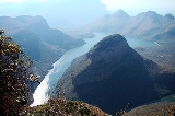
The Blyde River Canyon is a significant natural feature of South Africa
, located in Mpumalanga
, and forming the northern part of the Drakensberg
escarpment
. It is 16 miles (26 km) in length and is, on average, around 2500 feet (762 m) deep. The Dam
itself, when full, is at an altitude of 665m (2182 feet). The Canyon consists mostly of red sandstone
. The highest point of the canyon, Mariepskop, is 6378 feet (1,944 m) feet above sea level
, whilst its lowest point where the river leaves the canyon is slightly less than 1840 feet (561 m) above sea level. This means that by some measure the Canyon is over 4500 feet (1,372 m) deep.
canyon
s world-wide, Blyde River Canyon is one of the largest canyons on Earth, and it may be the largest 'green canyon' due to its lush subtropical foliage. It has some of the deepest precipitious cliffs of any canyon on the planet. It is the second largest canyon in Africa
, after the Fish River Canyon
, and is known as one of the great wonders of nature on the continent.
Possibly the best view in the whole of the Blyde River Canyon is of the "Three Rondavels", huge, round rocks, thought to be reminiscent of the houses or huts of the indigenous people, known as rondavels
. This canyon is part of the Panorama route. This route starts at the town Graskop
and includes God's Window, the Pinnacle and Bourke's Luck Potholes.
 Blyde means "glad" or "happy" in Dutch, a name derived from a voortrekkers' expedition. The 'happy river' was thus named in 1844, when Hendrik Potgieter
and others returned safely from Delagoa Bay
to the rest of their party of trekkers who had considered them dead. While still under this misapprehension they had named the nearby river where they had been encamped, Treurrivier, or 'mourning river'.
as well as species such as the Cape Vulture, Black Eagle, Crowned Eagle, African Fish Eagle, Gymnogene, Jackal Buzzard, Whitebacked Vulture, Bald Ibis, African Finfoot, Knysna Lourie, Purple-crested Lourie, Gurney's Sugarbird, Malachite Sunbird, Cinnamon Dove, Emerald Cuckoo, Red-backed Mannikin, Golden-tailed Woodpecker, Olive Bush Shrike, Green Twinspot, Taita Falcons (very rarely sighted, a breeding pair lives in the nearby Abel Erasmus pass), Cape Eagle Owl, White-faced Owl, Wood Owl, Peregrine Falcon, Black-breasted Snake Eagle, Wahlberg's Eagle, Long-crested Eagle, Jackal Buzzard, Lanner Falcon, Red-breasted Sparrowhawk, Rock Kestrel and others.
 At 200 metres (656.2 ft), the Kadishi Tufa
waterfall is the second tallest tufa
waterfall on earth. A tufa
waterfall is formed when water running over dolomite rock absorbs calcium, and deposits rock formations more rapidly than they erode the surrounding rock. In the case of the Kadishi Tufa
fall, the formation that has been produced strikingly resembles a face which is crying profusely, and is thus sometimes known as 'the weeping face of nature'.
escarpment
is a very popular tourist region with a well-developed tourism industry supported by good public infrastructure.
South Africa
The Republic of South Africa is a country in southern Africa. Located at the southern tip of Africa, it is divided into nine provinces, with of coastline on the Atlantic and Indian oceans...
, located in Mpumalanga
Mpumalanga
Mpumalanga , is a province of South Africa. The name means east or literally "the place where the sun rises" in Swazi, Xhosa, Ndebele and Zulu. Mpumalanga lies in eastern South Africa, north of KwaZulu-Natal and bordering Swaziland and Mozambique. It constitutes 6.5% of South Africa's land area...
, and forming the northern part of the Drakensberg
Drakensberg
The Drakensberg is the highest mountain range in Southern Africa, rising to in height. In Zulu, it is referred to as uKhahlamba , and in Sesotho as Maluti...
escarpment
Escarpment
An escarpment is a steep slope or long cliff that occurs from erosion or faulting and separates two relatively level areas of differing elevations.-Description and variants:...
. It is 16 miles (26 km) in length and is, on average, around 2500 feet (762 m) deep. The Dam
BlydeRivierpoort Dam
BlydeRivierpoort Dam is dam on the Blyde River, near Hoedspruit, Mpumalanga, South Africa. It was established in 1974.- References :* from the Department of Water Affairs and Forestry...
itself, when full, is at an altitude of 665m (2182 feet). The Canyon consists mostly of red sandstone
Sandstone
Sandstone is a sedimentary rock composed mainly of sand-sized minerals or rock grains.Most sandstone is composed of quartz and/or feldspar because these are the most common minerals in the Earth's crust. Like sand, sandstone may be any colour, but the most common colours are tan, brown, yellow,...
. The highest point of the canyon, Mariepskop, is 6378 feet (1,944 m) feet above sea level
Above mean sea level
The term above mean sea level refers to the elevation or altitude of any object, relative to the average sea level datum. AMSL is used extensively in radio by engineers to determine the coverage area a station will be able to reach...
, whilst its lowest point where the river leaves the canyon is slightly less than 1840 feet (561 m) above sea level. This means that by some measure the Canyon is over 4500 feet (1,372 m) deep.
canyon
Canyon
A canyon or gorge is a deep ravine between cliffs often carved from the landscape by a river. Rivers have a natural tendency to reach a baseline elevation, which is the same elevation as the body of water it will eventually drain into. This forms a canyon. Most canyons were formed by a process of...
s world-wide, Blyde River Canyon is one of the largest canyons on Earth, and it may be the largest 'green canyon' due to its lush subtropical foliage. It has some of the deepest precipitious cliffs of any canyon on the planet. It is the second largest canyon in Africa
Africa
Africa is the world's second largest and second most populous continent, after Asia. At about 30.2 million km² including adjacent islands, it covers 6% of the Earth's total surface area and 20.4% of the total land area...
, after the Fish River Canyon
Fish River Canyon
The Fish River Canyon is located in the south of Namibia. It is the second largest canyon in the world and the largest in Africa, as well as the second most visited tourist attraction in Namibia. It features a gigantic ravine, in total about long, up to 27 km wide and in places almost 550 metres...
, and is known as one of the great wonders of nature on the continent.
Possibly the best view in the whole of the Blyde River Canyon is of the "Three Rondavels", huge, round rocks, thought to be reminiscent of the houses or huts of the indigenous people, known as rondavels
Rondavel
A rondavel is a westernised version of the African-style hut.The rondavel is usually round or oval in shape and is traditionally made with materials that can be locally found in raw form. Its walls are often constructed from stones. The mortar may consist of sand, soil, or combinations of these,...
. This canyon is part of the Panorama route. This route starts at the town Graskop
Graskop
Graskop is a small town in Mpumalanga province, South Africa. It was set up in the 1880s as a gold mining camp but it now serves as a timber industry and milling centre. The name is Afrikaans for grassy peak. “God’s Window”, a breathtaking view from the escarpment of the Lowveld below, is located...
and includes God's Window, the Pinnacle and Bourke's Luck Potholes.
Name
Andries Hendrik Potgieter
Andries Hendrik Potgieter, known as Hendrik Potgieter was a Voortrekker leader. He served as the first head of state of Potchefstroom from 1840 and 1845 and also as the first head of state of Zoutpansberg from 1845 to 1852.Potgieter was born in the Tarkastad district of the Cape Colony, the second...
and others returned safely from Delagoa Bay
Maputo Bay
Maputo Bay , formerly Delagoa Bay, Baía da Lagoa is an inlet of the Indian Ocean on the coast of Mozambique, between 25° 40' and 26° 20' S, with a length from north to south of over 90 km long and 32 km wide....
to the rest of their party of trekkers who had considered them dead. While still under this misapprehension they had named the nearby river where they had been encamped, Treurrivier, or 'mourning river'.
Fauna and Flora
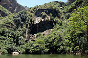
The Blyde River canyon supports large diversity of life, including numerous fish and antelope species as well as Hippos and Crocodiles, and every primate species that may be seen in South Africa (including both Greater and Lesser Bush Babies, Vervet Monkeys and Samango Monkeys). The diversity of birdlife is similarly high, including the beautiful and much sought Narina TrogonNarina Trogon
The Narina Trogon, Apaloderma narina, is a medium-sized , largely green forest bird in the Trogonidae family, the most widespread and catholic in habitat choice of three Apaloderma trogons...
as well as species such as the Cape Vulture, Black Eagle, Crowned Eagle, African Fish Eagle, Gymnogene, Jackal Buzzard, Whitebacked Vulture, Bald Ibis, African Finfoot, Knysna Lourie, Purple-crested Lourie, Gurney's Sugarbird, Malachite Sunbird, Cinnamon Dove, Emerald Cuckoo, Red-backed Mannikin, Golden-tailed Woodpecker, Olive Bush Shrike, Green Twinspot, Taita Falcons (very rarely sighted, a breeding pair lives in the nearby Abel Erasmus pass), Cape Eagle Owl, White-faced Owl, Wood Owl, Peregrine Falcon, Black-breasted Snake Eagle, Wahlberg's Eagle, Long-crested Eagle, Jackal Buzzard, Lanner Falcon, Red-breasted Sparrowhawk, Rock Kestrel and others.
Kadishi waterfall
Tufa
Tufa is a variety of limestone, formed by the precipitation of carbonate minerals from ambient temperature water bodies. Geothermally heated hot-springs sometimes produce similar carbonate deposits known as travertine...
waterfall is the second tallest tufa
Tufa
Tufa is a variety of limestone, formed by the precipitation of carbonate minerals from ambient temperature water bodies. Geothermally heated hot-springs sometimes produce similar carbonate deposits known as travertine...
waterfall on earth. A tufa
Tufa
Tufa is a variety of limestone, formed by the precipitation of carbonate minerals from ambient temperature water bodies. Geothermally heated hot-springs sometimes produce similar carbonate deposits known as travertine...
waterfall is formed when water running over dolomite rock absorbs calcium, and deposits rock formations more rapidly than they erode the surrounding rock. In the case of the Kadishi Tufa
Tufa
Tufa is a variety of limestone, formed by the precipitation of carbonate minerals from ambient temperature water bodies. Geothermally heated hot-springs sometimes produce similar carbonate deposits known as travertine...
fall, the formation that has been produced strikingly resembles a face which is crying profusely, and is thus sometimes known as 'the weeping face of nature'.
Tourism
The Canyon and the surrounding DrakensbergDrakensberg
The Drakensberg is the highest mountain range in Southern Africa, rising to in height. In Zulu, it is referred to as uKhahlamba , and in Sesotho as Maluti...
escarpment
Escarpment
An escarpment is a steep slope or long cliff that occurs from erosion or faulting and separates two relatively level areas of differing elevations.-Description and variants:...
is a very popular tourist region with a well-developed tourism industry supported by good public infrastructure.