
Willamette River
Encyclopedia
The Willamette River is a major tributary
of the Columbia River
, accounting for 12 to 15 percent of the Columbia's flow. The Willamette's main stem
is 187 miles (300.9 km) long, lying entirely in northwestern Oregon
in the United States
. Flowing northward between the Oregon Coast Range
and the Cascade Range
, the river and its tributaries form the Willamette Valley
, a basin that contains two-thirds of Oregon's population, including the state capital, Salem
, and the state's largest city, Portland
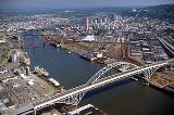
. Portland surrounds the Willamette's mouth
at the Columbia.
Originally created by plate tectonics
about 35 million years ago and subsequently altered by volcanism
and erosion, the river's drainage basin
was significantly modified by the Missoula Floods
at the end of the most recent ice age. Humans began living in the watershed over 10,000 years ago. There were once many tribal villages along the lower river and in the area around its mouth on the Columbia. Indigenous peoples lived throughout the upper reaches of the basin as well.
Rich with sediments deposited by flooding and fed by prolific rainfall on the western side of the Cascades, the Willamette Valley is one of the most fertile agricultural regions in North America
, and was thus the destination of many 19th-century pioneers traveling west along the Oregon Trail
. The river was an important transportation route during this time
, although Willamette Falls
, just upstream from Portland, was a major barrier to boat traffic. In the 21st century, major highways follow the river and roads cross it on more than 50 bridges.
Since 1900, more than 15 large dams and many smaller ones have been built in the Willamette's drainage basin, and 13 of them are managed by the U.S. Army Corps of Engineers
(USACE). The dams are used primarily to produce hydroelectricity
, to store water for irrigation
, and to divert water into deeper, narrower channels in order to prevent flooding. The river and its tributaries support 60 fish species, including many species of salmon
and trout
; this is despite the dams, other alterations, and pollution (especially on the river's lower reaches). Part of the Willamette Floodplain
was established as a National Natural Landmark
in 1987 and the river was named as one of 14 American Heritage Rivers
in 1998.
, and Springfield
. Formed by the confluence of the Middle Fork Willamette River
and the Coast Fork Willamette River
near Springfield, the main stem
Willamette meanders generally north for 187 miles (300.9 km) to the Columbia River
. The river's two most significant course deviations occur at Newberg
, where it turns sharply east, and about 18 miles (29 km) downstream from Newberg, where it turns north again. Near its mouth north of downtown Portland
, the river splits into two channels that flow around Sauvie Island
. Used for navigation purposes, these channels are managed by the U.S. federal government
. The main channel, which is 40 feet (12.2 m) deep and varies in width from 600 to 1900 ft (182.9 to 579.1 m) (although the river broadens to 2000 feet (609.6 m) in some of its lower reaches), enters the Columbia about 101 miles (162.5 km) from the larger river's mouth on the Pacific Ocean
. The channel forms the primary navigational conduit for Portland's harbor and riverside industrial areas. The smaller Multnomah Channel
, a distributary
, is 21 miles (33.8 km) long, about 600 feet (182.9 m) wide, and 40 feet (12.2 m) deep. It ends about 14.5 miles (23.3 km) further downstream on the Columbia, near St. Helens
in Columbia County
.
Proposals have been made for deepening the Multnomah Channel to 43 feet (13.1 m) in conjunction with roughly 103.5 miles (166.6 km) of tandem-maintained navigation on the Columbia River. Between the 1850s and the 1960s, channel-straightening and flood control projects, as well as agricultural and urban encroachment, cut the length of the river between the McKenzie River confluence and Harrisburg by 65 percent. Similarly, the river was shortened by 40 percent in the stretch between Harrisburg and Albany.
Interstate 5
and U.S. Route 99
are the two major highways that follow the river for its entire length. Communities along the main stem include Springfield and Eugene in Lane County
; Harrisburg
in Linn County
; Corvallis
in Benton County
; Albany
in Linn and Benton counties; Salem
in Marion County
; Newberg in Yamhill County
; Oregon City
, West Linn
, Milwaukie
, and Lake Oswego
in Clackamas County
; and Portland in Multnomah and Washington
counties. Significant tributaries from source to mouth include the Middle and Coast forks and the McKenzie
, Long Tom
, Marys
, Calapooia
, Santiam
, Luckiamute
, Yamhill
, Molalla
, Tualatin
, and Clackamas
rivers.
Beginning at 438 feet (133.5 m) above sea level, the main stem descends 428 feet (130.5 m) between source and mouth, or about 2.3 feet per mile (1.1 m per km). The gradient is slightly steeper from the source to Albany than it is from Albany to Oregon City. At Willamette Falls
, between West Linn and Oregon City, the river plunges about 40 feet (12.2 m). For the rest of its course, the river is extremely low-gradient and is affected by Pacific Ocean tidal effects from the Columbia. The main stem of the Willamette varies in width from about 330 to 660 ft (100.6 to 201.2 m).
 The U.S. Geological Survey
(USGS) operates four stream gauge
s along the river, at Harrisburg, Albany, Salem, and Portland. The average discharge at the lowermost gauge, near the Morrison Bridge in Portland, was 32950 cuft/s between 1972 and 2009. Located at river mile
(RM) 12.8 or river kilometer (RK) 20.6, the gauge measures the flow from an area of 11200 square miles (29,007.9 km²), roughly 97 percent of the Willamette basin. The highest flow recorded at this station was 420000 cuft/s on February 9, 1996, during the Willamette Valley Flood of 1996
, and the minimum was 4200 cuft/s on July 10, 1978. The highest recorded flow of 635000 cuft/s for the Willamette at a different gauge in Portland occurred during a flood in 1861
. This and many other large flows preceded the Flood Control Act of 1936
and dam construction on the Willamette's major tributaries.
The river below Willamette Falls, 26.5 miles (42.6 km) from the mouth, is affected by semidiurnal tides
, and gauges have detected reverse flows (backwards river flows) upstream from Ross Island
at RM 15 (RK 24). The National Weather Service
issues tide forecasts for the river at the Morrison Bridge
.
and volcanism
and was altered by erosion and sedimentation, including some related to enormous glacial floods as recent as 13,000 years ago. The initial trough-like configuration was created about 35 million years ago as a forearc
basin while the Pacific Plate
subducted
beneath the North American Plate
. Marine deposits on top of older volcanics underlie the valley, which was initially part of the continental shelf
, rather than a separate inland sea. About 20 to 16 million years ago, uplift formed the Coast Range and separated the basin from the Pacific Ocean.
Basalt
s of the Columbia River Basalt Group
, from eruptions in eastern Oregon
, flowed across large parts of the northern half of the basin about 15 million years ago. They covered the Tualatin Mountains
(West Hills), most of the Tualatin Valley
, and the slopes of hills further south, with up to 1000 feet (304.8 m) of lava
. Later depositions covered the basalt with up to 1000 feet (304.8 m) of silt in the Portland and Tualatin basins. During the Pleistocene
, beginning roughly 2.5 million years ago, volcanic activity in the Cascades
combined with a cool, moist climate to produce further heavy sedimentation across the basin; braided river
s created alluvial fan
s spreading down from the east.
Between about 15,500 and 13,000 years ago, the Missoula Floods
—a series of large outpourings originating at Glacial Lake Missoula
in Montana—swept down the Columbia River and backfilled the Willamette watershed. Each flood produced "discharges that exceeded the annual discharge of all the present-day rivers of the world combined". Filling the Willamette basin to depths of 400 feet (121.9 m) in the Portland region, each flood created a temporary lake, Lake Allison
, that stretched from Lake Oswego to near Eugene. The ancestral Tualatin Valley, part of the Willamette basin, flooded as well; water depths ranged from 200 feet (61 m) at Lake Oswego to 100 feet (30.5 m) as far upstream (west) as Forest Grove
. Flood deposits of silt and clay, ranging in thickness from 115 feet (35.1 m) in the north to about 15 feet (4.6 m) in the south, settled from this muddy water to form today's valley floor. The floods carried Montana icebergs well into the basin, where they melted and dropped glacial erratic
s on the land's surface. These rocks, composed of granite and other materials common to central Montana but not to the Willamette Valley
, include more than 40 boulders, each at least 3 foot (0.9144 m) in diameter. Before being partly chipped away and removed, the largest of these originally weighed about 160 short tons (145.1 MT).
The northern part of the watershed is underlain by a network of faults capable of producing earthquakes at any time, and many small quakes have been recorded in the basin since the mid-19th century. In 1993, the Scotts Mills earthquake—the largest recent earthquake in the valley, measuring 5.6 on the Richter scale
—was centered near Scotts Mills
, about 34 miles (54.7 km) south of Portland. It caused $30 million in damage, including harm to the Oregon State Capitol
in Salem. Evidence suggests that massive quakes of 8 or more on the Richter scale have occurred historically in the Cascadia subduction zone
off the Oregon coast, most recently in 1700 CE, and that others as strong as 9 on the Richter scale occur every 500 to 800 years. The basin's high population density, its nearness to this subduction zone, and its loose soils, which tend to amplify shaking, make the Willamette Valley especially vulnerable to damage from strong earthquakes.
in the Cascade Range to 10 feet (3 m) at the mouth on the Columbia River. Watersheds bordering the Willamette River basin are those of the Little Deschutes River to the southeast, the Deschutes River to the east, and the Sandy River
to the northeast; the North Umpqua
and Umpqua
rivers to the south; coastal rivers including (from south to north) the Siuslaw
, the Alsea
, the Yaquina
, the Siletz
, the Nestucca
, the Trask
, and the Wilson
to the west; the Nehalem
and the Clatskanie
to the northwest, and the Columbia River to the north.
About 2.5 million people lived in the Willamette River basin as of 2010, about 65 percent of the population of Oregon. As of 2009, the basin contained 20 of the 25 most populous cities in Oregon. These cities include Springfield, Eugene, Corvallis, Albany, Salem, Keizer, Newberg, Oregon City, West Linn, Milwaukie, Lake Oswego, and Portland. The largest is Portland, with more than 500,000 residents. Other cities in the watershed (but not on the main-stem river) with populations of 20,000 or more are Gresham, Hillsboro, Beaverton, Tigard, McMinnville, Tualatin, Woodburn
, and Forest Grove.
Sixty-four percent of the watershed is privately owned, while 36 percent is publicly owned. The U.S. Forest Service
manages 30 percent of the watershed, the U.S. Bureau of Land Management
5 percent, and the State of Oregon 1 percent. Sixty-eight percent of the watershed is forested; agriculture, concentrated in the Willamette Valley, makes up 19 percent, and urban areas cover 5 percent. More than 81000 miles (130,356.5 km) of roads criss-cross the watershed.
In 1987, the U.S. Secretary of the Interior
designated 713 acres (288.5 ha) of the watershed in Benton County as a National Natural Landmark
. This area is the Willamette Floodplain
, the largest remaining unplowed native grassland in the North Pacific geologic province, which encompasses most of the Pacific Northwest coast.
 For at least 10,000 years, a variety of indigenous peoples populated the Willamette Valley. These included the Kalapuya, the Chinook, and the Clackamas. The territory of the Clackamas encompassed the northeastern portion of the basin, including the Clackamas River (with which their name is shared). Although it is unclear exactly when, the territory of the Chinook once extended across the northern part of the watershed, through the Columbia River valley. Indigenous peoples of the Willamette Valley were further divided into groups including the Yamhill, Atfalati
(Tualatin), Molala, Santiam, Chuchsney-Tufti, Muddy Creek, Long Tom, Yoncalla, Siuslaw, Calapooia, Chepenafa and Luckiamute, many of which were part of the larger Kalapuya group. The name Willamette is of indigenous origin, deriving from the French pronunciation of the name of a Clackamas Native American village. However, Native American languages in Oregon were very similar, so the name may also be derived from Kalapuya dialects.
Around the year 1850, the Kalapuya numbered between 2,000 and 3,000 and were distributed among several groups. These figures are only speculative; there may have been as few as eight subgroups or as many as 16. In that time period, the Clackamas' tribal population was roughly 1,800. The U.S. Census Bureau
estimated that the Chinook population was nearly 5,000, though not all of the Chinook lived on the Willamette. The Chinook territory encompassed the lower Columbia River valley and significant stretches of the Pacific coast on both the north and the south side of the Columbia's mouth. At times, however, the Chinook territory extended even farther south in the Willamette Valley. The total native population was estimated at about 15,000.
The indigenous peoples of the Willamette River practiced a variety of life ways. Those on the lower river, slightly closer to the coast, often relied on fishing as their primary economic mainstay. Salmon was the most important fish to Willamette River tribes as well as to the Native Americans of the Columbia River, where white traders traded fish with the Native Americans. Upper-river tribes caught steelhead and salmon, often by building weir
s across tributary
streams. Tribes of the northern Willamette Valley practiced a generally settled lifestyle. The Chinooks lived in great wooden lodges, practiced slavery
, and had a well-defined caste
system. People of the south were more nomadic, traveling from place to place with the seasons. They were known for the controlled burning of woodlands to create meadows for hunting and plant gathering (especially camas
).
, led by George Vancouver
. From the 18th to the mid-19th centuries, much of the Pacific Northwest
and most of its rivers were involved in the fur trade
, in which fur trappers (mostly French-Canadians working for the Hudson's Bay Company
and the North West Company
, which later merged) hunted for beaver
and sea otter
on rivers, streams, and coastlines. The pelts of these animals commanded substantial prices in either the United States, Canada or eastern Asia, because of their "thick, luxurious and water-repellent" qualities.
Fur traders heavily exploited the Willamette River and its tributaries. During this period, the Siskiyou Trail
(or California-Oregon Trail) was created. This trading path, over 600 miles (965.6 km) long, stretched from the mouth of the Willamette River near present-day Portland south through the Willamette Valley, crossing the Cascades and the Siskiyou Mountains
, and south through the Sacramento Valley
to San Francisco, California
.
traveled thousands of miles across central North America
in an attempt to map and explore the Louisiana Territory
of the United States and the Oregon Country
, which were then occupied mainly by Native Americans and settlers from Great Britain
. As the expedition traveled down and back up the Columbia River, it missed the mouth of the Willamette, one of the Columbia's largest tributaries. It was only after receiving directions from natives along the Sandy River that the explorers learned about their oversight. William Clark returned down the Columbia and entered the Willamette River in April 1806. The United States Exploring Expedition
passed through the Willamette Valley in 1841 while traveling along the Siskiyou Trail. The expedition members noted extensive salmon fishing by natives at Willamette Falls, much like that at Celilo Falls
on the Columbia River.
In the middle part of the 19th century, the Willamette Valley's fertile soils, pleasant climate, and abundant water attracted thousands of settlers from the eastern United States
, mainly the Upland South
borderlands of Missouri, Iowa, and the Ohio Valley. Many of these emigrants followed the Oregon Trail
, a 2170 miles (3,492.3 km) trail across western North America that began at Independence, Missouri
, and ended at various locations near the mouth of the Willamette River. Although people had been traveling to Oregon since 1836, large-scale migration did not begin until 1843, when nearly 1,000 pioneers headed westward. Over the next 25 years, some 500,000 settlers traveled the Oregon Trail, braving the rapids of the Snake
and Columbia Rivers to reach the Willamette Valley.
Starting in the 1820s, Oregon City developed near Willamette Falls. It was incorporated in 1844, becoming the first city west of the Rocky Mountains
to have that distinction. John McLoughlin
, a Hudson's Bay Company (HBC) official, was one of the major contributors to the founding of the town in 1829. McLoughlin attempted to persuade the British government (which still held sway over the area) to allow American settlers to live on the land, and provided significant help to American colonization of the area, all against the HBC's orders. Oregon City prospered because of the paper mill
s that were run by the water power of Willamette Falls, but the falls formed an impassable barrier to river navigation. Linn City
(originally Robins Nest) was established across the Willamette from Oregon City.
After Portland was incorporated in 1851, quickly growing into Oregon's largest city, Oregon City gradually lost its importance as the economic and political center of the Willamette Valley. Beginning in the 1850s, steamboat
s began to ply the Willamette, despite the fact that they could not pass Willamette Falls. As a result, navigation on the Willamette River was divided into two stretches: the 27 miles (43.5 km) lower stretch from Portland to Oregon City—which allowed connection with the rest of the Columbia River system—and the upper reach, which encompassed most of the Willamette's length. Any boats whose owners found it absolutely necessary to get past the falls had to be portage
d. This created strong competition among steam companies and portage companies. In 1873, the construction of the Willamette Falls Locks
bypassed the falls and allowed easy navigation between the upper and lower river. Each lock chamber measured 210 feet (64 m) long and 40 feet (12.2 m) wide, and the canal was originally operated manually before it switched to electrical power. Today, the lock system is little used.
As commerce and industry flourished on the lower river, most of the original settlers acquired farms in the upper Willamette Valley. By the late 1850s, farmers had begun to grow crops on most of the available fertile land. The settlers increasingly encroached on Native American lands. Skirmishes between natives and settlers in the Umpqua and Rogue
valleys to the southwest of the Willamette River led the Oregon state government
to remove the natives by military force. They were first led off their traditional lands to the Willamette Valley, but soon were marched to the Coast Indian Reservation
. In 1855, Joel Palmer
, an Oregon legislator, negotiated a treaty with the Willamette Valley tribes, who, although unhappy with the treaty, ceded their lands to non-natives. The natives were then relocated by the government to a part of the Coast Reservation that later became the Grande Ronde Reservation.
Between 1879 and 1885, the Willamette River was charted by Cleveland S. Rockwell
, a topographical engineer and cartographer for the U.S. Coast and Geodetic Survey
. Rockwell surveyed the lower Willamette from the foot of Ross Island
through Portland to the Columbia River and then downstream on the Columbia to Bachelor Island
. Rockwell's survey was extremely detailed, including 17,782 hydrographic soundings. His work helped open the port of Portland to commerce.
In the second half of the 19th century, the USACE began work on digging deep channels and building dams and levees in the Willamette's watershed and elsewhere in Oregon. This cleared the way for lumber, minerals, and agricultural products to arrive in Portland and feed its growing economy. Steamboats could more easily navigate up and down rivers, although the USACE had to build locks to allow ships to pass rapids or dams. The channels near the Willamette's mouth provided a way for ships heading up the Columbia to reach settlements in the Willamette Valley. Lumber from the Willamette's watershed could be transported via railroads connecting lumber mills through the Coast Range to jetties on bays and river mouths on the Pacific coast.
With development in and near the river came increased pollution. By the late 1930s, efforts to stem the pollution led to formation of a state sanitary board to oversee modest cleanup efforts. In the 1960s, Oregon Governor Tom McCall
led a push for stronger pollution controls on the Willamette. To enhance historical, natural, and recreational values along the river, the Oregon State Legislature established the Willamette Greenway
program in 1967. Through it, state and local governments cooperated in creating or improving a system of parks, trails, and wildlife refuges along the river. In 1998, the Willamette became one of 14 rivers designated an American Heritage River by former U.S. President Bill Clinton
. By 2007 the Greenway had grown to include more than 170 separate land parcels, including 10 state parks. Public uses of the river and land along its shores include camping, swimming, fishing, boating, hiking, bicycling, and wildlife viewing.
A 1991 agreement between the City of Portland and the State of Oregon to dramatically reduce combined sewer overflows (CSOs), led to Portland's "Big Pipe Project". The long-term project has been separating the city's sanitary sewer lines from storm-water inputs that sometimes overwhelm the combined system during heavy rains. When that occurs, some of the raw sewage in the system flows into the river instead of into the city's wastewater treatment plant. The City of Portland predicts that Big Pipe and related work will reduce CSO volume on the lower river by more than 94 percent by the end of 2011.
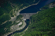 There are more than 15 major dams on the Willamette's tributaries as well as a complex series of levees, dikes, and channels to control the river's flow. The only dam on the Willamette's main stem, however, is the Willamette Falls Dam, a low weir
-type structure at Willamette Falls that diverts water into the headraces of the adjacent mills and a power plant. The dams on the Willamette's major tributaries are primarily large flood-control, water storage, and power-generating dams. Thirteen of these dams were built by the U.S. Army Corps of Engineers
(USACE), and 11 of them produce hydropower. Most of the other ones are owned by state or local interests.
On the main stem, numerous flow regulation structures force the river into a narrower and deeper channel to facilitate navigation and flood control. Flood-control dams operated by the USACE are estimated to hold up to 27 percent of the Willamette's runoff. They are used to regulate river flows so as to cut peaks off floods and increase low flows in late summer and autumn.
Large dams and their reservoirs include Hills Creek, Lookout Point
, Dexter, and Fall Creek on the Middle Fork and its tributaries; Cottage Grove on the Coast Fork; Cougar
on the South Fork McKenzie; Fern Ridge
on the Long Tom River; Green Peter
, Foster
, Detroit
, and Big Cliff on various forks of the Santiam; and North Fork, Faraday, Oak Grove
, and Timothy
on the Clackamas and its forks. Detroit Dam on the North Santiam River
, by far the largest, is 463 feet (141.1 m) high and stores 455000 acre.ft of water. USACE dam facilities in the basin are collectively known as the Willamette River Basin Project.
 The 50 or so crossings of the Willamette River include many historic structures, such as the Van Buren Street Bridge
, a swing bridge
. Built in 1913, it carries Oregon Route 34 (Corvallis–Lebanon Highway) over the river upstream of RM 131 (RK 211) in Corvallis. The machinery to operate the swing span was removed in the 1950s. The Oregon City Bridge
, built in 1922, replaced a suspension span
constructed at the site in 1888. It carries Oregon Route 43 over the river at about RM 26 (RK 42) between Oregon City and West Linn
.
The Ross Island Bridge
, which carries U.S. Route 26
(Mount Hood Highway
) over the river at RM 14 (RK 23), is the furthest upstream of 10 highway bridges that cross the Willamette River in Portland's central business district. The 3700 feet (1,127.8 m) bridge is the only cantilevered deck truss
in Oregon. The oldest remaining highway structure over the Willamette is the 1910-built Hawthorne Bridge, located slightly downstream from the Ross Island Bridge.
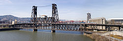 Another historic structure, the Steel Bridge
, further downstream, was "the largest telescoping bridge in the world at the time of its opening" in 1912. It carries trains on its lower deck, MAX (Metropolitan Area Express) light-rail trains and motorized vehicles on its upper deck, and foot and bicycle traffic on a cantilevered walkway attached to the lower deck. When small ships must pass under the bridge, its double vertical-lift span can raise a lower railway deck without disturbing traffic on the upper deck. Operators can raise both decks as high as 163 feet (49.7 m) above the water. The Steel Bridge is "believed to be the world's only double-lift span that can raise its lower deck independently of the upper deck."
The Broadway Bridge
, slightly downstream of the Steel Bridge, was the world's longest double-leaf bascule
drawbridge at the time of its construction in 1913. Further downstream, the St. Johns Bridge
, a steel suspension bridge built in 1931, replaced the last of the Willamette River ferries
in Portland. At about RM 6 (RK 10), it carries U.S. Route 30 Bypass
.
, as it is sometimes called, was massively destructive to human development because most of that development was located in the river's floodplain. Floodplain locations offer easy access to river transportation and the best soils for farming. The 1861 flood peaked at 635000 cuft/s—which was more than the flow of the Mississippi River
—and inundated some 353000 acres (1,428.5 km²) of land.
In the summer of 1866, the Willamette was measured at 21 feet (6.4 m) above the "low water mark," and there were more flooding worries. This raised the level of the Columbia River and nearly flooded The Dalles
, a city on the Columbia.
The floods returned in early 1890, when the river first rose very quickly and then fell very quickly. Portland's main street was completely submerged. Communication over the Cascades was cut off, and many rail lines were forced to shut down. In 1894, another major flood occurred on the Willamette, and although it too caused huge damage, it was not quite as large as that of 1861.
In the 1940s the Willamette once again flooded its valley. It destroyed five bridges in Lane County in December 1942, caused seven deaths in Portland and forced people in Eugene to evacuate in January 1943, caused minor flooding in Corvallis in November 1946, and nearly flooded parts of Salem in December 1948.
Although the Willamette was, by mid-century, heavily engineered and controlled by a complex system of dams, channels, and barriers, it experienced severe floods through the end of the century. Storms caused a major flood
that swelled the Willamette and other rivers in the Pacific Northwest from December 1964 through January 1965, submerging nearly 153000 acres (619.2 km²) of land. Before dawn on December 21, 1964, the Willamette reached 29.4 feet (9 m), which was higher than the Portland seawall. By this time, about 15 people had died as a result of the flooding and about 8,000 Oregonians had been forced to evacuate their homes in search of other shelter.
On December 24, President Lyndon B. Johnson
ordered federal aid for the flooded areas. Meanwhile, the Willamette continued to rise. In the next couple of days, the river receded, but on December 27, it was at 29.8 feet (9.1 m), which was still nearly 12 feet (3.7 m) above the flood stage. The Willamette continued to pose flooding threats through January 1965, and more stormy weather occurred along the Pacific Coast.
Very heavy warm rains driven by a subtropical jet stream
fell on a high, water-heavy snowpack in the Willamette watershed
in February 1996. These conditions, similar to those that caused the 1861 flood, caused some of the costliest flooding in the river's recorded history
. An Associated Press
journalist wrote, "The river crested at one town after another—at Corvallis 3½ feet above flood stage, Oregon City 18 feet above, Portland 10.5 feet above—much like a meal moving through a boa constrictor." The flood interrupted the progress of Oregon's growing economy. However, the inundated acreage was even smaller than in 1964—only about 117000 acres (473.5 km²).
In the wake of the flood in April 1996, about 450 concrete flood-protection walls that had been built in Portland during the flood were removed. Each wall weighed roughly 5500 pounds (2,494.8 kg). In October, however, a new wall was built near Portland, costing about $300,000. It featured 6.35 millimetre (0.25 in) removable steel plates designed to prevent future flooding.
 Since as early as 1869, with the introduction of a federally-funded "snag puller" designed to keep the waterway clear, human habitation has affected the ecology of the river basin. The construction of large federal dams on the Willamette's tributaries between 1941 and 1969 damaged the spawning grounds for spring Chinook salmon and steelhead trout. Domestic and industrial waste from the cities built up along the river, "essentially turning the main-stem river into an open sewer by the 1920s."
A 1927 Portland City Club report labeled the waterway "filthy and ugly," and identified the City of Portland as the worst offender. The Oregon Anti-Stream Pollution League brought a pollution-abatement measure before the 39th Oregon Legislative Assembly in 1937. The bill passed, but Governor Charles Martin vetoed it. The Izaak Walton League and the Oregon Wildlife Federation countered the governor's veto with a ballot initiative, which passed in November 1938.
Shortly after he was elected in 1966, Governor Tom McCall
ordered water quality tests on the Willamette, conducted his own research on the water quality, and became head of the Oregon Sanitary Authority. McCall learned that the river was heavily polluted in Portland. In a television documentary, "Pollution in Paradise", he said that "the Willamette River was actually cleaner when the Oregon Sanitary Authority was created in 1938 than it was in 1962." He then discouraged tourism in the state and made it harder for companies to qualify for a permit to operate near the river. He also regulated how much those companies could pollute and closed plants that did not meet state pollution standards.
Despite earlier cleanup efforts, state studies in the 1990s identified a wide variety of pollutants in the river bottom, including heavy metals, polychlorinated biphenyl
s (PCBs), and pesticides along the lower 12 miles (19.3 km) of the river, in Portland. As a result, this section of the river was designated a Superfund
site in 2000, involving the U.S. Environmental Protection Agency
(EPA) in cleanup of the river bottom. The initial cleanup is focused on the portion between Swan Island and Sauvie Island
. Pollution is exacerbated by combined sewer overflows, which the city is greatly reducing through its Big Pipe Project. Further upstream, the pressing environmental issues have mainly been variations in pH and dissolved oxygen. The Willamette is nevertheless clean enough to be used by communities such as Tigard
for drinking water.
Since pollution concerns are primarily along the lower river, the Willamette in general scores relatively high on the Oregon Water Quality Index (OWQI), which is compiled by the Oregon Department of Environmental Quality
(DEQ). The DEQ considers index scores of less than 60 to be very poor; the other categories are 60–79 (poor); 80–84 (fair); 85–89 (good), and 90–100 (excellent). The Willamette River's water quality is rated excellent near the source, though it gradually declines to fair near the mouth. Between 1998 and 2007, the average score for the upper Willamette at Springfield (RM 185, RK 298) was 93. At Salem (RM 84, RK 135), the score was 89, and good scores continued all the way to the Hawthorne Bridge in Portland (RM 13, RK 21) at 85. Scores were in the "fair" category further downstream; the least favorable reading was at the Swan Island Channel midpoint (RM 0.5, RK 0.8) at 81. By comparison, sites on the Winchuck River
, the Clackamas, and the North Santiam all scored 95, and a site at a pump station on Klamath Strait Drain between Upper Klamath Lake
and Lower Klamath Lake
recorded the lowest score in Oregon at 19.
 Over the past 150 years, a significant change for the Willamette River has been the loss of its floodplain forests, which covered an estimated 89 percent of a 400 feet (121.9 m) band along each river bank in 1850. By 1990 only 37 percent of this zone was forested; the rest had been converted to farm fields or cleared for urban or suburban uses. The remaining forests close to the river include large stands of black cottonwood
, Oregon ash, willow
, and bigleaf maple. The central valley—a former perennial grass prairie interspersed with oaks, ponderosa pines, and other trees—is devoted almost entirely to farming. Douglas fir, western hemlock, and western red cedar
dominate the forest on the Coast Range side of the basin. Forests to the east in the Cascade Range include Pacific silver fir as well as western hemlock and western red cedar.
Fish in the Willamette basin include 31 native species, among them cutthroat
, bull
, and rainbow
trout, several species of salmon
, sucker
, minnow
, sculpin
, and lamprey
, as well as sturgeon
, stickleback
, and others. Among the 29 non-native species in the basin, there are brook
, brown
, and lake
trout, largemouth
and smallmouth
bass, walleye
, carp
, bluegill
, and others. In addition to fish, the basin supports 18 species of amphibians, such as the Pacific giant salamander
. Beaver
and river otter are among 69 mammal species living in the watershed, also frequented by 154 bird species, such as the American Dipper
, Osprey
, and Harlequin Duck
. Garter snake
s are among the 15 species of reptiles found in the basin.
Species diversity is greatest along the lower river and its tributaries. Threatened, endangered, or sensitive species include spring Chinook salmon
, winter steelhead, Oregon chub
, chum salmon
, and Coho salmon
. In the central valley, there have been several projects that have restored and protected wetlands in order to provide and preserve habitat for Bald Eagle
s, Fender's blue butterfly
(of which 6,000 remain), Oregon chub, Bradshaw's desert parsley
, Willamette Daisy, and Kincaid's lupine
. In the early 21st century, osprey populations are increasing along the river, possibly because of a ban on the pesticide DDT
and on the birds' ability to use power poles for nesting. Beaver populations, presumed to be much lower than historic levels, are increasing throughout the basin.
Tributary
A tributary or affluent is a stream or river that flows into a main stem river or a lake. A tributary does not flow directly into a sea or ocean...
of the Columbia River
Columbia River
The Columbia River is the largest river in the Pacific Northwest region of North America. The river rises in the Rocky Mountains of British Columbia, Canada, flows northwest and then south into the U.S. state of Washington, then turns west to form most of the border between Washington and the state...
, accounting for 12 to 15 percent of the Columbia's flow. The Willamette's main stem
Main Stem
"Main Stem" is 1942 instrumental by Duke Ellington and His Famous Orchestra. Although recorded in 1942, the single would not be released until 1944 where it was Duke Ellington's last of four number one's on the Harlem Hit Parade. "Main Stem" would also peak at number twenty on the pop chart"Main...
is 187 miles (300.9 km) long, lying entirely in northwestern Oregon
Oregon
Oregon is a state in the Pacific Northwest region of the United States. It is located on the Pacific coast, with Washington to the north, California to the south, Nevada on the southeast and Idaho to the east. The Columbia and Snake rivers delineate much of Oregon's northern and eastern...
in the United States
United States
The United States of America is a federal constitutional republic comprising fifty states and a federal district...
. Flowing northward between the Oregon Coast Range
Oregon Coast Range
The Oregon Coast Range, often called simply the Coast Range and sometimes the Pacific Coast Range, is a mountain range, in the Pacific Coast Ranges physiographic region, in the U.S. state of Oregon along the Pacific Ocean...
and the Cascade Range
Cascade Range
The Cascade Range is a major mountain range of western North America, extending from southern British Columbia through Washington and Oregon to Northern California. It includes both non-volcanic mountains, such as the North Cascades, and the notable volcanoes known as the High Cascades...
, the river and its tributaries form the Willamette Valley
Willamette Valley
The Willamette Valley is the most populated region in the state of Oregon of the United States. Located in the state's northwest, the region is surrounded by tall mountain ranges to the east, west and south and the valley's floor is broad, flat and fertile because of Ice Age conditions...
, a basin that contains two-thirds of Oregon's population, including the state capital, Salem
Salem, Oregon
Salem is the capital of the U.S. state of Oregon, and the county seat of Marion County. It is located in the center of the Willamette Valley alongside the Willamette River, which runs north through the city. The river forms the boundary between Marion and Polk counties, and the city neighborhood...
, and the state's largest city, Portland
Portland, Oregon
Portland is a city located in the Pacific Northwest, near the confluence of the Willamette and Columbia rivers in the U.S. state of Oregon. As of the 2010 Census, it had a population of 583,776, making it the 29th most populous city in the United States...
. Portland surrounds the Willamette's mouth
River delta
A delta is a landform that is formed at the mouth of a river where that river flows into an ocean, sea, estuary, lake, reservoir, flat arid area, or another river. Deltas are formed from the deposition of the sediment carried by the river as the flow leaves the mouth of the river...
at the Columbia.
Originally created by plate tectonics
Plate tectonics
Plate tectonics is a scientific theory that describes the large scale motions of Earth's lithosphere...
about 35 million years ago and subsequently altered by volcanism
Volcanism
Volcanism is the phenomenon connected with volcanoes and volcanic activity. It includes all phenomena resulting from and causing magma within the crust or mantle of a planet to rise through the crust and form volcanic rocks on the surface....
and erosion, the river's drainage basin
Drainage basin
A drainage basin is an extent or an area of land where surface water from rain and melting snow or ice converges to a single point, usually the exit of the basin, where the waters join another waterbody, such as a river, lake, reservoir, estuary, wetland, sea, or ocean...
was significantly modified by the Missoula Floods
Missoula Floods
The Missoula Floods refer to the cataclysmic floods that swept periodically across eastern Washington and down the Columbia River Gorge at the end of the last ice age. The glacial flood events have been researched since the 1920s...
at the end of the most recent ice age. Humans began living in the watershed over 10,000 years ago. There were once many tribal villages along the lower river and in the area around its mouth on the Columbia. Indigenous peoples lived throughout the upper reaches of the basin as well.
Rich with sediments deposited by flooding and fed by prolific rainfall on the western side of the Cascades, the Willamette Valley is one of the most fertile agricultural regions in North America
North America
North America is a continent wholly within the Northern Hemisphere and almost wholly within the Western Hemisphere. It is also considered a northern subcontinent of the Americas...
, and was thus the destination of many 19th-century pioneers traveling west along the Oregon Trail
Oregon Trail
The Oregon Trail is a historic east-west wagon route that connected the Missouri River to valleys in Oregon and locations in between.After 1840 steam-powered riverboats and steamboats traversing up and down the Ohio, Mississippi and Missouri rivers sped settlement and development in the flat...
. The river was an important transportation route during this time
Oregon pioneer history
Oregon Pioneer History is the period in the history of the U.S. state of Oregon when pioneers and mountain men, primarily of European descent, traveled west across North America to explore and settle the lands west of the Rocky Mountains and north of California...
, although Willamette Falls
Willamette Falls
The Willamette Falls is a natural waterfall on the Willamette River between Oregon City and West Linn, Oregon, in the United States. It is the largest waterfall in the Pacific Northwest and the eighteenth largest in the world by water volume. Horseshoe in shape, it is wide and high with a flow...
, just upstream from Portland, was a major barrier to boat traffic. In the 21st century, major highways follow the river and roads cross it on more than 50 bridges.
Since 1900, more than 15 large dams and many smaller ones have been built in the Willamette's drainage basin, and 13 of them are managed by the U.S. Army Corps of Engineers
United States Army Corps of Engineers
The United States Army Corps of Engineers is a federal agency and a major Army command made up of some 38,000 civilian and military personnel, making it the world's largest public engineering, design and construction management agency...
(USACE). The dams are used primarily to produce hydroelectricity
Hydroelectricity
Hydroelectricity is the term referring to electricity generated by hydropower; the production of electrical power through the use of the gravitational force of falling or flowing water. It is the most widely used form of renewable energy...
, to store water for irrigation
Irrigation
Irrigation may be defined as the science of artificial application of water to the land or soil. It is used to assist in the growing of agricultural crops, maintenance of landscapes, and revegetation of disturbed soils in dry areas and during periods of inadequate rainfall...
, and to divert water into deeper, narrower channels in order to prevent flooding. The river and its tributaries support 60 fish species, including many species of salmon
Salmon
Salmon is the common name for several species of fish in the family Salmonidae. Several other fish in the same family are called trout; the difference is often said to be that salmon migrate and trout are resident, but this distinction does not strictly hold true...
and trout
Trout
Trout is the name for a number of species of freshwater and saltwater fish belonging to the Salmoninae subfamily of the family Salmonidae. Salmon belong to the same family as trout. Most salmon species spend almost all their lives in salt water...
; this is despite the dams, other alterations, and pollution (especially on the river's lower reaches). Part of the Willamette Floodplain
Willamette Floodplain
The Willamette Floodplain consists of of natural grassland that was made a National Natural Landmark near the Willamette River in May 1987. The floodplain is within the William L...
was established as a National Natural Landmark
National Natural Landmark
The National Natural Landmark program recognizes and encourages the conservation of outstanding examples of the natural history of the United States. It is the only natural areas program of national scope that identifies and recognizes the best examples of biological and geological features in...
in 1987 and the river was named as one of 14 American Heritage Rivers
American Heritage Rivers
American Heritage Rivers are designated by the United States Environmental Protection Agency to receive special attention to further three objectives: natural resource and environmental protection, economic revitalization, and historic and cultural preservation.The American Heritage Rivers...
in 1998.
Course
The upper tributaries of the Willamette originate in the mountains south and southeast of Eugene, OregonEugene, Oregon
Eugene is the second largest city in the U.S. state of Oregon and the seat of Lane County. It is located at the south end of the Willamette Valley, at the confluence of the McKenzie and Willamette rivers, about east of the Oregon Coast.As of the 2010 U.S...
, and Springfield
Springfield, Oregon
Springfield is a city in Lane County, Oregon, United States. Located in the Southern Willamette Valley, it is within the Eugene-Springfield Metropolitan Statistical Area. Separated from Eugene to the west, mainly by Interstate 5, Springfield is the second-most populous city in the metropolitan area...
. Formed by the confluence of the Middle Fork Willamette River
Middle Fork Willamette River
The Middle Fork Willamette River is one of several forks that unite to form the Willamette River in the western part of the U.S. state of Oregon...
and the Coast Fork Willamette River
Coast Fork Willamette River
The Coast Fork Willamette River is one of several forks that unite to form the Willamette River in western Oregon in the United States. It is about long, draining an area of the mountains at the south end of the Willamette Valley south of Eugene.-Course:...
near Springfield, the main stem
Main Stem
"Main Stem" is 1942 instrumental by Duke Ellington and His Famous Orchestra. Although recorded in 1942, the single would not be released until 1944 where it was Duke Ellington's last of four number one's on the Harlem Hit Parade. "Main Stem" would also peak at number twenty on the pop chart"Main...
Willamette meanders generally north for 187 miles (300.9 km) to the Columbia River
Columbia River
The Columbia River is the largest river in the Pacific Northwest region of North America. The river rises in the Rocky Mountains of British Columbia, Canada, flows northwest and then south into the U.S. state of Washington, then turns west to form most of the border between Washington and the state...
. The river's two most significant course deviations occur at Newberg
Newberg, Oregon
-Demographics:As of the census of 2000, there were 18,064 people, 6,099 households, and 4,348 families residing in the city. The population density was 3,599.4 people per square mile . There were 6,435 housing units at an average density of 1,282.2 per square mile...
, where it turns sharply east, and about 18 miles (29 km) downstream from Newberg, where it turns north again. Near its mouth north of downtown Portland
Portland, Oregon
Portland is a city located in the Pacific Northwest, near the confluence of the Willamette and Columbia rivers in the U.S. state of Oregon. As of the 2010 Census, it had a population of 583,776, making it the 29th most populous city in the United States...
, the river splits into two channels that flow around Sauvie Island
Sauvie Island
Sauvie Island, in the U.S. state of Oregon, originally Wapato Island or Wappatoo Island, is the largest island along the Columbia River, at 26,000 acres , and the largest river island in the United States...
. Used for navigation purposes, these channels are managed by the U.S. federal government
Federal government of the United States
The federal government of the United States is the national government of the constitutional republic of fifty states that is the United States of America. The federal government comprises three distinct branches of government: a legislative, an executive and a judiciary. These branches and...
. The main channel, which is 40 feet (12.2 m) deep and varies in width from 600 to 1900 ft (182.9 to 579.1 m) (although the river broadens to 2000 feet (609.6 m) in some of its lower reaches), enters the Columbia about 101 miles (162.5 km) from the larger river's mouth on the Pacific Ocean
Pacific Ocean
The Pacific Ocean is the largest of the Earth's oceanic divisions. It extends from the Arctic in the north to the Southern Ocean in the south, bounded by Asia and Australia in the west, and the Americas in the east.At 165.2 million square kilometres in area, this largest division of the World...
. The channel forms the primary navigational conduit for Portland's harbor and riverside industrial areas. The smaller Multnomah Channel
Multnomah Channel
Multnomah Channel is a distributary of the Willamette River that splits from the main stem a few miles upstream of the Willamette's convergence with the Columbia River in Multnomah County in the U.S. state of Oregon. The channel flows northwest then north around Sauvie Island for about to meet the...
, a distributary
Distributary
A distributary, or a distributary channel, is a stream that branches off and flows away from a main stream channel. They are a common feature of river deltas. The phenomenon is known as river bifurcation. The opposite of a distributary is a tributary...
, is 21 miles (33.8 km) long, about 600 feet (182.9 m) wide, and 40 feet (12.2 m) deep. It ends about 14.5 miles (23.3 km) further downstream on the Columbia, near St. Helens
St. Helens, Oregon
St. Helens is the county seat of Columbia County, Oregon. It was founded by Captain H. M. Knighton, a native of New England, in 1845 as "Plymouth". The name was changed to St. Helens in the latter part of 1850 for its view of Mount St. Helens some away in Washington. The population was 10,019 at...
in Columbia County
Columbia County, Oregon
Columbia County is a county located in the U.S. state of Oregon. It was named for the Columbia River, which forms its eastern and northern borders. As of 2010, its population was 49,351. The county seat is St. Helens.-Economy:...
.
Proposals have been made for deepening the Multnomah Channel to 43 feet (13.1 m) in conjunction with roughly 103.5 miles (166.6 km) of tandem-maintained navigation on the Columbia River. Between the 1850s and the 1960s, channel-straightening and flood control projects, as well as agricultural and urban encroachment, cut the length of the river between the McKenzie River confluence and Harrisburg by 65 percent. Similarly, the river was shortened by 40 percent in the stretch between Harrisburg and Albany.
Interstate 5
Interstate 5
Interstate 5 is the main Interstate Highway on the West Coast of the United States, running largely parallel to the Pacific Ocean coastline from Canada to Mexico . It serves some of the largest cities on the U.S...
and U.S. Route 99
U.S. Route 99
U.S. Route 99 was the main north–south highway on the West Coast of the United States until 1964, running from Calexico, California, on the U.S.-Mexico border to Blaine, Washington, on the U.S.-Canada border. It was a route of the United States Numbered Highways, assigned in 1926 and existing...
are the two major highways that follow the river for its entire length. Communities along the main stem include Springfield and Eugene in Lane County
Lane County, Oregon
-National protected areas:*Oregon Islands National Wildlife Refuge *Siuslaw National Forest *Umpqua National Forest *Willamette National Forest -Government:...
; Harrisburg
Harrisburg, Oregon
Harrisburg is a city in Linn County, Oregon, United States. The population was 2,795 at the 2000 census.-Geography:According to the United States Census Bureau, the city has a total area of , of which, of it is land and of it is water....
in Linn County
Linn County, Oregon
Linn County is a county located in the U.S. state of Oregon. It is named in honor of Lewis F. Linn, a U.S. Senator from Missouri who advocated the American occupation of the Oregon Country. By the 2010 US census the population of Linn county was 116,672 showing a 13.2% growth since the 2000 census...
; Corvallis
Corvallis, Oregon
Corvallis is a city located in central western Oregon, United States. It is the county seat of Benton County and the principal city of the Corvallis, Oregon Metropolitan Statistical Area, which encompasses all of Benton County. As of the 2010 United States Census, the population was 54,462....
in Benton County
Benton County, Oregon
-National protected areas:*Siuslaw National Forest *William L. Finley National Wildlife Refuge-Demographics:As of the census of 2000, there were 78,153 people, 30,145 households, and 18,237 families residing in the county. The population density was 116 people per square mile . There were 31,980...
; Albany
Albany, Oregon
Albany is the eleventh largest city in the U.S. state of Oregon, and is the county seat of Linn County. It is located in the Willamette Valley at the confluence of the Calapooia River and the Willamette River in both Linn and Benton counties, just east of Corvallis and south of Salem. It is...
in Linn and Benton counties; Salem
Salem, Oregon
Salem is the capital of the U.S. state of Oregon, and the county seat of Marion County. It is located in the center of the Willamette Valley alongside the Willamette River, which runs north through the city. The river forms the boundary between Marion and Polk counties, and the city neighborhood...
in Marion County
Marion County, Oregon
Marion County is a county located in the U.S. state of Oregon. It was originally named the Champooick District, after Champoeg, a meeting place on the Willamette River. On September 3, 1849, the territorial legislature renamed it in honor of Francis Marion, a Continental Army general of the...
; Newberg in Yamhill County
Yamhill County, Oregon
-National protected areas:*Siuslaw National Forest *Tualatin River National Wildlife Refuge -Demographics:As of the census of 2000, there were 84,992 people, 28,732 households, and 21,376 families residing in the county. The population density was 119 people per square mile . There were 30,270...
; Oregon City
Oregon City, Oregon
Oregon City was the first city in the United States west of the Rocky Mountains to be incorporated. It is the county seat of Clackamas County, Oregon...
, West Linn
West Linn, Oregon
West Linn is a city in Clackamas County, Oregon, United States. Now a prosperous southern suburb of Portland, West Linn has a history of early development, prompted by the opportunity to harvest energy from nearby Willamette Falls. It was named after Senator Dr. Lewis Fields Linn of Ste...
, Milwaukie
Milwaukie, Oregon
Milwaukie is a city in Clackamas County, Oregon, United States. A very small portion of the city extends into Multnomah County. The population was 20,291 at the 2010 census. Founded in 1848 on the banks of the Willamette River, the city, known as the Dogwood City of the West, was incorporated in...
, and Lake Oswego
Lake Oswego, Oregon
Lake Oswego is a city located primarily in Clackamas County in the U.S. state of Oregon. Small portions of the city are also located in neighboring Multnomah and Washington counties. Located south of Portland surrounding the Oswego Lake, the town was founded in 1847 and incorporated as Oswego in...
in Clackamas County
Clackamas County, Oregon
Clackamas County is a county located in the U.S. state of Oregon. The county was named after the Native Americans living in the area, the Clackamas Indians, who were part of the Chinookan people. As of 2010, the population was 375,992...
; and Portland in Multnomah and Washington
Washington County, Oregon
- Major highways :* Interstate 5* Interstate 205* U.S. Route 26* Oregon Route 6* Oregon Route 8* Oregon Route 10* Oregon Route 47* Oregon Route 99W* Oregon Route 210* Oregon Route 217* Oregon Route 219-Demographics:...
counties. Significant tributaries from source to mouth include the Middle and Coast forks and the McKenzie
McKenzie River
The McKenzie River is a tributary of the Willamette River in western Oregon in the United States. It drains part of the Cascade Range east of Eugene and flows into the southernmost end of the Willamette Valley. It is named for Donald MacKenzie, a Scottish Canadian fur trader...
, Long Tom
Long Tom River
The Long Tom River is a tributary of the Willamette River in western Oregon in the United States. It drains an area at the south end of the Willamette Valley between Eugene and Corvallis....
, Marys
Marys River
Marys River is a tributary of the Willamette River in the U.S. state of Oregon. From its source at the confluence of its east and west forks near Summit, it flows generally southeast from the Central Oregon Coast Range to Corvallis.-Name:...
, Calapooia
Calapooia River
The Calapooia River is a tributary of the Willamette River in the U.S. state of Oregon.The Calapooia runs through Crawfordsville and Brownsville in the Willamette Valley. The river converges with the Willamette near Albany. It was named for the Kalapuya , a tribe of Native Americans.-References:...
, Santiam
Santiam River
The Santiam River is a tributary of the Willamette River, about long, in western Oregon in the United States. Through its two principal tributaries, the North Santiam and the South Santiam rivers, it drains a large area of the Cascade Range at the eastern side of the Willamette Valley east of...
, Luckiamute
Luckiamute River
The Luckiamute River is a tributary of the Willamette River, about long, in western Oregon in the United States. It drains an area of Central Oregon Coast Range and the western Willamette Valley northwest of Corvallis....
, Yamhill
Yamhill River
The Yamhill River is an tributary of the Willamette River, in the U.S. state of Oregon. Formed by the confluence of the South Yamhill River and the North Yamhill River about east of McMinnville, it drains part of the Northern Oregon Coast Range...
, Molalla
Molalla River
The Molalla River is a tributary of the Willamette River in the U.S. state of Oregon.-Geography:Its headwaters are in Clackamas County, in the Table Rock Wilderness, near Table Rock, in the Cascade Range...
, Tualatin
Tualatin River
The Tualatin River is a tributary of the Willamette River located in Oregon in the United States. The river is approximately long, and it drains a fertile farming region called the Tualatin Valley southwest and west of Portland at the northwest corner of the Willamette Valley...
, and Clackamas
Clackamas River
The Clackamas River is an approximately tributary of the Willamette River in northwestern Oregon, in the United States. As it drains an area of about , the Clackamas passes through mostly forested and rugged mountainous terrain in its upper reaches, and passes through agricultural and urban areas...
rivers.
Beginning at 438 feet (133.5 m) above sea level, the main stem descends 428 feet (130.5 m) between source and mouth, or about 2.3 feet per mile (1.1 m per km). The gradient is slightly steeper from the source to Albany than it is from Albany to Oregon City. At Willamette Falls
Willamette Falls
The Willamette Falls is a natural waterfall on the Willamette River between Oregon City and West Linn, Oregon, in the United States. It is the largest waterfall in the Pacific Northwest and the eighteenth largest in the world by water volume. Horseshoe in shape, it is wide and high with a flow...
, between West Linn and Oregon City, the river plunges about 40 feet (12.2 m). For the rest of its course, the river is extremely low-gradient and is affected by Pacific Ocean tidal effects from the Columbia. The main stem of the Willamette varies in width from about 330 to 660 ft (100.6 to 201.2 m).
Discharge
With an average flow at the mouth of about 37400 cuft/s, the Willamette ranks 19th in volume among rivers in the United States and contributes 12 to 15 percent of the total flow of the Columbia River. The Willamette's flow varies considerably season to season, averaging about 8200 cuft/s in August to more than 79000 cuft/s in December.United States Geological Survey
The United States Geological Survey is a scientific agency of the United States government. The scientists of the USGS study the landscape of the United States, its natural resources, and the natural hazards that threaten it. The organization has four major science disciplines, concerning biology,...
(USGS) operates four stream gauge
Stream gauge
A stream gauge, stream gage or gauging station is a location used by hydrologists or environmental scientists to monitor and test terrestrial bodies of water. Hydrometric measurements of water surface elevation and/or volumetric discharge are generally taken and observations of biota may also be...
s along the river, at Harrisburg, Albany, Salem, and Portland. The average discharge at the lowermost gauge, near the Morrison Bridge in Portland, was 32950 cuft/s between 1972 and 2009. Located at river mile
River mile
In the United States, a River mile is a measure of distance in miles along a river from its mouth. River mile numbers begin at zero and increase further upstream. The corresponding metric unit using kilometers is the River kilometer...
(RM) 12.8 or river kilometer (RK) 20.6, the gauge measures the flow from an area of 11200 square miles (29,007.9 km²), roughly 97 percent of the Willamette basin. The highest flow recorded at this station was 420000 cuft/s on February 9, 1996, during the Willamette Valley Flood of 1996
Willamette Valley Flood of 1996
The Willamette Valley Flood of 1996 was part of a larger series of floods in the Pacific Northwest of the United States which took place between late January and mid-February, 1996. It was Oregon's largest flood event in terms of fatalities and monetary damage during the 1990s...
, and the minimum was 4200 cuft/s on July 10, 1978. The highest recorded flow of 635000 cuft/s for the Willamette at a different gauge in Portland occurred during a flood in 1861
Great Flood of 1862
The Great Flood of 1862 or Noachian Deluge was the largest flood in the recorded history of Oregon, Nevada and California, occurring from December 1861 to January 1862. It was preceded by weeks of continuous rains that began in Oregon in November 1861 and continued into January 1862...
. This and many other large flows preceded the Flood Control Act of 1936
Flood Control Act of 1936
The Flood Control Act of 1936, , was an Act of the United States Congress signed into law by President Franklin Delano Roosevelt on 22 June 1936. It authorized civil engineering projects such as dams, levees, dikes, and other flood control measures through the United States Army Corps of...
and dam construction on the Willamette's major tributaries.
The river below Willamette Falls, 26.5 miles (42.6 km) from the mouth, is affected by semidiurnal tides
Tide
Tides are the rise and fall of sea levels caused by the combined effects of the gravitational forces exerted by the moon and the sun and the rotation of the Earth....
, and gauges have detected reverse flows (backwards river flows) upstream from Ross Island
Ross Island (Oregon)
Ross Island is the main island of a four-island cluster in the Willamette River in Portland, Oregon, in the United States. The islands, covering a total of about , are owned mainly by Ross Island Sand and Gravel , which mined them extensively between 1926 and 2001...
at RM 15 (RK 24). The National Weather Service
National Weather Service
The National Weather Service , once known as the Weather Bureau, is one of the six scientific agencies that make up the National Oceanic and Atmospheric Administration of the United States government...
issues tide forecasts for the river at the Morrison Bridge
Morrison Bridge
The Morrison Bridge is a bascule bridge that spans the Willamette River in Portland, Oregon.The original Morrison Bridge was a wooden truss swing span bridge completed on April 12, 1887 as the first Willamette River bridge in Portland and the longest bridge west of the Mississippi River...
.
Geology
The Willamette River basin was created primarily by plate tectonicsPlate tectonics
Plate tectonics is a scientific theory that describes the large scale motions of Earth's lithosphere...
and volcanism
Volcanism
Volcanism is the phenomenon connected with volcanoes and volcanic activity. It includes all phenomena resulting from and causing magma within the crust or mantle of a planet to rise through the crust and form volcanic rocks on the surface....
and was altered by erosion and sedimentation, including some related to enormous glacial floods as recent as 13,000 years ago. The initial trough-like configuration was created about 35 million years ago as a forearc
Forearc
A forearc or forarc, also called arc-trench gap is a depression in the sea floor located between a subduction zone and an associated volcanic arc. It is typically filled with sediments from the adjacent landmass and the island arc in addition to trapped oceanic crustal material...
basin while the Pacific Plate
Pacific Plate
The Pacific Plate is an oceanic tectonic plate that lies beneath the Pacific Ocean. At 103 million square kilometres, it is the largest tectonic plate....
subducted
Subduction
In geology, subduction is the process that takes place at convergent boundaries by which one tectonic plate moves under another tectonic plate, sinking into the Earth's mantle, as the plates converge. These 3D regions of mantle downwellings are known as "Subduction Zones"...
beneath the North American Plate
North American Plate
The North American Plate is a tectonic plate covering most of North America, Greenland, Cuba, Bahamas, and parts of Siberia, Japan and Iceland. It extends eastward to the Mid-Atlantic Ridge and westward to the Chersky Range in eastern Siberia. The plate includes both continental and oceanic crust...
. Marine deposits on top of older volcanics underlie the valley, which was initially part of the continental shelf
Continental shelf
The continental shelf is the extended perimeter of each continent and associated coastal plain. Much of the shelf was exposed during glacial periods, but is now submerged under relatively shallow seas and gulfs, and was similarly submerged during other interglacial periods. The continental margin,...
, rather than a separate inland sea. About 20 to 16 million years ago, uplift formed the Coast Range and separated the basin from the Pacific Ocean.
Basalt
Basalt
Basalt is a common extrusive volcanic rock. It is usually grey to black and fine-grained due to rapid cooling of lava at the surface of a planet. It may be porphyritic containing larger crystals in a fine matrix, or vesicular, or frothy scoria. Unweathered basalt is black or grey...
s of the Columbia River Basalt Group
Columbia River Basalt Group
The Columbia River Basalt Group is a large igneous province that lies across parts of the Western United States. It is found in the U.S. states of Washington, Oregon, Idaho, Nevada, and California...
, from eruptions in eastern Oregon
Eastern Oregon
Eastern Oregon is the eastern part of the U.S. state of Oregon. It is not an officially recognized geographic entity, thus the boundaries of the region vary according to context. It is sometimes understood to include only the eight easternmost counties in the state; in other contexts, it includes...
, flowed across large parts of the northern half of the basin about 15 million years ago. They covered the Tualatin Mountains
Tualatin Mountains
The Tualatin Mountains are a range of hills on the western border of Multnomah County, Oregon, United States...
(West Hills), most of the Tualatin Valley
Tualatin Valley
The Tualatin Valley is a farming and suburban region southwest of Portland, Oregon in the United States. The valley is formed by the meandering Tualatin River, a tributary of the Willamette River at the northwest corner of the Willamette Valley, east of the Northern Oregon Coast Range...
, and the slopes of hills further south, with up to 1000 feet (304.8 m) of lava
Lava
Lava refers both to molten rock expelled by a volcano during an eruption and the resulting rock after solidification and cooling. This molten rock is formed in the interior of some planets, including Earth, and some of their satellites. When first erupted from a volcanic vent, lava is a liquid at...
. Later depositions covered the basalt with up to 1000 feet (304.8 m) of silt in the Portland and Tualatin basins. During the Pleistocene
Pleistocene
The Pleistocene is the epoch from 2,588,000 to 11,700 years BP that spans the world's recent period of repeated glaciations. The name pleistocene is derived from the Greek and ....
, beginning roughly 2.5 million years ago, volcanic activity in the Cascades
Cascade Range
The Cascade Range is a major mountain range of western North America, extending from southern British Columbia through Washington and Oregon to Northern California. It includes both non-volcanic mountains, such as the North Cascades, and the notable volcanoes known as the High Cascades...
combined with a cool, moist climate to produce further heavy sedimentation across the basin; braided river
Braided river
A braided river is one of a number of channel types and has a channel that consists of a network of small channels separated by small and often temporary islands called braid bars or, in British usage, aits or eyots. Braided streams occur in rivers with high slope and/or large sediment load...
s created alluvial fan
Alluvial fan
An alluvial fan is a fan-shaped deposit formed where a fast flowing stream flattens, slows, and spreads typically at the exit of a canyon onto a flatter plain. A convergence of neighboring alluvial fans into a single apron of deposits against a slope is called a bajada, or compound alluvial...
s spreading down from the east.
Between about 15,500 and 13,000 years ago, the Missoula Floods
Missoula Floods
The Missoula Floods refer to the cataclysmic floods that swept periodically across eastern Washington and down the Columbia River Gorge at the end of the last ice age. The glacial flood events have been researched since the 1920s...
—a series of large outpourings originating at Glacial Lake Missoula
Glacial Lake Missoula
Glacial Lake Missoula was a prehistoric proglacial lake in western Montana that existed periodically at the end of the last ice age between 15,000 and 13,000 years ago...
in Montana—swept down the Columbia River and backfilled the Willamette watershed. Each flood produced "discharges that exceeded the annual discharge of all the present-day rivers of the world combined". Filling the Willamette basin to depths of 400 feet (121.9 m) in the Portland region, each flood created a temporary lake, Lake Allison
Lake Allison
Lake Allison was a glacial backwater floodplain lake created from naturally occurring ice dams in the Willamette Valley of Oregon. The lake is the main cause for the rich and fertile soil that Willamette Valley is now recognized for.-History:...
, that stretched from Lake Oswego to near Eugene. The ancestral Tualatin Valley, part of the Willamette basin, flooded as well; water depths ranged from 200 feet (61 m) at Lake Oswego to 100 feet (30.5 m) as far upstream (west) as Forest Grove
Forest Grove, Oregon
Forest Grove is a city in Washington County, Oregon, United States, west of Portland. Originally a small farm town, it is now primarily a bedroom suburb of Portland. Settled in the 1840s, the town was platted in 1850 and then incorporated in 1872 and was the first city in Washington County...
. Flood deposits of silt and clay, ranging in thickness from 115 feet (35.1 m) in the north to about 15 feet (4.6 m) in the south, settled from this muddy water to form today's valley floor. The floods carried Montana icebergs well into the basin, where they melted and dropped glacial erratic
Glacial erratic
A glacial erratic is a piece of rock that differs from the size and type of rock native to the area in which it rests. "Erratics" take their name from the Latin word errare, and are carried by glacial ice, often over distances of hundreds of kilometres...
s on the land's surface. These rocks, composed of granite and other materials common to central Montana but not to the Willamette Valley
Willamette Valley
The Willamette Valley is the most populated region in the state of Oregon of the United States. Located in the state's northwest, the region is surrounded by tall mountain ranges to the east, west and south and the valley's floor is broad, flat and fertile because of Ice Age conditions...
, include more than 40 boulders, each at least 3 foot (0.9144 m) in diameter. Before being partly chipped away and removed, the largest of these originally weighed about 160 short tons (145.1 MT).
The northern part of the watershed is underlain by a network of faults capable of producing earthquakes at any time, and many small quakes have been recorded in the basin since the mid-19th century. In 1993, the Scotts Mills earthquake—the largest recent earthquake in the valley, measuring 5.6 on the Richter scale
Richter magnitude scale
The expression Richter magnitude scale refers to a number of ways to assign a single number to quantify the energy contained in an earthquake....
—was centered near Scotts Mills
Scotts Mills, Oregon
Scotts Mills is a city in Marion County, Oregon, United States. The population was 312 at the 2000 census. It is two miles south of Marquam and Oregon Route 213, between Silverton and Molalla.Scotts Mills is part of the Salem Metropolitan Statistical Area...
, about 34 miles (54.7 km) south of Portland. It caused $30 million in damage, including harm to the Oregon State Capitol
Oregon State Capitol
The Oregon State Capitol is the building housing the state legislature and the offices of the governor, secretary of state, and treasurer of the U.S. state of Oregon. It is located in the state capital, Salem. The current building, constructed from 1936 to 1938, and expanded in 1977, is the third...
in Salem. Evidence suggests that massive quakes of 8 or more on the Richter scale have occurred historically in the Cascadia subduction zone
Cascadia subduction zone
The Cascadia subduction zone is a subduction zone, a type of convergent plate boundary that stretches from northern Vancouver Island to northern California. It is a very long sloping fault that separates the Juan de Fuca and North America plates.New ocean floor is being created offshore of...
off the Oregon coast, most recently in 1700 CE, and that others as strong as 9 on the Richter scale occur every 500 to 800 years. The basin's high population density, its nearness to this subduction zone, and its loose soils, which tend to amplify shaking, make the Willamette Valley especially vulnerable to damage from strong earthquakes.
Watershed
The Willamette River drains a region of 11478 square miles (29,727.9 km²), which is 12 percent of the total area of Oregon. Bounded by the Coast Range to the west and the Cascade Range to the east, the river basin is about 180 miles (289.7 km) long and 100 miles (160.9 km) wide. Elevations within the watershed range from 10495 feet (3,198.9 m) at Mount JeffersonMount Jefferson (Oregon)
Mount Jefferson is a stratovolcano in the Cascade Volcanic Arc, part of the Cascade Range, and is the second highest mountain in Oregon. Situated in the far northeastern corner of Linn County on the Jefferson County line, about east of Corvallis, Mount Jefferson is in a rugged wilderness and is...
in the Cascade Range to 10 feet (3 m) at the mouth on the Columbia River. Watersheds bordering the Willamette River basin are those of the Little Deschutes River to the southeast, the Deschutes River to the east, and the Sandy River
Sandy River (Oregon)
The Sandy River is a tributary of the Columbia River in northwestern Oregon in the United States. Measured by a United States Geological Survey gauge downstream of the Sandy's confluence with the Bull Run River, from the mouth, the river's average discharge is . The maximum daily recorded flow...
to the northeast; the North Umpqua
North Umpqua River
The North Umpqua River is a tributary of the Umpqua River, approximately long, in southwestern Oregon in the United States. It drains a scenic and rugged area of the Cascade Range southwest of Eugene, flowing through steep canyons and surrounded by large Douglas-fir forests...
and Umpqua
Umpqua River
The Umpqua River on the Pacific coast of Oregon in the United States is approximately long. One of the principal rivers of the Oregon Coast and known for bass and shad, the river drains an expansive network of valleys in the mountains west of the Cascade Range and south of the Willamette Valley,...
rivers to the south; coastal rivers including (from south to north) the Siuslaw
Siuslaw River
The Siuslaw River is a river, approximately 110 mi long, along the Pacific coast of Oregon in the United States. It drains an area of approximately in the Central Oregon Coast Range southwest of the Willamette Valley and north of the watershed of the Umpqua River.It rises in the mountains...
, the Alsea
Alsea River
The Alsea River flows from Alsea, an unincorporated community in the coastal mountains of the U.S. state of Oregon, to the Pacific Ocean near the city of Waldport. It begins at the confluence of the North Fork Alsea River and the South Fork Alsea River and ends in Alsea Bay, a wide estuary at...
, the Yaquina
Yaquina River
The Yaquina River is a river, approximately 50 mi long, on the Pacific coast of Oregon in the United States. It drains an area of the Central Oregon Coast Range west of the Willamette Valley near Newport....
, the Siletz
Siletz River
The Siletz River flows about to the Pacific Ocean through coastal mountains in the U.S. state of Oregon. Formed by the confluence of its north and south forks near Valsetz in Polk County, it winds through the Central Oregon Coast Range. The river, draining a watershed of , empties into Siletz Bay,...
, the Nestucca
Nestucca River
The Nestucca River flows for about through forests near the Pacific coast of northwest Oregon in the United States. It drains a timber-producing area of the Northern Oregon Coast Range west of Portland....
, the Trask
Trask River
The Trask River is in northwestern Oregon in the United States. It drains a mountainous timber-producing area of the Northern Oregon Coast Range west of Portland into Tillamook Bay and the Pacific Ocean...
, and the Wilson
Wilson River (Oregon)
The Wilson River is a stream, about long, that flows from the Northern Oregon Coast Range to Tillamook Bay in the U.S. state of Oregon. Formed by the confluence of its Devil's Lake Fork and its South Fork, it runs generally west through the Tillamook State Forest to its mouth near the city of...
to the west; the Nehalem
Nehalem River
The Nehalem River is a river on the Pacific coast of northwest Oregon in the United States, approximately long. It drains part of the Northern Oregon Coast Range northwest of Portland, originating on the east side of the mountains and flowing in a loop around the north end of the range near the...
and the Clatskanie
Clatskanie River
The Clatskanie River is a tributary of the Columbia River, approximately long, in northwestern Oregon in the United States. It drains a timber-producing area in the foothills of the Northern Oregon Coast Range north-northwest of Portland....
to the northwest, and the Columbia River to the north.
About 2.5 million people lived in the Willamette River basin as of 2010, about 65 percent of the population of Oregon. As of 2009, the basin contained 20 of the 25 most populous cities in Oregon. These cities include Springfield, Eugene, Corvallis, Albany, Salem, Keizer, Newberg, Oregon City, West Linn, Milwaukie, Lake Oswego, and Portland. The largest is Portland, with more than 500,000 residents. Other cities in the watershed (but not on the main-stem river) with populations of 20,000 or more are Gresham, Hillsboro, Beaverton, Tigard, McMinnville, Tualatin, Woodburn
Woodburn, Oregon
Woodburn is a city in Marion County, Oregon, United States. Incorporated in 1889, the community had been platted in 1871 after the arrival of the railroad. The city is located in the northern end of the Willamette Valley along Interstate 5 between Portland and Salem...
, and Forest Grove.
Sixty-four percent of the watershed is privately owned, while 36 percent is publicly owned. The U.S. Forest Service
United States Forest Service
The United States Forest Service is an agency of the United States Department of Agriculture that administers the nation's 155 national forests and 20 national grasslands, which encompass...
manages 30 percent of the watershed, the U.S. Bureau of Land Management
Bureau of Land Management
The Bureau of Land Management is an agency within the United States Department of the Interior which administers America's public lands, totaling approximately , or one-eighth of the landmass of the country. The BLM also manages of subsurface mineral estate underlying federal, state and private...
5 percent, and the State of Oregon 1 percent. Sixty-eight percent of the watershed is forested; agriculture, concentrated in the Willamette Valley, makes up 19 percent, and urban areas cover 5 percent. More than 81000 miles (130,356.5 km) of roads criss-cross the watershed.
In 1987, the U.S. Secretary of the Interior
United States Secretary of the Interior
The United States Secretary of the Interior is the head of the United States Department of the Interior.The US Department of the Interior should not be confused with the concept of Ministries of the Interior as used in other countries...
designated 713 acres (288.5 ha) of the watershed in Benton County as a National Natural Landmark
National Natural Landmark
The National Natural Landmark program recognizes and encourages the conservation of outstanding examples of the natural history of the United States. It is the only natural areas program of national scope that identifies and recognizes the best examples of biological and geological features in...
. This area is the Willamette Floodplain
Willamette Floodplain
The Willamette Floodplain consists of of natural grassland that was made a National Natural Landmark near the Willamette River in May 1987. The floodplain is within the William L...
, the largest remaining unplowed native grassland in the North Pacific geologic province, which encompasses most of the Pacific Northwest coast.
First inhabitants
Atfalati
The Atfalati, also known as the Tualatin were a tribe or band of the Kalapuya Native Americans who originally inhabited the Tualatin Valley in the northwest part of the U.S. state of Oregon...
(Tualatin), Molala, Santiam, Chuchsney-Tufti, Muddy Creek, Long Tom, Yoncalla, Siuslaw, Calapooia, Chepenafa and Luckiamute, many of which were part of the larger Kalapuya group. The name Willamette is of indigenous origin, deriving from the French pronunciation of the name of a Clackamas Native American village. However, Native American languages in Oregon were very similar, so the name may also be derived from Kalapuya dialects.
Around the year 1850, the Kalapuya numbered between 2,000 and 3,000 and were distributed among several groups. These figures are only speculative; there may have been as few as eight subgroups or as many as 16. In that time period, the Clackamas' tribal population was roughly 1,800. The U.S. Census Bureau
United States Census Bureau
The United States Census Bureau is the government agency that is responsible for the United States Census. It also gathers other national demographic and economic data...
estimated that the Chinook population was nearly 5,000, though not all of the Chinook lived on the Willamette. The Chinook territory encompassed the lower Columbia River valley and significant stretches of the Pacific coast on both the north and the south side of the Columbia's mouth. At times, however, the Chinook territory extended even farther south in the Willamette Valley. The total native population was estimated at about 15,000.
The indigenous peoples of the Willamette River practiced a variety of life ways. Those on the lower river, slightly closer to the coast, often relied on fishing as their primary economic mainstay. Salmon was the most important fish to Willamette River tribes as well as to the Native Americans of the Columbia River, where white traders traded fish with the Native Americans. Upper-river tribes caught steelhead and salmon, often by building weir
Weir
A weir is a small overflow dam used to alter the flow characteristics of a river or stream. In most cases weirs take the form of a barrier across the river that causes water to pool behind the structure , but allows water to flow over the top...
s across tributary
Tributary
A tributary or affluent is a stream or river that flows into a main stem river or a lake. A tributary does not flow directly into a sea or ocean...
streams. Tribes of the northern Willamette Valley practiced a generally settled lifestyle. The Chinooks lived in great wooden lodges, practiced slavery
Slavery
Slavery is a system under which people are treated as property to be bought and sold, and are forced to work. Slaves can be held against their will from the time of their capture, purchase or birth, and deprived of the right to leave, to refuse to work, or to demand compensation...
, and had a well-defined caste
Caste
Caste is an elaborate and complex social system that combines elements of endogamy, occupation, culture, social class, tribal affiliation and political power. It should not be confused with race or social class, e.g. members of different castes in one society may belong to the same race, as in India...
system. People of the south were more nomadic, traveling from place to place with the seasons. They were known for the controlled burning of woodlands to create meadows for hunting and plant gathering (especially camas
Camassia
Camassia is a genus of six species native to western North America, from southern British Columbia to northern California, and east to Utah, Wyoming and Montana...
).
Fur trade
The Willamette River first entered the records of outsiders in 1792, when it was seen by British Lieutenant William Robert Broughton of the Vancouver ExpeditionVancouver Expedition
The Vancouver Expedition was a four-and-a-half-year voyage of exploration and diplomacy, commanded by Captain George Vancouver. The expedition circumnavigated the globe, touched five continents and changed the course of history for the indigenous nations and several European empires and their...
, led by George Vancouver
George Vancouver
Captain George Vancouver RN was an English officer of the British Royal Navy, best known for his 1791-95 expedition, which explored and charted North America's northwestern Pacific Coast regions, including the coasts of contemporary Alaska, British Columbia, Washington and Oregon...
. From the 18th to the mid-19th centuries, much of the Pacific Northwest
Pacific Northwest
The Pacific Northwest is a region in northwestern North America, bounded by the Pacific Ocean to the west and, loosely, by the Rocky Mountains on the east. Definitions of the region vary and there is no commonly agreed upon boundary, even among Pacific Northwesterners. A common concept of the...
and most of its rivers were involved in the fur trade
Fur trade
The fur trade is a worldwide industry dealing in the acquisition and sale of animal fur. Since the establishment of world market for in the early modern period furs of boreal, polar and cold temperate mammalian animals have been the most valued...
, in which fur trappers (mostly French-Canadians working for the Hudson's Bay Company
Hudson's Bay Company
The Hudson's Bay Company , abbreviated HBC, or "The Bay" is the oldest commercial corporation in North America and one of the oldest in the world. A fur trading business for much of its existence, today Hudson's Bay Company owns and operates retail stores throughout Canada...
and the North West Company
North West Company
The North West Company was a fur trading business headquartered in Montreal from 1779 to 1821. It competed with increasing success against the Hudson's Bay Company in what was to become Western Canada...
, which later merged) hunted for beaver
Beaver
The beaver is a primarily nocturnal, large, semi-aquatic rodent. Castor includes two extant species, North American Beaver and Eurasian Beaver . Beavers are known for building dams, canals, and lodges . They are the second-largest rodent in the world...
and sea otter
Sea Otter
The sea otter is a marine mammal native to the coasts of the northern and eastern North Pacific Ocean. Adult sea otters typically weigh between 14 and 45 kg , making them the heaviest members of the weasel family, but among the smallest marine mammals...
on rivers, streams, and coastlines. The pelts of these animals commanded substantial prices in either the United States, Canada or eastern Asia, because of their "thick, luxurious and water-repellent" qualities.
Fur traders heavily exploited the Willamette River and its tributaries. During this period, the Siskiyou Trail
Siskiyou Trail
The Siskiyou Trail stretched from California's Central Valley to Oregon's Willamette Valley; modern-day Interstate 5 follows this pioneer path...
(or California-Oregon Trail) was created. This trading path, over 600 miles (965.6 km) long, stretched from the mouth of the Willamette River near present-day Portland south through the Willamette Valley, crossing the Cascades and the Siskiyou Mountains
Siskiyou Mountains
The Siskiyou Mountains are a coastal mountain range in the northern Klamath Mountains in northwestern California and southwestern Oregon in the United States. They extend in an arc for approximately from east of Crescent City, California northeast along the north side of the Klamath River into...
, and south through the Sacramento Valley
Sacramento Valley
The Sacramento Valley is the portion of the California Central Valley that lies to the north of the San Joaquin-Sacramento Delta in the U.S. state of California. It encompasses all or parts of ten counties.-Geography:...
to San Francisco, California
San Francisco, California
San Francisco , officially the City and County of San Francisco, is the financial, cultural, and transportation center of the San Francisco Bay Area, a region of 7.15 million people which includes San Jose and Oakland...
.
19th-century development
In 1805, the Lewis and Clark ExpeditionLewis and Clark Expedition
The Lewis and Clark Expedition, or ″Corps of Discovery Expedition" was the first transcontinental expedition to the Pacific Coast by the United States. Commissioned by President Thomas Jefferson and led by two Virginia-born veterans of Indian wars in the Ohio Valley, Meriwether Lewis and William...
traveled thousands of miles across central North America
North America
North America is a continent wholly within the Northern Hemisphere and almost wholly within the Western Hemisphere. It is also considered a northern subcontinent of the Americas...
in an attempt to map and explore the Louisiana Territory
Louisiana Territory
The Territory of Louisiana or Louisiana Territory was an organized incorporated territory of the United States that existed from July 4, 1805 until June 4, 1812, when it was renamed to Missouri Territory...
of the United States and the Oregon Country
Oregon Country
The Oregon Country was a predominantly American term referring to a disputed ownership region of the Pacific Northwest of North America. The region was occupied by British and French Canadian fur traders from before 1810, and American settlers from the mid-1830s, with its coastal areas north from...
, which were then occupied mainly by Native Americans and settlers from Great Britain
Great Britain
Great Britain or Britain is an island situated to the northwest of Continental Europe. It is the ninth largest island in the world, and the largest European island, as well as the largest of the British Isles...
. As the expedition traveled down and back up the Columbia River, it missed the mouth of the Willamette, one of the Columbia's largest tributaries. It was only after receiving directions from natives along the Sandy River that the explorers learned about their oversight. William Clark returned down the Columbia and entered the Willamette River in April 1806. The United States Exploring Expedition
United States Exploring Expedition
The United States Exploring Expedition was an exploring and surveying expedition of the Pacific Ocean and surrounding lands conducted by the United States from 1838 to 1842. The original appointed commanding officer was Commodore Thomas ap Catesby Jones. The voyage was authorized by Congress in...
passed through the Willamette Valley in 1841 while traveling along the Siskiyou Trail. The expedition members noted extensive salmon fishing by natives at Willamette Falls, much like that at Celilo Falls
Celilo Falls
Celilo Falls was a tribal fishing area on the Columbia River, just east of the Cascade Mountains, on what is today the border between the U.S. states of Oregon and Washington...
on the Columbia River.
In the middle part of the 19th century, the Willamette Valley's fertile soils, pleasant climate, and abundant water attracted thousands of settlers from the eastern United States
Eastern United States
The Eastern United States, the American East, or simply the East is traditionally defined as the states east of the Mississippi River. The first two tiers of states west of the Mississippi have traditionally been considered part of the West, but can be included in the East today; usually in...
, mainly the Upland South
Upland South
The terms Upper South and Upland South refer to the northern part of the Southern United States, in contrast to the Lower South or Deep South.-Geography:There is a slight difference in usage between the two terms...
borderlands of Missouri, Iowa, and the Ohio Valley. Many of these emigrants followed the Oregon Trail
Oregon Trail
The Oregon Trail is a historic east-west wagon route that connected the Missouri River to valleys in Oregon and locations in between.After 1840 steam-powered riverboats and steamboats traversing up and down the Ohio, Mississippi and Missouri rivers sped settlement and development in the flat...
, a 2170 miles (3,492.3 km) trail across western North America that began at Independence, Missouri
Independence, Missouri
Independence is the fourth largest city in the U.S. state of Missouri, and is contained within the counties of Jackson and Clay. It is part of the Kansas City Metropolitan Area...
, and ended at various locations near the mouth of the Willamette River. Although people had been traveling to Oregon since 1836, large-scale migration did not begin until 1843, when nearly 1,000 pioneers headed westward. Over the next 25 years, some 500,000 settlers traveled the Oregon Trail, braving the rapids of the Snake
Snake River
The Snake is a major river of the greater Pacific Northwest in the United States. At long, it is the largest tributary of the Columbia River, the largest North American river that empties into the Pacific Ocean...
and Columbia Rivers to reach the Willamette Valley.
Starting in the 1820s, Oregon City developed near Willamette Falls. It was incorporated in 1844, becoming the first city west of the Rocky Mountains
Rocky Mountains
The Rocky Mountains are a major mountain range in western North America. The Rocky Mountains stretch more than from the northernmost part of British Columbia, in western Canada, to New Mexico, in the southwestern United States...
to have that distinction. John McLoughlin
John McLoughlin
Dr. John McLoughlin, baptized Jean-Baptiste McLoughlin, was the Chief Factor of the Columbia Fur District of the Hudson's Bay Company at Fort Vancouver. He was later known as the "Father of Oregon" for his role in assisting the American cause in the Oregon Country in the Pacific Northwest...
, a Hudson's Bay Company (HBC) official, was one of the major contributors to the founding of the town in 1829. McLoughlin attempted to persuade the British government (which still held sway over the area) to allow American settlers to live on the land, and provided significant help to American colonization of the area, all against the HBC's orders. Oregon City prospered because of the paper mill
Paper mill
A paper mill is a factory devoted to making paper from vegetable fibres such as wood pulp, old rags and other ingredients using a Fourdrinier machine or other type of paper machine.- History :...
s that were run by the water power of Willamette Falls, but the falls formed an impassable barrier to river navigation. Linn City
Linn City, Oregon
Linn City was a community in Clackamas County, Oregon, United States, that existed from 1843-1861. The former site of Linn City was incorporated into the city of West Linn.-History:...
(originally Robins Nest) was established across the Willamette from Oregon City.
After Portland was incorporated in 1851, quickly growing into Oregon's largest city, Oregon City gradually lost its importance as the economic and political center of the Willamette Valley. Beginning in the 1850s, steamboat
Steamboat
A steamboat or steamship, sometimes called a steamer, is a ship in which the primary method of propulsion is steam power, typically driving propellers or paddlewheels...
s began to ply the Willamette, despite the fact that they could not pass Willamette Falls. As a result, navigation on the Willamette River was divided into two stretches: the 27 miles (43.5 km) lower stretch from Portland to Oregon City—which allowed connection with the rest of the Columbia River system—and the upper reach, which encompassed most of the Willamette's length. Any boats whose owners found it absolutely necessary to get past the falls had to be portage
Portage
Portage or portaging refers to the practice of carrying watercraft or cargo over land to avoid river obstacles, or between two bodies of water. A place where this carrying occurs is also called a portage; a person doing the carrying is called a porter.The English word portage is derived from the...
d. This created strong competition among steam companies and portage companies. In 1873, the construction of the Willamette Falls Locks
Willamette Falls Locks
The Willamette Falls Locks are a lock system on the Willamette River in the U.S. state of Oregon. Opened in 1873 and currently closed, they allow boat traffic on the Willamette to navigate beyond Willamette Falls...
bypassed the falls and allowed easy navigation between the upper and lower river. Each lock chamber measured 210 feet (64 m) long and 40 feet (12.2 m) wide, and the canal was originally operated manually before it switched to electrical power. Today, the lock system is little used.
As commerce and industry flourished on the lower river, most of the original settlers acquired farms in the upper Willamette Valley. By the late 1850s, farmers had begun to grow crops on most of the available fertile land. The settlers increasingly encroached on Native American lands. Skirmishes between natives and settlers in the Umpqua and Rogue
Rogue River (Oregon)
The Rogue River in southwestern Oregon in the United States flows about in a generally westward direction from the Cascade Range to the Pacific Ocean. Known for its salmon runs, whitewater rafting, and rugged scenery, it was one of the original eight rivers named in the Wild and Scenic Rivers Act...
valleys to the southwest of the Willamette River led the Oregon state government
Government of Oregon
The government of the U.S. state of Oregon, as prescribed by the Oregon Constitution, is composed of three government branches: the executive, the legislative, and the judicial...
to remove the natives by military force. They were first led off their traditional lands to the Willamette Valley, but soon were marched to the Coast Indian Reservation
Coast Indian Reservation
The Coast Indian Reservation is a former Indian reservation in the U.S. state of Oregon, established in 1855. It was gradually greatly reduced in size to become the present-day Siletz Reservation.-History:...
. In 1855, Joel Palmer
Joel Palmer
General Joel Palmer was an American pioneer of the Oregon Territory in the Pacific Northwest region of North America. He was born in Canada, and spent his early years in New York and Pennsylvania before serving as a member of the Indiana House of Representatives.Palmer traveled to the Oregon...
, an Oregon legislator, negotiated a treaty with the Willamette Valley tribes, who, although unhappy with the treaty, ceded their lands to non-natives. The natives were then relocated by the government to a part of the Coast Reservation that later became the Grande Ronde Reservation.
Between 1879 and 1885, the Willamette River was charted by Cleveland S. Rockwell
Cleveland S. Rockwell
Cleveland Salter Rockwell was an American topographical engineer, cartographer, military officer, investor, and landscape painter. He spent his professional career as a survey engineer in the United States Coast and Geodetic Survey. Rockwell conducted numerous coastal surveys and mapped harbors...
, a topographical engineer and cartographer for the U.S. Coast and Geodetic Survey
U.S. National Geodetic Survey
National Geodetic Survey, formerly called the U.S. Coast and Geodetic Survey , is a United States federal agency that defines and manages a national coordinate system, providing the foundation for transportation and communication; mapping and charting; and a large number of applications of science...
. Rockwell surveyed the lower Willamette from the foot of Ross Island
Ross Island (Oregon)
Ross Island is the main island of a four-island cluster in the Willamette River in Portland, Oregon, in the United States. The islands, covering a total of about , are owned mainly by Ross Island Sand and Gravel , which mined them extensively between 1926 and 2001...
through Portland to the Columbia River and then downstream on the Columbia to Bachelor Island
Bachelor Island (Washington)
Bachelor Island is an island in the U.S. state of Washington. It is located in the Columbia River near Ridgefield, just south of the mouth of the Lewis River and a few miles north of the mouth of the Willamette River. The island stretches from Columbia river mile 88 to 91.5...
. Rockwell's survey was extremely detailed, including 17,782 hydrographic soundings. His work helped open the port of Portland to commerce.
In the second half of the 19th century, the USACE began work on digging deep channels and building dams and levees in the Willamette's watershed and elsewhere in Oregon. This cleared the way for lumber, minerals, and agricultural products to arrive in Portland and feed its growing economy. Steamboats could more easily navigate up and down rivers, although the USACE had to build locks to allow ships to pass rapids or dams. The channels near the Willamette's mouth provided a way for ships heading up the Columbia to reach settlements in the Willamette Valley. Lumber from the Willamette's watershed could be transported via railroads connecting lumber mills through the Coast Range to jetties on bays and river mouths on the Pacific coast.
20th and 21st centuries
By the early 20th century, major river-control projects had begun to take place. Levees were constructed along the river in most urban areas, and Portland built concrete "seawalls" to protect its downtown sector. In the following decades, many large dams were built on Cascade Range tributaries of the Willamette. The Army Corps of Engineers operates 13 such dams, which affect flows from about 40 percent of the basin. Most of them do not have fish ladders.With development in and near the river came increased pollution. By the late 1930s, efforts to stem the pollution led to formation of a state sanitary board to oversee modest cleanup efforts. In the 1960s, Oregon Governor Tom McCall
Tom McCall
Thomas Lawson McCall was an American politician and journalist in the state of Oregon. A Republican, he was the 30th Governor of Oregon from 1967 to 1975. A native of Massachusetts, he grew up there and in Central Oregon before attending the University of Oregon...
led a push for stronger pollution controls on the Willamette. To enhance historical, natural, and recreational values along the river, the Oregon State Legislature established the Willamette Greenway
Willamette Greenway
The Willamette River Greenway Program, established by the 1967 Oregon legislature, is a cooperative state and local government effort to maintain and enhance the scenic, recreational, historic, natural and agricultural qualities of the Willamette River and its adjacent lands...
program in 1967. Through it, state and local governments cooperated in creating or improving a system of parks, trails, and wildlife refuges along the river. In 1998, the Willamette became one of 14 rivers designated an American Heritage River by former U.S. President Bill Clinton
Bill Clinton
William Jefferson "Bill" Clinton is an American politician who served as the 42nd President of the United States from 1993 to 2001. Inaugurated at age 46, he was the third-youngest president. He took office at the end of the Cold War, and was the first president of the baby boomer generation...
. By 2007 the Greenway had grown to include more than 170 separate land parcels, including 10 state parks. Public uses of the river and land along its shores include camping, swimming, fishing, boating, hiking, bicycling, and wildlife viewing.
A 1991 agreement between the City of Portland and the State of Oregon to dramatically reduce combined sewer overflows (CSOs), led to Portland's "Big Pipe Project". The long-term project has been separating the city's sanitary sewer lines from storm-water inputs that sometimes overwhelm the combined system during heavy rains. When that occurs, some of the raw sewage in the system flows into the river instead of into the city's wastewater treatment plant. The City of Portland predicts that Big Pipe and related work will reduce CSO volume on the lower river by more than 94 percent by the end of 2011.
Dams
Weir
A weir is a small overflow dam used to alter the flow characteristics of a river or stream. In most cases weirs take the form of a barrier across the river that causes water to pool behind the structure , but allows water to flow over the top...
-type structure at Willamette Falls that diverts water into the headraces of the adjacent mills and a power plant. The dams on the Willamette's major tributaries are primarily large flood-control, water storage, and power-generating dams. Thirteen of these dams were built by the U.S. Army Corps of Engineers
United States Army Corps of Engineers
The United States Army Corps of Engineers is a federal agency and a major Army command made up of some 38,000 civilian and military personnel, making it the world's largest public engineering, design and construction management agency...
(USACE), and 11 of them produce hydropower. Most of the other ones are owned by state or local interests.
On the main stem, numerous flow regulation structures force the river into a narrower and deeper channel to facilitate navigation and flood control. Flood-control dams operated by the USACE are estimated to hold up to 27 percent of the Willamette's runoff. They are used to regulate river flows so as to cut peaks off floods and increase low flows in late summer and autumn.
Large dams and their reservoirs include Hills Creek, Lookout Point
Lookout Point Dam
Lookout Point Dam is an earth-type dam on the Middle Fork Willamette River in the U.S. state of Oregon. It is located in Lane County. Its reservoir is called Lookout Point Lake. The dam's primary purpose is flood control, and secondarily irrigation....
, Dexter, and Fall Creek on the Middle Fork and its tributaries; Cottage Grove on the Coast Fork; Cougar
Cougar Dam
Cougar Dam is a tall rockfill hydroelectric dam in the U.S. state of Oregon. It has a gated concrete spillway and a powerhouse with two turbines totaling 25 megawatts of electric power....
on the South Fork McKenzie; Fern Ridge
Fern Ridge Reservoir
Fern Ridge Reservoir is a reservoir on the Long Tom River in the U.S. state of Oregon. The reservoir is located approximately west of Eugene on Oregon Route 126. The reservoir is a U.S...
on the Long Tom River; Green Peter
Green Peter Dam
Green Peter Dam is a concrete gravity dam impounding the middle Santiam River in Linn County, Oregon. It was built to generate hydroelectricity, prevent flood damage, provide irrigation, and improve water quality downstream...
, Foster
Foster Dam
Foster Dam is an embankment type rock-fill dam across the South Santiam River near Sweet Home, Oregon, United States.Designed by the Corps of Engineers, it began service on August 22, 1968. Its primary purpose is flood control but it also provides power, navigation improvement downstream and...
, Detroit
Detroit Dam
Detroit Dam was completed in 1953 by the U.S. Army Corp of Engineers on the North Santiam River between Linn County and Marion County, Oregon, in the Cascades...
, and Big Cliff on various forks of the Santiam; and North Fork, Faraday, Oak Grove
Oak Grove Hydroelectric Project
The Oak Grove Hydroelectric Project is a 44 megawatt hydroelectric plant operated by Portland General Electric on the Oak Grove Fork Clackamas River. Water for this project is held by three lakes, built between 1923 and 1956. The dam creates the impoundment Lake Harriet.- History :In 1907, the...
, and Timothy
Timothy Lake
Timothy Lake is a lake about southeast of Portland, Oregon, United States. It is in close proximity to Clear Lake and an impoundment of the Oak Grove Fork Clackamas River. The compacted-earth dam was built on Timothy Meadows in 1956 to regulate flow to Lake Harriet and the power plant was...
on the Clackamas and its forks. Detroit Dam on the North Santiam River
North Santiam River
The North Santiam River is a tributary of the Santiam River in western Oregon in the United States. It drains of the Cascade Range on the eastern side of the Willamette Valley east of Salem....
, by far the largest, is 463 feet (141.1 m) high and stores 455000 acre.ft of water. USACE dam facilities in the basin are collectively known as the Willamette River Basin Project.
Bridges
Van Buren Street Bridge
The Van Buren Street Bridge is a swing span, steel motor vehicle bridge spanning the Willamette River at Corvallis in the U.S. state of Oregon. Opened in 1913, the black colored bridge was the first bridge across the river at Corvallis and is now the third oldest bridge across the river...
, a swing bridge
Swing bridge
A swing bridge is a movable bridge that has as its primary structural support a vertical locating pin and support ring, usually at or near to its centre of gravity, about which the turning span can then pivot horizontally as shown in the animated illustration to the right...
. Built in 1913, it carries Oregon Route 34 (Corvallis–Lebanon Highway) over the river upstream of RM 131 (RK 211) in Corvallis. The machinery to operate the swing span was removed in the 1950s. The Oregon City Bridge
Oregon City Bridge
The Oregon City Bridge is a steel through arch bridge spanning the Willamette River between Oregon City and West Linn, Oregon, United States. It was built and is owned by the Oregon Department of Transportation as part of Oregon Route 43 and is the third southernmost Willamette bridge in the...
, built in 1922, replaced a suspension span
Suspension bridge
A suspension bridge is a type of bridge in which the deck is hung below suspension cables on vertical suspenders. Outside Tibet and Bhutan, where the first examples of this type of bridge were built in the 15th century, this type of bridge dates from the early 19th century...
constructed at the site in 1888. It carries Oregon Route 43 over the river at about RM 26 (RK 42) between Oregon City and West Linn
West Linn, Oregon
West Linn is a city in Clackamas County, Oregon, United States. Now a prosperous southern suburb of Portland, West Linn has a history of early development, prompted by the opportunity to harvest energy from nearby Willamette Falls. It was named after Senator Dr. Lewis Fields Linn of Ste...
.
The Ross Island Bridge
Ross Island Bridge
The Ross Island Bridge is a cantilever truss bridge that spans the Willamette River in Portland, Oregon. It carries U.S. Route 26 across the river between southwest and southeast Portland...
, which carries U.S. Route 26
U.S. Route 26 in Oregon
In the U.S. state of Oregon, U.S. Route 26 is a major cross-state state highway, connecting U.S. Route 101 on the Oregon Coast near Seaside with the Idaho state line east of Nyssa. Local highway names include the Sunset Highway No. 47, Mount Hood Highway No. 26, and John Day Highway No...
(Mount Hood Highway
Mount Hood Highway
The Mount Hood Highway No. 26 is the Oregon Department of Transportation's designation for a 93.84-mile highway from Portland east around the south side of Mount Hood and north via Bennett Pass to Hood River. It is marked as U.S...
) over the river at RM 14 (RK 23), is the furthest upstream of 10 highway bridges that cross the Willamette River in Portland's central business district. The 3700 feet (1,127.8 m) bridge is the only cantilevered deck truss
Cantilever bridge
A cantilever bridge is a bridge built using cantilevers, structures that project horizontally into space, supported on only one end. For small footbridges, the cantilevers may be simple beams; however, large cantilever bridges designed to handle road or rail traffic use trusses built from...
in Oregon. The oldest remaining highway structure over the Willamette is the 1910-built Hawthorne Bridge, located slightly downstream from the Ross Island Bridge.
Steel Bridge
The Steel Bridge is a through truss, double lift bridge across the Willamette River in Portland, Oregon, United States. Its lower deck carries railroad and bicycle/pedestrian traffic, while the upper deck carries road traffic and light rail , making the bridge one of the most multimodal in the world...
, further downstream, was "the largest telescoping bridge in the world at the time of its opening" in 1912. It carries trains on its lower deck, MAX (Metropolitan Area Express) light-rail trains and motorized vehicles on its upper deck, and foot and bicycle traffic on a cantilevered walkway attached to the lower deck. When small ships must pass under the bridge, its double vertical-lift span can raise a lower railway deck without disturbing traffic on the upper deck. Operators can raise both decks as high as 163 feet (49.7 m) above the water. The Steel Bridge is "believed to be the world's only double-lift span that can raise its lower deck independently of the upper deck."
The Broadway Bridge
Broadway Bridge (Portland)
The Broadway Bridge is a bascule bridge that spans the Willamette River in Portland, Oregon, U.S. It was the first bascule bridge built in Portland and the longest in the world at the time of its completion. It is the longest Rall-type bascule bridge still in existence.-History and description:The...
, slightly downstream of the Steel Bridge, was the world's longest double-leaf bascule
Bascule bridge
A bascule bridge is a moveable bridge with a counterweight that continuously balances the span, or "leaf," throughout the entire upward swing in providing clearance for boat traffic....
drawbridge at the time of its construction in 1913. Further downstream, the St. Johns Bridge
St. Johns Bridge
The St. Johns Bridge is a steel suspension bridge that spans the Willamette River in Portland, Oregon, USA, between the St. Johns neighborhood and the northwest industrial area around Linnton. It is the only suspension bridge in the Willamette Valley and one of three public highway suspension...
, a steel suspension bridge built in 1931, replaced the last of the Willamette River ferries
Ferry
A ferry is a form of transportation, usually a boat, but sometimes a ship, used to carry primarily passengers, and sometimes vehicles and cargo as well, across a body of water. Most ferries operate on regular, frequent, return services...
in Portland. At about RM 6 (RK 10), it carries U.S. Route 30 Bypass
U.S. Route 30
U.S. Route 30 is an east–west main route of the system of United States Numbered Highways, with the highway traveling across the northern tier of the country. It is the third longest U.S. route, after U.S. Route 20 and U.S. Route 6. The western end of the highway is at Astoria, Oregon; the...
.
Flooding
Due to the volume and seasonality of precipitation in its valley, the Willamette River has often flooded. In 1861, rainstorms and warm temperatures combined with a well-above-average snowpack in the Cascades created the largest Willamette River flood in recorded history. An observer of the flood wrote, "The whole Willamette valley was a sheet of water". From Eugene to Portland, thousands of acres of rich riverside farmland were washed away and many towns in the valley were damaged or destroyed. The Great FloodGreat Flood of 1862
The Great Flood of 1862 or Noachian Deluge was the largest flood in the recorded history of Oregon, Nevada and California, occurring from December 1861 to January 1862. It was preceded by weeks of continuous rains that began in Oregon in November 1861 and continued into January 1862...
, as it is sometimes called, was massively destructive to human development because most of that development was located in the river's floodplain. Floodplain locations offer easy access to river transportation and the best soils for farming. The 1861 flood peaked at 635000 cuft/s—which was more than the flow of the Mississippi River
Mississippi River
The Mississippi River is the largest river system in North America. Flowing entirely in the United States, this river rises in western Minnesota and meanders slowly southwards for to the Mississippi River Delta at the Gulf of Mexico. With its many tributaries, the Mississippi's watershed drains...
—and inundated some 353000 acres (1,428.5 km²) of land.
In the summer of 1866, the Willamette was measured at 21 feet (6.4 m) above the "low water mark," and there were more flooding worries. This raised the level of the Columbia River and nearly flooded The Dalles
The Dalles, Oregon
The Dalles is the largest city and county seat of Wasco County, Oregon, United States. The name of the city comes from the French word dalle The Dalles is the largest city and county seat of Wasco County, Oregon, United States. The name of the city comes from the French word dalle The Dalles is...
, a city on the Columbia.
The floods returned in early 1890, when the river first rose very quickly and then fell very quickly. Portland's main street was completely submerged. Communication over the Cascades was cut off, and many rail lines were forced to shut down. In 1894, another major flood occurred on the Willamette, and although it too caused huge damage, it was not quite as large as that of 1861.
In the 1940s the Willamette once again flooded its valley. It destroyed five bridges in Lane County in December 1942, caused seven deaths in Portland and forced people in Eugene to evacuate in January 1943, caused minor flooding in Corvallis in November 1946, and nearly flooded parts of Salem in December 1948.
Although the Willamette was, by mid-century, heavily engineered and controlled by a complex system of dams, channels, and barriers, it experienced severe floods through the end of the century. Storms caused a major flood
Christmas flood of 1964
The Christmas flood of 1964 was a major flood that took place in the Pacific Northwest of the United States between December 18, 1964 and January 7, 1965, spanning the Christmas holiday.Considered a 100-year flood,...
that swelled the Willamette and other rivers in the Pacific Northwest from December 1964 through January 1965, submerging nearly 153000 acres (619.2 km²) of land. Before dawn on December 21, 1964, the Willamette reached 29.4 feet (9 m), which was higher than the Portland seawall. By this time, about 15 people had died as a result of the flooding and about 8,000 Oregonians had been forced to evacuate their homes in search of other shelter.
On December 24, President Lyndon B. Johnson
Lyndon B. Johnson
Lyndon Baines Johnson , often referred to as LBJ, was the 36th President of the United States after his service as the 37th Vice President of the United States...
ordered federal aid for the flooded areas. Meanwhile, the Willamette continued to rise. In the next couple of days, the river receded, but on December 27, it was at 29.8 feet (9.1 m), which was still nearly 12 feet (3.7 m) above the flood stage. The Willamette continued to pose flooding threats through January 1965, and more stormy weather occurred along the Pacific Coast.
Very heavy warm rains driven by a subtropical jet stream
Jet stream
Jet streams are fast flowing, narrow air currents found in the atmospheres of some planets, including Earth. The main jet streams are located near the tropopause, the transition between the troposphere and the stratosphere . The major jet streams on Earth are westerly winds...
fell on a high, water-heavy snowpack in the Willamette watershed
Drainage basin
A drainage basin is an extent or an area of land where surface water from rain and melting snow or ice converges to a single point, usually the exit of the basin, where the waters join another waterbody, such as a river, lake, reservoir, estuary, wetland, sea, or ocean...
in February 1996. These conditions, similar to those that caused the 1861 flood, caused some of the costliest flooding in the river's recorded history
Willamette Valley Flood of 1996
The Willamette Valley Flood of 1996 was part of a larger series of floods in the Pacific Northwest of the United States which took place between late January and mid-February, 1996. It was Oregon's largest flood event in terms of fatalities and monetary damage during the 1990s...
. An Associated Press
Associated Press
The Associated Press is an American news agency. The AP is a cooperative owned by its contributing newspapers, radio and television stations in the United States, which both contribute stories to the AP and use material written by its staff journalists...
journalist wrote, "The river crested at one town after another—at Corvallis 3½ feet above flood stage, Oregon City 18 feet above, Portland 10.5 feet above—much like a meal moving through a boa constrictor." The flood interrupted the progress of Oregon's growing economy. However, the inundated acreage was even smaller than in 1964—only about 117000 acres (473.5 km²).
In the wake of the flood in April 1996, about 450 concrete flood-protection walls that had been built in Portland during the flood were removed. Each wall weighed roughly 5500 pounds (2,494.8 kg). In October, however, a new wall was built near Portland, costing about $300,000. It featured 6.35 millimetre (0.25 in) removable steel plates designed to prevent future flooding.
Pollution
A 1927 Portland City Club report labeled the waterway "filthy and ugly," and identified the City of Portland as the worst offender. The Oregon Anti-Stream Pollution League brought a pollution-abatement measure before the 39th Oregon Legislative Assembly in 1937. The bill passed, but Governor Charles Martin vetoed it. The Izaak Walton League and the Oregon Wildlife Federation countered the governor's veto with a ballot initiative, which passed in November 1938.
Shortly after he was elected in 1966, Governor Tom McCall
Tom McCall
Thomas Lawson McCall was an American politician and journalist in the state of Oregon. A Republican, he was the 30th Governor of Oregon from 1967 to 1975. A native of Massachusetts, he grew up there and in Central Oregon before attending the University of Oregon...
ordered water quality tests on the Willamette, conducted his own research on the water quality, and became head of the Oregon Sanitary Authority. McCall learned that the river was heavily polluted in Portland. In a television documentary, "Pollution in Paradise", he said that "the Willamette River was actually cleaner when the Oregon Sanitary Authority was created in 1938 than it was in 1962." He then discouraged tourism in the state and made it harder for companies to qualify for a permit to operate near the river. He also regulated how much those companies could pollute and closed plants that did not meet state pollution standards.
Despite earlier cleanup efforts, state studies in the 1990s identified a wide variety of pollutants in the river bottom, including heavy metals, polychlorinated biphenyl
Polychlorinated biphenyl
Polychlorinated biphenyls are a class of organic compounds with 2 to 10 chlorine atoms attached to biphenyl, which is a molecule composed of two benzene rings. The chemical formula for PCBs is C12H10-xClx...
s (PCBs), and pesticides along the lower 12 miles (19.3 km) of the river, in Portland. As a result, this section of the river was designated a Superfund
Superfund
Superfund is the common name for the Comprehensive Environmental Response, Compensation, and Liability Act of 1980 , a United States federal law designed to clean up sites contaminated with hazardous substances...
site in 2000, involving the U.S. Environmental Protection Agency
United States Environmental Protection Agency
The U.S. Environmental Protection Agency is an agency of the federal government of the United States charged with protecting human health and the environment, by writing and enforcing regulations based on laws passed by Congress...
(EPA) in cleanup of the river bottom. The initial cleanup is focused on the portion between Swan Island and Sauvie Island
Sauvie Island
Sauvie Island, in the U.S. state of Oregon, originally Wapato Island or Wappatoo Island, is the largest island along the Columbia River, at 26,000 acres , and the largest river island in the United States...
. Pollution is exacerbated by combined sewer overflows, which the city is greatly reducing through its Big Pipe Project. Further upstream, the pressing environmental issues have mainly been variations in pH and dissolved oxygen. The Willamette is nevertheless clean enough to be used by communities such as Tigard
Tigard, Oregon
Tigard is a city in Washington County, Oregon, United States. The population was 48,035 at the 2010 census. As of 2007, Tigard was the state's 12th largest city. Incorporated in 1961, the city is located south of Beaverton and north of Tualatin, and is part of the Portland metropolitan area...
for drinking water.
Since pollution concerns are primarily along the lower river, the Willamette in general scores relatively high on the Oregon Water Quality Index (OWQI), which is compiled by the Oregon Department of Environmental Quality
Oregon Department of Environmental Quality
The Oregon Department of Environmental Quality is the chief regulatory agency of the government of the U.S. state of Oregon responsible for protecting and enhancing the state's natural resources and managing sanitary and toxic waste disposal. The agency employs approximately 700 scientists,...
(DEQ). The DEQ considers index scores of less than 60 to be very poor; the other categories are 60–79 (poor); 80–84 (fair); 85–89 (good), and 90–100 (excellent). The Willamette River's water quality is rated excellent near the source, though it gradually declines to fair near the mouth. Between 1998 and 2007, the average score for the upper Willamette at Springfield (RM 185, RK 298) was 93. At Salem (RM 84, RK 135), the score was 89, and good scores continued all the way to the Hawthorne Bridge in Portland (RM 13, RK 21) at 85. Scores were in the "fair" category further downstream; the least favorable reading was at the Swan Island Channel midpoint (RM 0.5, RK 0.8) at 81. By comparison, sites on the Winchuck River
Winchuck River
The Winchuck River is a short coastal stream that runs through the Siskiyou National Forest to the Pacific Ocean in the U.S. state of Oregon. Flowing generally west from its origin near Elk Mountain, the river enters the sea at Crissey Field State Recreation Site, about north of the...
, the Clackamas, and the North Santiam all scored 95, and a site at a pump station on Klamath Strait Drain between Upper Klamath Lake
Upper Klamath Lake
Upper Klamath Lake is a large, shallow freshwater lake east of the Cascade Range in south central Oregon in the United States. The largest freshwater body in Oregon, it is approximately 20 mi long and 8 mi wide and extends northwest from the city of Klamath Falls...
and Lower Klamath Lake
Lower Klamath Lake
Lower Klamath Lake is a lake in Siskiyou County, California, that currently serves to hold overflow water for irrigation. At one time it was connected to Upper Klamath Lake....
recorded the lowest score in Oregon at 19.
Flora and fauna
Populus trichocarpa
Populus trichocarpa is a deciduous broadleaf tree species native to western North America. It is used for timber, and is notable as a model organism in plant biology. Its full genome sequence was published in 2006...
, Oregon ash, willow
Willow
Willows, sallows, and osiers form the genus Salix, around 400 species of deciduous trees and shrubs, found primarily on moist soils in cold and temperate regions of the Northern Hemisphere...
, and bigleaf maple. The central valley—a former perennial grass prairie interspersed with oaks, ponderosa pines, and other trees—is devoted almost entirely to farming. Douglas fir, western hemlock, and western red cedar
Thuja plicata
Thuja plicata, commonly called Western or pacific red cedar, giant or western arborvitae, giant cedar, or shinglewood, is a species of Thuja, an evergreen coniferous tree in the cypress family Cupressaceae native to western North America...
dominate the forest on the Coast Range side of the basin. Forests to the east in the Cascade Range include Pacific silver fir as well as western hemlock and western red cedar.
Fish in the Willamette basin include 31 native species, among them cutthroat
Cutthroat trout
The cutthroat trout is a species of freshwater fish in the salmon family of order Salmoniformes. It is one of the many fish species colloquially known as trout...
, bull
Bull trout
The bull trout, Salvelinus confluentus, is a char of the family Salmonidae native to northwestern North America. Historically, S. confluentus has been known as the "Dolly Varden" , but was re-classified as a separate species in 1980. Bull trout are listed as a threatened species under the U.S....
, and rainbow
Rainbow trout
The rainbow trout is a species of salmonid native to tributaries of the Pacific Ocean in Asia and North America. The steelhead is a sea run rainbow trout usually returning to freshwater to spawn after 2 to 3 years at sea. In other words, rainbow trout and steelhead trout are the same species....
trout, several species of salmon
Salmon
Salmon is the common name for several species of fish in the family Salmonidae. Several other fish in the same family are called trout; the difference is often said to be that salmon migrate and trout are resident, but this distinction does not strictly hold true...
, sucker
Catostomidae
Catostomidae is the sucker family of the order Cypriniformes. There are 80 species in this family of freshwater fishes. Catostomidae are found in North America, east central China, and eastern Siberia...
, minnow
Minnow
Minnow is a general term used to refer to small freshwater and saltwater fish, especially those used as bait fish or for fishing bait. More specifically, it refers to small freshwater fish of the carp family.-True minnows:...
, sculpin
Sculpin
A Sculpin is a fish that belongs to the order Scorpaeniformes, suborder Cottoidei and superfamily Cottoidea, that contains 11 families, 149 genera, and 756 species...
, and lamprey
Lamprey
Lampreys are a family of jawless fish, whose adults are characterized by a toothed, funnel-like sucking mouth. Translated from an admixture of Latin and Greek, lamprey means stone lickers...
, as well as sturgeon
Sturgeon
Sturgeon is the common name used for some 26 species of fish in the family Acipenseridae, including the genera Acipenser, Huso, Scaphirhynchus and Pseudoscaphirhynchus. The term includes over 20 species commonly referred to as sturgeon and several closely related species that have distinct common...
, stickleback
Stickleback
The Gasterosteidae are a family of fish including the sticklebacks. FishBase currently recognises sixteen species in the family, grouped in five genera. However several of the species have a number of recognised subspecies, and the taxonomy of the family is thought to be in need of revision...
, and others. Among the 29 non-native species in the basin, there are brook
Brook trout
The brook trout, Salvelinus fontinalis, is a species of fish in the salmon family of order Salmoniformes. In many parts of its range, it is known as the speckled trout or squaretail. A potamodromous population in Lake Superior are known as coaster trout or, simply, as coasters...
, brown
Brown trout
The brown trout and the sea trout are fish of the same species....
, and lake
Lake trout
Lake trout is a freshwater char living mainly in lakes in northern North America. Other names for it include mackinaw, lake char , touladi, togue, and grey trout. In Lake Superior, they can also be variously known as siscowet, paperbellies and leans...
trout, largemouth
Largemouth bass
The largemouth bass is a species of black bass in the sunfish family native to North America . It is also known as widemouth bass, bigmouth, black bass, bucketmouth, Potter's fish, Florida bass, Florida largemouth, green bass, green trout, linesides, Oswego bass, southern largemouth...
and smallmouth
Smallmouth bass
The smallmouth bass is a species of freshwater fish in the sunfish family of the order Perciformes. It is the type species of its genus...
bass, walleye
Walleye
Walleye is a freshwater perciform fish native to most of Canada and to the northern United States. It is a North American close relative of the European pikeperch...
, carp
Carp
Carp are various species of oily freshwater fish of the family Cyprinidae, a very large group of fish native to Europe and Asia. The cypriniformes are traditionally grouped with the Characiformes, Siluriformes and Gymnotiformes to create the superorder Ostariophysi, since these groups have certain...
, bluegill
Bluegill
The Bluegill is a species of freshwater fish sometimes referred to as bream, brim, or copper nose. It is a member of the sunfish family Centrarchidae of the order Perciformes.-Range and distribution:...
, and others. In addition to fish, the basin supports 18 species of amphibians, such as the Pacific giant salamander
Pacific giant salamander
Pacific giant salamanders are a family of large salamanders.The family includes only a single genus, Dicamptodon. The genus was formerly thought to contain two species, Cope's Giant Salamander on the Olympic Peninsula, Washington, and the Pacific giant salamander Pacific giant salamanders...
. Beaver
Beaver
The beaver is a primarily nocturnal, large, semi-aquatic rodent. Castor includes two extant species, North American Beaver and Eurasian Beaver . Beavers are known for building dams, canals, and lodges . They are the second-largest rodent in the world...
and river otter are among 69 mammal species living in the watershed, also frequented by 154 bird species, such as the American Dipper
American Dipper
The American Dipper , also known as a Water Ouzel, is a stocky dark grey bird with a head sometimes tinged with brown, and white feathers on the eyelids cause the eyes to flash white as the bird blinks. It is 16.5 cm long and weighs on average 46 g...
, Osprey
Osprey
The Osprey , sometimes known as the sea hawk or fish eagle, is a diurnal, fish-eating bird of prey. It is a large raptor, reaching more than in length and across the wings...
, and Harlequin Duck
Harlequin Duck
The Harlequin Duck is a small sea duck. It takes its name from Arlecchino, Harlequin in French, a colourfully dressed character in Commedia dell'arte. The species name comes from the Latin word "histrio", "actor". In North America it is also known as Lords and ladies...
. Garter snake
Garter snake
The Garter snake is a Colubrid snake genus common across North America, ranging from Alaska and Canada to Central America. It is the single most widely distributed genus of reptile in North America. The garter snake is also the Massachusettsstate reptile.There is no real consensus on the...
s are among the 15 species of reptiles found in the basin.
Species diversity is greatest along the lower river and its tributaries. Threatened, endangered, or sensitive species include spring Chinook salmon
Chinook salmon
The Chinook salmon, Oncorhynchus tshawytscha, is the largest species in the pacific salmon family. Other commonly used names for the species include King salmon, Quinnat salmon, Spring salmon and Tyee salmon...
, winter steelhead, Oregon chub
Oregonichthys
Oregonichthys is a genus of ray-finned fish in the Cyprinidae family. Collectively known as Oregon chubs, that term can also refer to O. crameri in particular.- Species :* Oregonichthys crameri...
, chum salmon
Chum salmon
The chum salmon, Oncorhynchus keta, is a species of anadromous fish in the salmon family. It is a Pacific salmon, and may also be known as dog salmon or Keta salmon, and is often marketed under the name Silverbrite salmon...
, and Coho salmon
Coho salmon
The Coho salmon, Oncorhynchus kisutch, is a species of anadromous fish in the salmon family. Coho salmon are also known as silver salmon or "silvers". It is the state animal of Chiba, Japan.-Description:...
. In the central valley, there have been several projects that have restored and protected wetlands in order to provide and preserve habitat for Bald Eagle
Bald Eagle
The Bald Eagle is a bird of prey found in North America. It is the national bird and symbol of the United States of America. This sea eagle has two known sub-species and forms a species pair with the White-tailed Eagle...
s, Fender's blue butterfly
Fender's blue butterfly
Fender's blue is an endangered subspecies of butterfly found only in the Willamette Valley of northwestern Oregon, United States. The species was first noticed in the 1920s but wasn't scientifically documented and named until 1931 by biologist Ralph Macy...
(of which 6,000 remain), Oregon chub, Bradshaw's desert parsley
Lomatium bradshawii
Lomatium bradshawii, also known as Bradshaw's desert parsley, is an endangered perennial herb native to Oregon and Washington, United States. Lomatium bradshawii was thought to be extinct until 1979 when it was rediscovered by a University of Oregon graduate...
, Willamette Daisy, and Kincaid's lupine
Lupinus sulphureus
Lupinus sulphureus is a species of lupine native to western North America from southern British Columbia south through Washington to Oregon. It is a perennial herbaceous plant growing to 40-80 cm tall. The leaves are palmately compound, with 7-13 leaflets, the leaflets 2-5 cm long...
. In the early 21st century, osprey populations are increasing along the river, possibly because of a ban on the pesticide DDT
DDT
DDT is one of the most well-known synthetic insecticides. It is a chemical with a long, unique, and controversial history....
and on the birds' ability to use power poles for nesting. Beaver populations, presumed to be much lower than historic levels, are increasing throughout the basin.
See also
- List of crossings of the Willamette River
- List of longest streams of Oregon
- List of rivers of Oregon
- Steamboats of the Willamette RiverSteamboats of the Willamette RiverThe Willamette River flows northwards down the Willamette Valley until it meets the Columbia River at a point 101 miles from the Pacific Ocean, in the U.S. state of Oregon.-Route and early operations:...
Works cited
- — "Oregon Water Quality Index Summary Report, Water Years 1998–2007", May 2008. Oregon Department of Environmental Quality. Retrieved April 10, 2011.
- Benke, Arthur C., ed., and Cushing, Colbert E., ed.; Stanford, Jack A.; Gregory, Stanley V.; Hauer, Richard F.; Snyder, Eric B. (2005). "Chapter 13: Columbia River Basin" in Rivers of North America. Burlington, Massachusetts: Elsevier Academic Press. ISBN 0-12-088253-1. .
- Bright, William (2004). Native American Placenames of the United States. Norman, Oklahoma: University of Oklahoma Press. ISBN 0-8061-3576-X. .
- Campbell, Lyle (1997). American Indian Languages. New York, New York: Oxford University Press. ISBN 0-19-509427-1. .
- Deur, Douglas; Turner, Nancy J. (2005). Keeping it Living: Traditions of Plant Use and Cultivation on the Northwest Coast of North America. Seattle: University of Washington Press. ISBN 0-77481-267-2. .
- Edwards, G. Thomas; Schwantes, Carlos A. (1986). Experiences in a Promised Land: Essays in Pacific Northwest History. Seattle: University of Washington Press. ISBN 0-29596-328-X. .
- Engeman, Richard H. (2009). The Oregon Companion: A Historical Gazetteer of the Useful, the Curious, and the Arcane. Portland, Oregon: Timber Press. ISBN 0-88192-899-2. .
- Gulick, Bill (2004). Steamboats on Northwest Rivers. Caldwell, Idaho: Caxton Press. ISBN 0-87004-438-9. .
- Holman, Frederick Van Voorhies (1907). Dr. John McLoughlin, the Father of Oregon. Cleveland, Ohio: A. H. Clark Company. ISBN 1-13113-770-1. .
- Laenen, Antonius; Dunnette, David A. (1997). River Quality: Dynamics and Restoration. Boca Raton, Florida: CRC Press. ISBN 1-56670-138-4. .
- Loy, Willam G.; Allan, Stuart Allan; Buckley, Aileen R.; Meecham, James E. (2001) [1976]. Atlas of Oregon (2nd ed.). Eugene, Oregon: University of Oregon Press. ISBN 0-87114-101-9. .
- Mackie, Richard Somerset (1997). Trading Beyond the Mountains: the British Fur Trade on the Pacific, 1793–1843. Vancouver: UBC Press. ISBN 0-77480-613-3. .
- McArthur, Lewis A.; McArthur, Lewis L. (2003) [1928]. Oregon Geographic Names (7th ed.). Portland, Oregon: Oregon Historical Society Press. ISBN 0-87595-277-1. .
- Orr, Elizabeth L.; Orr, William N. (1999). Geology of Oregon (5th ed.). Dubuque, Iowa: Kendall/Hunt Publishing Company. ISBN 0-7872-6608-6. .
- Samson, Karl (2010). Frommer's Oregon. Hoboken, New Jersey: Wiley-Blackwell. ISBN 0-47053-771-X. .
- Smith, Dwight A.; Norman, James B.; Dykman, Pieter T. (1989) [1986]. Historic Highway Bridges of Oregon (2nd ed.). Portland, Oregon: Oregon Historical Society Press. ISBN 0-87595-205-4. .
- Snipp, C. Matthew (1989). American Indians: The First of This Land. New York, New York: Russell Sage Foundation. ISBN 0-87154-822-4. .
- Stenzel, Franz (1972). Cleveland Rockwell: Scientist and Artist, 1837–1907. Portland, Oregon: Oregon Historical Society. ISBN 0-87595-037-X. .
- Wortman, Sharon Wood; Wortman, Ed.; Norman, James B. (2006). The Portland Bridge Book (3rd ed.). Portland, Oregon: Urban Adventure Press. ISBN 0-9787365-1-6. .
External links
- City of Portland River Renaissance Strategy
- Guiding the Willamette, Think Out Loud radio program on Oregon Public BroadcastingOregon Public BroadcastingOregon Public Broadcasting is the primary television and radio public broadcasting network for most of Oregon as well as southern Washington. With its headquarters and television studios in Portland, OPB consists of five full-power television stations, dozens of VHF or UHF translators, and over...
, April 1, 2009 - Portland Harbor DEQ cleanup – Oregon State Department of Environmental Quality
- Willamette Riverkeeper – Non-profit environmental organization