

Multnomah Channel
Encyclopedia
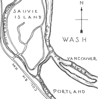
Distributary
A distributary, or a distributary channel, is a stream that branches off and flows away from a main stream channel. They are a common feature of river deltas. The phenomenon is known as river bifurcation. The opposite of a distributary is a tributary...
of the Willamette River
Willamette River
The Willamette River is a major tributary of the Columbia River, accounting for 12 to 15 percent of the Columbia's flow. The Willamette's main stem is long, lying entirely in northwestern Oregon in the United States...
that splits from the main stem a few miles upstream of the Willamette's convergence with the Columbia River
Columbia River
The Columbia River is the largest river in the Pacific Northwest region of North America. The river rises in the Rocky Mountains of British Columbia, Canada, flows northwest and then south into the U.S. state of Washington, then turns west to form most of the border between Washington and the state...
in Multnomah County in the U.S. state
U.S. state
A U.S. state is any one of the 50 federated states of the United States of America that share sovereignty with the federal government. Because of this shared sovereignty, an American is a citizen both of the federal entity and of his or her state of domicile. Four states use the official title of...
of Oregon
Oregon
Oregon is a state in the Pacific Northwest region of the United States. It is located on the Pacific coast, with Washington to the north, California to the south, Nevada on the southeast and Idaho to the east. The Columbia and Snake rivers delineate much of Oregon's northern and eastern...
. The channel flows northwest then north around Sauvie Island
Sauvie Island
Sauvie Island, in the U.S. state of Oregon, originally Wapato Island or Wappatoo Island, is the largest island along the Columbia River, at 26,000 acres , and the largest river island in the United States...
for about 21.5 miles (34.6 km) to meet the Columbia River near the city of St. Helens
St. Helens, Oregon
St. Helens is the county seat of Columbia County, Oregon. It was founded by Captain H. M. Knighton, a native of New England, in 1845 as "Plymouth". The name was changed to St. Helens in the latter part of 1850 for its view of Mount St. Helens some away in Washington. The population was 10,019 at...
, in Columbia County
Columbia County, Oregon
Columbia County is a county located in the U.S. state of Oregon. It was named for the Columbia River, which forms its eastern and northern borders. As of 2010, its population was 49,351. The county seat is St. Helens.-Economy:...
. U.S. Route 30 and tracks of the Burlington Northern Railroad
Burlington Northern Railroad
The Burlington Northern Railroad was a United States-based railroad company formed from a merger of four major U.S. railroads. Burlington Northern operated between 1970 and 1996....
run roughly parallel to the channel, and to its left, between its source and the Multnomah–Columbia county border at about the channel's river mile
River mile
In the United States, a River mile is a measure of distance in miles along a river from its mouth. River mile numbers begin at zero and increase further upstream. The corresponding metric unit using kilometers is the River kilometer...
(RM) 12.5 or river kilometer (RK) 20.1.
In its first 0.5 mile (0.80467 km), the channel receives Miller Creek from the left, then passes under Sauvie Island Bridge
Sauvie Island Bridge
The Sauvie Island Bridge crosses the Multnomah Channel of the Willamette River near Portland, Oregon, United States. The original Parker truss bridge, built in 1950 with a main span, was replaced with a tied arch bridge with a span in 2008 due to cracks discovered in 2001.-Old bridge:Opened on...
, which carries Northwest Sauvie Island Road. Below the bridge, Ennis Creek enters from the left, then McCarthy Creek from the left at RM 18. Further along, Johns Creek enters from the left, and then Joy Creek enters from the left where the channel leaves Multnomah County and enters Columbia County. About 8 miles (12.9 km) from the mouth, the channel flows around Coon Island. Shortly thereafter, Crane Slough, which drains Crane's Lake, and the Gilbert River, which drains Sturgeon Lake, enter from the right. Then the channel receives Jackson Creek from the left and Cunningham Slough from the right before flowing around Louse Island and merging with Scappoose Bay, which is on the left. St. Helens is on the left as the channel enters the Columbia, about 86.5 miles (139.2 km) from the larger stream's mouth on the Pacific Ocean.
The Multnomah Channel may have once been the main channel of the Willamette, especially before the Willamette was dredged and channelization, beginning in the late 19th century.
Uses
The Multnomah Channel is a secondary commercial waterway with nearly all commercial traffic being local and mostly consisting of gravel barges and work boats. It is an important recreational waterway for fishing, boating, and living. There are good salmon runs and record-sized walleye in the channel as well as sturgeon, catfish, and many smaller species. There are many moorages for both boats and floating homes. The Multnomah Channel Yacht ClubMultnomah Channel Yacht Club
The Multnomah Channel Yacht Club is a yacht club in Scappoose, Oregon, USA and is a member of the Columbia River Yachting Association.-Membership:...
and the Portland Boat Club (Oregon's oldest rowing club) are both located on the Multnomah Channel.