

Mount Hood Highway
Encyclopedia
The Mount Hood Highway No. 26 (see Oregon highways and routes) is the Oregon Department of Transportation
's designation for a 93.84-mile (151.02 km) highway from Portland east around the south side of Mount Hood
and north via Bennett Pass to Hood River. It is marked as U.S. Route 26 from Portland to near Mount Hood and Oregon Route 35 the rest of the way to Hood River.
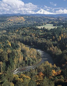
Much of the highway is part of the Mount Hood Scenic Byway, a National Scenic Byway
which connects Troutdale
with Hood River
via the southern flank of Mount Hood. The Byway's route includes parts of present-day U.S. Route 26 and Oregon Route 35 and the historic Barlow Road
through the Mount Hood Corridor. It also forms a loop with the Historic Columbia River Highway, an All-American Road.
The portion from Sandy to Barlow Pass
on the south flank of Mount Hood is aligned to the land portion of the historic Oregon Trail
. It was developed in the 1840s as the Barlow Road
.

, with access to the Oswego Highway (Oregon Route 43), Pacific Highway (Interstate 5) and Pacific Highway West (Oregon Route 10). US 26 itself heads west on Arthur Street, which is not a state-maintained Highway, to reach the Stadium Freeway (Interstate 405
).
After crossing the Willamette River
on the Ross Island Bridge, the Highway is locally known as Powell Boulevard through Portland and Gresham. State maintenance ends at the Portland/Gresham border, beginning again where the Highway turns southeast at Burnside Street east of downtown Gresham. Soon after that turn, Highway 26 uses the completed part of the Mount Hood Freeway (built only to surface expressway
standards) to Sandy, where it runs through downtown on a one-way couplet.
The section of Powell Boulevard from Interstate 205 east into downtown Gresham carries only two lanes. When I-205 was built, the ramps at Powell Boulevard were configured to only allow traffic towards the west, with US 26 east pointed along the four-lane Division Street, about 1/2 mile (1 km) to the north. (Right turns were even banned to and from the I-205 north ramps at first.) Division Street runs east into Gresham, where it meets Burnside Road, at which a right turn to the southeast leads into the Mount Hood Highway and US 26. Despite this signage pointing US 26 east on Division Street, traffic already on US 26 is pointed straight along Powell Boulevard (the Mount Hood Highway), in agreement with ODOT's route description.
East of Sandy, the highway is a (mostly) four-lane undivided highway approaching the slopes of Mount Hood; as the highway climbs up towards Government Camp
it reduces to two and three lanes. It is four lanes again through Government Camp. East of Government Camp is an interchange
with Oregon Route 35, where US 26 heads southeast on the Warm Springs Highway towards Madras
and the Mount Hood Highway heads north with Route 35.
Route 35 winds over Bennett Pass and around the eastern side of Mount Hood, and descends into the Hood River Valley. The Mount Hood Highway designation ends at the intersection with the Historic Columbia River Highway, which carries U.S. Route 30 to the west. To the north, the road continues as a spur of the Columbia River Highway No. 2 (Interstate 84), bringing US 30 back onto that freeway. Officially Route 35 heads west from there on US 30 through Hood River to end at I-84 west of that town, but all signage ends at the end of the Mount Hood Highway.
The general public uses the name Mount Hood Highway to refer to much the same route, excluding the portions inside Portland and western Gresham (which are referred to by the street name of Powell Boulevard).
Between 1955 and 1978, the 15-mile (25 km) segment of the route through southeast Portland was proposed to be moved from Powell Boulevard to a new similar alignment known as the Mount Hood Freeway. Due to intense local opposition, this proposed freeway was cancelled.
. For the first twenty miles (32 km) of the route, it follows a southwestern path along city streets: west on Glenn Otto Park Road into downtown Troutdale, connecting with Halsey Street, south along 238th Street (which veers to become 242nd Street), Burnside Street, Palmquist Road, Orient Drive, Dodge Park Boulevard, Lusted Road, and Ten Eyck Road.
 The Byway continues into Sandy
on US 26, heads west briefly on a spur to Jonsrud Viewpoint on Bluff Road, then backtracks to US 26.
It continues along U.S. Route 26 for about thirty miles, then leaves the highway proper in favor of the business loop
through Government Camp
. The Byway follows a spur just east of Government Camp to Timberline Lodge. After returning to US 26, it continues to the junction with Oregon Route 35 where it exits US 26 and goes north on OR 35 for about 40 miles (64.4 km). At the eastern outskirts of Hood River, OR 35 intersects with U.S. Route 30 and the Historic Columbia River Highway.
Oregon Department of Transportation
The Oregon Department of Transportation is a department of the state government of the U.S. state of Oregon responsible for systems of transportation. It was first established in 1969. It had been preceded by the Oregon State Highway Department which, along with the Oregon State Highway...
's designation for a 93.84-mile (151.02 km) highway from Portland east around the south side of Mount Hood
Mount Hood
Mount Hood, called Wy'east by the Multnomah tribe, is a stratovolcano in the Cascade Volcanic Arc of northern Oregon. It was formed by a subduction zone and rests in the Pacific Northwest region of the United States...
and north via Bennett Pass to Hood River. It is marked as U.S. Route 26 from Portland to near Mount Hood and Oregon Route 35 the rest of the way to Hood River.
Much of the highway is part of the Mount Hood Scenic Byway, a National Scenic Byway
National Scenic Byway
A National Scenic Byway is a road recognized by the United States Department of Transportation for its archeological, cultural, historic, natural, recreational, and/or scenic qualities. The program was established by Congress in 1991 to preserve and protect the nation's scenic but often...
which connects Troutdale
Troutdale, Oregon
Troutdale is a city in Multnomah County, Oregon, north of Gresham and east of Wood Village. As of the 2010 census, the city population was 15,962....
with Hood River
Hood River, Oregon
The city of Hood River is the seat of Hood River County, Oregon, United States. It is a port on the Columbia River, and is named for the nearby Hood River. As of the 2000 census, the city population was 5,831...
via the southern flank of Mount Hood. The Byway's route includes parts of present-day U.S. Route 26 and Oregon Route 35 and the historic Barlow Road
Barlow Road
The Barlow Road is a historic road in what is now the U.S. state of Oregon. It was built in 1846 by Sam Barlow and Philip Foster, with authorization of the Provisional Legislature of Oregon, and served as the last overland segment of the Oregon Trail...
through the Mount Hood Corridor. It also forms a loop with the Historic Columbia River Highway, an All-American Road.
The portion from Sandy to Barlow Pass
Barlow Pass (Oregon)
Barlow Pass is a mountain pass in the Cascades in Oregon, on the Oregon Trail, and a major milestone of the Barlow Road. It is the crest of the Cascade Mountains: the dividing line between watersheds of the Deschutes River and those that flow into the Sandy River.It is located on the southern...
on the south flank of Mount Hood is aligned to the land portion of the historic Oregon Trail
Oregon Trail
The Oregon Trail is a historic east-west wagon route that connected the Missouri River to valleys in Oregon and locations in between.After 1840 steam-powered riverboats and steamboats traversing up and down the Ohio, Mississippi and Missouri rivers sped settlement and development in the flat...
. It was developed in the 1840s as the Barlow Road
Barlow Road
The Barlow Road is a historic road in what is now the U.S. state of Oregon. It was built in 1846 by Sam Barlow and Philip Foster, with authorization of the Provisional Legislature of Oregon, and served as the last overland segment of the Oregon Trail...
.
Route description
The highway begins in Portland at the west end of the Ross Island BridgeRoss Island Bridge
The Ross Island Bridge is a cantilever truss bridge that spans the Willamette River in Portland, Oregon. It carries U.S. Route 26 across the river between southwest and southeast Portland...
, with access to the Oswego Highway (Oregon Route 43), Pacific Highway (Interstate 5) and Pacific Highway West (Oregon Route 10). US 26 itself heads west on Arthur Street, which is not a state-maintained Highway, to reach the Stadium Freeway (Interstate 405
Interstate 405 (Oregon)
Interstate 405 is a short Interstate Highway in Portland, Oregon. It forms a loop from Interstate 5 that travels through downtown Portland west of the Willamette River.-Route description:...
).
After crossing the Willamette River
Willamette River
The Willamette River is a major tributary of the Columbia River, accounting for 12 to 15 percent of the Columbia's flow. The Willamette's main stem is long, lying entirely in northwestern Oregon in the United States...
on the Ross Island Bridge, the Highway is locally known as Powell Boulevard through Portland and Gresham. State maintenance ends at the Portland/Gresham border, beginning again where the Highway turns southeast at Burnside Street east of downtown Gresham. Soon after that turn, Highway 26 uses the completed part of the Mount Hood Freeway (built only to surface expressway
Limited-access road
A limited-access road known by various terms worldwide, including limited-access highway, dual-carriageway and expressway, is a highway or arterial road for high-speed traffic which has many or most characteristics of a controlled-access highway , including limited or no access to adjacent...
standards) to Sandy, where it runs through downtown on a one-way couplet.
The section of Powell Boulevard from Interstate 205 east into downtown Gresham carries only two lanes. When I-205 was built, the ramps at Powell Boulevard were configured to only allow traffic towards the west, with US 26 east pointed along the four-lane Division Street, about 1/2 mile (1 km) to the north. (Right turns were even banned to and from the I-205 north ramps at first.) Division Street runs east into Gresham, where it meets Burnside Road, at which a right turn to the southeast leads into the Mount Hood Highway and US 26. Despite this signage pointing US 26 east on Division Street, traffic already on US 26 is pointed straight along Powell Boulevard (the Mount Hood Highway), in agreement with ODOT's route description.
East of Sandy, the highway is a (mostly) four-lane undivided highway approaching the slopes of Mount Hood; as the highway climbs up towards Government Camp
Government Camp, Oregon
Government Camp is an unincorporated community located in Clackamas County, Oregon, United States, south of Mount Hood and north of Tom, Dick and Harry Mountain. It is a gateway to several ski resorts, the most popular being Timberline Lodge and Mount Hood Skibowl. Also, Government Camp has its...
it reduces to two and three lanes. It is four lanes again through Government Camp. East of Government Camp is an interchange
Interchange (road)
In the field of road transport, an interchange is a road junction that typically uses grade separation, and one or more ramps, to permit traffic on at least one highway to pass through the junction without directly crossing any other traffic stream. It differs from a standard intersection, at which...
with Oregon Route 35, where US 26 heads southeast on the Warm Springs Highway towards Madras
Madras, Oregon
Madras is a city in Jefferson County, Oregon, United States. Originally called The Basin after the circular valley the city is located in, it is unclear as to whether Madras was named in 1903 for the cotton fabric called "Madras" that originated in the Madras area in India, or from the city of...
and the Mount Hood Highway heads north with Route 35.
Route 35 winds over Bennett Pass and around the eastern side of Mount Hood, and descends into the Hood River Valley. The Mount Hood Highway designation ends at the intersection with the Historic Columbia River Highway, which carries U.S. Route 30 to the west. To the north, the road continues as a spur of the Columbia River Highway No. 2 (Interstate 84), bringing US 30 back onto that freeway. Officially Route 35 heads west from there on US 30 through Hood River to end at I-84 west of that town, but all signage ends at the end of the Mount Hood Highway.
The general public uses the name Mount Hood Highway to refer to much the same route, excluding the portions inside Portland and western Gresham (which are referred to by the street name of Powell Boulevard).
Between 1955 and 1978, the 15-mile (25 km) segment of the route through southeast Portland was proposed to be moved from Powell Boulevard to a new similar alignment known as the Mount Hood Freeway. Due to intense local opposition, this proposed freeway was cancelled.
Scenic Byway
From Troutdale, the Mount Hood Scenic Byway starts at the end of the Historic Columbia River Highway where the Troutdale Bridge crosses the Sandy RiverSandy River (Oregon)
The Sandy River is a tributary of the Columbia River in northwestern Oregon in the United States. Measured by a United States Geological Survey gauge downstream of the Sandy's confluence with the Bull Run River, from the mouth, the river's average discharge is . The maximum daily recorded flow...
. For the first twenty miles (32 km) of the route, it follows a southwestern path along city streets: west on Glenn Otto Park Road into downtown Troutdale, connecting with Halsey Street, south along 238th Street (which veers to become 242nd Street), Burnside Street, Palmquist Road, Orient Drive, Dodge Park Boulevard, Lusted Road, and Ten Eyck Road.
Sandy, Oregon
Sandy is a city located in Clackamas County, Oregon, United States, and named after the nearby Sandy River. As of the 2000 census, the city had a total population of 5,385, however the 2006 estimate shows 7,070 people....
on US 26, heads west briefly on a spur to Jonsrud Viewpoint on Bluff Road, then backtracks to US 26.
It continues along U.S. Route 26 for about thirty miles, then leaves the highway proper in favor of the business loop
Business route
A business route in the United States and Canada is a short special route connected to a parent numbered highway at its beginning, then routed through the central business district of a nearby city or town, and finally reconnecting with the same parent numbered highway again at its...
through Government Camp
Government Camp, Oregon
Government Camp is an unincorporated community located in Clackamas County, Oregon, United States, south of Mount Hood and north of Tom, Dick and Harry Mountain. It is a gateway to several ski resorts, the most popular being Timberline Lodge and Mount Hood Skibowl. Also, Government Camp has its...
. The Byway follows a spur just east of Government Camp to Timberline Lodge. After returning to US 26, it continues to the junction with Oregon Route 35 where it exits US 26 and goes north on OR 35 for about 40 miles (64.4 km). At the eastern outskirts of Hood River, OR 35 intersects with U.S. Route 30 and the Historic Columbia River Highway.
Points of interest
From west to east:- Sandy RiverSandy River (Oregon)The Sandy River is a tributary of the Columbia River in northwestern Oregon in the United States. Measured by a United States Geological Survey gauge downstream of the Sandy's confluence with the Bull Run River, from the mouth, the river's average discharge is . The maximum daily recorded flow...
: the mouth close to TroutdaleTroutdale, OregonTroutdale is a city in Multnomah County, Oregon, north of Gresham and east of Wood Village. As of the 2010 census, the city population was 15,962....
is where William Robert BroughtonWilliam Robert BroughtonWilliam Robert Broughton was a British naval officer in the late 18th century. As a Lieutenant in the Royal Navy, he commanded HMS Chatham as part of the Vancouver Expedition, a voyage of exploration through the Pacific Ocean led by Captain George Vancouver in the early 1790s.-With Vancouver:In...
spotted and named Mount HoodMount HoodMount Hood, called Wy'east by the Multnomah tribe, is a stratovolcano in the Cascade Volcanic Arc of northern Oregon. It was formed by a subduction zone and rests in the Pacific Northwest region of the United States... - Portland Women's Forum State Scenic Viewpoint, also known as Chanticleer Point: views of the Columbia Gorge, Historic Columbia River Highway, Crown PointCrown Point (Oregon)Crown Point is the name of a promontory on the Columbia River Gorge and an associated state park in the U.S. state of Oregon. It is located in eastern Multnomah County, approximately 15 miles east of Portland. Crown Point is one of the scenic lookouts along the Historic Columbia River Highway,...
and Rooster RockRooster RockRooster Rock State Park is a state park located east of Corbett, in the U.S. state of Oregon. One of the features of the park is Rooster Rock, a column of basalt forming a natural obelisk, which stands near the south side of the Columbia River Gorge, in the lee of Crown Point...
State Park - Jonsrud Viewpoint: view of Sandy RiverSandy RiverThe Sandy River may refer to some locations in the United States:Communities*Sandy River Plantation, Maine, a municipalityRivers*Sandy River in Maine*Sandy River *Sandy River...
basin and Devil's Backbone, route of the Oregon TrailOregon TrailThe Oregon Trail is a historic east-west wagon route that connected the Missouri River to valleys in Oregon and locations in between.After 1840 steam-powered riverboats and steamboats traversing up and down the Ohio, Mississippi and Missouri rivers sped settlement and development in the flat...
and Barlow RoadBarlow RoadThe Barlow Road is a historic road in what is now the U.S. state of Oregon. It was built in 1846 by Sam Barlow and Philip Foster, with authorization of the Provisional Legislature of Oregon, and served as the last overland segment of the Oregon Trail... - Wildwood Recreation SiteWildwood Recreation SiteThe Wildwood Recreation Site is a natural recreation area surrounded by the Mount Hood National Forest in northern Oregon, USA. It contains of natural rainforest and five miles of interpretive trail along the Salmon River. It features Cascade Streamwatch, an underwater viewport into a mountain...
- Cascade Streamwatch, Oregon: underwater stream and fish habitat viewing, five miles (8 km) of interpretive trails along the Salmon RiverSalmon River (Clackamas County, Oregon)The Salmon River is a 33.9 mile river in Oregon's Cascade Range and drains a portion of southwestern Mount Hood.The entire length of the river is protected National Wild and Scenic River, the only such river in the contiguous 48 states....
, access to the Salmon-Huckleberry WildernessSalmon-Huckleberry WildernessThe Salmon–Huckleberry Wilderness is a wilderness area located on the southern side of Mount Hood in the northwestern Cascades of Oregon, United States. It lies within the Mount Hood National Forest and comprises of land...
via the 70 miles (112.7 km) Salmon River National Recreation TrailSalmon River National Recreation TrailThe Salmon River National Recreation Trail is a National Recreation Trail in Oregon's northern Cascade Mountains among the foothills of Mount Hood. About of the trail's length is within the Salmon-Huckleberry Wilderness, and parallels the Salmon River, though often along the top of a high... - Lost Creek Campground: Nature Trail & Old Maid Flats
- Philip Foster Farm National Historic Site
- West Barlow Tollgate: operated from 1874 to 1919
- Laurel Hill Chute: This effectively made the Barlow Road one way by its 60% grade, easily the most harrowing portion of the Oregon Trail.
- Mount Hood Cultural Center and Museum: historic photos by Ray AtkesonRay AtkesonRay Atkeson was a U.S. photographer best known for his landscape images, particularly of the American West....
in downtown Government Camp, OregonGovernment Camp, OregonGovernment Camp is an unincorporated community located in Clackamas County, Oregon, United States, south of Mount Hood and north of Tom, Dick and Harry Mountain. It is a gateway to several ski resorts, the most popular being Timberline Lodge and Mount Hood Skibowl. Also, Government Camp has its... - Timberline Lodge and Ski Area
- Trillium LakeTrillium LakeTrillium Lake is a lake situated south-southwest of Mount Hood in the U.S. state of Oregon. It is formed by a dam at the headwaters of Mud Creek, tributary to the Salmon River. It was created by the state Department of Fish and Wildlife in 1960....
/Summit Meadow: a Barlow Road tollgate from 1866 through 1870 - White RiverWhite River (Oregon)The White River is a tributary of the Deschutes River, approximately 50 mi long, in north central Oregon in the United States. It drains a scenic mountainous area of the Columbia Plateau on the east side of the Cascade Range southeast of Mount Hood. In the 1840s, a section of the Oregon...
Canyon: views of lahar and mud flows and evidence of frequent floods - Barlow PassBarlow Pass (Oregon)Barlow Pass is a mountain pass in the Cascades in Oregon, on the Oregon Trail, and a major milestone of the Barlow Road. It is the crest of the Cascade Mountains: the dividing line between watersheds of the Deschutes River and those that flow into the Sandy River.It is located on the southern...
/Pioneer Woman's Grave - Sahalie Falls: a horsetail waterfall 100 feet (30.5 m) high and 20 feet (6.1 m) wide, fed by Newton Clark Glacier and a tributary of Hood River
- Tamanawas Falls: a gentle two mile (3 km) trail along Cold Springs Creek to 100 feet (30.5 m) high falls
- Toll Bridge County Park
- Panorama Point County Park and Viewpoint
- Jesse and Winifred Hutson Museum: a National Historic Site in Parkdale, OregonParkdale, OregonParkdale is an unincorporated community in Hood River County, Oregon, United States. For statistical purposes, the United States Census Bureau has defined Parkdale as a census-designated place . The census definition of the area may not precisely correspond to local understanding of the area with...
- Mount Hood Railroad
- Historic Downtown Hood River
External links
- ORoads - Mount Hood Freeway
- Description of Mount Hood Scenic Byway, from a Federal Highway AdministrationFederal Highway AdministrationThe Federal Highway Administration is a division of the United States Department of Transportation that specializes in highway transportation. The agency's major activities are grouped into two "programs," the Federal-aid Highway Program and the Federal Lands Highway Program...
website - Description from the Hood River CountyHood River County, Oregon-Demographics:As of the census of 2000, there were 20,411 people, 7,248 households, and 5,175 families residing in the county. The population density was 39 people per square mile . There were 7,818 housing units at an average density of 15 per square mile...
Chamber Of Commerce website - Mount Hood Scenic Byway gets federal designation, a September 2005 article from Portland Business Journal
- Oregon Transportation Commission approves Byway proposal, a March 2005 press release from the official Oregon website
- Mount Hood Scenic Byway (with map), from the Oregon Tourism CommissionOregon Tourism CommissionThe Oregon Tourism Commission, which does business as Travel Oregon, is a semi-independent agency of the government of Oregon based in the state capital of Salem. The agency is run by a nine-member board appointed by the governor, and governs several programs that work to grow the state economy by...
website