

Stream gauge
Encyclopedia
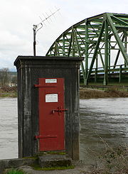
A stream gauge, stream gage or gauging station is a location used by hydrologists or environmental scientists to monitor and test terrestrial bodies of water
. Hydrometric
measurements of water surface elevation ("stage") and/or volumetric discharge
(flow) are generally taken and observations of biota
may also be made. The location of gauging stations are often found on topographical maps
. Some gauging stations are highly automated and may include telemetry
capability transmitted to a central data logging facility.
 Automated direct measurement of streamflow discharge is difficult at present. In place of the direct measurement of streamflow discharge, one or more surrogate measurements can be used to produce discharge values. In the majority of cases, a stage (the elevation of the water surface) measurement is used as the surrogate. Low gradient (or shallow-sloped) streams are highly influenced by variable downstream channel conditions. For these streams, a second stream gauge would be installed, and the slope of the water surface would be calculated between the gauges. This value would be used along with the stage measurement to more accurately determine the streamflow discharge. Within the last ten years, the technological advance of velocity sensors has allowed the use of water velocity as a reliable surrogate for streamflow discharge at sites with a stable cross-sectional area. These sensor
s are permanently mounted in the stream and measure velocity at a particular location in the stream and related to flow in a manner similar to the use of traditional water level.
In those instances where only a stage measurement is used as the surrogate, a rating curve must be constructed. A rating curve is the functional relation between stage and discharge. It is determined by making repeated discrete measurements of streamflow discharge using a velocimeter
and some means to measure the channel geometry to determine the cross-sectional area of the channel. The technicians and hydrologists responsible for determining the rating curve visit the site routinely, with special trips to measure the hydrologic extremes (floods and droughts), and make a discharge measurement by following an explicit set of instructions.
 Once the rating curve is established, it can be used in conjunction with stage measurements to determine the volumetric streamflow discharge. This record then serves as an assessment of the volume of water that passes by the stream gauge and is useful for many tasks associated with hydrology.
In those instances where a velocity measurement is additionally used as a surrogate, an index velocity determination is conducted. This analysis uses a velocity sensor, often either magnetic or acoustic, to measure the velocity of the flow at a particular location in the stream cross section. Once again, discrete measurements of streamflow discharge are made by the technician or hydrologist at a variety of stages. For each discrete determination of streamflow discharge, the mean velocity of the cross section is determined by dividing streamflow discharge by the cross-sectional area. A rating curve, similar to that used for stage-discharge determinations, is constructed using the mean velocity and the index velocity from the permanently mounted meter. An additional rating curve is constructed that relates stage of the stream to cross-sectional area. Using these two ratings, the automatically collected stage produces an estimate of the cross-sectional area, and the automatically collected index velocity produces an estimate of the mean velocity of the cross section
. The streamflow discharge is computed as the estimate of the cross section area and the estimate of the mean velocity of the streamflow.
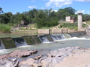 Many permanent water control structures used to improve the reliability of using water level as a surrogate for flow (improving the reliability of the rating table) are:
Other equipment commonly used at permanent stream gauge include:
Discharge
measurements of a stream or canal without an established stream gage can be made using a current meter or Acoustic Doppler Current Profiler
. One informal methods that is not acceptable for any official or scientific purpose, but can be useful is the float method, in which a floating object such as a piece of wood or orange peel is observed floating down the stream.
and Lea in the 1880s, and in Scotland on the River Garry in 1913. The national gauging station network was established in its current form by the early 1970s and consists of approximately 1500 flow measurement stations supplemented by a variable number of temporary monitoring sites. The Environment Agency
is responsible for collection and analysis of hydrometric data in England and Wales, whilst responsibility for Scotland and Northern Ireland rests with the Scottish Environment Protection Agency
and Rivers Agency
respectively.
 In the United States
, the U.S. Geological Survey (USGS) is the principal federal agency tasked with maintaining records of natural resources
. Within the USGS, the Water Resources Division carries the responsibility for monitoring water resources.
To establish a stream gage, USGS personnel first choose a site on a stream where the geometry is relatively stable and there is a suitable location to make discrete direct measurements of streamflow using specialized equipment. Many times this will be at a bridge or other stream crossing. Technicians then install equipment that measures the stage (the elevation of the water surface) or, more rarely, the velocity
of the flow. Additional equipment is installed to record and transmit these readings (via a telemeter
) to the Water Science Center office where the records are kept. The USGS has a Water Science Center office in every state within the USA.
, the national stream gauge network is the responsibility of the Zimbabwe National Water Authority. This is an extensive network covering all major rivers and catchments in the country. However, a review of existing gauges raised serious concerns about the reliability of the data of a minority of stations, due in part to ongoing funding problems.
Surface water
Surface water is water collecting on the ground or in a stream, river, lake, wetland, or ocean; it is related to water collecting as groundwater or atmospheric water....
. Hydrometric
Hydrometry
Hydrometry is the monitoring of the components of the hydrological cycle including rainfall, groundwater characteristics, as well as water quality and flow characteristics of surface waters...
measurements of water surface elevation ("stage") and/or volumetric discharge
Discharge (hydrology)
In hydrology, discharge is the volume rate of water flow, including any suspended solids , dissolved chemical species and/or biologic material , which is transported through a given cross-sectional area...
(flow) are generally taken and observations of biota
Biota (ecology)
Biota are the total collection of organisms of a geographic region or a time period, from local geographic scales and instantaneous temporal scales all the way up to whole-planet and whole-timescale spatiotemporal scales. The biota of the Earth lives in the biosphere.-See...
may also be made. The location of gauging stations are often found on topographical maps
Topographic map
A topographic map is a type of map characterized by large-scale detail and quantitative representation of relief, usually using contour lines in modern mapping, but historically using a variety of methods. Traditional definitions require a topographic map to show both natural and man-made features...
. Some gauging stations are highly automated and may include telemetry
Telemetry
Telemetry is a technology that allows measurements to be made at a distance, usually via radio wave transmission and reception of the information. The word is derived from Greek roots: tele = remote, and metron = measure...
capability transmitted to a central data logging facility.
Measurement of discharge
Sensor
A sensor is a device that measures a physical quantity and converts it into a signal which can be read by an observer or by an instrument. For example, a mercury-in-glass thermometer converts the measured temperature into expansion and contraction of a liquid which can be read on a calibrated...
s are permanently mounted in the stream and measure velocity at a particular location in the stream and related to flow in a manner similar to the use of traditional water level.
In those instances where only a stage measurement is used as the surrogate, a rating curve must be constructed. A rating curve is the functional relation between stage and discharge. It is determined by making repeated discrete measurements of streamflow discharge using a velocimeter
Velocimetry
Velocimetry is the measurement of the velocity of fluids, as often used to solve fluid dynamics problems, or to study fluid networks, as well as in industrial and process control applications, or in the creation of new kinds of fluid flow sensors...
and some means to measure the channel geometry to determine the cross-sectional area of the channel. The technicians and hydrologists responsible for determining the rating curve visit the site routinely, with special trips to measure the hydrologic extremes (floods and droughts), and make a discharge measurement by following an explicit set of instructions.
In those instances where a velocity measurement is additionally used as a surrogate, an index velocity determination is conducted. This analysis uses a velocity sensor, often either magnetic or acoustic, to measure the velocity of the flow at a particular location in the stream cross section. Once again, discrete measurements of streamflow discharge are made by the technician or hydrologist at a variety of stages. For each discrete determination of streamflow discharge, the mean velocity of the cross section is determined by dividing streamflow discharge by the cross-sectional area. A rating curve, similar to that used for stage-discharge determinations, is constructed using the mean velocity and the index velocity from the permanently mounted meter. An additional rating curve is constructed that relates stage of the stream to cross-sectional area. Using these two ratings, the automatically collected stage produces an estimate of the cross-sectional area, and the automatically collected index velocity produces an estimate of the mean velocity of the cross section
Cross section (geometry)
In geometry, a cross-section is the intersection of a figure in 2-dimensional space with a line, or of a body in 3-dimensional space with a plane, etc...
. The streamflow discharge is computed as the estimate of the cross section area and the estimate of the mean velocity of the streamflow.
Equipment commonly used for stream gauging
- V-notch,
- broad-crested,
- sharp-crested and
- combination weirWeirA weir is a small overflow dam used to alter the flow characteristics of a river or stream. In most cases weirs take the form of a barrier across the river that causes water to pool behind the structure , but allows water to flow over the top...
s - FlumeFlumeA flume is an open artificial water channel, in the form of a gravity chute, that leads water from a diversion dam or weir completely aside a natural flow. Often, the flume is an elevated box structure that follows the natural contours of the land. These have been extensively used in hydraulic...
s
Other equipment commonly used at permanent stream gauge include:
- Cableways - for suspending a hydrographer and current meter over a river to make high flow measurement
- Water pressure measuring device (Bubbler) - to measure water level via pressure (typically done directly in-stream without a stilling well)
- Stilling well - to provide a calm water level that can be measured by a sensor
- Stage encoder - a potentiometerPotentiometerA potentiometer , informally, a pot, is a three-terminal resistor with a sliding contact that forms an adjustable voltage divider. If only two terminals are used , it acts as a variable resistor or rheostat. Potentiometers are commonly used to control electrical devices such as volume controls on...
with a wheel and pulley system connected to a float in a stilling well to provide an electronic reading of the water level - Simple ultrasonic devicesUltrasonic sensorUltrasonic sensors work on a principle similar to radar or sonar which evaluate attributes of a target by interpreting the echoes from radio or sound waves respectively. Ultrasonic sensors generate high frequency sound waves and evaluate the echo which is received back by the sensor...
- to measure water level in a stilling well or directly in a canal. - Electromagnetic gauges
Discharge
Discharge (hydrology)
In hydrology, discharge is the volume rate of water flow, including any suspended solids , dissolved chemical species and/or biologic material , which is transported through a given cross-sectional area...
measurements of a stream or canal without an established stream gage can be made using a current meter or Acoustic Doppler Current Profiler
Acoustic Doppler Current Profiler
An Acoustic Doppler Current Profiler is a sonar that attempts to produce a record of water current velocities for a range of depths. They are made of ceramic materials, and contain transducers, an amplifier, a receiver, a mixer, an oscillator, a clock, a temperature sensor, a compass, a pitch and...
. One informal methods that is not acceptable for any official or scientific purpose, but can be useful is the float method, in which a floating object such as a piece of wood or orange peel is observed floating down the stream.
National Stream Gauge Networks
United Kingdom
The first routine meaurements of river flow in England began on the ThamesRiver Thames
The River Thames flows through southern England. It is the longest river entirely in England and the second longest in the United Kingdom. While it is best known because its lower reaches flow through central London, the river flows alongside several other towns and cities, including Oxford,...
and Lea in the 1880s, and in Scotland on the River Garry in 1913. The national gauging station network was established in its current form by the early 1970s and consists of approximately 1500 flow measurement stations supplemented by a variable number of temporary monitoring sites. The Environment Agency
Environment Agency
The Environment Agency is a British non-departmental public body of the Department for Environment, Food and Rural Affairs and an Assembly Government Sponsored Body of the Welsh Assembly Government that serves England and Wales.-Purpose:...
is responsible for collection and analysis of hydrometric data in England and Wales, whilst responsibility for Scotland and Northern Ireland rests with the Scottish Environment Protection Agency
Scottish Environment Protection Agency
The Scottish Environment Protection Agency is Scotland’s environmental regulator. Its main role is to protect and improve Scotland's environment...
and Rivers Agency
Rivers Agency
The Rivers Agency is an Executive Agency of the Department of Agriculture and Rural Development . It is the statutory drainage and flood defence authority for Northern Ireland. DARD is the competent authority for the implementation of the EU Floods directive and has deligated the day to day...
respectively.
United States
United States
The United States of America is a federal constitutional republic comprising fifty states and a federal district...
, the U.S. Geological Survey (USGS) is the principal federal agency tasked with maintaining records of natural resources
Natural Resources
Natural Resources is a soul album released by Motown girl group Martha Reeves and the Vandellas in 1970 on the Gordy label. The album is significant for the Vietnam War ballad "I Should Be Proud" and the slow jam, "Love Guess Who"...
. Within the USGS, the Water Resources Division carries the responsibility for monitoring water resources.
To establish a stream gage, USGS personnel first choose a site on a stream where the geometry is relatively stable and there is a suitable location to make discrete direct measurements of streamflow using specialized equipment. Many times this will be at a bridge or other stream crossing. Technicians then install equipment that measures the stage (the elevation of the water surface) or, more rarely, the velocity
Velocity
In physics, velocity is speed in a given direction. Speed describes only how fast an object is moving, whereas velocity gives both the speed and direction of the object's motion. To have a constant velocity, an object must have a constant speed and motion in a constant direction. Constant ...
of the flow. Additional equipment is installed to record and transmit these readings (via a telemeter
Telemetry
Telemetry is a technology that allows measurements to be made at a distance, usually via radio wave transmission and reception of the information. The word is derived from Greek roots: tele = remote, and metron = measure...
) to the Water Science Center office where the records are kept. The USGS has a Water Science Center office in every state within the USA.
Zimbabwe
In ZimbabweZimbabwe
Zimbabwe is a landlocked country located in the southern part of the African continent, between the Zambezi and Limpopo rivers. It is bordered by South Africa to the south, Botswana to the southwest, Zambia and a tip of Namibia to the northwest and Mozambique to the east. Zimbabwe has three...
, the national stream gauge network is the responsibility of the Zimbabwe National Water Authority. This is an extensive network covering all major rivers and catchments in the country. However, a review of existing gauges raised serious concerns about the reliability of the data of a minority of stations, due in part to ongoing funding problems.
See also
- HydrographHydrographA hydrograph is a graph showing the rate of flow versus time past a specific point in a river, or other channel or conduit carrying flow...
- HyetographHyetographA hyetograph is a graphical representation of the distribution of rainfall over time. For example, in the 24-hour rainfall distributions as developed by the Soil Conservation Service , rainfall intensity progressively increases until it reaches a maximum and then gradually decreases...
- Hydrological modellingHydrological modellingHydrologic models are simplified, conceptual representations of a part of the hydrologic cycle. They are primarily used for hydrologic prediction and for understanding hydrologic processes. Two major types of hydrologic models can be distinguished:...
- Hydrological transport modelHydrological transport modelAn hydrological transport model is a mathematical model used to simulate river or stream flow and calculate water quality parameters. These models generally came into use in the 1960s and 1970s when demand for numerical forecasting of water quality was driven by environmental legislation, and at...
- Water column
External links
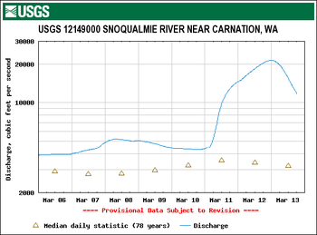
- Contoocook River Streamflow-Gaging Station, Water Resources of New Hampshire and Vermont
- "USGS Surface-Water Data for the Nation"
- UK Hydrometric Register (pdf) A catalogue of river flow gauging stations and observation wells and boreholes in the United Kingdom together with summary hydrometric and spatial statistics.
- "Radio Gauge Warns of Flood as Water Rises" Popular Mechanics, July 1935