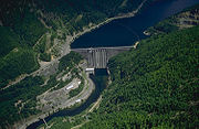
Detroit Dam
Encyclopedia

United States Army Corps of Engineers
The United States Army Corps of Engineers is a federal agency and a major Army command made up of some 38,000 civilian and military personnel, making it the world's largest public engineering, design and construction management agency...
on the North Santiam River
North Santiam River
The North Santiam River is a tributary of the Santiam River in western Oregon in the United States. It drains of the Cascade Range on the eastern side of the Willamette Valley east of Salem....
between Linn County
Linn County, Oregon
Linn County is a county located in the U.S. state of Oregon. It is named in honor of Lewis F. Linn, a U.S. Senator from Missouri who advocated the American occupation of the Oregon Country. By the 2010 US census the population of Linn county was 116,672 showing a 13.2% growth since the 2000 census...
and Marion County
Marion County, Oregon
Marion County is a county located in the U.S. state of Oregon. It was originally named the Champooick District, after Champoeg, a meeting place on the Willamette River. On September 3, 1849, the territorial legislature renamed it in honor of Francis Marion, a Continental Army general of the...
, Oregon
Oregon
Oregon is a state in the Pacific Northwest region of the United States. It is located on the Pacific coast, with Washington to the north, California to the south, Nevada on the southeast and Idaho to the east. The Columbia and Snake rivers delineate much of Oregon's northern and eastern...
, in the Cascades
Cascade Range
The Cascade Range is a major mountain range of western North America, extending from southern British Columbia through Washington and Oregon to Northern California. It includes both non-volcanic mountains, such as the North Cascades, and the notable volcanoes known as the High Cascades...
. The dam
Dam
A dam is a barrier that impounds water or underground streams. Dams generally serve the primary purpose of retaining water, while other structures such as floodgates or levees are used to manage or prevent water flow into specific land regions. Hydropower and pumped-storage hydroelectricity are...
created 400 foot (122 m) deep Detroit Lake
Detroit Lake
Detroit Lake is a reservoir impounded by the Detroit Dam on the North Santiam River southeast of Salem, Oregon, United States.The lake is adjacent to Oregon Route 22 near the city of Detroit....
, more than 9 miles (14 km) long with 32 miles (51 km) of shoreline.
The dam, dedicated on June 10, 1953, was authorized for the purposes of flood control, power generation, navigation, and irrigation. Other uses are fishery, water quality, and recreation.
Fishing is allowed from the dam.
- Drainage area: 437 mi² (1,132 km²)
- Maximum inflow: 63,200 ft³/s (1,790 m³/s) 1909
- Lake Elevation
- Maximum pool: 1,574 ft (480 m)
- Full pool: 1,569 ft (478 m)
- Minimum flood control pool: 1,450 ft (442 m)
- Usable storage (1,425.0 to 1,563.5 ft) = 321000 acre.ft
- Powerhouse
- Number of units: 2
- Nameplate capacity: 100 MW
- Overload capacity: 115 MW
- Hydraulic capacity: 5,340 ft³/s (151 m³/s)
External links
- http://www.nwd-wc.usace.army.mil/nwp/graphics/gifs/det.gif Corps of Engineers plot of lake level for last 12 months

