

List of crossings of the Willamette River
Encyclopedia
This is a list of bridge
s and other crossings of the Willamette River
in the U.S. state
of Oregon
from the Columbia River
upstream to its source.
The river's "source" is at the confluence of the Middle Fork Willamette River
and Coast Fork Willamette River
at 44.023318°N 123.023897°W
Bridge
A bridge is a structure built to span physical obstacles such as a body of water, valley, or road, for the purpose of providing passage over the obstacle...
s and other crossings of the Willamette River
Willamette River
The Willamette River is a major tributary of the Columbia River, accounting for 12 to 15 percent of the Columbia's flow. The Willamette's main stem is long, lying entirely in northwestern Oregon in the United States...
in the U.S. state
U.S. state
A U.S. state is any one of the 50 federated states of the United States of America that share sovereignty with the federal government. Because of this shared sovereignty, an American is a citizen both of the federal entity and of his or her state of domicile. Four states use the official title of...
of Oregon
Oregon
Oregon is a state in the Pacific Northwest region of the United States. It is located on the Pacific coast, with Washington to the north, California to the south, Nevada on the southeast and Idaho to the east. The Columbia and Snake rivers delineate much of Oregon's northern and eastern...
from the Columbia River
Columbia River
The Columbia River is the largest river in the Pacific Northwest region of North America. The river rises in the Rocky Mountains of British Columbia, Canada, flows northwest and then south into the U.S. state of Washington, then turns west to form most of the border between Washington and the state...
upstream to its source.
Portland
| Image | Crossing | Carries | Location | River mile River mile In the United States, a River mile is a measure of distance in miles along a river from its mouth. River mile numbers begin at zero and increase further upstream. The corresponding metric unit using kilometers is the River kilometer... |
Year built | Coordinates |
|---|---|---|---|---|---|---|
 |
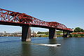
St. Johns Bridge St. Johns Bridge The St. Johns Bridge is a steel suspension bridge that spans the Willamette River in Portland, Oregon, USA, between the St. Johns neighborhood and the northwest industrial area around Linnton. It is the only suspension bridge in the Willamette Valley and one of three public highway suspension... |
 U.S. Route 30 Bypass U.S. Route 30 Bypass |
Portland Portland, Oregon Portland is a city located in the Pacific Northwest, near the confluence of the Willamette and Columbia rivers in the U.S. state of Oregon. As of the 2010 Census, it had a population of 583,776, making it the 29th most populous city in the United States... |
5.8 | 1931 | 45°35′07"N 122°45′52"W |
| |
Burlington Northern Railroad Bridge 5.1 Burlington Northern Railroad Bridge 5.1 The Burlington Northern Railroad Bridge 5.1 or BNSF Railway Bridge 5.1, also known as the St. Johns Railroad Bridge or the Willamette River Railroad Bridge, is a through truss railway bridge with a vertical lift that spans the Willamette River in Portland, Oregon, United States... |
BNSF Railway BNSF Railway The BNSF Railway is a wholly owned subsidiary of Berkshire Hathaway Inc., and is headquartered in Fort Worth, Texas. It is one of seven North American Class I railroads and the second largest freight railroad network in North America, second only to the Union Pacific Railroad, its primary... |
Portland Portland, Oregon Portland is a city located in the Pacific Northwest, near the confluence of the Willamette and Columbia rivers in the U.S. state of Oregon. As of the 2010 Census, it had a population of 583,776, making it the 29th most populous city in the United States... |
7.0 | 1908 | 45°34′36"N 122°44′51"W |
 |
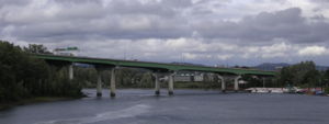
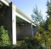
Fremont Bridge | .svg.png) Interstate 405 Interstate 405Interstate 405 (Oregon) Interstate 405 is a short Interstate Highway in Portland, Oregon. It forms a loop from Interstate 5 that travels through downtown Portland west of the Willamette River.-Route description:... |
Portland Portland, Oregon Portland is a city located in the Pacific Northwest, near the confluence of the Willamette and Columbia rivers in the U.S. state of Oregon. As of the 2010 Census, it had a population of 583,776, making it the 29th most populous city in the United States... |
11.1 | 1973 | 45°32′16"N 122°40′59"W |
 |
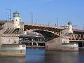
Broadway Bridge Broadway Bridge (Portland) The Broadway Bridge is a bascule bridge that spans the Willamette River in Portland, Oregon, U.S. It was the first bascule bridge built in Portland and the longest in the world at the time of its completion. It is the longest Rall-type bascule bridge still in existence.-History and description:The... |
Broadway | Portland Portland, Oregon Portland is a city located in the Pacific Northwest, near the confluence of the Willamette and Columbia rivers in the U.S. state of Oregon. As of the 2010 Census, it had a population of 583,776, making it the 29th most populous city in the United States... |
11.7 | 1913 | 45°31′55"N 122°40′27"W |
| |
Steel Bridge Steel Bridge The Steel Bridge is a through truss, double lift bridge across the Willamette River in Portland, Oregon, United States. Its lower deck carries railroad and bicycle/pedestrian traffic, while the upper deck carries road traffic and light rail , making the bridge one of the most multimodal in the world... |
Union Pacific Railway Amtrak Amtrak The National Railroad Passenger Corporation, doing business as Amtrak , is a government-owned corporation that was organized on May 1, 1971, to provide intercity passenger train service in the United States. "Amtrak" is a portmanteau of the words "America" and "track". It is headquartered at Union... MAX Light Rail Glisan Street, Interstate Avenue Formerly Harbor Drive Harbor Drive Harbor Drive is the name of a street in Portland, Oregon, which was formerly a freeway that carried U.S. Route 99W along the western shore of the Willamette River in the downtown area... (former  Oregon Route 99W) Oregon Route 99W) |
Portland Portland, Oregon Portland is a city located in the Pacific Northwest, near the confluence of the Willamette and Columbia rivers in the U.S. state of Oregon. As of the 2010 Census, it had a population of 583,776, making it the 29th most populous city in the United States... |
12.1 | 1912 | 45°31′39"N 122°40′09"W |
 |
Burnside Bridge Burnside Bridge The Burnside Bridge is a bascule bridge that spans the Willamette River in Portland, Oregon.-Design:Including approaches, the Burnside has a total length of and a center span. While lowered this span is normally above the river. The deck is made of concrete, which contributes to its being one of... |
Burnside Street | Portland Portland, Oregon Portland is a city located in the Pacific Northwest, near the confluence of the Willamette and Columbia rivers in the U.S. state of Oregon. As of the 2010 Census, it had a population of 583,776, making it the 29th most populous city in the United States... |
12.4 | 1926 | 45°31′23"N 122°40′03"W |
 |
Morrison Bridge Morrison Bridge The Morrison Bridge is a bascule bridge that spans the Willamette River in Portland, Oregon.The original Morrison Bridge was a wooden truss swing span bridge completed on April 12, 1887 as the first Willamette River bridge in Portland and the longest bridge west of the Mississippi River... |
Morrison Street | Portland Portland, Oregon Portland is a city located in the Pacific Northwest, near the confluence of the Willamette and Columbia rivers in the U.S. state of Oregon. As of the 2010 Census, it had a population of 583,776, making it the 29th most populous city in the United States... |
12.8 | 1958 | 45°31′04"N 122°40′11"W |
| |
Hawthorne Bridge Hawthorne Bridge The Hawthorne Bridge is a truss bridge with a vertical lift that spans the Willamette River in Portland, Oregon, joining Hawthorne Boulevard and Madison Street. It is the oldest vertical-lift bridge in operation in the United States and the oldest highway bridge in Portland... |
Hawthorne Boulevard | Portland Portland, Oregon Portland is a city located in the Pacific Northwest, near the confluence of the Willamette and Columbia rivers in the U.S. state of Oregon. As of the 2010 Census, it had a population of 583,776, making it the 29th most populous city in the United States... |
13.1 | 1910 | 45°30′47"N 122°40′14"W |
| |
Marquam Bridge | .svg.png) Interstate 5 Interstate 5 |
Portland Portland, Oregon Portland is a city located in the Pacific Northwest, near the confluence of the Willamette and Columbia rivers in the U.S. state of Oregon. As of the 2010 Census, it had a population of 583,776, making it the 29th most populous city in the United States... |
13.5 | 1966 | 45°30′29"N 122°40′09"W |
| |
Ross Island Bridge Ross Island Bridge The Ross Island Bridge is a cantilever truss bridge that spans the Willamette River in Portland, Oregon. It carries U.S. Route 26 across the river between southwest and southeast Portland... |
 U.S. Route 26/Powell Boulevard U.S. Route 26/Powell Boulevard |
Portland Portland, Oregon Portland is a city located in the Pacific Northwest, near the confluence of the Willamette and Columbia rivers in the U.S. state of Oregon. As of the 2010 Census, it had a population of 583,776, making it the 29th most populous city in the United States... |
14.0 | 1926 | 45°30′04"N 122°39′52"W |
 |
Sellwood Bridge Sellwood Bridge The Sellwood Bridge is a truss bridge that spans the Willamette River in Portland, Oregon, in the United States. It was Portland's first fixed-span bridge and, being the only river crossing for miles in each direction, is the busiest two-lane bridge in Oregon... |
Tacoma Street | Portland Portland, Oregon Portland is a city located in the Pacific Northwest, near the confluence of the Willamette and Columbia rivers in the U.S. state of Oregon. As of the 2010 Census, it had a population of 583,776, making it the 29th most populous city in the United States... |
16.5 | 1925 | 45°27′52"N 122°39′56"W |
Northern Willamette Valley
| Image | Crossing | Carries | Location | River mile River mile In the United States, a River mile is a measure of distance in miles along a river from its mouth. River mile numbers begin at zero and increase further upstream. The corresponding metric unit using kilometers is the River kilometer... |
Year built | Coordinates |
|---|---|---|---|---|---|---|
 |
Lake Oswego Railroad Bridge Lake Oswego Railroad Bridge The Lake Oswego Railroad Bridge is a truss railroad bridge that spans the Willamette River between Lake Oswego, Oregon and Milwaukie, Oregon... |
Portland and Western Railroad Portland and Western Railroad The Portland and Western Railroad is a Class II railroad serving the U.S. state of Oregon, and is a wholly owned subsidiary of shortline and regional railroad holding company Genesee & Wyoming Inc... |
Lake Oswego Lake Oswego, Oregon Lake Oswego is a city located primarily in Clackamas County in the U.S. state of Oregon. Small portions of the city are also located in neighboring Multnomah and Washington counties. Located south of Portland surrounding the Oswego Lake, the town was founded in 1847 and incorporated as Oswego in... /Milwaukie Milwaukie, Oregon Milwaukie is a city in Clackamas County, Oregon, United States. A very small portion of the city extends into Multnomah County. The population was 20,291 at the 2010 census. Founded in 1848 on the banks of the Willamette River, the city, known as the Dogwood City of the West, was incorporated in... |
20.0 | 1910 | 45°25′30"N 122°39′17"W |
 |
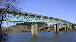
Abernethy Bridge Abernethy Bridge The Abernethy Bridge is a steel plate and box girder bridge that spans the Willamette River between Oregon City and West Linn, Oregon, USA. It is also known as the Oregon City Freeway Bridge and the I-205 Bridge as it carries Interstate 205.... |
.svg.png) Interstate 205 Interstate 205Interstate 205 (Oregon-Washington) Interstate 205 is a loop route that serves the Portland—Vancouver metropolitan area in the U.S. states of Oregon and Washington. I-205 is officially named the War Veterans Memorial Freeway, and is also known as the East Portland Freeway... |
Oregon City Oregon City, Oregon Oregon City was the first city in the United States west of the Rocky Mountains to be incorporated. It is the county seat of Clackamas County, Oregon... |
25.0 | 1970 | 45°21′52"N 122°36′15"W |
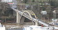 |
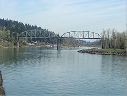
Oregon City Bridge Oregon City Bridge The Oregon City Bridge is a steel through arch bridge spanning the Willamette River between Oregon City and West Linn, Oregon, United States. It was built and is owned by the Oregon Department of Transportation as part of Oregon Route 43 and is the third southernmost Willamette bridge in the... |
 OR 43 OR 43 |
Oregon City Oregon City, Oregon Oregon City was the first city in the United States west of the Rocky Mountains to be incorporated. It is the county seat of Clackamas County, Oregon... |
26.0 | 1922 | 45°21′32"N 122°36′35"W |
| |
2 sets of aerial electric cable crossings | West Linn West Linn, Oregon West Linn is a city in Clackamas County, Oregon, United States. Now a prosperous southern suburb of Portland, West Linn has a history of early development, prompted by the opportunity to harvest energy from nearby Willamette Falls. It was named after Senator Dr. Lewis Fields Linn of Ste... /Canby Canby, Oregon Canby is a city in Clackamas County, Oregon, United States. The population was 15,829 at the 2010 census. It is located on Oregon Route 99E, two miles northeast of Barlow.-History:... |
30.0 | 45.31774°N 122.66585°W | ||
| |
aerial electric power for the Canby Ferry | Canby Canby, Oregon Canby is a city in Clackamas County, Oregon, United States. The population was 15,829 at the 2010 census. It is located on Oregon Route 99E, two miles northeast of Barlow.-History:... |
34.37 | 45.30009°N 122.69192°W | ||
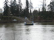 |
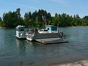
Canby Ferry | SW Mountain Rd (on the north), N Locust St (on the south) | Canby Canby, Oregon Canby is a city in Clackamas County, Oregon, United States. The population was 15,829 at the 2010 census. It is located on Oregon Route 99E, two miles northeast of Barlow.-History:... |
34.4 | 1911 | 45.30011°N 122.69273°W |
| |
aerial electric cable crossing | Molalla River State Park Molalla River State Park The Molalla River State Park is located in U.S. state of Oregon. It is a few miles north of Canby, and half a mile from the Canby Ferry. The park is south of the Willamette River and east of the Molalla River, at the confluence of the Pudding, Molalla and Willamette rivers. The Pudding River flows... |
35.98 | 45.30214°N 122.72207°W | ||
 |
Boone Bridge | Interstate 5 |
Wilsonville Wilsonville, Oregon Wilsonville is a city primarily in Clackamas County, Oregon, United States. A portion of the northern section of the city is in Washington County. Originally founded as Boones Landing due to the Boones Ferry which crossed the Willamette River at the location, the community became Wilsonville in... |
38.3 | 1954 | 45°17′31"N 122°46′10"W |
| |
Wilsonville railroad bridge | Portland & Western Railroad | Wilsonville Wilsonville, Oregon Wilsonville is a city primarily in Clackamas County, Oregon, United States. A portion of the northern section of the city is in Washington County. Originally founded as Boones Landing due to the Boones Ferry which crossed the Willamette River at the location, the community became Wilsonville in... |
38.5 | 1975 | 45°17′35"N 122°46′35"W |
| |
Oregon Route 219 bridge |  OR 219 OR 219 |
Newberg Newberg, Oregon -Demographics:As of the census of 2000, there were 18,064 people, 6,099 households, and 4,348 families residing in the city. The population density was 3,599.4 people per square mile . There were 6,435 housing units at an average density of 1,282.2 per square mile... |
48.3 | 1958 | 45°16′04"N 122°56′36"W |
| |
Champoeg Road bridge | Pipeline | Newberg Newberg, Oregon -Demographics:As of the census of 2000, there were 18,064 people, 6,099 households, and 4,348 families residing in the city. The population density was 3,599.4 people per square mile . There were 6,435 housing units at an average density of 1,282.2 per square mile... |
50.0 | 45.28377°N 122.96222°W |
Middle Willamette Valley
| Image | Crossing | Carries | Location | River mile River mile In the United States, a River mile is a measure of distance in miles along a river from its mouth. River mile numbers begin at zero and increase further upstream. The corresponding metric unit using kilometers is the River kilometer... |
Year built | Coordinates |
|---|---|---|---|---|---|---|
 |
Wheatland Ferry Wheatland Ferry The Wheatland Ferry is a cable ferry that connects Marion County and Yamhill County across the Willamette River in the U.S. state of Oregon. The ferry travels approximately 580 feet across the river, depending on the height of the river, and is powered by two electric motors connected to an... |
Wheatland Road | Wheatland Wheatland, Oregon Wheatland is an unincorporated community in Yamhill County, Oregon, United States. It is near the Willamette River where the Wheatland Ferry takes traffic across the river into Marion County. Its elevation is ; it is in the Pacific Time Zone.-External links:... |
72.0 | 1844 | 45°05′25"N 123°02′42"W |
| |
Union Street Railroad Bridge | (formerly) Black Rock Rail Line, (currently) Pedestrians, bicycles, emergency vehicles | Salem Salem, Oregon Salem is the capital of the U.S. state of Oregon, and the county seat of Marion County. It is located in the center of the Willamette Valley alongside the Willamette River, which runs north through the city. The river forms the boundary between Marion and Polk counties, and the city neighborhood... |
84.1 | 1913 | 44°56′50"N 123°02′30"W |
| |
Marion Street Bridge Marion Street Bridge The Marion Street Bridge is an automobile bridge located in Salem, Oregon, United States. It spans the Willamette River to connect Salem and West Salem, and acts as a conduit for Oregon Route 22. The bridge carries vehicular traffic one way westbound... |
 OR 22/Marion Street OR 22/Marion Street |
Salem Salem, Oregon Salem is the capital of the U.S. state of Oregon, and the county seat of Marion County. It is located in the center of the Willamette Valley alongside the Willamette River, which runs north through the city. The river forms the boundary between Marion and Polk counties, and the city neighborhood... |
84.4 | 1952 | 44°56′45"N 123°02′33"W |
| |
Center Street Bridge Center Street Bridge The Center Street Bridge is an automobile bridge located in Salem, Oregon, United States. It spans the Willamette River, connecting West Salem and Oregon Route 22 to Salem. It carries vehicle traffic eastbound from Route 22 and directly from Wallace Road. The bridge was widened in 1983 to four lanes... |
OR 22/Center Street |
Salem Salem, Oregon Salem is the capital of the U.S. state of Oregon, and the county seat of Marion County. It is located in the center of the Willamette Valley alongside the Willamette River, which runs north through the city. The river forms the boundary between Marion and Polk counties, and the city neighborhood... |
84.5 | 1918 | 44°56′42"N 123°02′36"W |
| |
Independence Street Bridge | River Road South | Independence Independence, Oregon Independence is a city in Polk County, Oregon, United States, on the west bank of the Willamette River along Oregon Route 51, and east of nearby Monmouth. It is part of the Salem Metropolitan Statistical Area... |
97.1 | 1950 | 44°50′44"N 123°10′47"W |
 |
Buena Vista Ferry | Buena Vista Road | Buena Vista Buena Vista, Oregon Buena Vista is an unincorporated community in Polk County, Oregon, United States. It is located on the Willamette River, and is the western landing for the Buena Vista Ferry. It is approximately 6 miles south-southeast of Independence.-History:... |
106.0 | 1851 | 44°46′12"N 123°08′45"W |
| |
Toledo District Willamette Bridge | Portland and Western Railroad Portland and Western Railroad The Portland and Western Railroad is a Class II railroad serving the U.S. state of Oregon, and is a wholly owned subsidiary of shortline and regional railroad holding company Genesee & Wyoming Inc... /Toledo District |
Albany Albany, Oregon Albany is the eleventh largest city in the U.S. state of Oregon, and is the county seat of Linn County. It is located in the Willamette Valley at the confluence of the Calapooia River and the Willamette River in both Linn and Benton counties, just east of Corvallis and south of Salem. It is... |
119.7 | 44.64085°N 123.09677°W | |
| |
Lyon Street Bridge |  U.S. Route 20/Lyon Street U.S. Route 20/Lyon Street |
Albany Albany, Oregon Albany is the eleventh largest city in the U.S. state of Oregon, and is the county seat of Linn County. It is located in the Willamette Valley at the confluence of the Calapooia River and the Willamette River in both Linn and Benton counties, just east of Corvallis and south of Salem. It is... |
120.0 | 1971 | 44.63917°N 123.10587°W |
| |
Ellsworth Street Bridge Ellsworth Street Bridge The Ellsworth Street Bridge is a highway bridge that crosses the Willamette River in Albany, Oregon, United States. Built in 1925, the two-lane structure carries U.S. Route 20 eastbound traffic, with the adjacent Lyon Street Bridge carrying westbound traffic... |
U.S. Route 20/Ellsworth Street |
Albany Albany, Oregon Albany is the eleventh largest city in the U.S. state of Oregon, and is the county seat of Linn County. It is located in the Willamette Valley at the confluence of the Calapooia River and the Willamette River in both Linn and Benton counties, just east of Corvallis and south of Salem. It is... |
120.1 | 1925 | 44.63924°N 123.10666°W |
| |
Harrison Street Bridge |  Oregon Route 34/Harrison Street Oregon Route 34/Harrison Street |
Corvallis Corvallis, Oregon Corvallis is a city located in central western Oregon, United States. It is the county seat of Benton County and the principal city of the Corvallis, Oregon Metropolitan Statistical Area, which encompasses all of Benton County. As of the 2010 United States Census, the population was 54,462.... |
131.5 | 1964 | 44.5661°N 123.25622°W |
| |
Van Buren Street Bridge Van Buren Street Bridge The Van Buren Street Bridge is a swing span, steel motor vehicle bridge spanning the Willamette River at Corvallis in the U.S. state of Oregon. Opened in 1913, the black colored bridge was the first bridge across the river at Corvallis and is now the third oldest bridge across the river... |
Oregon Route 34/Van Buren Street |
Corvallis Corvallis, Oregon Corvallis is a city located in central western Oregon, United States. It is the county seat of Benton County and the principal city of the Corvallis, Oregon Metropolitan Statistical Area, which encompasses all of Benton County. As of the 2010 United States Census, the population was 54,462.... |
131.5 | 1913 | 44.56541°N 123.25652°W |
| |
Corvallis Bypass Bridge | Oregon Route 34 Bypass |
Corvallis Corvallis, Oregon Corvallis is a city located in central western Oregon, United States. It is the county seat of Benton County and the principal city of the Corvallis, Oregon Metropolitan Statistical Area, which encompasses all of Benton County. As of the 2010 United States Census, the population was 54,462.... |
132.95 | 1992 | 44.55814°N 123.25987°W |
Southern Willamette Valley
| Image | Crossing | Carries | Location | River mile River mile In the United States, a River mile is a measure of distance in miles along a river from its mouth. River mile numbers begin at zero and increase further upstream. The corresponding metric unit using kilometers is the River kilometer... |
Year built | Coordinates |
|---|---|---|---|---|---|---|
| |
OR 99E bridge |  OR 99E OR 99E |
Harrisburg Harrisburg, Oregon Harrisburg is a city in Linn County, Oregon, United States. The population was 2,795 at the 2000 census.-Geography:According to the United States Census Bureau, the city has a total area of , of which, of it is land and of it is water.... |
161.2 | 1925 | 44.26708°N 123.17483°W |
| |
rail bridge | Portland and Western Railroad Portland and Western Railroad The Portland and Western Railroad is a Class II railroad serving the U.S. state of Oregon, and is a wholly owned subsidiary of shortline and regional railroad holding company Genesee & Wyoming Inc... |
Junction City Junction City, Oregon Junction City is a city in Lane County, Oregon, United States. The population was 5,392 at the 2010 census.- History :In the 1870s, Junction City was named by railroad magnate Ben Holladay, who decided this would be where the rail line on the east side of the Willamette Valley would meet the rail... |
162.7 | 44.24864°N 123.17538°W | |
| |
rail bridge | Union Pacific Railroad Union Pacific Railroad The Union Pacific Railroad , headquartered in Omaha, Nebraska, is the largest railroad network in the United States. James R. Young is president, CEO and Chairman.... Amtrak Amtrak The National Railroad Passenger Corporation, doing business as Amtrak , is a government-owned corporation that was organized on May 1, 1971, to provide intercity passenger train service in the United States. "Amtrak" is a portmanteau of the words "America" and "track". It is headquartered at Union... |
Junction City Junction City, Oregon Junction City is a city in Lane County, Oregon, United States. The population was 5,392 at the 2010 census.- History :In the 1870s, Junction City was named by railroad magnate Ben Holladay, who decided this would be where the rail line on the east side of the Willamette Valley would meet the rail... |
162.8 | 44.24815°N 123.17451°W | |
| |
Beltline Highway (westbound) |  OR 569 OR 569Oregon Route 569 Oregon Route 569 is an Oregon state highway serving as an outer quarter-loop in Eugene and Springfield. OR 569 comprises part of the Beltline Highway No. 69 . It is long and runs east–west... |
Eugene Eugene, Oregon Eugene is the second largest city in the U.S. state of Oregon and the seat of Lane County. It is located at the south end of the Willamette Valley, at the confluence of the McKenzie and Willamette rivers, about east of the Oregon Coast.As of the 2010 U.S... |
178.2 | 1961 | 44.09525°N 123.10651°W |
| |
Beltline Highway (eastbound) | OR 569 Oregon Route 569 Oregon Route 569 is an Oregon state highway serving as an outer quarter-loop in Eugene and Springfield. OR 569 comprises part of the Beltline Highway No. 69 . It is long and runs east–west... |
Eugene Eugene, Oregon Eugene is the second largest city in the U.S. state of Oregon and the seat of Lane County. It is located at the south end of the Willamette Valley, at the confluence of the McKenzie and Willamette rivers, about east of the Oregon Coast.As of the 2010 U.S... |
178.2 | 1966 | 44.09519°N 123.10666°W |
| |
Owosso Bicycle Bridge | Eugene Eugene, Oregon Eugene is the second largest city in the U.S. state of Oregon and the seat of Lane County. It is located at the south end of the Willamette Valley, at the confluence of the McKenzie and Willamette rivers, about east of the Oregon Coast.As of the 2010 U.S... |
178.7 | 44.09185°N 123.11609°W | ||
| |
Greenway Bicycle Bridge | Eugene Eugene, Oregon Eugene is the second largest city in the U.S. state of Oregon and the seat of Lane County. It is located at the south end of the Willamette Valley, at the confluence of the McKenzie and Willamette rivers, about east of the Oregon Coast.As of the 2010 U.S... |
180.6 | 1978 | 44.06750°N 123.11175°W | |
| |
Washington-Jefferson Street Bridge | .svg.png) Interstate 105 Interstate 105 |
Eugene Eugene, Oregon Eugene is the second largest city in the U.S. state of Oregon and the seat of Lane County. It is located at the south end of the Willamette Valley, at the confluence of the McKenzie and Willamette rivers, about east of the Oregon Coast.As of the 2010 U.S... |
181.2 | 1960 | 44.06391°N 123.10076°W |
| |
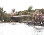
Ferry Street Bridge Ferry Street Bridge (Eugene, Oregon) The Ferry Street Bridge is a bridge that spans the Willamette River in Eugene, Oregon, United States. It is located near downtown Eugene, where the city's founder Eugene Skinner once operated a ferry service. The bridge is at Willamette river mile 182.2, and is a block west of the north terminus... |
Coburg Road Ruth Bascom Bike Path |
Eugene Eugene, Oregon Eugene is the second largest city in the U.S. state of Oregon and the seat of Lane County. It is located at the south end of the Willamette Valley, at the confluence of the McKenzie and Willamette rivers, about east of the Oregon Coast.As of the 2010 U.S... |
182.2 | 1950 | 44.05794°N 123.08391°W |
 |
Peter DeFazio Peter DeFazio Peter Anthony DeFazio is the U.S. Representative for , serving since 1987. He is a member of the Democratic Party. The district includes Eugene, Springfield, Roseburg and part of Corvallis. As Oregon's most senior member of Congress, he is the dean of Oregon's House of Representatives delegation... Bicycle Bridge |
Eugene Eugene, Oregon Eugene is the second largest city in the U.S. state of Oregon and the seat of Lane County. It is located at the south end of the Willamette Valley, at the confluence of the McKenzie and Willamette rivers, about east of the Oregon Coast.As of the 2010 U.S... |
182.35 | 2000 | 44.05691°N 123.08352°W | |
| |
Dave and Lynn Frohnmayer David B. Frohnmayer Dave Frohnmayer was the 15th President of the University of Oregon. He was appointed president on July 1, 1994. His last day as president was June 30, 2009. His tenure as president is the second-longest after John Wesley Johnson. He is the first native of the U.S. state of Oregon to run the... Pedestrian and Bicycle Bridge |
Eugene Eugene, Oregon Eugene is the second largest city in the U.S. state of Oregon and the seat of Lane County. It is located at the south end of the Willamette Valley, at the confluence of the McKenzie and Willamette rivers, about east of the Oregon Coast.As of the 2010 U.S... |
182.7 | 1970 | 44.05160°N 123.07127°W | |
| |
Knickerbocker Bicycle Bridge | Eugene Eugene, Oregon Eugene is the second largest city in the U.S. state of Oregon and the seat of Lane County. It is located at the south end of the Willamette Valley, at the confluence of the McKenzie and Willamette rivers, about east of the Oregon Coast.As of the 2010 U.S... |
183.8 | 1978 | 44.04529°N 123.05214°W | |
| |
I-5 southbound bridge | Interstate 5 Interstate 5 in Oregon In the U.S. state of Oregon, Interstate 5 traverses the state from north to south, passing through the major cities of Portland, Salem, Eugene, and Medford.-Route description:... |
Eugene Eugene, Oregon Eugene is the second largest city in the U.S. state of Oregon and the seat of Lane County. It is located at the south end of the Willamette Valley, at the confluence of the McKenzie and Willamette rivers, about east of the Oregon Coast.As of the 2010 U.S... |
183.91 | 2011 | 44.04540°N 123.05010°W |
| |
I-5 temporary detour bridge (being dismantled) | Eugene Eugene, Oregon Eugene is the second largest city in the U.S. state of Oregon and the seat of Lane County. It is located at the south end of the Willamette Valley, at the confluence of the McKenzie and Willamette rivers, about east of the Oregon Coast.As of the 2010 U.S... |
183.92 | 2004 | 44.04550°N 123.04958°W | |
| |
Springfield Bridge (north span) | Main St.  OR 126 westbound OR 126 westbound |
Springfield Springfield, Oregon Springfield is a city in Lane County, Oregon, United States. Located in the Southern Willamette Valley, it is within the Eugene-Springfield Metropolitan Statistical Area. Separated from Eugene to the west, mainly by Interstate 5, Springfield is the second-most populous city in the metropolitan area... |
185.25 | 1950 | 44.04544°N 123.02743°W |
| |
Springfield Bridge (south span) | S. "A" St. OR 126 eastbound |
Springfield Springfield, Oregon Springfield is a city in Lane County, Oregon, United States. Located in the Southern Willamette Valley, it is within the Eugene-Springfield Metropolitan Statistical Area. Separated from Eugene to the west, mainly by Interstate 5, Springfield is the second-most populous city in the metropolitan area... |
185.3 | 44.04511°N 123.02718°W | |
| |
Southern Pacific Rail bridge | Union Pacific Railroad Union Pacific Railroad The Union Pacific Railroad , headquartered in Omaha, Nebraska, is the largest railroad network in the United States. James R. Young is president, CEO and Chairman.... Amtrak Amtrak The National Railroad Passenger Corporation, doing business as Amtrak , is a government-owned corporation that was organized on May 1, 1971, to provide intercity passenger train service in the United States. "Amtrak" is a portmanteau of the words "America" and "track". It is headquartered at Union... |
Springfield Springfield, Oregon Springfield is a city in Lane County, Oregon, United States. Located in the Southern Willamette Valley, it is within the Eugene-Springfield Metropolitan Statistical Area. Separated from Eugene to the west, mainly by Interstate 5, Springfield is the second-most populous city in the metropolitan area... |
185.4 | 1891 | 44.04308°N 123.02615°W |
The river's "source" is at the confluence of the Middle Fork Willamette River
Middle Fork Willamette River
The Middle Fork Willamette River is one of several forks that unite to form the Willamette River in the western part of the U.S. state of Oregon...
and Coast Fork Willamette River
Coast Fork Willamette River
The Coast Fork Willamette River is one of several forks that unite to form the Willamette River in western Oregon in the United States. It is about long, draining an area of the mountains at the south end of the Willamette Valley south of Eugene.-Course:...
at 44.023318°N 123.023897°W