

Forest Grove, Oregon
Encyclopedia
Forest Grove is a city in Washington County
, Oregon
, United States
, 25 miles (40 km) west of Portland
. Originally a small farm town, it is now primarily a bedroom suburb
of Portland. Settled in the 1840s, the town was platted in 1850 and then incorporated in 1872 and was the first city in Washington County. The population was 21,083 at the 2010 census, an increase of 19.1% from the 2000 census (17,708).
Located in the Tualatin Valley
, Oregon routes 8, and 47 pass through Forest Grove with 47 and 8 signed as the Tualatin Valley Highway
south and east of the main part of the city, respectively, Oregon Route 8 signed as Gales Creek Road west of the city, and Oregon Route 47 signed as the Nehalem Highway north of the city. Pacific University
has been the most distinctive aspect of the town throughout its history. Old College Hall on campus is listed on the National Register of Historic Places
along with nine other structures in the city. Local employers include the university as well as Tuality Forest Grove Hospital
and Merix Corporation
.
band of the Kalapuya Native American tribe lived on the Tualatin Plains
in what is now Forest Grove. In 1841, Alvin T. and Abigail Smith were among the earliest to use the Oregon Trail
and settled on what was first known as West Tualatin Plain. They overwintered with Henry Harmon Spalding, arriving in what is now Forest Grove in the fall. Intending to be missionaries, they found little potential as most of the natives had succumbed to European diseases. Smith served as the community's first postmaster beginning on February 1, 1850, and his log cabin served as the post office.
 According to Oregon Geographic Names
, the name Forest Grove was selected on January 10, 1851, at a meeting of the trustees of Tualatin Academy
(later known as Pacific University). Resident and school trustee J. Quinn Thornton suggested the name, which he also had used for the name of his homestead. The name referred to a grove of oak trees that still stand on what is now the campus of the university. Previous post offices in the area were called Tuality Plains and Tualatin, with Forest Grove adopted on December 31, 1858. The city was platted in 1850.
In 1860, the population reached 430, but declined to 396 in 1870. Forest Grove was incorporated by the state in 1872, the first in the county. In 1880, the now Chemawa Indian School
opened in the city to train Native Americans, but moved to Salem in 1884. The population reached nearly 1,300 in 1900.
In November 1908, the Oregon Electric Railway
(OE) began serving the city, and in January 1914, competitor Southern Pacific (SP) followed suit, opening its own line, separate from OE's. Both railroads provided freight and passenger service, SP's passenger service being known as the Red Electric
. A company called the Forest Grove Transportation Company operated local streetcar service, but this lasted only from 1906–11. The Red Electric passenger service to Forest Grove ended in 1929 and Oregon Electric's ceased in 1932.
There are ten buildings on the National Register of Historic Places
and an entire 18 block district (Clark District) with homes dating as far back as 1854, and several dozen pre-1900. These include the Alvin T. Smith House
, First Church of Christ, Scientist
, and Old College Hall.
In the 1990s, filming for the television show, Nowhere Man
, took place in Forest Grove numerous times.
.
According to the United States Census Bureau
, the city has a total area of 4.7 square miles (12.2 km²), of which, 4.6 square miles (11.9 km²) of it is land and 0.1 square mile (0.258998811 km²) of it (2.75%) is water.
One of the largest giant sequoia trees of the state of Oregon can be found in Forest Grove.
of 2000, there were 17,708 people, 6,336 households, and 4,131 families residing in the city. The population density
was 3,850.5 people per square mile (1,486.3/km²). There were 6,702 housing units at an average density of 1,457.3 per square mile (562.5/km²). The racial makeup of the city was 81.46% White, 0.43% African American, 0.89% Native American, 2.11% Asian, 0.24% Pacific Islander, 11.39% from other races
, and 3.47% from two or more races. Hispanic or Latino of any race were 17.31% of the population.
There are 6,336 households out of which 35.9% had children under the age of 18 living with them, 50.3% were married couples
living together, 10.2% had a female householder with no husband present, and 34.8% were non-families. 27.9% of all households were made up of individuals and 14.3% had someone living alone who was 65 years of age or older. The average household size was 2.64 and the average family size was 3.24.
In the city the population was spread out with 27.4% under the age of 18, 13.4% from 18 to 24, 28.7% from 25 to 44, 16.8% from 45 to 64, and 13.6% who were 65 years of age or older. The median age was 31 years. For every 100 females there were 90.2 males. For every 100 females age 18 and over, there were 86.6 males.
The median income for a household in the city was $40,135, and the median income for a family was $47,733. Males had a median income of $36,139 versus $25,703 for females. The per capita income
for the city was $16,992. About 10.4% of families and 14.3% of the population were below the poverty line, including 16.2% of those under age 18 and 11.4% of those age 65 or over.
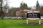 The principal landmark of Forest Grove is Pacific University
, a private school of higher education. Its significant buildings include Old College Hall and Marsh Hall.
Forest Grove, as well as Cornelius
, Gales Creek
, and Dilley
, are all part of the Forest Grove School District
.
, and public transit
service is provided by TriMet's bus
line 57-TV Highway/Forest Grove, which operates seven days a week. Line 57 connects the city with Hillsboro
and Beaverton
, via the Tualatin Valley Highway
, and links Forest Grove with the Portland region
's light rail system (MAX) in Hillsboro. Yamhill County Transit Area (YCTA) bus line 33-Hillsboro/MAX also stops in Forest Grove weekdays, at the intersection of Pacific Avenue & Highway 47 (Quince Street), and runs from Hillsboro to Gaston
, Cove Orchard, Yamhill
, Carlton
& McMinnville
via Highway 47, where riders can transfer to other YCTA buses running throughout Yamhill County
.
, Japan
Washington County, Oregon
- Major highways :* Interstate 5* Interstate 205* U.S. Route 26* Oregon Route 6* Oregon Route 8* Oregon Route 10* Oregon Route 47* Oregon Route 99W* Oregon Route 210* Oregon Route 217* Oregon Route 219-Demographics:...
, Oregon
Oregon
Oregon is a state in the Pacific Northwest region of the United States. It is located on the Pacific coast, with Washington to the north, California to the south, Nevada on the southeast and Idaho to the east. The Columbia and Snake rivers delineate much of Oregon's northern and eastern...
, United States
United States
The United States of America is a federal constitutional republic comprising fifty states and a federal district...
, 25 miles (40 km) west of Portland
Portland, Oregon
Portland is a city located in the Pacific Northwest, near the confluence of the Willamette and Columbia rivers in the U.S. state of Oregon. As of the 2010 Census, it had a population of 583,776, making it the 29th most populous city in the United States...
. Originally a small farm town, it is now primarily a bedroom suburb
Commuter town
A commuter town is an urban community that is primarily residential, from which most of the workforce commutes out to earn their livelihood. Many commuter towns act as suburbs of a nearby metropolis that workers travel to daily, and many suburbs are commuter towns...
of Portland. Settled in the 1840s, the town was platted in 1850 and then incorporated in 1872 and was the first city in Washington County. The population was 21,083 at the 2010 census, an increase of 19.1% from the 2000 census (17,708).
Located in the Tualatin Valley
Tualatin Valley
The Tualatin Valley is a farming and suburban region southwest of Portland, Oregon in the United States. The valley is formed by the meandering Tualatin River, a tributary of the Willamette River at the northwest corner of the Willamette Valley, east of the Northern Oregon Coast Range...
, Oregon routes 8, and 47 pass through Forest Grove with 47 and 8 signed as the Tualatin Valley Highway
Tualatin Valley Highway
The Tualatin Valley Highway No. 29 is an Oregon highway which passes through the Tualatin Valley, between the cities of McMinnville and Beaverton...
south and east of the main part of the city, respectively, Oregon Route 8 signed as Gales Creek Road west of the city, and Oregon Route 47 signed as the Nehalem Highway north of the city. Pacific University
Pacific University
Pacific University is a private university located in Oregon, United States. The first campus began more than 160 years ago and is located about 38 km west of Portland in Forest Grove...
has been the most distinctive aspect of the town throughout its history. Old College Hall on campus is listed on the National Register of Historic Places
National Register of Historic Places
The National Register of Historic Places is the United States government's official list of districts, sites, buildings, structures, and objects deemed worthy of preservation...
along with nine other structures in the city. Local employers include the university as well as Tuality Forest Grove Hospital
Tuality Forest Grove Hospital
Tuality Forest Grove Hospital is a 48 bed general care hospital in Forest Grove, Oregon, United States. Built in 1963, the facility employees approximately 100 healthcare professionals.-History:...
and Merix Corporation
Merix Corporation
Merix Corporation is a printed circuit board manufacturer based in the U.S. state of Oregon. Prior to a merger in 2010 with Viasystems, the Beaverton based company had been the 31st largest public company in Oregon based on market capitalization as of 2006...
.
History
Prior to the 1840s when Euro-Americans settled the area, the AtfalatiAtfalati
The Atfalati, also known as the Tualatin were a tribe or band of the Kalapuya Native Americans who originally inhabited the Tualatin Valley in the northwest part of the U.S. state of Oregon...
band of the Kalapuya Native American tribe lived on the Tualatin Plains
Tualatin Plains
The Tualatin Plains are a prairie area in central Washington County, Oregon, United States. Located around the Hillsboro and Forest Grove areas, the plains were first inhabited by the Atfalati band of the Kalapuya group of Native Americans. Euro-American settlement began in the...
in what is now Forest Grove. In 1841, Alvin T. and Abigail Smith were among the earliest to use the Oregon Trail
Oregon Trail
The Oregon Trail is a historic east-west wagon route that connected the Missouri River to valleys in Oregon and locations in between.After 1840 steam-powered riverboats and steamboats traversing up and down the Ohio, Mississippi and Missouri rivers sped settlement and development in the flat...
and settled on what was first known as West Tualatin Plain. They overwintered with Henry Harmon Spalding, arriving in what is now Forest Grove in the fall. Intending to be missionaries, they found little potential as most of the natives had succumbed to European diseases. Smith served as the community's first postmaster beginning on February 1, 1850, and his log cabin served as the post office.
Oregon Geographic Names
Oregon Geographic Names is an authoritative compilation of the origin and meaning of place names in the U.S. state of Oregon. , the book is in its seventh edition and is compiled and edited by Lewis L. McArthur, who took over from his father, Lewis A. McArthur, as of the fourth edition...
, the name Forest Grove was selected on January 10, 1851, at a meeting of the trustees of Tualatin Academy
Tualatin Academy
Tualatin Academy was a secondary school in the U.S. state of Oregon that eventually became Pacific University. Tualatin Academy also refers to the National Register of Historic Places-listed college building constructed in 1850 to house the academy, also known as Old College Hall...
(later known as Pacific University). Resident and school trustee J. Quinn Thornton suggested the name, which he also had used for the name of his homestead. The name referred to a grove of oak trees that still stand on what is now the campus of the university. Previous post offices in the area were called Tuality Plains and Tualatin, with Forest Grove adopted on December 31, 1858. The city was platted in 1850.
In 1860, the population reached 430, but declined to 396 in 1870. Forest Grove was incorporated by the state in 1872, the first in the county. In 1880, the now Chemawa Indian School
Chemawa Indian School
Chemawa Indian School is a Native American boarding school in Salem, Oregon, United States. It was opened on February 25, 1880 as an elementary school, but as of 2005, served ninth through twelfth grades. It is sometimes referred to as Chemawa High School...
opened in the city to train Native Americans, but moved to Salem in 1884. The population reached nearly 1,300 in 1900.
In November 1908, the Oregon Electric Railway
Oregon Electric Railway
The Oregon Electric Railway was an interurban railroad line in the U.S. state of Oregon that linked Portland to Eugene. Service from Portland to Salem, Oregon, began in 1907. The Spokane, Portland and Seattle Railway purchased the system in 1910, and extended service to Eugene in 1912...
(OE) began serving the city, and in January 1914, competitor Southern Pacific (SP) followed suit, opening its own line, separate from OE's. Both railroads provided freight and passenger service, SP's passenger service being known as the Red Electric
Red Electric
The Red Electric was an interurban passenger train service operated by the Southern Pacific Railroad in the Willamette Valley of the U.S. state of Oregon from 1914 to 1929. The service got its name from the bright red color of its cars. Despite its short history, among West Coast interurbans it was...
. A company called the Forest Grove Transportation Company operated local streetcar service, but this lasted only from 1906–11. The Red Electric passenger service to Forest Grove ended in 1929 and Oregon Electric's ceased in 1932.
There are ten buildings on the National Register of Historic Places
National Register of Historic Places
The National Register of Historic Places is the United States government's official list of districts, sites, buildings, structures, and objects deemed worthy of preservation...
and an entire 18 block district (Clark District) with homes dating as far back as 1854, and several dozen pre-1900. These include the Alvin T. Smith House
Alvin T. Smith House
The Alvin T. Smith House is a two-story home on Elm Street in Forest Grove, Oregon, United States. Completed in 1856, it is the second oldest building in the city and was added to the National Register of Historic Places in 1974. A Greek Revival style house, it was built by pioneer Alvin T...
, First Church of Christ, Scientist
First Church of Christ, Scientist (Forest Grove, Oregon)
The former First Church of Christ, Scientist, located at 1904 Pacific Avenue in Forest Grove, Oregon, in the United States is an historic Christian Science church built in 1916. It was designed by Spencer S. Beman, son of the noted designer of Christian Science churches, Solon Spencer Beman who had...
, and Old College Hall.
In the 1990s, filming for the television show, Nowhere Man
Nowhere Man (TV series)
Nowhere Man is an American television series that aired from 1995 to 1996 starring Bruce Greenwood. Created by Lawrence Hertzog, the series aired Monday nights on UPN. Despite critical acclaim, including TV Guides label of "The season's coolest hit," the show was cancelled after only one...
, took place in Forest Grove numerous times.
Geography
Forest Grove is located at 45°31′17"N 123°6′32"W (45.521372, -123.108759). It is on the western edge of the Portland metropolitan area and the Willamette ValleyWillamette Valley
The Willamette Valley is the most populated region in the state of Oregon of the United States. Located in the state's northwest, the region is surrounded by tall mountain ranges to the east, west and south and the valley's floor is broad, flat and fertile because of Ice Age conditions...
.
According to the United States Census Bureau
United States Census Bureau
The United States Census Bureau is the government agency that is responsible for the United States Census. It also gathers other national demographic and economic data...
, the city has a total area of 4.7 square miles (12.2 km²), of which, 4.6 square miles (11.9 km²) of it is land and 0.1 square mile (0.258998811 km²) of it (2.75%) is water.
One of the largest giant sequoia trees of the state of Oregon can be found in Forest Grove.
Demographics
As of the censusCensus
A census is the procedure of systematically acquiring and recording information about the members of a given population. It is a regularly occurring and official count of a particular population. The term is used mostly in connection with national population and housing censuses; other common...
of 2000, there were 17,708 people, 6,336 households, and 4,131 families residing in the city. The population density
Population density
Population density is a measurement of population per unit area or unit volume. It is frequently applied to living organisms, and particularly to humans...
was 3,850.5 people per square mile (1,486.3/km²). There were 6,702 housing units at an average density of 1,457.3 per square mile (562.5/km²). The racial makeup of the city was 81.46% White, 0.43% African American, 0.89% Native American, 2.11% Asian, 0.24% Pacific Islander, 11.39% from other races
Race (United States Census)
Race and ethnicity in the United States Census, as defined by the Federal Office of Management and Budget and the United States Census Bureau, are self-identification data items in which residents choose the race or races with which they most closely identify, and indicate whether or not they are...
, and 3.47% from two or more races. Hispanic or Latino of any race were 17.31% of the population.
There are 6,336 households out of which 35.9% had children under the age of 18 living with them, 50.3% were married couples
Marriage
Marriage is a social union or legal contract between people that creates kinship. It is an institution in which interpersonal relationships, usually intimate and sexual, are acknowledged in a variety of ways, depending on the culture or subculture in which it is found...
living together, 10.2% had a female householder with no husband present, and 34.8% were non-families. 27.9% of all households were made up of individuals and 14.3% had someone living alone who was 65 years of age or older. The average household size was 2.64 and the average family size was 3.24.
In the city the population was spread out with 27.4% under the age of 18, 13.4% from 18 to 24, 28.7% from 25 to 44, 16.8% from 45 to 64, and 13.6% who were 65 years of age or older. The median age was 31 years. For every 100 females there were 90.2 males. For every 100 females age 18 and over, there were 86.6 males.
The median income for a household in the city was $40,135, and the median income for a family was $47,733. Males had a median income of $36,139 versus $25,703 for females. The per capita income
Per capita income
Per capita income or income per person is a measure of mean income within an economic aggregate, such as a country or city. It is calculated by taking a measure of all sources of income in the aggregate and dividing it by the total population...
for the city was $16,992. About 10.4% of families and 14.3% of the population were below the poverty line, including 16.2% of those under age 18 and 11.4% of those age 65 or over.
Education
Pacific University
Pacific University is a private university located in Oregon, United States. The first campus began more than 160 years ago and is located about 38 km west of Portland in Forest Grove...
, a private school of higher education. Its significant buildings include Old College Hall and Marsh Hall.
Forest Grove, as well as Cornelius
Cornelius, Oregon
Cornelius is a city in Washington County, Oregon, United States. The population was 9,652 at the 2000 census. The 2007 estimate is 10,895 residents.-Geography:According to the United States Census Bureau, the city has a total area of , all of it land....
, Gales Creek
Gales Creek, Oregon
Gales Creek is an unincorporated community in Washington County, Oregon, United States on Oregon Route 8 northwest of Forest Grove in the foothills of the Oregon Coast Range....
, and Dilley
Dilley, Oregon
Dilley is an unincorporated community in Washington County, Oregon, United States. It is located south of Forest Grove and north of the city of Gaston on Oregon Route 47 in the Portland metropolitan area. Settled in the late 1840s, the community was platted in 1874 after the arrival of the railroad...
, are all part of the Forest Grove School District
Forest Grove School District
Forest Grove School District is a public school district in Washington County, Oregon, United States. It serves the communities of Cornelius, Dilley, Forest Grove and Gales Creek. Yvonne Curtis is the superintendent of the district...
.
Public transportation
Forest Grove is within the TriMet districtTriMet
TriMet, more formally known as the Tri-County Metropolitan Transportation District of Oregon, is a public agency that operates mass transit in a region that spans most of the Portland metropolitan area in the U.S. state of Oregon...
, and public transit
Public transport
Public transport is a shared passenger transportation service which is available for use by the general public, as distinct from modes such as taxicab, car pooling or hired buses which are not shared by strangers without private arrangement.Public transport modes include buses, trolleybuses, trams...
service is provided by TriMet's bus
Transit bus
A transit bus , also known as a commuter bus, city bus, or public bus, is a bus used for short-distance public transport purposes...
line 57-TV Highway/Forest Grove, which operates seven days a week. Line 57 connects the city with Hillsboro
Hillsboro, Oregon
Hillsboro is the fifth-largest city in the U.S. state of Oregon and is the county seat of Washington County. Lying in the Tualatin Valley on the west side of the Portland metropolitan area, the city is home to many high-technology companies, such as Intel, that compose what has become known as the...
and Beaverton
Beaverton, Oregon
Beaverton is a city in Washington County, Oregon, United States, seven miles west of Portland in the Tualatin River Valley.As of the 2010 census, the population is 90,267. This makes it the second-largest city in the county and Oregon's sixth-largest city...
, via the Tualatin Valley Highway
Tualatin Valley Highway
The Tualatin Valley Highway No. 29 is an Oregon highway which passes through the Tualatin Valley, between the cities of McMinnville and Beaverton...
, and links Forest Grove with the Portland region
Portland metropolitan area
The Portland-Vancouver-Hillsboro, OR-WA Metropolitan Statistical Area , also known as the Portland metropolitan area or Greater Portland, is an urban area in the U.S. states of Oregon and Washington centered around the city of Portland, Oregon. The U.S...
's light rail system (MAX) in Hillsboro. Yamhill County Transit Area (YCTA) bus line 33-Hillsboro/MAX also stops in Forest Grove weekdays, at the intersection of Pacific Avenue & Highway 47 (Quince Street), and runs from Hillsboro to Gaston
Gaston, Oregon
Gaston is a city in Washington County, Oregon, United States. The population was 600 at the 2000 census. The 2006 estimate is 630 residents.-Early history:...
, Cove Orchard, Yamhill
Yamhill, Oregon
Yamhill is a city in Yamhill County, Oregon, United States. Located in the northern part of the county, it is situated at the intersection of Oregon Route 47 and Oregon Route 240. The population was 794 at the 2000 census. The 2008 estimate is 855 residents...
, Carlton
Carlton, Oregon
Carlton is a city in Yamhill County, Oregon, United States. According to the 2000 United States Census, the municipality population was 1,514. The 2007 estimate is 1,755 residents.-History:...
& McMinnville
McMinnville, Oregon
McMinnville is the county seat and largest city of Yamhill County, Oregon, United States. According to Oregon Geographic Names, it was named by its founder, William T. Newby , an early immigrant on the Oregon Trail, for his hometown of McMinnville, Tennessee...
via Highway 47, where riders can transfer to other YCTA buses running throughout Yamhill County
Yamhill County, Oregon
-National protected areas:*Siuslaw National Forest *Tualatin River National Wildlife Refuge -Demographics:As of the census of 2000, there were 84,992 people, 28,732 households, and 21,376 families residing in the county. The population density was 119 people per square mile . There were 30,270...
.
Sister cities
Forest Grove has one sister city, located in Japan: NyuzenNyuzen, Toyama
is a town located in Shimoniikawa District, in north-eastern Toyama Prefecture, Japan.With the Sea of Japan to the north, and Kurobe River to the west Nyūzen is located in the center of an alluvial fan. The town is famous for its , as well as its tulips which became the official in...
, Japan
Japan
Japan is an island nation in East Asia. Located in the Pacific Ocean, it lies to the east of the Sea of Japan, China, North Korea, South Korea and Russia, stretching from the Sea of Okhotsk in the north to the East China Sea and Taiwan in the south...
Notable people
- Tabitha BrownTabitha BrownTabitha Moffatt Brown was an American pioneer emigrant who traveled the Oregon Trail to the Oregon Country. There she assisted in the founding of Tualatin Academy, which would grow to become Pacific University in Forest Grove, Oregon...
- Joseph Conrad ChamberlinJoseph Conrad ChamberlinJoseph Conrad Chamberlin was an American arachnologist who studied mainly pseudoscorpions. A native of Utah, he studied primarily at Stanford University while working most of his career in Oregon for the U.S. Department of Agriculture...
- Bobby ChouinardBobby ChouinardRobert William Chouinard is a retired Major League Baseball right-handed pitcher. He is the only person born in The Philippines to play Major League Baseball....
- Harvey L. ClarkHarvey L. ClarkHarvey L. Clark was an educator, missionary, and settler of what became Forest Grove, Oregon, United States. A native of Vermont, he moved to Oregon Country where he participated at the Champoeg Meetings and helped to found Tualatin Academy that later became Pacific University...
- Sara TucholskySara TucholskySara Tucholsky is an American college softball player who played for Western Oregon University, who gained national attention when she was assisted in scoring a home run by members of the opposing team, when an injury prevented her from completing the play by running the bases on her own.In 2008,...