
Nestucca River
Encyclopedia
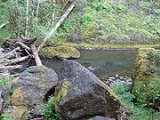
The Nestucca River flows for about 50 miles (80.5 km) through forests near the Pacific
coast of northwest Oregon
in the United States
. It drains a timber-producing area of the Northern Oregon Coast Range
west of Portland
.
Rising in the mountains of western Yamhill County
, it is impounded near its headwaters to create McGuire Reservoir, the primary water source for the city of McMinnville
. The river flows generally west through Bureau of Land Management
(BLM) land and the Siuslaw National Forest
, past Beaver
, then southwest past Hebo
and Cloverdale
. It enters Nestucca Bay
, on the Pacific Ocean
, from the north at Pacific City
. The Little Nestucca River
does not join the Nestucca but enters Nestucca Bay from the south.
, fall chinook, cutthroat trout
, and steelhead
. Although coho salmon
also frequent the river, it is illegal to catch and keep them because they are protected by the Endangered Species Act
. Winter steelhead on this river average 10 to 14 lb (4.5 to 6.4 kg), while summer steelhead of 4 to 7 lb (1.8 to 3.2 kg) can sometimes appear "almost nose to tail throughout a 20 miles (32.2 km) section of the river".
Bank access to the lower river is limited because much of the land is privately owned, but the stream, which is 50 to 100 ft (15.2 to 30.5 m) wide on the lower reaches, is often fished from boats. Cloverdale, Farmer Creek, Three Rivers, and Pacific City have public boat ramps, and there are less formal put-in places upriver. Upstream of Moon Creek, more than half of the land along the river is publicly owned, is managed by the Siuslaw National Forest and the BLM, and includes five campgrounds. The upper river between Moon Creek and Elk Creek is fished mainly for winter steelhead, and no fishing is allowed upstream of Elk Creek.
An 8 miles (12.9 km) stretch of the upper river between Rocky Bend Campground and Blaine offers whitewater
canoeing and kayak
ing possibilities when the flow is about 1000 cuft/s. The first 2 miles (3 km) of the run include a class 4
rapid followed by a class 5 and another class 4. An alternate put-in is available at a log bridge downstream of the second class 4. Below the bridge, class 2 and 3 whitewater continues for the remaining 6 miles (10 km) of the run.
Pacific Ocean
The Pacific Ocean is the largest of the Earth's oceanic divisions. It extends from the Arctic in the north to the Southern Ocean in the south, bounded by Asia and Australia in the west, and the Americas in the east.At 165.2 million square kilometres in area, this largest division of the World...
coast of northwest Oregon
Oregon
Oregon is a state in the Pacific Northwest region of the United States. It is located on the Pacific coast, with Washington to the north, California to the south, Nevada on the southeast and Idaho to the east. The Columbia and Snake rivers delineate much of Oregon's northern and eastern...
in the United States
United States
The United States of America is a federal constitutional republic comprising fifty states and a federal district...
. It drains a timber-producing area of the Northern Oregon Coast Range
Northern Oregon Coast Range
The Northern Oregon Coast Range is the northern section of the Oregon Coast Range, in the Pacific Coast Ranges physiographic region, located in the northwest portion of the state of Oregon, United States. This section of the mountain range, part of the Pacific Coast Ranges, contains peaks as high...
west of Portland
Portland, Oregon
Portland is a city located in the Pacific Northwest, near the confluence of the Willamette and Columbia rivers in the U.S. state of Oregon. As of the 2010 Census, it had a population of 583,776, making it the 29th most populous city in the United States...
.
Rising in the mountains of western Yamhill County
Yamhill County, Oregon
-National protected areas:*Siuslaw National Forest *Tualatin River National Wildlife Refuge -Demographics:As of the census of 2000, there were 84,992 people, 28,732 households, and 21,376 families residing in the county. The population density was 119 people per square mile . There were 30,270...
, it is impounded near its headwaters to create McGuire Reservoir, the primary water source for the city of McMinnville
McMinnville, Oregon
McMinnville is the county seat and largest city of Yamhill County, Oregon, United States. According to Oregon Geographic Names, it was named by its founder, William T. Newby , an early immigrant on the Oregon Trail, for his hometown of McMinnville, Tennessee...
. The river flows generally west through Bureau of Land Management
Bureau of Land Management
The Bureau of Land Management is an agency within the United States Department of the Interior which administers America's public lands, totaling approximately , or one-eighth of the landmass of the country. The BLM also manages of subsurface mineral estate underlying federal, state and private...
(BLM) land and the Siuslaw National Forest
Siuslaw National Forest
Siuslaw National Forest is a national forest in western Oregon, United States. Established in 1908, the Siuslaw is made up of a wide variety of ecosystems, ranging from coastal forests to sand dunes.- Geography :...
, past Beaver
Beaver, Oregon
Beaver is an unincorporated community in Tillamook County, Oregon, United States, located on U.S. Route 101 and the Nestucca River, about 12 miles south of Tillamook. For statistical purposes, the United States Census Bureau has defined Beaver as a census-designated place...
, then southwest past Hebo
Hebo, Oregon
Hebo is an unincorporated community in Tillamook County, Oregon, United States. For statistical purposes, the United States Census Bureau has defined Hebo as a census-designated place . The census definition of the area may not precisely correspond to local understanding of the area with the same...
and Cloverdale
Cloverdale, Oregon
Cloverdale, Oregon may refer to:*Cloverdale, Oregon *Cloverdale, Deschutes County, Oregon *Cloverdale, Lane County, Oregon...
. It enters Nestucca Bay
Nestucca Bay
Nestucca Bay is a small S-shaped inlet of the Pacific Ocean located in northwest Oregon in the United States. It is located near the town of Pacific City in southwestern Tillamook County, approximately 12 mi south of Cape Lookout. The Nestucca and Little Nestucca rivers enter the bay from the...
, on the Pacific Ocean
Pacific Ocean
The Pacific Ocean is the largest of the Earth's oceanic divisions. It extends from the Arctic in the north to the Southern Ocean in the south, bounded by Asia and Australia in the west, and the Americas in the east.At 165.2 million square kilometres in area, this largest division of the World...
, from the north at Pacific City
Pacific City, Oregon
Pacific City is a census-designated place and unincorporated community in Tillamook County, Oregon, United States. The population was 1,027 at the 2000 census...
. The Little Nestucca River
Little Nestucca River
The Little Nestucca River is a river, approximately 20 mi long, on the Pacific coast of northwest Oregon in the United States. It drains an area of the Central Oregon Coast Range west of the Willamette Valley....
does not join the Nestucca but enters Nestucca Bay from the south.
Recreation
Madelynne Sheehan in Fishing in Oregon calls the Nestucca River "a real gem of an all-around stream." Anglers can fish for spring chinook salmonChinook salmon
The Chinook salmon, Oncorhynchus tshawytscha, is the largest species in the pacific salmon family. Other commonly used names for the species include King salmon, Quinnat salmon, Spring salmon and Tyee salmon...
, fall chinook, cutthroat trout
Cutthroat trout
The cutthroat trout is a species of freshwater fish in the salmon family of order Salmoniformes. It is one of the many fish species colloquially known as trout...
, and steelhead
Rainbow trout
The rainbow trout is a species of salmonid native to tributaries of the Pacific Ocean in Asia and North America. The steelhead is a sea run rainbow trout usually returning to freshwater to spawn after 2 to 3 years at sea. In other words, rainbow trout and steelhead trout are the same species....
. Although coho salmon
Coho salmon
The Coho salmon, Oncorhynchus kisutch, is a species of anadromous fish in the salmon family. Coho salmon are also known as silver salmon or "silvers". It is the state animal of Chiba, Japan.-Description:...
also frequent the river, it is illegal to catch and keep them because they are protected by the Endangered Species Act
Endangered Species Act
The Endangered Species Act of 1973 is one of the dozens of United States environmental laws passed in the 1970s. Signed into law by President Richard Nixon on December 28, 1973, it was designed to protect critically imperiled species from extinction as a "consequence of economic growth and...
. Winter steelhead on this river average 10 to 14 lb (4.5 to 6.4 kg), while summer steelhead of 4 to 7 lb (1.8 to 3.2 kg) can sometimes appear "almost nose to tail throughout a 20 miles (32.2 km) section of the river".
Bank access to the lower river is limited because much of the land is privately owned, but the stream, which is 50 to 100 ft (15.2 to 30.5 m) wide on the lower reaches, is often fished from boats. Cloverdale, Farmer Creek, Three Rivers, and Pacific City have public boat ramps, and there are less formal put-in places upriver. Upstream of Moon Creek, more than half of the land along the river is publicly owned, is managed by the Siuslaw National Forest and the BLM, and includes five campgrounds. The upper river between Moon Creek and Elk Creek is fished mainly for winter steelhead, and no fishing is allowed upstream of Elk Creek.
An 8 miles (12.9 km) stretch of the upper river between Rocky Bend Campground and Blaine offers whitewater
Whitewater
Whitewater is formed in a rapid, when a river's gradient increases enough to disturb its laminar flow and create turbulence, i.e. form a bubbly, or aerated and unstable current; the frothy water appears white...
canoeing and kayak
Kayak
A kayak is a small, relatively narrow, human-powered boat primarily designed to be manually propelled by means of a double blade paddle.The traditional kayak has a covered deck and one or more cockpits, each seating one paddler...
ing possibilities when the flow is about 1000 cuft/s. The first 2 miles (3 km) of the run include a class 4
International Scale of River Difficulty
The International Scale of River Difficulty is a standardized scale used to rate the safety of a stretch of river, or a single rapid. The grade reflects the technical difficulty and skill level required associated with the section of river...
rapid followed by a class 5 and another class 4. An alternate put-in is available at a log bridge downstream of the second class 4. Below the bridge, class 2 and 3 whitewater continues for the remaining 6 miles (10 km) of the run.