
Celilo Falls
Encyclopedia

Columbia River
The Columbia River is the largest river in the Pacific Northwest region of North America. The river rises in the Rocky Mountains of British Columbia, Canada, flows northwest and then south into the U.S. state of Washington, then turns west to form most of the border between Washington and the state...
, just east of the Cascade Mountains
Cascade Range
The Cascade Range is a major mountain range of western North America, extending from southern British Columbia through Washington and Oregon to Northern California. It includes both non-volcanic mountains, such as the North Cascades, and the notable volcanoes known as the High Cascades...
, on what is today the border between the U.S. states of Oregon
Oregon
Oregon is a state in the Pacific Northwest region of the United States. It is located on the Pacific coast, with Washington to the north, California to the south, Nevada on the southeast and Idaho to the east. The Columbia and Snake rivers delineate much of Oregon's northern and eastern...
and Washington. The name refers to a series of cascades and waterfalls on the river, as well as to the native settlements and trading villages that existed there in various configurations for 15,000 years. Celilo was the oldest continuously inhabited community on the North American continent until 1957, when the falls and nearby settlements were submerged by the construction of The Dalles Dam.
Main waterfall
The main waterfall, known variously as Celilo Falls, The Chutes, Great Falls, or Columbia Falls, consisted of three sections: a cataractWaterfall
A waterfall is a place where flowing water rapidly drops in elevation as it flows over a steep region or a cliff.-Formation:Waterfalls are commonly formed when a river is young. At these times the channel is often narrow and deep. When the river courses over resistant bedrock, erosion happens...
, called Horseshoe Falls or Tumwater Falls; a deep eddy, the Cul-de-Sac; and the main channel. These features were formed by the Columbia River's relentless push through basalt
Basalt
Basalt is a common extrusive volcanic rock. It is usually grey to black and fine-grained due to rapid cooling of lava at the surface of a planet. It may be porphyritic containing larger crystals in a fine matrix, or vesicular, or frothy scoria. Unweathered basalt is black or grey...
narrows
Narrows
Narrows is a term for restricted land or water passages. Most commonly it refers to a strait, though it can also refer to a water gap....
on the final leg of its journey to the Pacific Ocean
Pacific Ocean
The Pacific Ocean is the largest of the Earth's oceanic divisions. It extends from the Arctic in the north to the Southern Ocean in the south, bounded by Asia and Australia in the west, and the Americas in the east.At 165.2 million square kilometres in area, this largest division of the World...
. Frequently more than a mile (1.6 km) in width, the river was squeezed here into a width of only 140 feet (43 m). The seasonal flow of the Columbia changed the height of the falls over the course of a year. At low water the drop was about 20 feet (6.1 m). In 1839, Modeste Demers investigated the area in some detail and described not just one fall but a great many, in different channels and with different qualities. He wrote, "The number and variety [of the channels and falls] are surprising. They are not all equally deep. The falls are from 3 to 12 and 15 feet high." During the spring freshet
Freshet
A freshet can refer to one of two things:* A flood resulting from heavy rain or a spring thaw. Whereas heavy rain often causes a flash flood, a spring thaw event is generally a more incremental process, depending upon local climate and topography...
in June and July, the falls could be completely submerged. The falls were the sixth-largest by volume in the world and were among the largest in North America. Average annual flow is about 190,000 ft³/sec (5380 m³/s), and during periods of high water or flood
Flood
A flood is an overflow of an expanse of water that submerges land. The EU Floods directive defines a flood as a temporary covering by water of land not normally covered by water...
, as much as 1,240,000 ft³/sec (35,113 m³/s) passed over the falls.
The Narrows and The Dalles
Celilo Falls itself was the first in a series of cascades and rapids known collectively as The Narrows or The Dalles, stretching for about 12 miles (19.3 km) downstream. Over that length, the river dropped 82 feet (25 m) at high water and 63 feet (19.2 m) at low water.Three miles (4.8 km) below Celilo Falls was a stretch of rapids known variously as the Short Narrows, Ten Mile Rapids, the Little (or Upper) Dalles, or Les Petites Dalles. These rapids were about 1 miles (1.6 km) long and 250 feet (76.2 m) wide. Ten miles (16 km) below Celilo Falls was another stretch of rapids, this one known as the Long Narrows, Five Mile Rapids, the Big (or Lower) Dalles, Les Grandes Dalles, or Grand Dalles. This stretch of rapids was about 3 miles (4.8 km) long, and the river channel narrowed to 75 feet (22.9 m). Immediately downstream were the Dalles Rapids (or Wascopam to the local natives), about 1.5 miles (2.4 km) long. Here the river dropped 15 feet (4.6 m) in a tumult much commented on by early explorers.
The Long Narrows and the Dalles Rapids are sometimes grouped together under names such as Grand Dalles, Les Dalles, Big Dalles, or The Dalles. One early observer, Ross Cox, noted a three-mile "succession of boiling whirlpools". Explorer Charles Wilkes
Charles Wilkes
Charles Wilkes was an American naval officer and explorer. He led the United States Exploring Expedition, 1838-1842 and commanded the ship in the Trent Affair during the American Civil War...
described it as "one of the most remarkable places upon the Columbia". He calculated that the river dropped about 50 feet (15.2 m) over 2 miles (3.2 km) here. During the spring freshet, the river rose as much as 62 feet (18.9 m), radically altering the nature of the rapids. Fur trader Alexander Ross
Alexander Ross (fur trader)
-Fur trader and explorer:Ross emigrated to Upper Canada, present day , from Scotland about 1805.In 1811, while working for John Jacob Astor's Pacific Fur Company, Ross took part in the founding of Fort Astoria, a fur-trading post at the mouth of the Columbia River...
wrote, "[The water] rushes with great impetuosity; the foaming surges dash through the rocks with terrific violence; no craft, either large or small, can venture there safely. During floods, this obstruction, or ledge of rocks, is covered with water, yet the passage of the narrows is not thereby improved."
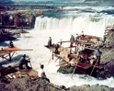
Fishing and trading
For 15,000 years, native peoplesNative Americans in the United States
Native Americans in the United States are the indigenous peoples in North America within the boundaries of the present-day continental United States, parts of Alaska, and the island state of Hawaii. They are composed of numerous, distinct tribes, states, and ethnic groups, many of which survive as...
gathered at Wyam to fish and exchange goods. They built wooden platforms out over the water and caught salmon
Salmon
Salmon is the common name for several species of fish in the family Salmonidae. Several other fish in the same family are called trout; the difference is often said to be that salmon migrate and trout are resident, but this distinction does not strictly hold true...
with dipnets and long spears on poles as the fish swam up through the rapids and jumped over the falls. Historically, an estimated fifteen to twenty million salmon passed through the falls every year, making it one of the greatest fishing sites in North America.
Celilo Falls and The Dalles were strategically located at the border between Chinookan
Chinookan languages
Chinookan is a small family of languages spoken in Oregon and Washington along the Columbia River by Chinook peoples.-Family division:Chinookan languages consists of three languages with multiple varieties. There is some dispute over classification, and there are two ISO 639-3 codes assigned: and...
and Sahaptian speaking peoples and served as the center of an extensive trading network across the Pacific Plateau. Artifacts from the original village site at Celilo suggest that trade goods came from as far away as the Great Plains
Great Plains
The Great Plains are a broad expanse of flat land, much of it covered in prairie, steppe and grassland, which lies west of the Mississippi River and east of the Rocky Mountains in the United States and Canada. This area covers parts of the U.S...
, Southwestern United States
Southwestern United States
The Southwestern United States is a region defined in different ways by different sources. Broad definitions include nearly a quarter of the United States, including Arizona, California, Colorado, Nevada, New Mexico, Oklahoma, Texas and Utah...
, and Alaska
Alaska
Alaska is the largest state in the United States by area. It is situated in the northwest extremity of the North American continent, with Canada to the east, the Arctic Ocean to the north, and the Pacific Ocean to the west and south, with Russia further west across the Bering Strait...
. When the Lewis and Clark expedition
Lewis and Clark Expedition
The Lewis and Clark Expedition, or ″Corps of Discovery Expedition" was the first transcontinental expedition to the Pacific Coast by the United States. Commissioned by President Thomas Jefferson and led by two Virginia-born veterans of Indian wars in the Ohio Valley, Meriwether Lewis and William...
passed through the area in 1805, the explorers found a "great emporium…where all the neighboring nations assemble," and a population density unlike anything they had seen on their journey. Accordingly, historians have likened the Celilo area to the “Wall Street
Wall Street
Wall Street refers to the financial district of New York City, named after and centered on the eight-block-long street running from Broadway to South Street on the East River in Lower Manhattan. Over time, the term has become a metonym for the financial markets of the United States as a whole, or...
of the West." The Wishram
Wasco-Wishram
Wasco-Wishram are two closely related Chinook Indian tribes from the Columbia River in Oregon. Today the tribes are part of the Warm Springs Reservation in Oregon and Confederated Tribes and Bands of the Yakama Nation in Washington.-History:...
people lived on the north bank, while the Wasco
Wasco-Wishram
Wasco-Wishram are two closely related Chinook Indian tribes from the Columbia River in Oregon. Today the tribes are part of the Warm Springs Reservation in Oregon and Confederated Tribes and Bands of the Yakama Nation in Washington.-History:...
lived on the south bank, with the most intense bargaining occurring at the Wishram village of Nix-luidix. Charles Wilkes reported finding three major native fishing sites on the lower Columbia — Celilo Falls, the Big Dalles, and Cascades Rapids
Cascades Rapids
The Cascades Rapids were an area of rapids along North America's Columbia River, between the U.S. states of Washington and Oregon. Through a stretch approximately wide, the river dropped about in .-Boat portage:Boat travelers were forced to either portage boats and supplies or pull boats up with...
, with the Big Dalles being the largest. Alexander Ross described it as the "great rendezvous" of native traders, as "the great emporium or mart of the Columbia." Pinniped
Pinniped
Pinnipeds or fin-footed mammals are a widely distributed and diverse group of semiaquatic marine mammals comprising the families Odobenidae , Otariidae , and Phocidae .-Overview: Pinnipeds are typically sleek-bodied and barrel-shaped...
s such as sea lions and seals followed salmon up the Columbia as far as Celilo Falls. In 1841 George Simpson
George Simpson (administrator)
Sir George Simpson was a Scots-Quebecer and employee of the Hudson's Bay Company . His title was Governor-in-Chief of Rupert's Land and administrator over the Northwest Territories and Columbia Department in British North America from 1821 to 1860.-Early years:George Simpson was born in Dingwall,...
wrote "these animals ascend the Columbia in great numbers in quest of the salmon.
Navigation
The seasonal changes in the Columbia's flow, high in summer and low in winter, affected Celilo Falls dramatically. Lewis and Clark reached Celilo Falls in the late autumn when the water was relatively low, turning the falls into a major barrier. In contrast, when David ThompsonDavid Thompson (explorer)
David Thompson was an English-Canadian fur trader, surveyor, and map-maker, known to some native peoples as "Koo-Koo-Sint" or "the Stargazer"...
passed Celilo Falls in July 1811, the high water obscured the falls and made his passage through the Columbia Gorge relatively easy. Modeste Demers wrote about the seasonal change in 1839: "One may be astonished to learn that these chutes, so terrible at low water, are smooth and still at very high water, which does not happen every year. Then it is that, instead of fearing them, the voyageurs
Voyageurs
The Voyageurs were the persons who engaged in the transportation of furs by canoe during the fur trade era. Voyageur is a French word which literally translates to "traveler"...
hasten to approach them, to light their pipes and rest." More difficult was the Long Narrows, or Big Dalles, ten miles below Celilo Falls. This section of the river was impassable during high water. During the autumn low water they were passable but with unloaded boats only, and even then the passage was very dangerous. "They are never passed without dread", wrote François Blanchet in 1839. Narcissa Whitman
Narcissa Whitman
Narcissa Prentiss Whitman was an American missionary in the Oregon Country of what would become the state of Washington. Along with Eliza Hart Spalding , she was the first European-American woman to cross the Rocky Mountains in 1836 on her way to found the Protestant Whitman Mission with husband Dr...
asserted in 1836 that over one hundred "white lives" had been lost at the Dalles.
In the 1840s and 1850s, American pioneers
American pioneer
American pioneers are any of the people in American history who migrated west to join in settling and developing new areas. The term especially refers to those who were going to settle any territory which had previously not been settled or developed by European or American society, although the...
began arriving in the area, traveling down the Columbia on wooden barges loaded with wagons. Many lost their lives in the violent currents near Celilo. In the 1870s, the Army Corps of Engineers embarked on a plan to improve navigation on the river. In 1915, they completed the 14 miles (22.5 km) Celilo Canal
Celilo Canal
Celilo Canal was a canal connecting two points of the Columbia River between the states of Oregon and Washington, U.S. just east of The Dalles....
, a portage
Portage
Portage or portaging refers to the practice of carrying watercraft or cargo over land to avoid river obstacles, or between two bodies of water. A place where this carrying occurs is also called a portage; a person doing the carrying is called a porter.The English word portage is derived from the...
allowing steamboats to circumvent the turbulent falls. Though the canal's opening was greeted with great enthusiasm and anticipation, the canal was scarcely used and was completely idle by 1919.
Flooded by the dam
As more settlers arrived in the Pacific NorthwestPacific Northwest
The Pacific Northwest is a region in northwestern North America, bounded by the Pacific Ocean to the west and, loosely, by the Rocky Mountains on the east. Definitions of the region vary and there is no commonly agreed upon boundary, even among Pacific Northwesterners. A common concept of the...
in the 1930s and 1940s, civic leaders advocated for a system of hydroelectric dams on the Columbia River. They argued that the dams would improve navigation for barge traffic from interior regions to the ocean; provide a reliable source of irrigation
Irrigation
Irrigation may be defined as the science of artificial application of water to the land or soil. It is used to assist in the growing of agricultural crops, maintenance of landscapes, and revegetation of disturbed soils in dry areas and during periods of inadequate rainfall...
for agricultural production
Agriculture
Agriculture is the cultivation of animals, plants, fungi and other life forms for food, fiber, and other products used to sustain life. Agriculture was the key implement in the rise of sedentary human civilization, whereby farming of domesticated species created food surpluses that nurtured the...
; provide electricity
Electricity
Electricity is a general term encompassing a variety of phenomena resulting from the presence and flow of electric charge. These include many easily recognizable phenomena, such as lightning, static electricity, and the flow of electrical current in an electrical wire...
for the World War II
World War II
World War II, or the Second World War , was a global conflict lasting from 1939 to 1945, involving most of the world's nations—including all of the great powers—eventually forming two opposing military alliances: the Allies and the Axis...
defense industry
United States Department of Defense
The United States Department of Defense is the U.S...
; and alleviate the flooding of downriver cities, as occurred in the 1948 destruction of Vanport City, Oregon.
Aluminum production, shipbuilding
Shipbuilding
Shipbuilding is the construction of ships and floating vessels. It normally takes place in a specialized facility known as a shipyard. Shipbuilders, also called shipwrights, follow a specialized occupation that traces its roots to before recorded history.Shipbuilding and ship repairs, both...
, and nuclear production at the Hanford site
Hanford Site
The Hanford Site is a mostly decommissioned nuclear production complex on the Columbia River in the U.S. state of Washington, operated by the United States federal government. The site has been known by many names, including Hanford Works, Hanford Engineer Works or HEW, Hanford Nuclear Reservation...
contributed to a rapid increase in regional demand for electricity. By 1943, fully 96 percent of Columbia River electricity was being used for war manufacturing. The volume of water at Celilo Falls made The Dalles an attractive site for a new dam in the eyes of the Corps of Engineers.
Throughout this period, native people continued to fish at Celilo, under the provisions of the 1855 Treaties
Walla Walla Council (1855)
The Walla Walla Council was a meeting in the Pacific Northwest between the United States and sovereign tribal bodies of the Cayuse, Nez Perce, Umatilla, Walla Walla, and Yakama. The treaties signed at this council were ratified by the U.S. Senate in 1859...
signed with the Yakama Nation, the Confederated Tribes of Warm Springs
Confederated Tribes of Warm Springs
The Confederated Tribes of Warm Springs is a federally recognized confederation of Native American Tribes who currently live on and govern the Warm Springs Indian Reservation in the U.S...
, and the Walla Walla
Walla Walla (tribe)
Walla Walla |Native American]] tribe of the northwestern United States. The reduplication of the word expresses the diminutive form. The name "Walla Walla" is translated several ways but most often as "many waters."...
, Umatilla
Umatilla (tribe)
The Umatilla are a Sahaptin-speaking Native American group living on the Umatilla Indian Reservation, who traditionally inhabited the Columbia Plateau region of the northwestern United States....
, and Cayuse
Cayuse
The Cayuse are a Native American tribe in the state of Oregon in the United States. The Cayuse tribe shares a reservation in northeastern Oregon with the Umatilla and the Walla Walla tribes as part of the Confederated Tribes of the Umatilla Indian Reservation...
, which guaranteed the tribes' ancient "right of taking fish at all usual and accustomed stations." In 1947, the federal government convened Congressional
United States Congress
The United States Congress is the bicameral legislature of the federal government of the United States, consisting of the Senate and the House of Representatives. The Congress meets in the United States Capitol in Washington, D.C....
hearings and concluded that the proposed dam at The Dalles would not violate tribal fishing rights under the treaties. Subsequently, the government reached a monetary settlement with the affected tribes, paying $26.8 million for the loss of Celilo and other fishing sites on the Columbia.
The Army Corps of Engineers commenced work on The Dalles Dam in 1952 and completed it five years later. On March 10, 1957, hundreds of observers looked on as a rising Lake Celilo
Lake Celilo
Lake Celilo is a long reservoir on the Columbia River in the United States, between the U.S. states of Washington and Oregon. It was created in 1957 with the construction of The Dalles Dam near The Dalles, Oregon, and stretches upstream to the John Day Dam. Its filling drowned the former site of...
rapidly silenced the falls, submerged fishing platforms, and consumed the village of Celilo, ending an age-old existence for those who lived there. A small Native American community exists today at nearby Celilo Village
Celilo Village, Oregon
Celilo Village, Oregon is an unincorporated Native American community on the Columbia River in northeastern Wasco County in the U.S. state of Oregon. It is near Lake Celilo, the former site of Celilo Falls; it is just south of the community of Wishram, Washington, across the Columbia River.In 2003...
, on a bluff overlooking the former location of the falls.
In 2008 the Army Corps of Engineers completed a survey of the Celilo Falls site using sonar
Sonar
Sonar is a technique that uses sound propagation to navigate, communicate with or detect other vessels...
technology, in response to the 50th anniversary of the flooding of the falls. The survey revealed that the falls remain intact below the artificial lake, and that "rocky outcrops, carved basins and channels that match aerial photographs from the 1940s."
Legacy
Celilo Falls retains great cultural significance for native peoples. Ted Strong of the Intertribal Fish Commission told one historian, "If you are an Indian person and you think, you can still see all the characteristics of that waterfall. If you listen, you can still hear its roar. If you inhale, the fragrances of mist and fish and water come back again." In 2007, three thousand people gathered at Celilo Village to commemorate the 50-year anniversary of the inundation of the falls.Artist and architect Maya Lin
Maya Lin
Maya Ying Lin is an American artist who is known for her work in sculpture and landscape art. She is the designer of the Vietnam Veterans Memorial in Washington, D.C.-Personal life:...
is working on interpretive artwork at Celilo for the Confluence Project
Confluence Project
The Confluence Project is a series of outdoor installations and interpretive artworks located in public parks along the Columbia River and its tributaries in the U.S. states of Washington and Oregon. Works underway may include both building and landscape designs as well as integrated artwork...
, scheduled for completion in 2009.
External links
- http://www.offbeatoregon.com/H1009a_celilo-falls-part-of-once-wild-Columbia.html
- Woody, Elizabeth. Recalling Celilo.
- Columbia River Inter-Tribal Fish Commission, includes Celilo Legacy commemoration and Celilo history
- Fisher, Andrew H. Tangled Nets: Treaty Rights and Tribal Identities at Celilo Falls, Oregon HIstorical Quarterly, summer 2004.
- Fredlund, Diana. The Corps of Engineers and Celilo Falls: Facing the Past, Looking to the Future, Oregon Historical Quarterly, winter 2007.
- Significant Events in the History of Celilo Falls. Oregon Historical Quarterly 108.4 (2007). Retrieved on July 7, 2008.
- Binus, Joshua. Yakama Nation & US Corps Discuss Celilo Settlement, Oregon History Project, 2004.