
Tualatin River
Encyclopedia
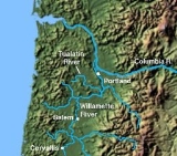
The Tualatin River is a tributary of the Willamette River
located in Oregon
in the United States
. The river is approximately 83 miles (133.6 km) long, and it drains a fertile farming region called the Tualatin Valley
southwest and west of Portland
at the northwest corner of the Willamette Valley
. There are approximately 500,000 people residing on 15 percent of the land in the river's watershed.
. It begins in the Tillamook State Forest
in Washington County and flows about 83 miles (133.6 km) to the Willamette River
near West Linn in Clackamas County. Along the way, it falls from about 2000 feet (609.6 m) above sea level
to about 60 feet (18.3 m), most of that occurring in its first 15 miles (24.1 km). From the unincorporated
community of Cherry Grove
, 68 miles (109.4 km) from the mouth, the river falls only about 220 feet (67.1 m) in meander
s that trend generally east across the relatively flat Tualatin Valley
.
From its source, the river flows south for about 1 miles (1.6 km) before turning east to parallel to Blind Cabin Ridge, which is to the river's right. Shortly thereafter, the river plunges over the 40 feet (12.2 m) Ki-a-Kuts Falls
, then receives Maple Creek from the left and then Sunday Creek, also from the left, at river mile
(RM) 76.7 (RK 123.4). Lee Creek enters from the left and Patten Creek from the right before the river reaches Hillsboro Reservoir and then Haines Falls at about RM 73 (RK 117). Hillsboro Reservoir Road and Southwest Lee Falls Road run roughly parallel to the river along its left back from the reservoir to the unincorporated
community of Cherry Grove
. Over the next stretch, the river runs roughly parallel to Hagerty Ridge, which is on the right. About 2 miles (3 km) further downstream, the river goes over Lee Falls and, shortly thereafter, Little Lee Falls before reaching Cherry Grove, which is on the river's left at the west end of Patton Valley. At Cherry Grove, the river passes under Roaring Creek Road, receives Roaring Creek from the right, passes under Bruce Road and Southwest S Road, and receives Hering Creek from the left. Thereafter, it flows under Northwest Mount Richmond Road and receives Mercer Creek from the left about 65 miles (104.6 km) from the river's mouth. Below this, Black Jack Creek enters from the left, and the river passes under Oregon Route 47 and flows by the city of Gaston
, which is to the right.
Turning north near Gaston and meandering roughly parallel to Route 47 to the west (left), the river receives Wapato Creek, which flows through the former Wapato Lake
, from the right and Scoggins Creek
, which drains Henry Hagg Lake
, from the left at RM 60 (RK 97). Soon, O'Neill Creek enters from the left, and shortly thereafter, the river passes under Southwest Spring Hill Road, then receives Dilley Creek from the left at about RM 57.5 (RK 92.5). At this point, the unincorporated community of Dilley
is on the left. At Dilley, the stream meanders east away from the highway and soon receives Carpenter Creek from the left and then Gales Creek
. Along this stretch of the river, the city of Forest Grove
is north (left) of the river. Meandering generally east, the river passes under Southwest Fern Hill Road, by the city of Cornelius
to the left and the unincorporated community of Blooming
to the right, and passes under Golf Course Road about 52 miles (83.7 km) from the mouth. Dairy Creek
enters from the left at about RM 45 (RK 72) as the river approaches Hillsboro
, which is to the river's left. Wandering through Jackson Bottom and the Jackson Bottom Wetlands Preserve
, the river passes under Oregon Route 219 (Southwest Hillsboro Highway), and soon receives Jackson Slough from the left, then Davis Creek from the right at RM 40 (RK 64).
Passing under Minter Bridge Road about 41 miles (66 km) from the mouth, and then Rood Bridge Road, the river wanders by the Meriwether National Golf Course
which is on its right and The Reserve Vineyards & Golf Club
, which is to the left, and receives Rock Creek, Gordon Creek, and Butternut Creek, all from the left. Flowing south from the vicinity of the golf course, the river runs roughly parallel to River Road, which is on its left. It passes under Harris Bridge, which carries Oregon Route 10 and Oregon Route 208 (Southwest Farmington Road) at the unincorporated community of Farmington
. Further downstream, it receives Christensen and Burris creeks from the right and continues south until turning east again at about RM 30 (RK 48). Shortly thereafter, it flows by the unincorporated community of Scholls
, where it receives McFee Creek from the right before passing under Scholls Bridge and Oregon Route 210. Entering the Tualatin River National Wildlife Refuge
at about RM 25 (RK 40).
Leaving the wildlife refuge about 4 miles (6 km) later, the rivers meanders around the unincorporated community of Bull Mountain
, which is on its left (north), passes under Roy Rogers Road, receives Chicken Creek and Rock Creek from the right, then passes under Oregon Route 99W (Southwest Pacific Highway) at King City
. The river continues by Avalon Park, which is on its left, flows through Cook Park in Tigard
, which is on its left, and forms the north boundary of the Tualatin Country Club, which is on the right. Immediately thereafter, the river receives Fanno Creek
from the left just after passing under a Portland and Western Railroad
bridge and a pedestrian bridge between Tigard and Durham
on the left (north) and Tualatin
on the right. Durham City Park is on the left bank, and Tualatin Park is on the right. The stream passes under another Portland and Western Railroad bridge, then under Southwest Boones Ferry Road and then under Interstate 5
, the latter at about RM 8 (RK 13), and enters Clackamas County.
Shortly thereafter, the river passes Browns Ferry Park, which is on the river's right, and then Canal Acres Park, on the left. At the east end of the park, Saum Creek enters from the right, and the Oswego Canal, which carries water from the Tualatin River to Oswego Lake
in Lake Oswego
, is on the left. Beyond the canal entrance, the river passes River Run Park, which is on the left. Soon Athey Creek enters from the right and Pecan Creek from the left before the river passes under Southwest Stafford Road near the unincorporated area of Wankers Corner
and flows past the unincorporated community of Shadowood
. In its final 5 miles (8 km), the river receives Wilson Creek from the right, passes under Interstate 205
and then under Southwest Borland Road, and receives Fields Creek from the left. It flows by Swift Shore Park, which is on the left, under Southwest Pete's Mountain Road, by Willamette Park, also on the left, and enters the Willamette River at West Linn
, about 28 miles (45.1 km) from the larger river's confluence with the Columbia River.
band, the Atafalati, that lived in the Tualatin river valley
. The name translated as sluggish or lazy. Early settlers called it the "Quality River".
The valley of the Tualatin was an important early farming region in the settlement of Oregon. The building of a plank road
to the Tualatin Valley from Portland
in 1856 is considered by historians to be one of the principal reasons for the rise of Portland as the dominant city in the region. The valley contains numerous natural wetland
s, some of which have been designated the Tualatin River National Wildlife Refuge
, and others are protected at Jackson Bottom Wetlands Preserve
.
Willamette River
The Willamette River is a major tributary of the Columbia River, accounting for 12 to 15 percent of the Columbia's flow. The Willamette's main stem is long, lying entirely in northwestern Oregon in the United States...
located in Oregon
Oregon
Oregon is a state in the Pacific Northwest region of the United States. It is located on the Pacific coast, with Washington to the north, California to the south, Nevada on the southeast and Idaho to the east. The Columbia and Snake rivers delineate much of Oregon's northern and eastern...
in the United States
United States
The United States of America is a federal constitutional republic comprising fifty states and a federal district...
. The river is approximately 83 miles (133.6 km) long, and it drains a fertile farming region called the Tualatin Valley
Tualatin Valley
The Tualatin Valley is a farming and suburban region southwest of Portland, Oregon in the United States. The valley is formed by the meandering Tualatin River, a tributary of the Willamette River at the northwest corner of the Willamette Valley, east of the Northern Oregon Coast Range...
southwest and west of Portland
Portland, Oregon
Portland is a city located in the Pacific Northwest, near the confluence of the Willamette and Columbia rivers in the U.S. state of Oregon. As of the 2010 Census, it had a population of 583,776, making it the 29th most populous city in the United States...
at the northwest corner of the Willamette Valley
Willamette Valley
The Willamette Valley is the most populated region in the state of Oregon of the United States. Located in the state's northwest, the region is surrounded by tall mountain ranges to the east, west and south and the valley's floor is broad, flat and fertile because of Ice Age conditions...
. There are approximately 500,000 people residing on 15 percent of the land in the river's watershed.
Course
The Tualatin River arises near Windy Point on the eastern side of the Northern Oregon Coast RangeNorthern Oregon Coast Range
The Northern Oregon Coast Range is the northern section of the Oregon Coast Range, in the Pacific Coast Ranges physiographic region, located in the northwest portion of the state of Oregon, United States. This section of the mountain range, part of the Pacific Coast Ranges, contains peaks as high...
. It begins in the Tillamook State Forest
Tillamook State Forest
The Tillamook State Forest is a publicly owned forest in the U.S. state of Oregon. Managed by the Oregon Department of Forestry, it is located west of Portland in the Northern Oregon Coast Range, and spans Washington, Tillamook, Yamhill, and Clatsop counties. The forest receives large amounts of...
in Washington County and flows about 83 miles (133.6 km) to the Willamette River
Willamette River
The Willamette River is a major tributary of the Columbia River, accounting for 12 to 15 percent of the Columbia's flow. The Willamette's main stem is long, lying entirely in northwestern Oregon in the United States...
near West Linn in Clackamas County. Along the way, it falls from about 2000 feet (609.6 m) above sea level
Sea level
Mean sea level is a measure of the average height of the ocean's surface ; used as a standard in reckoning land elevation...
to about 60 feet (18.3 m), most of that occurring in its first 15 miles (24.1 km). From the unincorporated
Unincorporated area
In law, an unincorporated area is a region of land that is not a part of any municipality.To "incorporate" in this context means to form a municipal corporation, a city, town, or village with its own government. An unincorporated community is usually not subject to or taxed by a municipal government...
community of Cherry Grove
Cherry Grove, Oregon
Cherry Grove is an unincorporated community in Washington County, Oregon, United States. Cherry Grove is situated on the north bank of the Tualatin River near where it exits the Northern Oregon Coast Range and enters Patton Valley....
, 68 miles (109.4 km) from the mouth, the river falls only about 220 feet (67.1 m) in meander
Meander
A meander in general is a bend in a sinuous watercourse. A meander is formed when the moving water in a stream erodes the outer banks and widens its valley. A stream of any volume may assume a meandering course, alternately eroding sediments from the outside of a bend and depositing them on the...
s that trend generally east across the relatively flat Tualatin Valley
Tualatin Valley
The Tualatin Valley is a farming and suburban region southwest of Portland, Oregon in the United States. The valley is formed by the meandering Tualatin River, a tributary of the Willamette River at the northwest corner of the Willamette Valley, east of the Northern Oregon Coast Range...
.
From its source, the river flows south for about 1 miles (1.6 km) before turning east to parallel to Blind Cabin Ridge, which is to the river's right. Shortly thereafter, the river plunges over the 40 feet (12.2 m) Ki-a-Kuts Falls
Ki-a-Kuts Falls
Ki-a-Kuts Falls is a tall waterfall on the Tualatin River in Washington County, Oregon, United States. Discovered in 1993 in the more remote upper stretch of the river, the falls were named after the last chief of the local band of Native Americans, Chief Ki-a-Kuts of the Atfalati...
, then receives Maple Creek from the left and then Sunday Creek, also from the left, at river mile
River mile
In the United States, a River mile is a measure of distance in miles along a river from its mouth. River mile numbers begin at zero and increase further upstream. The corresponding metric unit using kilometers is the River kilometer...
(RM) 76.7 (RK 123.4). Lee Creek enters from the left and Patten Creek from the right before the river reaches Hillsboro Reservoir and then Haines Falls at about RM 73 (RK 117). Hillsboro Reservoir Road and Southwest Lee Falls Road run roughly parallel to the river along its left back from the reservoir to the unincorporated
Unincorporated area
In law, an unincorporated area is a region of land that is not a part of any municipality.To "incorporate" in this context means to form a municipal corporation, a city, town, or village with its own government. An unincorporated community is usually not subject to or taxed by a municipal government...
community of Cherry Grove
Cherry Grove, Oregon
Cherry Grove is an unincorporated community in Washington County, Oregon, United States. Cherry Grove is situated on the north bank of the Tualatin River near where it exits the Northern Oregon Coast Range and enters Patton Valley....
. Over the next stretch, the river runs roughly parallel to Hagerty Ridge, which is on the right. About 2 miles (3 km) further downstream, the river goes over Lee Falls and, shortly thereafter, Little Lee Falls before reaching Cherry Grove, which is on the river's left at the west end of Patton Valley. At Cherry Grove, the river passes under Roaring Creek Road, receives Roaring Creek from the right, passes under Bruce Road and Southwest S Road, and receives Hering Creek from the left. Thereafter, it flows under Northwest Mount Richmond Road and receives Mercer Creek from the left about 65 miles (104.6 km) from the river's mouth. Below this, Black Jack Creek enters from the left, and the river passes under Oregon Route 47 and flows by the city of Gaston
Gaston, Oregon
Gaston is a city in Washington County, Oregon, United States. The population was 600 at the 2000 census. The 2006 estimate is 630 residents.-Early history:...
, which is to the right.
Turning north near Gaston and meandering roughly parallel to Route 47 to the west (left), the river receives Wapato Creek, which flows through the former Wapato Lake
Wapato Lake
Wapato Lake was a historic lake located in what became parts of Washington County and Yamhill County in the U.S. state of Oregon. The area is sometimes known as Wapato Lake Bed and Wapato Flat. The lake bed is located about a half mile east of Gaston at elevation...
, from the right and Scoggins Creek
Scoggins Creek
Scoggins Creek, formerly known as Scoggin Creek, is a southeast-flowing stream in Washington County, Oregon, United States, named for pioneer Gustavus Scoggin. Surrounded by lava and basalt flows and layers of sandstone, it flows through the wide Scoggins Creek Valley to Henry Hagg Lake, impounded...
, which drains Henry Hagg Lake
Henry Hagg Lake
Henry Hagg Lake is an artificial lake in northwest Oregon, United States, which is an impoundment of Scoggins Creek which drains a small portion of the eastern side of Northern Oregon Coast Range. The lake and creek are part of the Tualatin River’s watershed in the Tualatin Valley...
, from the left at RM 60 (RK 97). Soon, O'Neill Creek enters from the left, and shortly thereafter, the river passes under Southwest Spring Hill Road, then receives Dilley Creek from the left at about RM 57.5 (RK 92.5). At this point, the unincorporated community of Dilley
Dilley, Oregon
Dilley is an unincorporated community in Washington County, Oregon, United States. It is located south of Forest Grove and north of the city of Gaston on Oregon Route 47 in the Portland metropolitan area. Settled in the late 1840s, the community was platted in 1874 after the arrival of the railroad...
is on the left. At Dilley, the stream meanders east away from the highway and soon receives Carpenter Creek from the left and then Gales Creek
Gales Creek (Oregon)
Gales Creek, is a tributary, long, of the Tualatin River in Washington County, Oregon, United States. The headwaters of Gales Creek are on the north side of the mountain Round Top in the Northern Oregon Coast Range...
. Along this stretch of the river, the city of Forest Grove
Forest Grove, Oregon
Forest Grove is a city in Washington County, Oregon, United States, west of Portland. Originally a small farm town, it is now primarily a bedroom suburb of Portland. Settled in the 1840s, the town was platted in 1850 and then incorporated in 1872 and was the first city in Washington County...
is north (left) of the river. Meandering generally east, the river passes under Southwest Fern Hill Road, by the city of Cornelius
Cornelius, Oregon
Cornelius is a city in Washington County, Oregon, United States. The population was 9,652 at the 2000 census. The 2007 estimate is 10,895 residents.-Geography:According to the United States Census Bureau, the city has a total area of , all of it land....
to the left and the unincorporated community of Blooming
Blooming, Oregon
Blooming is an unincorporated community in Washington County, Oregon, United States near the Tualatin River, about two miles south of Cornelius. Its elevation is 190 feet . There are several plant nurseries in the area....
to the right, and passes under Golf Course Road about 52 miles (83.7 km) from the mouth. Dairy Creek
Dairy Creek (Oregon)
Dairy Creek is a tributary of the Tualatin River in the U.S. state of Oregon. It begins at the confluence of its east and west forks near the unincorporated community of Schefflin and meanders southeast across the Tualatin Valley to the Tualatin River near Hillsboro, in Washington County...
enters from the left at about RM 45 (RK 72) as the river approaches Hillsboro
Hillsboro, Oregon
Hillsboro is the fifth-largest city in the U.S. state of Oregon and is the county seat of Washington County. Lying in the Tualatin Valley on the west side of the Portland metropolitan area, the city is home to many high-technology companies, such as Intel, that compose what has become known as the...
, which is to the river's left. Wandering through Jackson Bottom and the Jackson Bottom Wetlands Preserve
Jackson Bottom Wetlands Preserve
Jackson Bottom Wetlands Preserve in Hillsboro, Oregon, United States, is a wetlands area along the Tualatin River in Washington County, Oregon...
, the river passes under Oregon Route 219 (Southwest Hillsboro Highway), and soon receives Jackson Slough from the left, then Davis Creek from the right at RM 40 (RK 64).
Passing under Minter Bridge Road about 41 miles (66 km) from the mouth, and then Rood Bridge Road, the river wanders by the Meriwether National Golf Course
Meriwether National Golf Club
Meriwether National Golf Club is a 27-hole golf club in Washington County, just south of Hillsboro, Oregon, United States. Opened in 1961, it has three, regulation length nine hole courses and an executive length course located along the Tualatin River in suburban Portland, Oregon...
which is on its right and The Reserve Vineyards & Golf Club
The Reserve Vineyards & Golf Club
The Reserve Vineyards & Golf Club is a 36-hole private and public golf club in the Portland, Oregon metro area in the Pacific Northwest of the United States. The award winning club in Washington County, Oregon, opened in 1997 and hosted the Champions Tour major, The Tradition from 2003 to 2006...
, which is to the left, and receives Rock Creek, Gordon Creek, and Butternut Creek, all from the left. Flowing south from the vicinity of the golf course, the river runs roughly parallel to River Road, which is on its left. It passes under Harris Bridge, which carries Oregon Route 10 and Oregon Route 208 (Southwest Farmington Road) at the unincorporated community of Farmington
Farmington, Oregon
Farmington is an unincorporated community in Washington County, Oregon, United States. It is located on the Tualatin River, a tributary of the Willamette, about eight miles southwest of Beaverton, at the intersection of Oregon Route 10 and River Road. It is about a mile west of the junction of OR...
. Further downstream, it receives Christensen and Burris creeks from the right and continues south until turning east again at about RM 30 (RK 48). Shortly thereafter, it flows by the unincorporated community of Scholls
Scholls, Oregon
Scholls, Oregon is an unincorporated community in Washington County, Oregon, United States. It is located along the southern shore of the Tualatin River, near the intersection of Oregon Routes 210 and 219. Scholls is located approximately seven miles north of Newberg, seven miles west of Tigard,...
, where it receives McFee Creek from the right before passing under Scholls Bridge and Oregon Route 210. Entering the Tualatin River National Wildlife Refuge
Tualatin River National Wildlife Refuge
The Tualatin River National Wildlife Refuge is a wetlands and lowlands sanctuary in the northwestern part of the U.S. state of Oregon. Established in 1992 and opened to the public in 2006, it is managed by the United States Fish and Wildlife Service. Located in southeastern Washington County, ...
at about RM 25 (RK 40).
Leaving the wildlife refuge about 4 miles (6 km) later, the rivers meanders around the unincorporated community of Bull Mountain
Bull Mountain, Oregon
Bull Mountain, Oregon is an unincorporated community and census-designated place in Washington County, Oregon, United States. Bull Mountain is located mostly on a hill for which the community is named. It is bordered on the east by Tigard, on the south by King City, and Beaverton lies to the north...
, which is on its left (north), passes under Roy Rogers Road, receives Chicken Creek and Rock Creek from the right, then passes under Oregon Route 99W (Southwest Pacific Highway) at King City
King City, Oregon
King City is a city in Washington County, Oregon, United States. Its name was picked arbitrarily by the Tualatin Development Company, Inc., which used a royalty theme in naming the city streets. The population was 1,949 at the 2000 census. The 2006 estimate was 2,350 residents.- History:Created as...
. The river continues by Avalon Park, which is on its left, flows through Cook Park in Tigard
Tigard, Oregon
Tigard is a city in Washington County, Oregon, United States. The population was 48,035 at the 2010 census. As of 2007, Tigard was the state's 12th largest city. Incorporated in 1961, the city is located south of Beaverton and north of Tualatin, and is part of the Portland metropolitan area...
, which is on its left, and forms the north boundary of the Tualatin Country Club, which is on the right. Immediately thereafter, the river receives Fanno Creek
Fanno Creek
Fanno Creek is a tributary of the Tualatin River in the U.S. state of Oregon. Part of the drainage basin of the Columbia River, its watershed covers about in Multnomah, Washington, and Clackamas counties, including about within the Portland city limits....
from the left just after passing under a Portland and Western Railroad
Portland and Western Railroad
The Portland and Western Railroad is a Class II railroad serving the U.S. state of Oregon, and is a wholly owned subsidiary of shortline and regional railroad holding company Genesee & Wyoming Inc...
bridge and a pedestrian bridge between Tigard and Durham
Durham, Oregon
Durham is a city in Washington County, Oregon, United States. Incorporated in 1966, the city is surrounded by Tigard and Tualatin and is adjacent to the Bridgeport Village shopping complex. The population was 1,382 at the 2000 census. The 2007 estimate is 1,395 residents.-History:The city was named...
on the left (north) and Tualatin
Tualatin, Oregon
Tualatin is a city located primarily in Washington County in the U.S. state of Oregon. A small portion of the city is also located in neighboring Clackamas County. It is a southwestern suburb in the Portland Metropolitan Area that is located south of Tigard...
on the right. Durham City Park is on the left bank, and Tualatin Park is on the right. The stream passes under another Portland and Western Railroad bridge, then under Southwest Boones Ferry Road and then under Interstate 5
Interstate 5
Interstate 5 is the main Interstate Highway on the West Coast of the United States, running largely parallel to the Pacific Ocean coastline from Canada to Mexico . It serves some of the largest cities on the U.S...
, the latter at about RM 8 (RK 13), and enters Clackamas County.
Shortly thereafter, the river passes Browns Ferry Park, which is on the river's right, and then Canal Acres Park, on the left. At the east end of the park, Saum Creek enters from the right, and the Oswego Canal, which carries water from the Tualatin River to Oswego Lake
Oswego Lake
Oswego Lake is a privately owned lake in Clackamas County, Oregon that is completely surrounded by the city of Lake Oswego. Though the lake is naturally occurring , it is considered a reservoir because of the concrete dam that has increased its size to .-Geologic history:The lake is a former...
in Lake Oswego
Lake Oswego, Oregon
Lake Oswego is a city located primarily in Clackamas County in the U.S. state of Oregon. Small portions of the city are also located in neighboring Multnomah and Washington counties. Located south of Portland surrounding the Oswego Lake, the town was founded in 1847 and incorporated as Oswego in...
, is on the left. Beyond the canal entrance, the river passes River Run Park, which is on the left. Soon Athey Creek enters from the right and Pecan Creek from the left before the river passes under Southwest Stafford Road near the unincorporated area of Wankers Corner
Wankers Corner, Oregon
Wanker's Corner is an unincorporated area centered at the intersection of Stafford Road and Borland Road in Clackamas County, Oregon, United States. Because this is not a recognized community, it has never had a post office, nor does it consistently appear on maps of Oregon...
and flows past the unincorporated community of Shadowood
Shadowood, Oregon
Shadowood is an unincorporated community in Clackamas County, Oregon, United States, about four miles south of Lake Oswego on the Tualatin River east of Shipley Bridge. Its elevation is 190 feet...
. In its final 5 miles (8 km), the river receives Wilson Creek from the right, passes under Interstate 205
Interstate 205 (Oregon-Washington)
Interstate 205 is a loop route that serves the Portland—Vancouver metropolitan area in the U.S. states of Oregon and Washington. I-205 is officially named the War Veterans Memorial Freeway, and is also known as the East Portland Freeway...
and then under Southwest Borland Road, and receives Fields Creek from the left. It flows by Swift Shore Park, which is on the left, under Southwest Pete's Mountain Road, by Willamette Park, also on the left, and enters the Willamette River at West Linn
West Linn, Oregon
West Linn is a city in Clackamas County, Oregon, United States. Now a prosperous southern suburb of Portland, West Linn has a history of early development, prompted by the opportunity to harvest energy from nearby Willamette Falls. It was named after Senator Dr. Lewis Fields Linn of Ste...
, about 28 miles (45.1 km) from the larger river's confluence with the Columbia River.
Discharge
The highest flow ever recorded in the river was 26400 cuft/s on February 10, 1996, at the West Linn gage. The lowest flow ever recorded at this gage was 0.2 cuft/s between July 30 and August 2, 1966. This flow does not include the estimated flow of 3600 cuft/s from the river through the Lake Oswego Canal.History
The Tualatin River was named by the local Native AmericanNative Americans in the United States
Native Americans in the United States are the indigenous peoples in North America within the boundaries of the present-day continental United States, parts of Alaska, and the island state of Hawaii. They are composed of numerous, distinct tribes, states, and ethnic groups, many of which survive as...
band, the Atafalati, that lived in the Tualatin river valley
Tualatin Valley
The Tualatin Valley is a farming and suburban region southwest of Portland, Oregon in the United States. The valley is formed by the meandering Tualatin River, a tributary of the Willamette River at the northwest corner of the Willamette Valley, east of the Northern Oregon Coast Range...
. The name translated as sluggish or lazy. Early settlers called it the "Quality River".
The valley of the Tualatin was an important early farming region in the settlement of Oregon. The building of a plank road
Plank road
A plank road or puncheon is a dirt path or road covered with a series of planks, similar to the wooden sidewalks one would see in a Western movie. Plank roads were very popular in Ontario, the U.S. Northeast and U.S. Midwest in the first half of the 19th century...
to the Tualatin Valley from Portland
Portland, Oregon
Portland is a city located in the Pacific Northwest, near the confluence of the Willamette and Columbia rivers in the U.S. state of Oregon. As of the 2010 Census, it had a population of 583,776, making it the 29th most populous city in the United States...
in 1856 is considered by historians to be one of the principal reasons for the rise of Portland as the dominant city in the region. The valley contains numerous natural wetland
Wetland
A wetland is an area of land whose soil is saturated with water either permanently or seasonally. Wetlands are categorised by their characteristic vegetation, which is adapted to these unique soil conditions....
s, some of which have been designated the Tualatin River National Wildlife Refuge
Tualatin River National Wildlife Refuge
The Tualatin River National Wildlife Refuge is a wetlands and lowlands sanctuary in the northwestern part of the U.S. state of Oregon. Established in 1992 and opened to the public in 2006, it is managed by the United States Fish and Wildlife Service. Located in southeastern Washington County, ...
, and others are protected at Jackson Bottom Wetlands Preserve
Jackson Bottom Wetlands Preserve
Jackson Bottom Wetlands Preserve in Hillsboro, Oregon, United States, is a wetlands area along the Tualatin River in Washington County, Oregon...
.
Pollution
The drainage area of the river is approximately 712 square miles (1,844.1 km²) with 27 creeks feeding into the Tualatin. Its watershed is 15% urbanized, 35% agricultural, and 50% forested. the river drops 1800 feet (548.6 m) in elevation during its first 12 miles (19.3 km) and then only an additional 250 feet (76.2 m) for the remainder of its course. This creates a slow river for the majority of the course, creating problems with pollution. Pollution reached a point that in 1989 local agencies were forced to begin cleaning up the river after the Tualatin failed water quality standards outlined in the Clean Water Act of 1972. It was the first river in the state to fail overall pollution limits.See also
- List of rivers of Oregon
- List of longest streams of Oregon
- Steamboats of the Willamette RiverSteamboats of the Willamette RiverThe Willamette River flows northwards down the Willamette Valley until it meets the Columbia River at a point 101 miles from the Pacific Ocean, in the U.S. state of Oregon.-Route and early operations:...
- Tualatin PlainsTualatin PlainsThe Tualatin Plains are a prairie area in central Washington County, Oregon, United States. Located around the Hillsboro and Forest Grove areas, the plains were first inhabited by the Atfalati band of the Kalapuya group of Native Americans. Euro-American settlement began in the...
- Chehalem MountainsChehalem MountainsThe Chehalem Mountains are a mountain range located in the Willamette Valley in the U.S. state of Oregon. Forming the southern boundary of the Tualatin Valley, the Chehalems are the highest mountains in the Willamette Valley...
External links
- The Tualatin Riverkeepers
- The Tualatin River Watershed Council
- The Tualatin River National Wildlife Refuge
- NOAA: Advanced Hydrologic Predication
- West Multnomah Soil and Water Conservation District: Tualatin River Basin
- USGS: Tualatin River Basin Water Quality Assessment
- "An unexpected river runs through western Washington County", - The Oregonian