
Benton County, Oregon
Encyclopedia
National protected areas
- Siuslaw National ForestSiuslaw National ForestSiuslaw National Forest is a national forest in western Oregon, United States. Established in 1908, the Siuslaw is made up of a wide variety of ecosystems, ranging from coastal forests to sand dunes.- Geography :...
(part) - William L. Finley National Wildlife RefugeWilliam L. Finley National Wildlife RefugeWilliam L. Finley National Wildlife Refuge is a natural area in the Willamette Valley in Oregon, United States. It was created to provide wintering habitat for Dusky Canada Geese. Unlike other Canada Geese, Dusky Canada Geese have limited summer and winter ranges. They nest on Alaska's Copper River...
Demographics
As of the censusCensus
A census is the procedure of systematically acquiring and recording information about the members of a given population. It is a regularly occurring and official count of a particular population. The term is used mostly in connection with national population and housing censuses; other common...
of 2000, there were 78,153 people, 30,145 households, and 18,237 families residing in the county. The population density
Population density
Population density is a measurement of population per unit area or unit volume. It is frequently applied to living organisms, and particularly to humans...
was 116 people per square mile (45/km²). There were 31,980 housing units at an average density of 47 per square mile (18/km²). The racial makeup of the county was 89.16% White
Race (United States Census)
Race and ethnicity in the United States Census, as defined by the Federal Office of Management and Budget and the United States Census Bureau, are self-identification data items in which residents choose the race or races with which they most closely identify, and indicate whether or not they are...
, 0.84% Black
Race (United States Census)
Race and ethnicity in the United States Census, as defined by the Federal Office of Management and Budget and the United States Census Bureau, are self-identification data items in which residents choose the race or races with which they most closely identify, and indicate whether or not they are...
or African American
Race (United States Census)
Race and ethnicity in the United States Census, as defined by the Federal Office of Management and Budget and the United States Census Bureau, are self-identification data items in which residents choose the race or races with which they most closely identify, and indicate whether or not they are...
, 0.79% Native American
Race (United States Census)
Race and ethnicity in the United States Census, as defined by the Federal Office of Management and Budget and the United States Census Bureau, are self-identification data items in which residents choose the race or races with which they most closely identify, and indicate whether or not they are...
, 4.49% Asian
Race (United States Census)
Race and ethnicity in the United States Census, as defined by the Federal Office of Management and Budget and the United States Census Bureau, are self-identification data items in which residents choose the race or races with which they most closely identify, and indicate whether or not they are...
, 0.24% Pacific Islander
Race (United States Census)
Race and ethnicity in the United States Census, as defined by the Federal Office of Management and Budget and the United States Census Bureau, are self-identification data items in which residents choose the race or races with which they most closely identify, and indicate whether or not they are...
, 1.92% from other races
Race (United States Census)
Race and ethnicity in the United States Census, as defined by the Federal Office of Management and Budget and the United States Census Bureau, are self-identification data items in which residents choose the race or races with which they most closely identify, and indicate whether or not they are...
, and 2.56% from two or more races. 4.66% of the population were Hispanic
Race (United States Census)
Race and ethnicity in the United States Census, as defined by the Federal Office of Management and Budget and the United States Census Bureau, are self-identification data items in which residents choose the race or races with which they most closely identify, and indicate whether or not they are...
or Latino
Race (United States Census)
Race and ethnicity in the United States Census, as defined by the Federal Office of Management and Budget and the United States Census Bureau, are self-identification data items in which residents choose the race or races with which they most closely identify, and indicate whether or not they are...
of any race. 18.2% were of German, 11.6% English
English people
The English are a nation and ethnic group native to England, who speak English. The English identity is of early mediaeval origin, when they were known in Old English as the Anglecynn. England is now a country of the United Kingdom, and the majority of English people in England are British Citizens...
, 8.9% Irish
Irish people
The Irish people are an ethnic group who originate in Ireland, an island in northwestern Europe. Ireland has been populated for around 9,000 years , with the Irish people's earliest ancestors recorded having legends of being descended from groups such as the Nemedians, Fomorians, Fir Bolg, Tuatha...
and 7.0% American
United States
The United States of America is a federal constitutional republic comprising fifty states and a federal district...
ancestry. 91.1% spoke English
English language
English is a West Germanic language that arose in the Anglo-Saxon kingdoms of England and spread into what was to become south-east Scotland under the influence of the Anglian medieval kingdom of Northumbria...
, 4.1% Spanish
Spanish language
Spanish , also known as Castilian , is a Romance language in the Ibero-Romance group that evolved from several languages and dialects in central-northern Iberia around the 9th century and gradually spread with the expansion of the Kingdom of Castile into central and southern Iberia during the...
and 1.0% Chinese
Chinese language
The Chinese language is a language or language family consisting of varieties which are mutually intelligible to varying degrees. Originally the indigenous languages spoken by the Han Chinese in China, it forms one of the branches of Sino-Tibetan family of languages...
as their first language.
There were 30,145 households out of which 28.40% had children under the age of 18 living with them, 50.40% were married couples
Marriage
Marriage is a social union or legal contract between people that creates kinship. It is an institution in which interpersonal relationships, usually intimate and sexual, are acknowledged in a variety of ways, depending on the culture or subculture in which it is found...
living together, 7.20% had a female householder with no husband present, and 39.50% were non-families. 26.10% of all households were made up of individuals and 6.70% had someone living alone who was 65 years of age or older. The average household size was 2.43 and the average family size was 2.95.
In the county, the population was spread out with 21.30% under the age of 18, 20.20% from 18 to 24, 26.70% from 25 to 44, 21.40% from 45 to 64, and 10.30% who were 65 years of age or older. The median age was 31 years. For every 100 females there were 99.10 males. For every 100 females age 18 and over, there were 97.80 males.
The median income for a household in the county was $41,897, and the median income for a family was $56,319. Males had a median income of $42,018 versus $29,795 for females. The per capita income
Per capita income
Per capita income or income per person is a measure of mean income within an economic aggregate, such as a country or city. It is calculated by taking a measure of all sources of income in the aggregate and dividing it by the total population...
for the county was $21,868. About 6.80% of families and 14.60% of the population were below the poverty line, including 10.60% of those under age 18 and 4.90% of those age 65 or over.
Benton County has the lowest church attendance per capita of any county in the nation (25% attendance).
Founding
Benton County was created from Polk CountyPolk County, Oregon
Polk County is a county located in the U.S. state of Oregon. The county is named for James Knox Polk, the 11th president of the United States. In 2010, its population was 75,403. The seat of the county is Dallas....
by an act of the Provisional Government of Oregon in 1847. The county was created out of an area originally inhabited by the Klickitat, who rented it from the Kalapuyas for use as hunting grounds. All Indian claims to land within Benton County were ceded in the Treaty of Dayton in 1855.
At that time, the boundaries began at the intersection of Polk County and the Willamette River
Willamette River
The Willamette River is a major tributary of the Columbia River, accounting for 12 to 15 percent of the Columbia's flow. The Willamette's main stem is long, lying entirely in northwestern Oregon in the United States...
, extended south as far as the California
California
California is a state located on the West Coast of the United States. It is by far the most populous U.S. state, and the third-largest by land area...
border and as far west as the Pacific Ocean
Pacific Ocean
The Pacific Ocean is the largest of the Earth's oceanic divisions. It extends from the Arctic in the north to the Southern Ocean in the south, bounded by Asia and Australia in the west, and the Americas in the east.At 165.2 million square kilometres in area, this largest division of the World...
. Later, portions of Benton County were taken to form Coos
Coos County, Oregon
-National protected areas:*Bandon Marsh National Wildlife Refuge*Oregon Islands National Wildlife Refuge *Siskiyou National Forest *Siuslaw National Forest - Incorporated cities:- Unincorporated communities and CDPs:-See also:...
, Curry
Curry County, Oregon
Curry County is a county located in the U.S. state of Oregon. In 2010, its population was 22,364. The county is named for George Law Curry, a governor of the Oregon Territory. The seat of the county is Gold Beach.-Economy:...
, Douglas
Douglas County, Oregon
-National protected areas:* Crater Lake National Park * Rogue River-Siskiyou National Forest * Siuslaw National Forest * Umpqua National Forest * Willamette National Forest -Adjacent counties:* Lane County, Oregon -...
, Jackson
Jackson County, Oregon
-National protected areas:* Cascade–Siskiyou National Monument* Crater Lake National Park * Klamath National Forest * Rogue River-Siskiyou National Forest * Umpqua National Forest -Demographics:...
, Josephine
Josephine County, Oregon
Josephine County is a county located in the U.S. state of Oregon. According to Oregon Geographic Names, the county is probably named after a stream in the area called Josephine Creek, which in turn is probably named after Virginia Josephine Rollins Ort. In 2010, its population was 82,713...
, Lane
Lane County, Oregon
-National protected areas:*Oregon Islands National Wildlife Refuge *Siuslaw National Forest *Umpqua National Forest *Willamette National Forest -Government:...
and Lincoln
Lincoln County, Oregon
-National protected areas:*Oregon Islands National Wildlife Refuge *Siletz Bay National Wildlife Refuge*Siuslaw National Forest -Demographics:...
Counties, leaving Benton County in its present form.
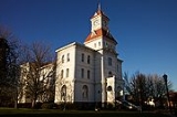
The city of Marysville, later renamed Corvallis, was made the county seat in 1851. In 1862 Corvallis became the site of the Oregon State Agricultural College, known today as Oregon State University
Oregon State University
Oregon State University is a coeducational, public research university located in Corvallis, Oregon, United States. The university offers undergraduate, graduate and doctoral degrees and a multitude of research opportunities. There are more than 200 academic degree programs offered through the...
.
Politics
The current Benton County Sheriff is Diana Simpson. She was elected on November 7, 2006 as the first woman sheriff of Benton County and the first elected female sheriff in Oregon.Incorporated cities
- Adair VillageAdair Village, OregonAdair Village is a city in Benton County, Oregon, United States. The population was 840 at the 2010 census, It is part of the "Corvallis, Oregon Metropolitan Statistical Area".-History:...
- AlbanyAlbany, OregonAlbany is the eleventh largest city in the U.S. state of Oregon, and is the county seat of Linn County. It is located in the Willamette Valley at the confluence of the Calapooia River and the Willamette River in both Linn and Benton counties, just east of Corvallis and south of Salem. It is...
, (small portion, most in Linn County) - CorvallisCorvallis, OregonCorvallis is a city located in central western Oregon, United States. It is the county seat of Benton County and the principal city of the Corvallis, Oregon Metropolitan Statistical Area, which encompasses all of Benton County. As of the 2010 United States Census, the population was 54,462....
- MonroeMonroe, OregonMonroe is a city in Benton County, Oregon, United States. The population was 607 at the 2000 census. It is part of the "Corvallis, Oregon Metropolitan Statistical Area"...
- PhilomathPhilomath, OregonPhilomath is a city in Benton County, Oregon, United States. It was named for Philomath College. The population was 3,838 at the 2000 census. It is part of the Corvallis, Oregon Metropolitan Statistical Area.- History :...
Unincorporated communities
- AlderAlder, OregonAlder is an unincorporated community in Benton County, Oregon, United States. Alder lies near U.S. Route 20 southeast of Blodgett on the Marys River in the Central Oregon Coast Range...
- AlpineAlpine, OregonAlpine is an unincorporated rural community in Benton County, Oregon, United States. It is west of Monroe off Oregon Route 99W. As of the 2010 Census, the population was 171.- History :...
- AlseaAlsea, OregonAlsea is an unincorporated community in Benton County, Oregon, United States. It is located on Oregon Route 34 and the Alsea River.As of the 2010 Census, the population was 164....
- BellfountainBellfountain, OregonBellfountain is an unincorporated community in Benton County, Oregon, United States. Bellfountain lies on Bellfountain Road north of Alpine and northwest of Monroe. The population was 75 at the 2010 census.-Early history:...
- BlodgettBlodgett, OregonBlodgett is an unincorporated community in Benton County, Oregon, United States, where Oregon Route 180 meets U.S. Route 20 in the Central Oregon Coast Range 15 miles west of Corvallis. It is near the confluence of the Tumtum and Marys rivers. The population was 58 at the 2010 census.Blodgett was...
- DawsonDawson, OregonDawson is an unincorporated community in Benton County, Oregon, United States. Dawson lies on Dawson Road west of Bellfountain, northwest of Alpine, and north of Glenbrook....
- Dry Creek
- FlynnFlynn, OregonFlynn is an unincorporated community in Benton County, Oregon, United States. Flynn is located on U.S. Route 20 at its interchange with Oregon Route 34, just west of Philomath, near the Marys River.-References:...
- GlenbrookGlenbrook, OregonGlenbrook is an unincorporated community in Benton County, Oregon, United States. Glenbrook lies on Alpine Road west of Alpine and south of Dawson....
- GreenberryGreenberry, OregonGreenberry is an unincorporated locale in Benton County, Oregon, United States. It is located on Oregon Route 99W about 8 miles south of Corvallis....
- HarrisHarris, OregonHarris is an unincorporated community in Benton County, Oregon, United States. Harris lies on U.S. Route 20 just south of its interchange with Oregon Route 223 in Wren....
- HoskinsHoskins, OregonHoskins is an unincorporated community in Benton County, Oregon, United States. Hoskins lies west of Oregon Route 223's intersection with Hoskins Road. Hoskins is northwest of Wren and southwest of Kings Valley....
- Kings ValleyKings Valley, OregonKings Valley is an unincorporated community in Benton County, Oregon, United States. It is located on the Luckiamute River and Oregon Route 223....
- LewisburgLewisburg, OregonLewisburg is an unincorporated community in Benton County, Oregon, United States. Lewisburg lies at the intersection of Oregon Route 99W and Lewisburg Avenue. Lewisburg is north of Corvallis and west of Albany....
- NoonNoon, OregonNoon is an unincorporated community in Benton County, Oregon, United States. Noon lies at the intersection of U.S. Route 20 and Noon Road. Noon is west of Flynn and Philomath....
- SummitSummit, OregonSummit is an unincorporated community in Benton County, Oregon, United States. Summit lies on Oregon Route 180 northwest of Blodgett....
- WrenWren, OregonWren is an unincorporated community in Benton County, Oregon, United States. It is located at the junction of U.S. Route 20 and Oregon Route 223 on the Marys River....