
Willamette Valley Flood of 1996
Encyclopedia
The Willamette Valley Flood of 1996 was part of a larger series of flood
s in the Pacific Northwest
of the United States
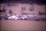
which took place between late January and mid-February, 1996. It was Oregon
's largest flood event in terms of fatalities and monetary damage during the 1990s. The floods spread well beyond Oregon's Willamette Valley
, extending west to the Oregon Coast
and east toward the Cascade Mountains. Significant flood damage also affected the American states of Washington, Idaho
(particularly the north of the state) and California
. The floods were directly responsible for eight deaths in Oregon, as well as over US$500 million in property damage throughout the Pacific Northwest. Three thousand residents were displaced from their homes.
An unusual confluence of weather events made the floods particularly severe. The winter
season preceding the floods had produced abnormally high rainfall and relatively low snowfall. The heavy rains saturated the ground and raised river levels throughout January 1996. In late January, a heavy snowstorm padded snow
packs throughout the region. This was followed by a deep freeze that lasted for six to ten days. The new layer of snow was quickly melted by a warm subtropical jetstream
which arrived on February 6. The jetstream brought along further rains. The combination of the additional rain, the saturated ground, and the melting snowpacks engorged dozens of streams and tributaries, which in turn flooded into the region's major rivers.
The Willamette River
, which flows through downtown Portland
, crested at 28.6 feet (8.7 m), some 10.6 feet (3.2 m) above flood stage. The river came within inches of overtopping its seawall
and flooding into Portland's downtown Tom McCall Waterfront Park
. A major sandbagging effort involving civilians as well as the Oregon National Guard was launched throughout downtown Portland, and was maintained until the floodwaters began to recede on February 9. At least five rivers in Oregon crested at all-time highs during the floods. The downtown areas of Oregon City
and Tillamook
suffered particularly heavy damage from the floods, and both were submerged for several days.
Flood
A flood is an overflow of an expanse of water that submerges land. The EU Floods directive defines a flood as a temporary covering by water of land not normally covered by water...
s in the Pacific Northwest
Pacific Northwest
The Pacific Northwest is a region in northwestern North America, bounded by the Pacific Ocean to the west and, loosely, by the Rocky Mountains on the east. Definitions of the region vary and there is no commonly agreed upon boundary, even among Pacific Northwesterners. A common concept of the...
of the United States
United States
The United States of America is a federal constitutional republic comprising fifty states and a federal district...
which took place between late January and mid-February, 1996. It was Oregon
Oregon
Oregon is a state in the Pacific Northwest region of the United States. It is located on the Pacific coast, with Washington to the north, California to the south, Nevada on the southeast and Idaho to the east. The Columbia and Snake rivers delineate much of Oregon's northern and eastern...
's largest flood event in terms of fatalities and monetary damage during the 1990s. The floods spread well beyond Oregon's Willamette Valley
Willamette Valley
The Willamette Valley is the most populated region in the state of Oregon of the United States. Located in the state's northwest, the region is surrounded by tall mountain ranges to the east, west and south and the valley's floor is broad, flat and fertile because of Ice Age conditions...
, extending west to the Oregon Coast
Oregon Coast
The Oregon Coast is a region of the U.S. state of Oregon. It runs generally north-south along the Pacific Ocean, forming the western border of the state; the region is bounded to the east by the Oregon Coast Range. The Oregon Coast stretches approximately from the Columbia River in the north to...
and east toward the Cascade Mountains. Significant flood damage also affected the American states of Washington, Idaho
Idaho
Idaho is a state in the Rocky Mountain area of the United States. The state's largest city and capital is Boise. Residents are called "Idahoans". Idaho was admitted to the Union on July 3, 1890, as the 43rd state....
(particularly the north of the state) and California
California
California is a state located on the West Coast of the United States. It is by far the most populous U.S. state, and the third-largest by land area...
. The floods were directly responsible for eight deaths in Oregon, as well as over US$500 million in property damage throughout the Pacific Northwest. Three thousand residents were displaced from their homes.
An unusual confluence of weather events made the floods particularly severe. The winter
Winter
Winter is the coldest season of the year in temperate climates, between autumn and spring. At the winter solstice, the days are shortest and the nights are longest, with days lengthening as the season progresses after the solstice.-Meteorology:...
season preceding the floods had produced abnormally high rainfall and relatively low snowfall. The heavy rains saturated the ground and raised river levels throughout January 1996. In late January, a heavy snowstorm padded snow
Snow
Snow is a form of precipitation within the Earth's atmosphere in the form of crystalline water ice, consisting of a multitude of snowflakes that fall from clouds. Since snow is composed of small ice particles, it is a granular material. It has an open and therefore soft structure, unless packed by...
packs throughout the region. This was followed by a deep freeze that lasted for six to ten days. The new layer of snow was quickly melted by a warm subtropical jetstream
JetStream
JetStream and Mobile JetStream are two former brand names used by Telecom New Zealand to market its retail and resale ADSL-based fixed line and CDMA2000-based 3G wireless Internet access offerings respectively...
which arrived on February 6. The jetstream brought along further rains. The combination of the additional rain, the saturated ground, and the melting snowpacks engorged dozens of streams and tributaries, which in turn flooded into the region's major rivers.
The Willamette River
Willamette River
The Willamette River is a major tributary of the Columbia River, accounting for 12 to 15 percent of the Columbia's flow. The Willamette's main stem is long, lying entirely in northwestern Oregon in the United States...
, which flows through downtown Portland
Portland, Oregon
Portland is a city located in the Pacific Northwest, near the confluence of the Willamette and Columbia rivers in the U.S. state of Oregon. As of the 2010 Census, it had a population of 583,776, making it the 29th most populous city in the United States...
, crested at 28.6 feet (8.7 m), some 10.6 feet (3.2 m) above flood stage. The river came within inches of overtopping its seawall
Seawall
A seawall is a form of coastal defence constructed where the sea, and associated coastal processes, impact directly upon the landforms of the coast. The purpose of a seawall is to protect areas of human habitation, conservation and leisure activities from the action of tides and waves...
and flooding into Portland's downtown Tom McCall Waterfront Park
Tom McCall Waterfront Park
Governor Tom McCall Waterfront Park is a park located on the west bank of the Willamette River in downtown Portland, Oregon. It is , comprising 16 tax lots owned by the City of Portland....
. A major sandbagging effort involving civilians as well as the Oregon National Guard was launched throughout downtown Portland, and was maintained until the floodwaters began to recede on February 9. At least five rivers in Oregon crested at all-time highs during the floods. The downtown areas of Oregon City
Oregon City, Oregon
Oregon City was the first city in the United States west of the Rocky Mountains to be incorporated. It is the county seat of Clackamas County, Oregon...
and Tillamook
Tillamook, Oregon
The city of Tillamook is the county seat of Tillamook County, Oregon, United States. The city is located on the southeast end of Tillamook Bay on the Pacific Ocean. The population was 4,352 at the 2000 census...
suffered particularly heavy damage from the floods, and both were submerged for several days.