
Trunk Roads in Ireland
Encyclopedia
Ireland
has an extensive network of public roads which connect all parts of the country with each other. Roads in Ireland
are currently classified as motorways
, National Primary routes
, National secondary routes
, Regional road
s and Local roads
. The introduction of this classification system began in 1977.
Prior to this, Ireland
had a different road classification and numbering system. Roads fell into three categories: T (Trunk Roads), L (Link Roads) and unclassified roads. The origins of this system lie in pre-independence legislation: the preliminary section of Statutory Instrument S.I. No. 55/1926 — Road Signs and Traffic Signals Regulations, 1926 states that the Ministry of Transport Act, 1919 gave the Minister for Local Government and Public Health the power to assign a "route letter and number" to a road, while Section 6.4 of Part I of the Regulations specifies the positioning of the "route letter and the number of the road" on directional signs. A reference in the Statutory Instrument to the "classification of roads as a 'Trunk' or 'Link' Road" indicates that a system of route classification and numbering was envisaged in the 1920s. However, at present, there is no information about when the Trunk and Link road-numbering system was actually introduced on signposts. Even though legal authority for the erection of directional signposts was given to local councils, the Automobile Association of Ireland
began an extensive road signposting scheme in 1938 which included comprehensive signposting of routes from Belfast, Cork and Dublin.
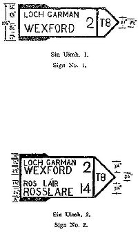
Evidence that the Trunk Road and Link Road classification and numbering system had been well established by the 1950s is found in Statutory Instrument S.I. No. 284/1956 — Traffic Signs Regulations, 1956 which contains examples of several directional signs. The first and second examples show the T8 as the route to Wexford and Rosslare. In addition, Esso
road-maps of Ireland from the 1950s show the Trunk and Link road network. Despite its long-standing use, the original Trunk and Link road system was never legislated for and the routes of Trunk Roads and Link Roads were never formally designated by law.
This current system of road classification and numbering has its origins in the late 1960s: the Minister for Local Government, Kevin Boland
, announced on 23 July 1969 that a national road network would be formed. In 1974, the Local Government (Roads and Motorways) Act came into effect. It allowed for designation of roads as motorways or national roads. National roads were first designated by Statutory Instrument S.I. No. 164/1977 on 1 June 1977. Twenty-five National Primary routes (N1-N25) and thirty-three National Secondary routes (N51-N83) were initially designated.
The changeover to the new system was gradual: a route planning map of Ireland from the late 1970s (or early 1980s), divided into a northern section and a southern section, shows a mixture of Trunk Road, Link Road and National route numbers.

 Major roads were marked with "T" for Trunk Road
, less important roads were marked with "L" for Link Road.
Trunk Roads connected major towns to each other while passing through smaller towns and villages.
Several trunk routes were designed to connect towns in different regions of Ireland (for example, the T41 from Enfield
to Kilrush
, via Tullamore
, Portumna
, Scariff and Ennis
) while other roads (for example, the T66 Ring of Kerry
route) were designated scenic route
s.
Link Roads connected smaller towns and villages to each other and to the Trunk Road network.
There were eighty-four Trunk Roads in total, numbered from T1 to T77 consecutively (plus T4a, T11a, T12a, T21a, T28a, T50a and T72a). Roads with the 'a' suffix branched off roads with the same number. For example, the T4a branched off the T4 at Ballinasloe in Co. Galway and the T12a branched off the T12 to serve Cobh
in Co. Cork.
The first nine Trunk Roads (T1, T2, T3, T4, T4a, T5, T6, T7, T8) radiated out from Dublin (with the T8 branching off the T7 at Enniscorthy
) and followed an anti-clockwise pattern. This pattern was similar to the existing anti-clockwise pattern which the National routes and motorways radiating out of Dublin now follow. The pattern was interrupted by the T35 (Dublin-Cavan
-Donegal
route) which came between the T2 and the T3 and the T42 (now N81), T43 and T44 which came between the T5 (T6) and the T7 routes.
Unlike the present system, where each road (whether N- or R-) has a unique number, under the Trunk and Link Road system, Link Roads were numbered separately beginning with L1. These L (for Link Road) numbers are not related to the current Lxxxx numbers for Local Roads.
Confusingly, some old road signs
still show the former (now obsolete) Trunk and Link road-numbers.
Trunk Roads were broadly equivalent to the present National routes, and Link Roads to the present Regional roads. Most of the National Primary and National Secondary routes had been Trunk Roads and generally they followed the routes of these Trunk Roads, albeit with a different numbering system. However, some National Primary and Secondary routes also incorporated Link Roads and unclassified roads into their routes. After the introduction of the new road numbering system, some Trunk Roads (either in whole or in part) were downgraded to Regional roads, effectively 'de-trunked'Trunk road#De-trunking: Ireland.
A notable feature of the former system was multiplexing
(or concurrency), where a section of road was designated by two or more route numbers. Examples of multiplexes include the T7/T12 multiplex between New Ross
and Waterford
, the T6/T13 multiplex between Cahir
and Kilheffernan (east of Clonmel
), the T28/T36 multiplex between Newcastlewest and Abbeyfeale
and the short T19/T21 multiplex between Thurles
and Toor. The road between Cavan
, Butlersbridge
, Cloverhill and the border with Northern Ireland (near Wattle Bridge in Co. Fermanagh) was a triple multiplex of the T10, T15 and T35 routes.
Three routes (T15, T22, T35) had sections which were disconnected from the rest of the route by roads which crossed through Northern Ireland
. These routes lost their Trunk Road designations through Northern Ireland, regaining them on exiting Northern Ireland. The T15 crossed the border
several times between Cavan and Clones
, alternating between the T15 and the A3
designations.
Multiplex sections (for example, New Ross-Waterford (multiplex with T12)) are shown in italics. Sections of routes through Northern Ireland (with different designations) are shown in bold (for example, border-A37-Cullaville-A37-border or border-(to Belfast via A1)).
Ireland
Ireland is an island to the northwest of continental Europe. It is the third-largest island in Europe and the twentieth-largest island on Earth...
has an extensive network of public roads which connect all parts of the country with each other. Roads in Ireland
Roads in Ireland
The island of Ireland, comprising Northern Ireland and the Republic of Ireland, has an extensive network of tens of thousands of kilometres of public roads, usually surfaced. These roads have been developed and modernised over centuries, from trackways suitable only for walkers and horses, to...
are currently classified as motorways
Motorways in the Republic of Ireland
In Ireland, the highest category of road is a Motorway , indicated by the prefix M followed by one or two digits...
, National Primary routes
National primary road
A national primary road is a road classification in the Republic of Ireland. National primary roads form the major routes between the major urban centres. There are over 2,700km of national primary roads. This category of road has the prefix "N" followed by one or two digits...
, National secondary routes
National secondary road
A national secondary road is a category of road in Ireland. These roads form an important part of the national route network, but are secondary to the main arterial routes which are classified as national primary roads. National secondary roads are designated with route numbers higher than those...
, Regional road
Regional road
A regional road in Ireland is a class of road not forming a major route , but nevertheless forming a link in the national route network. There are over 11,600 kilometres of regional roads. Regional roads are numbered with three digit route numbers, prefixed by "R" A regional road in Ireland is a...
s and Local roads
Local Roads in Ireland
A Local Road in Ireland is a class of public road not classified as a National road or as a Regional road but nevertheless forming a link in the national network of roads...
. The introduction of this classification system began in 1977.
Prior to this, Ireland
Ireland
Ireland is an island to the northwest of continental Europe. It is the third-largest island in Europe and the twentieth-largest island on Earth...
had a different road classification and numbering system. Roads fell into three categories: T (Trunk Roads), L (Link Roads) and unclassified roads. The origins of this system lie in pre-independence legislation: the preliminary section of Statutory Instrument S.I. No. 55/1926 — Road Signs and Traffic Signals Regulations, 1926 states that the Ministry of Transport Act, 1919 gave the Minister for Local Government and Public Health the power to assign a "route letter and number" to a road, while Section 6.4 of Part I of the Regulations specifies the positioning of the "route letter and the number of the road" on directional signs. A reference in the Statutory Instrument to the "classification of roads as a 'Trunk' or 'Link' Road" indicates that a system of route classification and numbering was envisaged in the 1920s. However, at present, there is no information about when the Trunk and Link road-numbering system was actually introduced on signposts. Even though legal authority for the erection of directional signposts was given to local councils, the Automobile Association of Ireland
The Automobile Association (Ireland)
The Automobile Association has been operating in Ireland since 1910. Today, AA Ireland is Ireland’s leading motoring organisation and provider of rescue services. It is also one of Ireland’s leading personal lines insurance intermediary and a major provider of travel, technical and information...
began an extensive road signposting scheme in 1938 which included comprehensive signposting of routes from Belfast, Cork and Dublin.
Evidence that the Trunk Road and Link Road classification and numbering system had been well established by the 1950s is found in Statutory Instrument S.I. No. 284/1956 — Traffic Signs Regulations, 1956 which contains examples of several directional signs. The first and second examples show the T8 as the route to Wexford and Rosslare. In addition, Esso
Esso
Esso is an international trade name for ExxonMobil and its related companies. Pronounced , it is derived from the initials of the pre-1911 Standard Oil, and as such became the focus of much litigation and regulatory restriction in the United States. In 1972, it was largely replaced in the U.S. by...
road-maps of Ireland from the 1950s show the Trunk and Link road network. Despite its long-standing use, the original Trunk and Link road system was never legislated for and the routes of Trunk Roads and Link Roads were never formally designated by law.
This current system of road classification and numbering has its origins in the late 1960s: the Minister for Local Government, Kevin Boland
Kevin Boland
Kevin Boland , was a senior Irish politician. He was first elected to Dáil Éireann in 1957 as a Fianna Fáil TD. He served as Minister for Defence , Minister for Social Welfare and Minister for Local Government...
, announced on 23 July 1969 that a national road network would be formed. In 1974, the Local Government (Roads and Motorways) Act came into effect. It allowed for designation of roads as motorways or national roads. National roads were first designated by Statutory Instrument S.I. No. 164/1977 on 1 June 1977. Twenty-five National Primary routes (N1-N25) and thirty-three National Secondary routes (N51-N83) were initially designated.
The changeover to the new system was gradual: a route planning map of Ireland from the late 1970s (or early 1980s), divided into a northern section and a southern section, shows a mixture of Trunk Road, Link Road and National route numbers.
Trunk Roads and Link Roads
Trunk road
A trunk road, trunk highway, or strategic road is a major road—usually connecting two or more cities, ports, airports, and other things.—which is the recommended route for long-distance and freight traffic...
, less important roads were marked with "L" for Link Road.
Trunk Roads connected major towns to each other while passing through smaller towns and villages.
Several trunk routes were designed to connect towns in different regions of Ireland (for example, the T41 from Enfield
Enfield, County Meath
Enfield or Innfield is a town in south County Meath, Ireland, situated between Kilcock and Kinnegad and very close to the border with County Kildare...
to Kilrush
Kilrush
Kilrush is a coastal town in County Clare, Ireland. It is located near the mouth of the River Shannon in the south-west of the county. Kilrush is a town of great historical significance, being one of the listed Heritage Towns of Ireland.-History:...
, via Tullamore
Tullamore
Tullamore is a town in County Offaly, in the midlands of Ireland. It is Offaly's county town and the centre of the district.Tullamore is an important commercial and industrial centre in the region. Major international employers in the town include 'Tyco Healthcare' and 'Boston Scientific'. In...
, Portumna
Portumna
Portumna is a market town in the south-east of County Galway, Ireland, on the border with County Tipperary. The town is located to the west of the point where the River Shannon enters Lough Derg. This historic crossing point over the River Shannon between counties Tipperary and Galway has a long...
, Scariff and Ennis
Ennis
Ennis is the county town of Clare in Ireland. Situated on the River Fergus, it lies north of Limerick and south of Galway. Its name is a shortening of the original ....
) while other roads (for example, the T66 Ring of Kerry
Ring of Kerry
The Ring of Kerry is a tourist trail in County Kerry, south-western Ireland. The route covers the 179 km circular road , starting from Killarney, heading around the Iveragh Peninsula and passing through Kenmare, Sneem, Waterville, Cahersiveen and Killorglin...
route) were designated scenic route
Scenic route
A scenic route, tourist road, tourist route, theme route, or scenic byway is a specially designated road or waterway that travels through an area of natural or cultural beauty...
s.
Link Roads connected smaller towns and villages to each other and to the Trunk Road network.
There were eighty-four Trunk Roads in total, numbered from T1 to T77 consecutively (plus T4a, T11a, T12a, T21a, T28a, T50a and T72a). Roads with the 'a' suffix branched off roads with the same number. For example, the T4a branched off the T4 at Ballinasloe in Co. Galway and the T12a branched off the T12 to serve Cobh
Cobh
Cobh is a seaport town on the south coast of County Cork, Ireland. Cobh is on the south side of Great Island in Cork Harbour. Facing the town are Spike Island and Haulbowline Island...
in Co. Cork.
The first nine Trunk Roads (T1, T2, T3, T4, T4a, T5, T6, T7, T8) radiated out from Dublin (with the T8 branching off the T7 at Enniscorthy
Enniscorthy
Enniscorthy is the second largest town in County Wexford, Ireland. The population of the town and environs is 9538. The Placenames Database of Ireland sheds no light on the origins of the town's name. It may refer either to the "Island of Corthaidh" or the "Island of Rocks". With a history going...
) and followed an anti-clockwise pattern. This pattern was similar to the existing anti-clockwise pattern which the National routes and motorways radiating out of Dublin now follow. The pattern was interrupted by the T35 (Dublin-Cavan
Cavan
Cavan is the county town of County Cavan in the Republic of Ireland. The town lies in the north central part of Ireland, near the border with Northern Ireland...
-Donegal
Donegal
Donegal or Donegal Town is a town in County Donegal, Ireland. Its name, which was historically written in English as Dunnagall or Dunagall, translates from Irish as "stronghold of the foreigners" ....
route) which came between the T2 and the T3 and the T42 (now N81), T43 and T44 which came between the T5 (T6) and the T7 routes.
Unlike the present system, where each road (whether N- or R-) has a unique number, under the Trunk and Link Road system, Link Roads were numbered separately beginning with L1. These L (for Link Road) numbers are not related to the current Lxxxx numbers for Local Roads.
Confusingly, some old road signs
Road signs in the Republic of Ireland
Road signs in Ireland mostly differ from the traffic signs used elsewhere in Europe. Directional signage is similar to that of the United Kingdom, but is bilingual. Distances are in kilometres. Apart from directional signage, the basic prohibitory signs such as "no left turn" and "no right turn"...
still show the former (now obsolete) Trunk and Link road-numbers.
Trunk Roads were broadly equivalent to the present National routes, and Link Roads to the present Regional roads. Most of the National Primary and National Secondary routes had been Trunk Roads and generally they followed the routes of these Trunk Roads, albeit with a different numbering system. However, some National Primary and Secondary routes also incorporated Link Roads and unclassified roads into their routes. After the introduction of the new road numbering system, some Trunk Roads (either in whole or in part) were downgraded to Regional roads, effectively 'de-trunked'Trunk road#De-trunking: Ireland.
A notable feature of the former system was multiplexing
Concurrency (road)
A concurrency, overlap, or coincidence in a road network is an instance of one physical road bearing two or more different highway, motorway, or other route numbers...
(or concurrency), where a section of road was designated by two or more route numbers. Examples of multiplexes include the T7/T12 multiplex between New Ross
New Ross
New Ross is a town located in southwest County Wexford, in the southeast of Ireland. In 2006 it had a population of 7,709 people, making it the third largest town in the county after Wexford and Enniscorthy.-History:...
and Waterford
Waterford
Waterford is a city in the South-East Region of Ireland. It is the oldest city in the country and fifth largest by population. Waterford City Council is the local government authority for the city and its immediate hinterland...
, the T6/T13 multiplex between Cahir
Cahir
Cahir is a town in South Tipperary in Ireland. The town is best known for its castle and the Swiss Cottage. It is in the barony of Iffa and Offa West.-Location and access:...
and Kilheffernan (east of Clonmel
Clonmel
Clonmel is the county town of South Tipperary in Ireland. It is the largest town in the county. While the borough had a population of 15,482 in 2006, another 17,008 people were in the rural hinterland. The town is noted in Irish history for its resistance to the Cromwellian army which sacked both...
), the T28/T36 multiplex between Newcastlewest and Abbeyfeale
Abbeyfeale
Abbeyfeale is a historical market town in County Limerick, Ireland near the boundary with County Kerry. The town is in the midwest of Ireland, some from Newcastle West on the N21 – the main road from Limerick to Tralee.-Geography:...
and the short T19/T21 multiplex between Thurles
Thurles
Thurles is a town situated in North Tipperary, Ireland. It is a civil parish in the historical barony of Eliogarty and is also an ecclesiastical parish in the Roman Catholic Archdiocese of Cashel and Emly...
and Toor. The road between Cavan
Cavan
Cavan is the county town of County Cavan in the Republic of Ireland. The town lies in the north central part of Ireland, near the border with Northern Ireland...
, Butlersbridge
Butlersbridge
Butlersbridge is a village in County Cavan in Ireland, north of Cavan Town just off the N3 National primary road. It was well known as point on the N3 but it was bypassed in 1999. The bridge in the village crosses the River Annalee, a tributary of the River Erne.-Transport:The former GNR line...
, Cloverhill and the border with Northern Ireland (near Wattle Bridge in Co. Fermanagh) was a triple multiplex of the T10, T15 and T35 routes.
Three routes (T15, T22, T35) had sections which were disconnected from the rest of the route by roads which crossed through Northern Ireland
Northern Ireland
Northern Ireland is one of the four countries of the United Kingdom. Situated in the north-east of the island of Ireland, it shares a border with the Republic of Ireland to the south and west...
. These routes lost their Trunk Road designations through Northern Ireland, regaining them on exiting Northern Ireland. The T15 crossed the border
Republic of Ireland-United Kingdom border
The Republic of Ireland–United Kingdom border is the boundary between the sovereign states of the Republic of Ireland and the United Kingdom of Great Britain and Northern Ireland...
several times between Cavan and Clones
Clones
Clones is a small town in western County Monaghan, in the 'border area' of the Republic of Ireland. The area is part of the Border Region, earmarked for economic development by the Irish Government due to its currently below-average economic situation...
, alternating between the T15 and the A3
A3 road (Northern Ireland)
The A3 is a major road in Northern Ireland. It travels through County Antrim, County Down, County Armagh and parts of southern County Fermanagh....
designations.
List of Former Trunk Roads in Ireland
Route descriptions show start and end points and selected intermediate destinations and junctions. The current designations of routes (or route sections) is then given.Multiplex sections (for example, New Ross-Waterford (multiplex with T12)) are shown in italics. Sections of routes through Northern Ireland (with different designations) are shown in bold (for example, border-A37-Cullaville-A37-border or border-(to Belfast via A1)).
| Road | From | To | Route Description |
|---|---|---|---|
| T1 | Dublin | (Belfast Belfast Belfast is the capital of and largest city in Northern Ireland. By population, it is the 14th biggest city in the United Kingdom and second biggest on the island of Ireland . It is the seat of the devolved government and legislative Northern Ireland Assembly... ) |
Dublin-Swords Swords, Dublin Swords is the county town of Fingal in Ireland. It is about 13 km north of Dublin city centre and is part of its commuter belt.- History :... -Balbriggan Balbriggan Balbriggan is a town in the northern part of the administrative county of Fingal, within County Dublin, Ireland. The 2006 census population was 15,559 for Balbriggan and its environs.- Name :... -Drogheda Drogheda Drogheda is an industrial and port town in County Louth on the east coast of Ireland, 56 km north of Dublin. It is the last bridging point on the River Boyne before it enters the Irish Sea.... -Dunleer Dunleer Dunleer is a town and townland in County Louth, Ireland.Dunleer town is situated midway between Dundalk and Drogheda. It is the principal Town Borough in the Barony of Ferrard. It has a Charter dating back to 1252... -Dundalk Dundalk Dundalk is the county town of County Louth in Ireland. It is situated where the Castletown River flows into Dundalk Bay. The town is close to the border with Northern Ireland and equi-distant from Dublin and Belfast. The town's name, which was historically written as Dundalgan, has associations... -border-(to Belfast Belfast Belfast is the capital of and largest city in Northern Ireland. By population, it is the 14th biggest city in the United Kingdom and second biggest on the island of Ireland . It is the seat of the devolved government and legislative Northern Ireland Assembly... via A1 A1 road (Northern Ireland) The A1 is a major route in Northern Ireland. It runs from Belfast via Lisburn and Banbridge to the border with the Republic of Ireland south of Newry, from where the road continues to Dublin, becoming the N1 road and M1 motorway... ). Now mainly R132 R132 road The R132 road is one of Ireland's newest regional roads, having been classified following the opening M1 motorway which by-passes most of the old N1 route.By-passed sections of the old N1 were reclassified R132... (re-classified, old N1 prior to opening of M1 (Republic of Ireland) and various bypasses). |
| T2 | Dublin | (Derry Derry Derry or Londonderry is the second-biggest city in Northern Ireland and the fourth-biggest city on the island of Ireland. The name Derry is an anglicisation of the Irish name Doire or Doire Cholmcille meaning "oak-wood of Colmcille"... ) |
Dublin-Ashbourne Ashbourne, County Meath Ashbourne, historically called Killeglan or Kildeglan , is a town in County Meath, Ireland. It is about 20 km north of Dublin city centre and is bypassed by the M2 motorway.-History:... -Slane Slane Slane is a village in County Meath, in Ireland. The village stands on a steep hillside on the left bank of the River Boyne at the intersection of the N2 and the N51 . In 2006 Slane's population was 1,099, having grown from 823 in 2002. The population of the village and the surrounding rural area... -Collon Collon Collon is a village and townland in the south west corner of County Louth, Ireland on the N2 national primary road. The village is home to the Cistercian Abbey of New Mellifont.-Facilities:... -Ardee Ardee Ardee is a town and townland in County Louth, Ireland. It is located at the intersection of the N2, N52, and N33 roads. Ardee is on the banks of the River Dee and is approximately 20 km from Dundalk, Drogheda, Slane and Carrickmacross... -Carrickmacross Carrickmacross Carrickmacross or Carrickmacros is a town in County Monaghan, Ireland. The town and environs had a population of 4,387 according to the 2006 census, making it the second largest town in the county. The town won the prestigious European Entente Florale Silver Medal Award. It is a market town which... -Castleblayney Castleblayney Castleblayney or Castleblaney is a town in County Monaghan, Ireland. The town has a population of about 3,000.Castleblayney lies near the border with County Armagh and is on the N2 road from Dublin to Derry... -Monaghan Monaghan Monaghan is the county town of County Monaghan in Ireland. Its population at the 2006 census stood at 7,811 . The town is located on the main road, the N2 road, from Dublin north to both Derry and Letterkenny.-Toponym:... -Emyvale Emyvale Emyvale, known before the Plantation of Ulster as Scarnageeragh or Scarna , is a village and townland in the north of County Monaghan, Ireland. It sits upon the main Dublin to Derry and Letterkenny road, the , about 10 km north of Monaghan and 8 km south of Aughnacloy... -border-(to Derry via A5 A5 road (Northern Ireland) The A5 is a major primary route in Northern Ireland. It travels through County Londonderry and County Tyrone, commencing in the city of Derry, passing the large towns of Strabane and Omagh before it meets the N2 across the border in the Republic of Ireland towards the final destination of... ). Now R135 R135 road The R135 road is one of Ireland's newest regional roads, being a reclassification of those sections of the former N2 which were bypassed when the N2 Ashbourne By-Pass dual carriageway opened in 2006, and when the Carrickmacross, Castleblayney & Monaghan bypasses were completed.-References:* – ... (sections of former N2 bypassed by HQDC High-quality dual carriageway A High-quality dual carriageway is a category of road in the Republic of Ireland. It is an all-purpose dual carriageway road type built to near motorway standards, but without motorway classification or motorway restrictions. High-quality dual carriageways have full grade-separated access and do... between M50 M50 motorway (Ireland) The M50 motorway is a motorway in Ireland running in a C-shaped ring around the north-eastern, northern, western and southern sides of the capital city, Dublin. The northern end of the route is located at the entrance to the Dublin Port Tunnel. Anti-clockwise it heads northwest through the tunnel... and Ashbourne and various bypasses) and N2 (Ashbourne-border). |
| T3 | Dublin | Sligo Sligo Sligo is the county town of County Sligo in Ireland. The town is a borough and has a charter and a town mayor. It is sometimes referred to as a city, and sometimes as a town, and is the second largest urban area in Connacht... |
Dublin-Lucan-Leixlip Leixlip -Politics:Since 1988 Leixlip has had a nine member Town Council , headed by a Cathaoirleach , which has control over many local matters, although it is limited in that it is not also a planning authority... -Maynooth Maynooth Maynooth is a town in north County Kildare, Ireland. It is home to a branch of the National University of Ireland, a Papal University and Ireland's main Roman Catholic seminary, St. Patrick's College... -Enfield Enfield, County Meath Enfield or Innfield is a town in south County Meath, Ireland, situated between Kilcock and Kinnegad and very close to the border with County Kildare... -Kinnegad Kinnegad Kinnegad or Kinagad is a town in County Westmeath, Ireland. It is near the border with County Meath, at the junction of the N6 and the N4 - two of Ireland's main east-west roads... -Mullingar Mullingar Mullingar is the county town of County Westmeath in Ireland. The Counties of Meath and Westmeath Act of 1542, proclaimed Westmeath a county, separating it from Meath. Mullingar became the administrative centre for County Westmeath... -Edgeworthstown Edgeworthstown Edgeworthstown or Mostrim is a town in County Longford, Ireland. The Edgeworthstown name is derived from the Edgeworth Family who have a long association with the town as the family estate of Henry Essex Edgeworth de Firmont was nearby, while Mostrim is an anglicisation of the town's pre-conquest... -Longford Longford Longford is the county town of County Longford in Ireland. It has a population of 7,622 according to the 2006 census. Approximately one third of the county's population resides in the town. Longford town is also the biggest town in the county... -Roosky Roosky Roosky or Rooskey is a village on the River Shannon in County Roscommon, Ireland in the northern midlands of Ireland, near the point where counties Leitrim, Longford, and Roscommon meet. The N4 road from Dublin to Sligo passes by the Leitrim side of the village.- History :Roosky has had a... -Dromod Dromod Dromod is a village in County Leitrim, Ireland. Dromod is a noted fishing village on Loughs Bofin and Boderg, which are threaded by the River Shannon.... -Carrick-on-Shannon Carrick-on-Shannon Carrick-on-Shannon is the county town of County Leitrim in Ireland. It is also the smallest main county town in the country . It is situated on a strategic crossing point of the River Shannon and is the largest town in the county. The population of the town was 3,163 in 2006. It is in the barony... -Boyle Boyle, County Roscommon Boyle is a town in County Roscommon, Ireland. It is located at the foot of the Curlew Mountains near Lough Key in the north of the county. Carrowkeel Megalithic Cemetery, the Drumanone Dolmen and the popular fishing lakes of Lough Arrow and Lough Gara are also close by... -Collooney Collooney -Transport:Collooney is located just off the N4 and N17 roads, having been bypassed twice, by the N4 in 1998, and the N17 in 1992, and is the meeting point of both roads. The town was a significant railway centre, with no less than three railway stations... -Sligo. Now N4 (Dublin-Lucan), R148 R148 road The R148 road is one of Ireland's regional roads which was classified following the opening of a by-passed national primary road.The section of the old N4 which has been by-passed by the M4 motorway was reclassified R148. The R148 runs from Dublin to Kinnegad in County Westmeath.The road is long... (sections of former N4 bypassed by M4 and various bypasses) (Lucan-Kinnegad) and N4 (Kinnegad-Sligo). |
| T4 | (Dublin) | Galway Galway Galway or City of Galway is a city in County Galway, Republic of Ireland. It is the sixth largest and the fastest-growing city in Ireland. It is also the third largest city within the Republic and the only city in the Province of Connacht. Located on the west coast of Ireland, it sits on the... |
(Dublin)-Kinnegad-Rochfortbridge Rochfortbridge Rochfortbridge is a village in County Westmeath, Ireland, with a population of 1,473 persons. It is located at the intersection of the R400 and the N6 national primary route, which recently bypassed the village.... -Kilbeggan Kilbeggan -Geography:Kilbeggan is situated on the River Brosna, in the south of County Westmeath. It lies southeast of Lough Ennell, north of the boundary with County Offaly, about 9 kilometres north of Tullamore. Kilbeggan is surrounded by the gently rolling Esker Riada, the linear sand hills that stretch... -Moate Moate Moate is a town in County Westmeath, Ireland.The name An Móta is derived from the term motte-and-bailey as the Normans built an example of this type of fortification here. The earthwork is still visible behind the buildings on the main street.... -Athlone-Ballinasloe (multiplex with T31)-Kilconnell Kilconnell Kilconnell is a small rural village in County Galway, Ireland.Its population in 2006 was 680. Its land is mainly used for dairy farming and the raising of cattle.... -Kiltullagh-Athenry Athenry Athenry is a town in County Galway, Ireland. It lies east of Galway city, and one of the attractions of the town is its medieval castle. The town is also well-known by virtue of the song "The Fields of Athenry".-History:... -Derrydonnell-Oranmore Oranmore Oranmore is a village in County Galway on the outskirts of Galway city in Ireland. With its major housing developments, Oranmore is rapidly becoming a part of Galway's commuter or suburban belt... -Galway. Now R446 R446 road The R446 road is one of Ireland's newest regional roads, having been classified following the opening in 2006 of the N6 High Quality Dual Carriageway which by-passes the old route.... (sections of former N6 bypassed by M6 M6 motorway (Ireland) The M6 motorway is a motorway in Ireland, which runs from Dublin to Galway. The M6 extends from its junction with the M4 at Kinnegad all the way west to the outskirts of Galway City, but the Athlone bypass and the approach to Galway city - while of dual carriageway standard - have not been... and various bypasses) (Kinnegad-Athlone), N6 (Athlone-Ballinasloe), R348 (Ballinasloe-Derrydonnell) and old N6 (Derrydonnell-Oranmore-Galway). |
| T4a | Ballinasloe | Loughrea Loughrea Loughrea is a town in County Galway, Ireland. The town lies north of a range of wooded hills, the Slieve Aughty Mountains.The town expanded in recent years as it increasingly becomes a commuter town for the city of Galway.- Name :... |
(Dublin)-Ballinasloe-Garbally-Aughrim Aughrim, County Galway Aughrim is a small village in County Galway, Ireland. It is located in the west of Ireland, between the towns of Loughrea and Ballinasloe, along the N6 national primary road that connects Galway and Dublin.... -Kilreekill-Kilmeen-Loughrea Loughrea Loughrea is a town in County Galway, Ireland. The town lies north of a range of wooded hills, the Slieve Aughty Mountains.The town expanded in recent years as it increasingly becomes a commuter town for the city of Galway.- Name :... (multiplex with T21). Now N6 (Ballinasloe-Loughrea), as it was prior to the opening of the Loughrea bypass and other improvements. Multiplexed with T21 from Kilmeen to Loughrea. |
| T5 | Dublin | Limerick Limerick Limerick is the third largest city in the Republic of Ireland, and the principal city of County Limerick and Ireland's Mid-West Region. It is the fifth most populous city in all of Ireland. When taking the extra-municipal suburbs into account, Limerick is the third largest conurbation in the... |
Dublin-Naas Naas Naas is the county town of County Kildare in Ireland. With a population of just over twenty thousand, it is also the largest town in the county. Naas is a major commuter suburb, with many people residing there and working in Dublin... -Newbridge Newbridge, County Kildare The earliest known mention of Newbridge was by traveller and bookseller John Dunton in 1698, though he does not refer to any settlement other than at Ballymany.... -Kildare Kildare -External links:*******... -Monasterevin Monasterevin Situated 63 km from Dublin on the R445 road, Monasterevin has been relieved of much through traffic by the opening in 2004 of a new section of the M7 motorway bypassing the town on the N7 Dublin to Limerick route... -Portlaoise-Mountrath Mountrath Mountrath is a small town in County Laois, Ireland. Bypassed by the M7 motorway in 2010, the town lies on the R445 midway between Dublin and Limerick, exactly 96.5 km from both cities.In 2006 it had a population of 1,435... -Borris-in-Ossory Borris-in-Ossory Borris-in-Ossory is a village in west County Laois, Ireland. Bypassed by the M7 motorway on 28 May, 2010, the village is situated on the R445 road close to the County Tipperary border between the towns of Mountrath and Roscrea.-Features:... -Roscrea Roscrea Roscrea is a small heritage town in North Tipperary, Ireland. The town has a population of 4,910. Its main industries include meat processing and pharmaceuticals. It is a civil parish in the historical barony of Ikerrin... -Nenagh Nenagh Nenagh is the county town of North Tipperary in Ireland. It is the administrative centre of North Tipperary and in 2011 it had a recorded population of 7,995. It is a civil parish in the historical barony of Ormond Lower... -Lisnagry-Limerick Limerick Limerick is the third largest city in the Republic of Ireland, and the principal city of County Limerick and Ireland's Mid-West Region. It is the fifth most populous city in all of Ireland. When taking the extra-municipal suburbs into account, Limerick is the third largest conurbation in the... . Now N7 (Dublin-Naas), R445 R445 road The R445 road is a regional road in Ireland. The route is a non-motorway alternative route to the N7/M7 motorway between Dublin and Limerick. Indeed, much of the route comprises roads that were formerly part of the N7 between the cities, prior to motorway and other bypasses... (sections of former N7 bypassed by M7 and various bypasses) (Naas-Portlaoise), N7 (Portlaoise-Lisnagry) and R445 (Lisnagry-Limerick). |
| T6 | (Dublin) | Cork Cork (city) Cork is the second largest city in the Republic of Ireland and the island of Ireland's third most populous city. It is the principal city and administrative centre of County Cork and the largest city in the province of Munster. Cork has a population of 119,418, while the addition of the suburban... |
(Dublin)-Naas-Kilcullen Kilcullen Kilcullen , formally Kilcullen Bridge, is a small town on the River Liffey in County Kildare, Ireland. Its population of 2,985 makes it the 12th largest settlement in County Kildare and the fastest growing in the county, having doubled in population from 1,483 in the census of 2002... -Athy Athy The town developed from a 12th century Anglo-Norman settlement to an important British military outpost on the border of the Pale.The first town charter dates from the 16th century and the town hall was constructed in the early 18th century... -Castlecomer Castlecomer Castlecomer is a town in the barony of Fassadinin, County Kilkenny in Ireland.The Irish name for the town translates to "The castle at the confluence of the rivers"; the "rivers" refers to the rivers Deen, Brocagh and Clohogue while the "castle" refers to the castle built by the Normans in 1171... -Henebry's Cross-Kilkenny Kilkenny Kilkenny is a city and is the county town of the eponymous County Kilkenny in Ireland. It is situated on both banks of the River Nore in the province of Leinster, in the south-east of Ireland... (multiplex with T14)-Callan-Ninemilehouse Ninemilehouse Ninemilehouse , historically called Killcullen is a village in County Tipperary, Ireland. It lies on the N76 national secondary road at its junction with the R690 regional road. It is on the border with County Kilkenny, on a pass through the eastern foothills of Slievenamon.-See also:*List of... -Kilheffernan-Clonmel Clonmel Clonmel is the county town of South Tipperary in Ireland. It is the largest town in the county. While the borough had a population of 15,482 in 2006, another 17,008 people were in the rural hinterland. The town is noted in Irish history for its resistance to the Cromwellian army which sacked both... -Cahir Cahir Cahir is a town in South Tipperary in Ireland. The town is best known for its castle and the Swiss Cottage. It is in the barony of Iffa and Offa West.-Location and access:... (multiplex with T13)-Kilbehenny-Mitchelstown Mitchelstown Mitchelstown is a town in County Cork, Ireland with a population of approximately 3300. Mitchelstown is situated in the valley to the south of the Galtee Mountains close to the Mitchelstown Caves and is 28 km from Cahir, 50 km from Cork and 59 km from Limerick... -Moorepark-Fermoy Fermoy Fermoy is a town in County Cork, Ireland. It is situated on the River Blackwater in the south of Ireland. Its population is some 5,800 inhabitants, environs included .... -Rathcormac Rathcormac Rathcormac is a small town in north County Cork, Ireland. Previously situated on the main Cork to Dublin road , it was bypassed in 2006 by the M8. The former N8 through Main St is now the R639 regional road.-Amenities:... -Watergrasshill Watergrasshill Watergrasshill is a small town in County Cork, Province of Munster, Ireland. The 2006 census recorded a population of 1,068.Bypassed in 2003, the town is situated on the R639 road. It is accessible via junction 17 of the M8 motorway... -Glanmire Glanmire Glanmire literally meaning ‘The valley of the small fish; The valley of the ploughed land:' The Still Vale: The Valley of the Young Fish) is a town in County Cork, Ireland with a population of 15,498.... -Cork Cork (city) Cork is the second largest city in the Republic of Ireland and the island of Ireland's third most populous city. It is the principal city and administrative centre of County Cork and the largest city in the province of Munster. Cork has a population of 119,418, while the addition of the suburban... . Now R448 R448 road The R448 road is a regional road in Ireland. It is the designation given to sections of the former N9 national primary road when they are bypassed by sections of new highway.-References:* – Department of Transport... (section of N9 bypassed by M9 M9 motorway (Ireland) The M9 motorway is a motorway in Ireland linking the M7 at Kilcullen to Waterford. Opened in sections between 1994 and 2010, the final section opened on 9 September 2010.... ) (Naas-Kilcullen), N78 N78 road (Ireland) The N78 road is a national secondary road in Ireland. The 50km long road links the N77 national secondary road north of Kilkenny, County Kilkenny to the M9 national primary route at Mullamast in County Kildare. En route it passes through the towns of Castlecomer in County Kilkenny, Ballylynan in... (Kilcullen-Henebry's Cross), N77 N77 road (Ireland) The N77 road is a national secondary road in Ireland. It links the N10 national primary on the ring road south of Kilkenny, County Kilkenny to the N8 national primary road at Durrow in County Laois.-Upgrades and Extensions:... (Henebry's Cross-Kilkenny), N76 N76 road (Ireland) The N76 road is a national secondary road in Ireland. It links the N10 national primary on the ring road south of Kilkenny, County Kilkenny to the N24 national primary route east of Clonmel in County Tipperary.The N76 is one of the oldest roads in Ireland... (Kilkenny-near Clonmel), old N24 (prior to opening of Clonmel bypass) (nr Clonmel-Cahir), R670 road R670 road The R670 road is a regional road in Ireland. The route runs from its junction with the R639 and N24 at Cloughabreeda 2 km north of Cahir through Cahir town and onwards for a further 8 km to Ardfinnan, where it joins the R665 road... , R639 R639 road The R639 road is one of Ireland's regional roads. Once designated the N8 national primary road , it was reclassified in stages as the R639 following the progressive opening of sections of the M8 motorway, which rendered the single carriageway N8 redundant as a national primary road... (sections of former N8 bypassed by M8 M8 motorway (Ireland) The M8 motorway is an inter-urban motorway in Ireland, which forms part of the road from the capital - Dublin - to Cork city. The 149 km motorway commences in the townland of Aghaboe, County Laois and runs through the counties of Kilkenny, North Tipperary, South Tipperary and Limerick,... and various bypasses) (Cahir-nr Kilbehenny), N8 (nr Kilbehenny-Moorepark), and R639 (Moorepark-Cork). |
| T7 | Dublin | Waterford Waterford Waterford is a city in the South-East Region of Ireland. It is the oldest city in the country and fifth largest by population. Waterford City Council is the local government authority for the city and its immediate hinterland... |
Dublin-Stillorgan Stillorgan Stillorgan , formerly a village in its own right, is now a suburban area of Dublin in Ireland. Stillorgan is located in Dun Laoghaire-Rathdown County, and contains many housing estates, shops and other facilities, with the old village centre still present... -nr St. Colmcille's Hospital, Loughlinstown-nr Shankill Shankill, Dublin Shankill is a suburb in the South-East of Dublin located in Dún Laoghaire-Rathdown County, Ireland. It has a population of 13,242 .-History:-Name:... -Fassaroe-Newtownmountkennedy-Rathnew Rathnew Rathnew is a village of County Wicklow, Ireland. Located south of the capital Dublin along the N11 between Dublin and Wexford, it is the exit point for those wishing to visit the county town of Wicklow, situated to the East.-Education:... -Rathdrum Rathdrum, County Wicklow Rathdrum is a village in County Wicklow, Ireland. It is situated high on the western side of the Avonmore river valley, which flows through the Vale of Clara.-People:Born in Rathdrum:... -Avoca Avoca, County Wicklow Avoca is a small town near Arklow, in County Wicklow, Ireland. It is situated on the River Avoca.The Avoca area has been associated with its famous copper mines for many years and the valley has been immortalised by Thomas Moore in the famous song The Meeting of the Waters... -Woodenbridge Woodenbridge Woodenbridge is a small village in County Wicklow, Ireland. It lies between Arklow and Avoca, at the meeting of the Avoca, Aughrim and Goldmine rivers. The village is located at the junction of the R747 and R752 roads... -Arklow Arklow Arklow , also known as Inbhear Dé from the Avonmore river's older name Abhainn Dé, is a historic town located in County Wicklow on the east coast of Ireland. Founded by the Vikings in the ninth century, Arklow was the site of one of the bloodiest battles of the 1798 rebellion... -Gorey Gorey Gorey , is a market town in north County Wexford, Ireland, situated beside the main M11 Dublin to Wexford road. The town is also connected to the railway network along the same route. Local newspapers include the Gorey Guardian and Gorey Echo.... -Frankfort-Enniscorthy Enniscorthy Enniscorthy is the second largest town in County Wexford, Ireland. The population of the town and environs is 9538. The Placenames Database of Ireland sheds no light on the origins of the town's name. It may refer either to the "Island of Corthaidh" or the "Island of Rocks". With a history going... -New Ross New Ross New Ross is a town located in southwest County Wexford, in the southeast of Ireland. In 2006 it had a population of 7,709 people, making it the third largest town in the county after Wexford and Enniscorthy.-History:... -Waterford Waterford Waterford is a city in the South-East Region of Ireland. It is the oldest city in the country and fifth largest by population. Waterford City Council is the local government authority for the city and its immediate hinterland... (multiplex with T12). Now N11 (Dublin-nr St. Colmcille's Hospital, Loughlinstown), Local road (Dublin Rd.) (nr St. Colmcille's Hospital, Loughlinstown-nr Shankill), part of R119 (nr Shankill-Fassaroe), old N11 (Fassaroe-Newtownmountkennedy), R772 R772 road The R772 road is a regional road in Ireland which comprises disconnected sections of road which once formed part of the N11 but which have now been by-passed, joined together by some new road sections and some former local roads.-Route :... (through Newtownmountkennedy), old N11 (Newtownmountkennedy-Rathnew), R752 R752 road The R752 road is a regional road in County Wicklow, Ireland. From its junction with the R772 in Rathnew on the outskirts of Wicklow Town it takes a generally south-westerly route to its junction with the R747 in the village of Woodenbridge, where it terminates.... (Rathnew-Woodenbridge), R747 R747 road The R747 road is a regional road in Ireland running north-west/south-east from the M9 near Ballitore in County Kildare to Arklow in County Wicklow, a distance of .File:IMG_R747westward5075w.jpg|thumb|350px|left|The R747 road... (Woodenbridge-Arklow), R772 (Arklow-Gorey-Frankfort), N11 (Frankfort-Enniscorthy), N30, ex-N79 (Enniscorthy-New Ross) and N25 (New Ross-Waterford). Note: 'old N11' refers to sections of N11 prior to dualling. |
| T8 | Enniscorthy Enniscorthy Enniscorthy is the second largest town in County Wexford, Ireland. The population of the town and environs is 9538. The Placenames Database of Ireland sheds no light on the origins of the town's name. It may refer either to the "Island of Corthaidh" or the "Island of Rocks". With a history going... |
Rosslare Rosslare Harbour The village of Rosslare Harbour grew up to serve the needs of the harbour of the same name , first developed in 1906 by the Great Western Railway and the Great Southern and Western Railway to accommodate steamferry traffic between Great Britain and Ireland... |
(Dublin)-Enniscorthy-Oylgate-Ferrycarrig Bridge-Wexford Wexford Wexford is the county town of County Wexford, Ireland. It is situated near the southeastern corner of Ireland, close to Rosslare Europort. The town is connected to Dublin via the M11/N11 National Primary Route, and the national rail network... -Blackhorse-Killinick-Rosslare Rosslare Harbour The village of Rosslare Harbour grew up to serve the needs of the harbour of the same name , first developed in 1906 by the Great Western Railway and the Great Southern and Western Railway to accommodate steamferry traffic between Great Britain and Ireland... . Now N11 (Enniscorthy-Ferrycarrig Bridge), part of R730 R730 road The R730 road is a regional road in County Wexford, Ireland. From its junction with the R702 in Kiltealy it takes a southeasterly route to its junction with the R741 in the centre of Wexford Town, continuing south to Blackhorse to its junction on a roundabout with the N25 Wexford bypass.The road... (former sections of N11 & N25 through Wexford prior to opening of Wexford bypass) (Ferrycarrig Bridge-Wexford-Blackhorse) and N25 (Blackhorse-Rosslare). |
| T9 | Dundalk Dundalk Dundalk is the county town of County Louth in Ireland. It is situated where the Castletown River flows into Dundalk Bay. The town is close to the border with Northern Ireland and equi-distant from Dublin and Belfast. The town's name, which was historically written as Dundalgan, has associations... |
Cahir Cahir Cahir is a town in South Tipperary in Ireland. The town is best known for its castle and the Swiss Cottage. It is in the barony of Iffa and Offa West.-Location and access:... |
Dundalk-Ardee-Kells Kells, County Meath Kells is a town in County Meath, Ireland. The town lies off the M3 motorway, from Navan and from Dublin. In recent years Kells has grown greatly with many Dublin commuters moving to the town.... -Delvin Delvin Delvin is a small town in east County Westmeath, Ireland located on the N52 road at a junction with the N51 to Navan. The town is from Mullingar and is the setting of the book Valley of the Squinting Windows by Delvin native Brinsley MacNamara, described under the fictitious name of "Garradrimna"... -Mullingar-Kilbeggan-Tullamore Tullamore Tullamore is a town in County Offaly, in the midlands of Ireland. It is Offaly's county town and the centre of the district.Tullamore is an important commercial and industrial centre in the region. Major international employers in the town include 'Tyco Healthcare' and 'Boston Scientific'. In... -Ballard-Cadamstown Cadamstown Cadamstown, historically called Ballymacadam , is a small village in County Offaly, Ireland. It lies on the R421 regional road, just north of the Slieve Bloom Mountains. It is about 20 km from Tullamore and 6 km from Kinnitty.-Features:... -Kinnitty Kinnitty Kinnitty is a village in County Offaly, Ireland. It is located 13 km east of Birr on the R440 and R421 regional roads.The village derives its name from the myth that the head of an ancient princess is buried beneath the village, Ceann being Irish for head and Eitigh being the name of the... -Boheraphuca-Ballybritt-Roscrea-Templemore Templemore Templemore is a town in North Tipperary, Ireland. It is a civil parish in the historical barony of Eliogarty. It is part of the Roman Catholic parish of Templemore, Clonmore and Killea.... -Thurles Thurles Thurles is a town situated in North Tipperary, Ireland. It is a civil parish in the historical barony of Eliogarty and is also an ecclesiastical parish in the Roman Catholic Archdiocese of Cashel and Emly... -Holycross Holycross Holycross is a village in North Tipperary, Ireland. It is in the barony of Eliogarty. Unusually, the civil parish straddles two counties and the baronies of Eliogarty and of Middle Third . It is also a parish in the Roman Catholic Archdiocese of Cashel and Emly.The village developed around the... -Cashel Cashel, County Tipperary Cashel is a town in South Tipperary in Ireland. Its population was 2936 at the 2006 census. The town gives its name to the ecclesiastical province of Cashel. Additionally, the cathedra of the Roman Catholic Archdiocese of Cashel and Emly was originally in the town prior to the English Reformation.... -Cahir-(to Cork via T6). Now N52 N52 road (Ireland) The N52 road is a national secondary road in Ireland. It links the M7 motorway from just south of Nenagh, County Tipperary to the M1 motorway north of Dundalk in County Louth.The road is long.-Quality of Road:... (Dundalk-Mullingar), Local road (old route of N52 via Ballinagore) (Mullingar-Kilbeggan), N52 (Kilebggan-Tullamore-Ballard), R421 R421 road The R421 road is a regional road in Ireland which runs southwest-northeast from the N62 in Roscrea to the N52 just south of Tullamore.The route is long.-See also:*Roads in Ireland*National primary road*National secondary road-References:... (Ballard-Kinnitty), Local routes via Boheraphuca (Kinnitty-Ballybritt), R421 (Ballybritt-Roscrea), N62 N62 road (Ireland) The N62 road is a national secondary road in Ireland. It links the M6 motorway east of Athlone, County Westmeath with junction 6 of the M8 motorway south-east of Thurles in County Tipperary... (Roscrea-Thurles), R660 R660 road The R660 road is a regional road in Ireland which runs south-north from the centre of Cashel in County Tipperary to the centre of Thurles, also in County Tipperary. En route it passes through the village of Holycross, where it crosses the River Suir and passes the walls of Holy Cross Abbey.The... (Thurles-Holycross-Cashel) and R639, old N8 (Cashel-Cahir). Joined T6 to Cork at Cahir. |
| T10 | (Enniskillen Enniskillen Enniskillen is a town in County Fermanagh, Northern Ireland. It is located almost exactly in the centre of the county between the Upper and Lower sections of Lough Erne. It had a population of 13,599 in the 2001 Census... ) |
Mullingar Mullingar Mullingar is the county town of County Westmeath in Ireland. The Counties of Meath and Westmeath Act of 1542, proclaimed Westmeath a county, separating it from Meath. Mullingar became the administrative centre for County Westmeath... |
(from Enniskillen Enniskillen Enniskillen is a town in County Fermanagh, Northern Ireland. It is located almost exactly in the centre of the county between the Upper and Lower sections of Lough Erne. It had a population of 13,599 in the 2001 Census... )-Wattle Bridge-border-Cloverhill-Butlersbridge Butlersbridge Butlersbridge is a village in County Cavan in Ireland, north of Cavan Town just off the N3 National primary road. It was well known as point on the N3 but it was bypassed in 1999. The bridge in the village crosses the River Annalee, a tributary of the River Erne.-Transport:The former GNR line... -Cavan Cavan Cavan is the county town of County Cavan in the Republic of Ireland. The town lies in the north central part of Ireland, near the border with Northern Ireland... (multiplex with T35 & T15)-Ballinagh Ballinagh Ballinagh, officially Bellananagh , is a village in County Cavan, Ireland. It lies on the N55 midlands route.-Buildings of note:* Ballinagh Market House is a 5 bay 2 storey building built in 1821 currently derelict... (or Bellananagh)-nr Kilcogy Kilcogy Kilcogy , is a small village and townland in the parish of Mullahoran in south-western County Cavan. It is located on the R394 road.KIlcogy is in the parish of Mullahoran. It has a strong sporting tradition, winning numerous title from underage to senior both men and women.-See also:* List of towns... (multiplex with T15)-Finnea Finnea Finnea , which in English means 'wood of the ford' is a small village in County Westmeath on the border with County Cavan. It straddles the R394 road.-History:... -Castlepollard Castlepollard Castlepollard is a large village in north County Westmeath, Ireland. Located in the barony of Demifore, in the civil parish of Rathgarve, it lies west of Lough Lene and northeast of Lough Derravaragh and Mullingar.-Name:... -Mullingar. Started at border nr Wattle Bridge as continuation of A4 A4 road (Northern Ireland) The A4 is a major road in Northern Ireland. It travels through County Armagh, County Tyrone and County Fermanagh and continues to Sligo in the Republic of Ireland as the N16.... /A34 route from Enniskillen. Multiplexed with the T35 & T15 from border to Cavan via Butlersbridge. Now N54 N54 road (Ireland) The N54 road is a national secondary road in Ireland.-Route:*Monaghan – Clones – Butlersbridge near Cavan... (border-Butlersbridge), old N3 (prior to opening of bypasses)(Butlersbridge to Cavan), N55 N55 road (Ireland) The N55 road is a national secondary road in Ireland linking Athlone on the River Shannon in the centre of the country to Cavan town.-Route:... (Cavan to near Kilcogy), multiplexing with the T15 for this section, and R394 R394 road The R394 road is a regional road in Ireland linking the N55 in County Cavan to Mullingar in County Westmeath. It passes through the town of Castlepollard and several villages and hamlets en route.The road is long.-References:* – Department of Transport... (nr Kilcogy-Mullingar). |
| T11 | Cork Cork (city) Cork is the second largest city in the Republic of Ireland and the island of Ireland's third most populous city. It is the principal city and administrative centre of County Cork and the largest city in the province of Munster. Cork has a population of 119,418, while the addition of the suburban... |
(Sligo Sligo Sligo is the county town of County Sligo in Ireland. The town is a borough and has a charter and a town mayor. It is sometimes referred to as a city, and sometimes as a town, and is the second largest urban area in Connacht... ) |
Cork-Mallow Mallow, County Cork Mallow is the "Crossroads of Munster" and the administrative capital of north County Cork, in Ireland. The Northern Divisional Offices of Cork County Council are located in the town.... -Buttevant Buttevant Buttevant is a medieval market town, incorporated by charter of Edward III, situated in North County Cork, Ireland.While there may be reason to suggest that the town may occupy the site of an earlier settlement of the Donegans, Carrig Donegan, the origins of the present town are clearly and... -Charleville Charleville, County Cork Charleville or Ráth Luirc is a town in north County Cork, Ireland, situated in Ireland's Golden Vale, near the border with County Limerick. It is located on the "Glen" tributary river, which flows into the Maigue River in Co. Limerick... -Croom-Patrickswell Patrickswell Patrickswell, historically known as Toberpatrick , is a small town in County Limerick, Ireland.-Etymology:The name refers to St. Patrick and there is a small hand pump/well in the main street; Microsoft mappoint and some other programs call the village St. Patrick's Well or St.... -Limerick-Bunratty Bunratty Bunratty is a village in County Clare in the parish of Newmarket on Fergus, Ireland.-History:The first settlement in Bunratty was by Vikings in 970 AD. Bunratty had reached it peak in 1804 AD, with a thriving economy, expanding community, and the construction of much of the buildings and... -Hurler's Cross-Newmarket on Fergus-Ennis Ennis Ennis is the county town of Clare in Ireland. Situated on the River Fergus, it lies north of Limerick and south of Galway. Its name is a shortening of the original .... -Crusheen-Gort Gort Gort is a town in south County Galway in the west of Ireland. An Gort is the official Irish name for the town, as defined by the Placenames Commission. In spoken Irish, however, the town is known by its traditional name Gort Inse Guaire. It lies just north of the border with County Clare on the... -Coole-Lydican-Drumharsna-Owenbristy-Kiltiernan-Kilcolgan Kilcolgan Kilcolgan , is a village on the mouth of the Kilcolgan River at Dunkellin Bay in County Galway, Ireland. The N18 passes through the settlement. There are also two public houses, Donoghue's and Raftery's Rest... -Clarinbridge Clarinbridge Clarinbridge is a small village, approximately 15 minutes drive south of Galway, Ireland in the Diocese of Kilmacduagh. It is on the mouth of the Clarin River at the end of Dunbulcaun Bay, which is the easternmost part of Galway Bay... -Oranmore-Galway (multiplex with T4)-Claregalway Claregalway Claregalway is a village situated about 10 km from the city of Galway in County Galway, Ireland. Claregalway was founded on the banks of the River Clare, hence the derivation of its name: Baile Chláir na Gaillimhe meaning "town on the Clare, in Galway"... -Tuam Tuam Tuam is a town in County Galway, Ireland. The name is pronounced choo-um . It is situated west of the midlands of Ireland, and north of Galway city.-History:... -Dunmore-Cloonfad Cloonfad Cloonfad is a village in County Roscommon, Ireland. It is located at the crossroads of the N83 National secondary road and the R327 regional road.Cloonfad is located around 10 km from the town of Ballyhaunis in Co. Mayo.... -Ballyhaunis Ballyhaunis Ballyhaunis is a town in County Mayo, Ireland. It is situated at the crossroads of the N60 and N83 National secondary roads and on the railway line connecting Dublin to Westport and Ballina.... -Tawnyinah-Charlestown Charlestown, County Mayo Charlestown , once named Newtown-Dillon or Ballycattell, is a town in the Barony of Costello, County Mayo, Ireland. It is located at the intersection of two National Primary routes, the N17 and the N5. Until the N5 bypass opened in November 2007, traffic congestion was a problem in the town... -Tubbercurry Tubbercurry Tubbercurry or Tobercurry is a town in County Sligo, Ireland. It lies at the foot of the Ox Mountains, on the N17 national primary road.Tubbercurry has a very active Tidy Towns Project which is setting out to transform the town's visual appearance... -Collooney-joined T3 to Sligo. Main route along western side of Ireland from Cork to Sligo via Limerick and Galway. Followed various pre-improvement National and Local routes: Cork-Limerick (N20), Limerick-Coole (north of Gort) (N18), Coole-Kiltiernan (current Local roads), Kiltiernan-Oranmore (N18), Oranmore-Galway (N6), Galway-Tuam (N17), Tuam-near Tavraun (approx. 14 km/8.75 miles north of Ballyhaunis) (N83 N83 road (Ireland) The N83 road is a national secondary road in Ireland that runs from its junction with the N17 just south of Ireland West Airport Knock in County Mayo to a point just north of Tuam, County Galway where it rejoins the N17.Total length is .... ), Tavraun-Lurga Lower (approx. 5 km/3miles south of Charlestown) via Tawnyinah (current Local roads), Lurga Lower-Charlestown-Collooney (N17), joined T3 to Sligo at Collooney. |
| T11a | Dunmore | Ballymoe Ballymoe Ballymoe is a village in County Galway, Ireland. Ballymoe is situated on the western side of the River Suck that separates counties Galway and Roscommon... |
Dunmore-Williamstown-Ballymoe Ballymoe Ballymoe is a village in County Galway, Ireland. Ballymoe is situated on the western side of the River Suck that separates counties Galway and Roscommon... . Followed route of current R360 from Dunmore to Ballymoe, connected T11 to T39 (now N60 N60 road (Ireland) The N60 road is a national secondary road in Ireland, linking Castlebar, County Mayo to Roscommon town. The quality of the road varies significantly, with County Roscommon having a better alignment. The worst section of the route is between Castlebar and Claremorris where some stretches are... ). |
| T12 | Cork Cork (city) Cork is the second largest city in the Republic of Ireland and the island of Ireland's third most populous city. It is the principal city and administrative centre of County Cork and the largest city in the province of Munster. Cork has a population of 119,418, while the addition of the suburban... |
Wexford Wexford Wexford is the county town of County Wexford, Ireland. It is situated near the southeastern corner of Ireland, close to Rosslare Europort. The town is connected to Dublin via the M11/N11 National Primary Route, and the national rail network... |
Cork-Dunkettle-Carrigtwohill Carrigtwohill Carrigtwohill, officially Carrigtohill , is a village in County Cork, Province of Munster, Ireland with a population of 4,869 . It is located east of Cork city, bypassed by the N25 road and is part of Metropolitan Cork. Carrigtwohill is one of the fastest growing towns in Ireland. It is a major... -Midleton Midleton Midleton, historically Middleton , is a town in south-eastern County Cork, Ireland. It lies some 22 km east of Cork City on the Owenacurra River and the N25 road, which connects Cork to the port of Rosslare... -Castlemartyr Castlemartyr Castlemartyr is a village in east County Cork, Ireland. It is located 25 minutes east of Cork city, 10 km east of Midleton, 16 km west of Youghal and 6 km from the coast... -Killeagh Killeagh Killeagh is a small village located in east County Cork, Ireland. It is approximately 32 kilometres from Cork city, 10 kilometres west of Youghal and 14 kilometres east of Midleton and is situated on the N25 National Primary route and the former rail line connecting Youghal and... -Youghal Youghal Youghal is a town in County Cork, Ireland. Sitting on the estuary of the River Blackwater, in the past it was militarily and economically important. Being built on the edge of a steep riverbank, the town has a distinctive long and narrow layout... -Dungarvan Dungarvan Dungarvan is a town and harbour on the south coast of Ireland in the province of Munster. Dungarvan is the county town and administrative centre of County Waterford. The town's Irish name means "Garbhan's fort", referring to Saint Garbhan who founded a church there in the seventh century... -Joulterspark-Lemybrien Lemybrien Lemybrien is a small Irish village on the N25 road, linking Cork to Waterford City. It lies in the foothills of the scenic Monavullagh Mountains in an area of County Waterford known as "The Déise"... -Kilmeaden Kilmeaden Kilmeaden is a town in County Waterford, Ireland. It is on the N25 road between Dungarvan, County Waterford and Waterford City. The town is 23 miles from Dungarvan and 5 miles from Waterford.... -Waterford Waterford Waterford is a city in the South-East Region of Ireland. It is the oldest city in the country and fifth largest by population. Waterford City Council is the local government authority for the city and its immediate hinterland... -New Ross (multiplex with T7)-Wexford. Followed route of pre-improvement N25 from Cork to Wexford. Multiplexed with T7 from Waterford to New Ross. |
| T12a | (Cork Cork (city) Cork is the second largest city in the Republic of Ireland and the island of Ireland's third most populous city. It is the principal city and administrative centre of County Cork and the largest city in the province of Munster. Cork has a population of 119,418, while the addition of the suburban... ) |
Cobh Cobh Cobh is a seaport town on the south coast of County Cork, Ireland. Cobh is on the south side of Great Island in Cork Harbour. Facing the town are Spike Island and Haulbowline Island... |
(Cork)-Cobh Cross-Cobh Cobh Cobh is a seaport town on the south coast of County Cork, Ireland. Cobh is on the south side of Great Island in Cork Harbour. Facing the town are Spike Island and Haulbowline Island... . Followed route of current R624, connecting Cobh with the T12 (now N25) at Cobh Cross. |
| T13 | Limerick Limerick Limerick is the third largest city in the Republic of Ireland, and the principal city of County Limerick and Ireland's Mid-West Region. It is the fifth most populous city in all of Ireland. When taking the extra-municipal suburbs into account, Limerick is the third largest conurbation in the... |
Waterford Waterford Waterford is a city in the South-East Region of Ireland. It is the oldest city in the country and fifth largest by population. Waterford City Council is the local government authority for the city and its immediate hinterland... |
Limerick-Tipperary Tipperary Tipperary is a town and a civil parish in South Tipperary in Ireland. Its population was 4,415 at the 2006 census. It is also an ecclesiastical parish in the Roman Catholic Archdiocese of Cashel and Emly, and is in the historical barony of Clanwilliam.... -Bansha Bansha Bansha is a village in the barony of Clanwilliam, South Tipperary in Ireland. The village is part of the parish of "Bansha and Kilmoyler" in the Roman Catholic Archdiocese of Cashel and Emly. Bansha is co-extensive with the pre-Reformation parish of Templeneiry of which the townland name of... -Cahir-Clonmel-Kilheffernan (multiplex with T6)-Carrick on Suir-Mooncoin Mooncoin Mooncoin is a town situated in the far south of County Kilkenny, in Ireland, just 10 km from Waterford City on the main Waterford to Limerick road... -Waterford. Followed route of pre-improvement N24 between Limerick and Waterford. Multiplexed with T6 between Cahir and Kilheffernan (east of Clonmel, at the current junction of the N24 and the N76). |
| T14 | Waterford Waterford Waterford is a city in the South-East Region of Ireland. It is the oldest city in the country and fifth largest by population. Waterford City Council is the local government authority for the city and its immediate hinterland... |
Tullamore Tullamore Tullamore is a town in County Offaly, in the midlands of Ireland. It is Offaly's county town and the centre of the district.Tullamore is an important commercial and industrial centre in the region. Major international employers in the town include 'Tyco Healthcare' and 'Boston Scientific'. In... |
Waterford-Mullinavat Mullinavat Mullinavat is a town in south County Kilkenny, Ireland. Its main industries are tourism and agriculture. It has a renowned sporting history, particularly in hurling.-Location and access:... -Ballyhale Ballyhale Ballyhale is a village in County Kilkenny in Ireland. It is south of the city of Kilkenny, roughly half way between Kilkenny and Waterford. The Parish of Ballyhale is made up of three parts; Knockmoylan and the villages of Ballyhale and Knocktopher.... -Knocktopher Knocktopher Knocktopher is a village in County Kilkenny, Ireland. It is situated on the M9 between the villages of Stoneyford to the north, and Ballyhale to the south.... -Stoneyford Stoneyford, County Kilkenny Stoneyford is a small village in County Kilkenny, Ireland. It lies on the N9 Waterford road some 14 km south of Kilkenny city. Stoneyford is a part of the parish of Aghaviller in the Diocese of Ossory.... -Kilkenny-Henebry's Cross (multiplex with T6)-Ballyragget Ballyragget Ballyragget is a small town in County Kilkenny in Ireland. It is situated along the river Nore in the north of the county. It is located in the province of Leinster in the south-east of the island of Ireland. Ballyragget situated on the N77 north of Kilkenny and has a population of 1,451... -Ballinakill Ballinakill Ballinakill is a small village in County Laois, Ireland on the R432 regional road between Abbeyleix, Ballyragget and Castlecomer, Co Kilkenny-Landmarks:... -Abbeyleix Abbeyleix Abbeyleix is a town in County Laois, Ireland about from Portlaoise and located on the N77 national secondary route. Formerly the N8 National Primary Route ran through the centre of the town, making Abbeyleix an infamous bottleneck on the Dublin-Cork corridor with up to 15,000 vehicles passing... -Portlaoise-Mountmellick Mountmellick Other than that its a 15th-century settlement on the narrow Owenass river with an encampment on its banks at Irishtown. Overlooking this valley with its trees and wildlife was a small church called Kilmongan which was closed by the Penal Laws in 1640... -Tullamore. Followed various pre-improvement National and Regional routes: Waterford-nr Ballyhale (current N9/southern N10 junction) (N9), nr Ballyhale-Kilkenny (southern N10), Kilkenny-Henebry's Cross (junction of the N77 and N78, multiplex with T6)-Ballyragget (N77), Ballyragget-nr Abbeyleix (R432 R432 road The R432 road is a regional road in Ireland, which runs north-south from the N8 in Abbeyleix, County Laois to the N77 in Ballyragget, County Kilkenny.The route is long.-References:* – Department of Transport... ), nr Abbeyleix-centre of Abbeyleix (R340 Ballinakill Road), Abbeyleix-Portlaoise (N8), Portlaoise-Mountmellick-Tullamore (N80 N80 road (Ireland) The N80 road is a national secondary road in Ireland that runs southeastwards from its junction with the N52 and R443 in the town of Tullamore in County Offaly, to the N11 at Ballynahallin, just north of Enniscorthy in County Wexford, a distance of 116 km... ). |
| T15 | (Galway Galway Galway or City of Galway is a city in County Galway, Republic of Ireland. It is the sixth largest and the fastest-growing city in Ireland. It is also the third largest city within the Republic and the only city in the Province of Connacht. Located on the west coast of Ireland, it sits on the... ) |
(Monaghan Monaghan Monaghan is the county town of County Monaghan in Ireland. Its population at the 2006 census stood at 7,811 . The town is located on the main road, the N2 road, from Dublin north to both Derry and Letterkenny.-Toponym:... ) |
(Galway)-Roouanmore-Lackagh Lackagh The parish of Lackagh or Lacagh is located in County Galway in the West of Ireland, approximately half way between Galway city and Tuam . It is bounded by the parishes of Athenry, Abbeyknockmoy, Corofin, Annaghdown and Claregalway... -Turloughmore Turloughmore Turloughmore is a village in County Galway, Ireland. The name means "the large lake," a notable feature of the area, together with the Clare River .... -Moylough-Mountbellew Mountbellew Mountbellew or Mountbellew Bridge is a village in County Galway, Ireland. It lies mostly within the townland of Treanrevagh on the N63 national primary road.... -Athleague-Roscommon Roscommon Roscommon is the county town of County Roscommon in Ireland. Its population at the 2006 census stood at 5,017 . The town is located near the junctions of the N60, N61 and N63 roads.-History:... -Lanesborough Lanesborough-Ballyleague Lanesborough and Ballyleague is a town composed of two villages in the midlands of Ireland. Lanesborough is on the County Longford side and Ballyleague on the County Roscommon side of the River Shannon... -Longford-Ballinalee Ballinalee Ballinalee, formerly St Johnstown , is a village in north County Longford, Ireland. It is situated on the River Camlin, and falls within the parish of Clonbroney.... -Granard-nr Kilcogy-Ballinagh (or Bellananagh)-Cavan (multiplex with T10)-Butlersbridge-Leggykelly (multiplex with T10-T35)-border-A3 A3 road (Northern Ireland) The A3 is a major road in Northern Ireland. It travels through County Antrim, County Down, County Armagh and parts of southern County Fermanagh.... -Co. Fermanagh-border-re-entered Co. Cavan-T15-border (Derrynure)-A3-Co. Fermanagh-border-entered Co. Monaghan-T15-Clones Clones Clones is a small town in western County Monaghan, in the 'border area' of the Republic of Ireland. The area is part of the Border Region, earmarked for economic development by the Irish Government due to its currently below-average economic situation... -Smithborough-Monaghan Town-border (Tamlat)-(to Armagh Armagh Armagh is a large settlement in Northern Ireland, and the county town of County Armagh. It is a site of historical importance for both Celtic paganism and Christianity and is the seat, for both the Roman Catholic Church and the Church of Ireland, of the Archbishop of Armagh... via A3). Roounamore (near Lackagh, junction of T11 & T15, now junction of N17 & N63 N63 road (Ireland) The N63 road is a national secondary road in Ireland. It links the N17 northeast of Galway, to the N5 national primary road in Longford.En route it passes through Mountbellew, Roscommon Town, crosses the River Shannon at Lanesborough.The road is long.... )-Roscommon-Longford (N63), Longford-Granard (section of R194 R194 road The R194 road is a regional road in Ireland linking Longford in County Longford to Virginia in County Cavan to Moynalty in County Meath.The road is long.-References:* – Department of Transport... ), Granard-Cavan (N55), Cavan-Butler's Bridge (N3), Butler's Bridge-Clones-Monaghan (N54,A3: crossing border several times), Monaghan-border (N12), joined A3 to Armagh & Belfast. |
| T16 | (Enniscorthy Enniscorthy Enniscorthy is the second largest town in County Wexford, Ireland. The population of the town and environs is 9538. The Placenames Database of Ireland sheds no light on the origins of the town's name. It may refer either to the "Island of Corthaidh" or the "Island of Rocks". With a history going... ) |
Portlaoise | (Enniscorthy)-Ballynahallin-Bunclody Bunclody Bunclody is a small town located on the River Slaney, on the border between counties Wexford and Carlow, Ireland. The R746 regional road intersects the N80 in the centre of the town. It is a picturesque town near the foot of Mount Leinster. Most of the town is situated in County Wexford... -Ballon Ballon, County Carlow Ballon is a village in County Carlow, Ireland. It is located on the N80 road near Carlow.The village has two pubs, Joe Doyle's and Kavanagh's Lounge, both on the Main Street in the centre of the village. Nolan's stonecutter and monumental works are also situated on the main street.There is a... -Carlow Carlow Carlow is the county town of County Carlow in Ireland. It is situated in the south-east of Ireland, 84 km from Dublin. County Carlow is the second smallest county in Ireland by area, however Carlow Town is the 14th largest urban area in Ireland by population according to the 2006 census. The... -Ballickmoyler Ballickmoyler Ballickmoyler or Ballicmoyler is a small town in County Laois, Ireland. It lies southeast of Portlaoise, at the junction of the N80 national secondary road and the R429 regional road.-See also:* List of towns and villages in Ireland-External links:... -Arless Arless Arles or Arless is a village in County Laois, Ireland. It lies northwest of Ballickmoyler and northwest of Carlow, on the N80 national secondary road.... -Stradbally-Portlaoise. Followed route of southern part of N80 from Ballynahallin (current junction of N11 & N80, then junction of T16 & T7) nr Enniscorthy-Carlow-Portlaoise. |
| T17 | Sligo Sligo Sligo is the county town of County Sligo in Ireland. The town is a borough and has a charter and a town mayor. It is sometimes referred to as a city, and sometimes as a town, and is the second largest urban area in Connacht... |
(Enniskillen Enniskillen Enniskillen is a town in County Fermanagh, Northern Ireland. It is located almost exactly in the centre of the county between the Upper and Lower sections of Lough Erne. It had a population of 13,599 in the 2001 Census... ) |
Sligo-Manorhamilton-Blacklion Blacklion Blacklion is a border village in west County Cavan, Ireland. It is situated on the N16 national primary road, just across the border from the County Fermanagh village of Belcoo.- History :The village is within the townland of Tuam... -border-(to Enniskillen and Belfast via A4 A4 road (Northern Ireland) The A4 is a major road in Northern Ireland. It travels through County Armagh, County Tyrone and County Fermanagh and continues to Sligo in the Republic of Ireland as the N16.... and, later, NI's M1 M1 motorway (Northern Ireland) The M1 is a motorway in Northern Ireland. It is the longest motorway in Northern Ireland and runs for from Belfast to Dungannon through County Down and County Armagh... ). Sligo-border at Blacklion (N16), joined A4 to Enniskillen & Belfast. |
| T18 | Sligo Sligo Sligo is the county town of County Sligo in Ireland. The town is a borough and has a charter and a town mayor. It is sometimes referred to as a city, and sometimes as a town, and is the second largest urban area in Connacht... |
(Derry Derry Derry or Londonderry is the second-biggest city in Northern Ireland and the fourth-biggest city on the island of Ireland. The name Derry is an anglicisation of the Irish name Doire or Doire Cholmcille meaning "oak-wood of Colmcille"... ) |
Sligo-Grange Grange, County Sligo Grange is a village on the N15 national primary road in County Sligo, Ireland. It is the birthplace of Lola Montez - dancer, courtesan and mistress of King Ludwig I of Bavaria.- Amenities :... -Drumcliffe Drumcliffe Drumcliffe, officially Drumcliff , is a village in County Sligo, Ireland. It is 8 km north of Sligo town on the N15 road between Ben Bulben and the sea.-History:... -Bundoran Bundoran Bundoran is a town in County Donegal, part of the Province of Ulster in the north of Ireland. The town is located on the N15 road near Ballyshannon, 3 hours drive from Dublin and around two and a quarter hours drive from Belfast... -Ballyshannon Ballyshannon Ballyshannon is a town in County Donegal, Ireland. It is located where the N3 and N15 cross the River Erne, and claims to be the oldest town in Ireland.-Location:... -Donegal Donegal Donegal or Donegal Town is a town in County Donegal, Ireland. Its name, which was historically written in English as Dunnagall or Dunagall, translates from Irish as "stronghold of the foreigners" .... -Ballybofey Ballybofey Ballybofey is a town located on the south bank of the River Finn, County Donegal, Ireland. Along with the smaller town of Stranorlar on the north side of the River Finn, Ballybofey makes up the Twin Towns.... -Stranorlar Stranorlar Stranorlar is a small town in the Finn Valley of County Donegal, in Ireland. Stranorlar and Ballybofey form the Twin Towns.-Transport:... -Killygordon-Castlefin-Cloghfin-border-Clady Clady, County Tyrone Clady is a small village in County Tyrone, Northern Ireland, about 4 miles from Strabane, on the River Finn and the border with County Donegal in the Republic of Ireland. In the 2001 Census it had a population of 423 people. In 1842 the population was 176... -(to Strabane Strabane Strabane , historically spelt Straban,is a town in west County Tyrone, Northern Ireland. It contains the headquarters of Strabane District Council.... and Derry via B85-A5). Followed N15 (as it was prior to the Ballyshannon/Bundoran and Donegal bypasses) from Sligo to Cloghfin near the border, continued across border to Clady, Co. Tyrone, then from Clady to Strabane (B85), joined A5 to Derry. |
| T19 | Kilkenny Kilkenny Kilkenny is a city and is the county town of the eponymous County Kilkenny in Ireland. It is situated on both banks of the River Nore in the province of Leinster, in the south-east of Ireland... |
(Limerick Limerick Limerick is the third largest city in the Republic of Ireland, and the principal city of County Limerick and Ireland's Mid-West Region. It is the fifth most populous city in all of Ireland. When taking the extra-municipal suburbs into account, Limerick is the third largest conurbation in the... ) |
Kilkenny Kilkenny Kilkenny is a city and is the county town of the eponymous County Kilkenny in Ireland. It is situated on both banks of the River Nore in the province of Leinster, in the south-east of Ireland... -Freshford Freshford, Ireland Freshford is a village in the barony of Crannagh, County Kilkenny, Ireland.-History:The village is the site of a monastery dating to the early 7th century... -Urlingford Urlingford Urlingford is a town in the barony of Galmoy, County Kilkenny, Ireland.The town lies on the R639. The M8 motorway runs just west of the town, from which both Urlingford and nearby Johnstown are accessed via junction four. Urlingford is a bus hub, with major operator JJ Kavanagh and Sons based there... -Turnpike (multiplex with T36)-Thurles-Toor (multiplex with T21)-Ballycahill-Rosmult-Milestone Milestone, County Tipperary Milestone is a small village in the townland of Graniara in North Tipperary, Ireland. It lies on the R503 Thurles to Limerick Regional Road where it is joined by the R497 Nenagh - Tipperary Town road.It is located in the Slieve Felim Mountains.-See also:... -Inch-Anglesey Bridge-Rear Cros-Newport Newport, County Tipperary Newport is a town in North Tipperary in Ireland. It is part of the parish of Newport, Bridhill and Toor which is in the Roman Catholic Archdiocese of Cashel and Emly. It is in the barony of Owney and Arra.-Location:... -Lisnagry-(to Limerick via T5). Followed various National and Regional routes: Kilkenny to Urlingford (R693 R693 road The R693 road is a regional road in Ireland linking Urlingford to Kilkenny City, all in County Kilkenny. It passes through the small town of Freshford en route.The road is long.-References:* – Department of Transport... ), multiplexed with T36 (part of the old N8, now R639) from Urlingford to Turnpike (junction of old N8 and N75 N75 road (Ireland) The N75 road is a national secondary road in Ireland. It runs for its entire length in County Tipperary, east to west from Thurles to its junction with the M8 motorway close to the village of Two-Mile-Borris.The N75 is only in length.-See also:... ), Turnpike-Thurles (N75), Thurles-Toor (now junction of R498 R498 road The R498 is a regional road in North Tipperary linking Nenagh, via Borrisoleigh and Bouladuff to Thurles. The road is approximately long.-R498-N62 Link Road:A road to link the R498 with the N62 is currently in construction... and R503 R503 road The R503 road is a regional road in Ireland which runs east-west from Thurles, County Tipperary to the N7 west of Limerick City.As of March 2009 much of the road is in a very poor condition.The entire route is in County Tipperary and is long.... ) via R498, Toor-Lisnagry (R503), joined T5 (old N7, now R445 R445 road The R445 road is a regional road in Ireland. The route is a non-motorway alternative route to the N7/M7 motorway between Dublin and Limerick. Indeed, much of the route comprises roads that were formerly part of the N7 between the cities, prior to motorway and other bypasses... ) to Limerick. |
| T20 | Kilkenny Kilkenny Kilkenny is a city and is the county town of the eponymous County Kilkenny in Ireland. It is situated on both banks of the River Nore in the province of Leinster, in the south-east of Ireland... |
New Ross New Ross New Ross is a town located in southwest County Wexford, in the southeast of Ireland. In 2006 it had a population of 7,709 people, making it the third largest town in the county after Wexford and Enniscorthy.-History:... |
Kilkenny-Bennettsbridge Bennettsbridge Bennettsbridge is a village in County Kilkenny in Ireland.It is situated on the river Nore south of Kilkenny city, in the centre of the county. It is located in the province of Leinster in the south-east of the island of Ireland... -Thomastown Thomastown -Landmarks:Kilfane Glen is a restored historic 1790s garden of romantic era with waterfall, woodland walks and cottage orne. The garden is listed as an Irish Heritage garden and was awarded assistance in 1993 by the European Union Cultural Commission... -Inistioge Inistioge Inistioge is a small scenic village in County Kilkenny, Ireland. It is situated on the River Nore, southeast of Kilkenny. Historically, the name has been spelt as Ennistioge, Ennisteage, and in other ways.... -New Ross. Connected Kilkenny with New Ross via Thomastown, following the route of the R700 R700 road The R700 road is a regional road in Ireland which runs northwest-southeast from Kilkenny City centre to New Ross in County Wexford.En route it passes through Bennettsbridge, Thomastown and Inistioge before crossing the River Barrow into County Wexford.... . |
| T21 | Thurles Thurles Thurles is a town situated in North Tipperary, Ireland. It is a civil parish in the historical barony of Eliogarty and is also an ecclesiastical parish in the Roman Catholic Archdiocese of Cashel and Emly... |
(Galway Galway Galway or City of Galway is a city in County Galway, Republic of Ireland. It is the sixth largest and the fastest-growing city in Ireland. It is also the third largest city within the Republic and the only city in the Province of Connacht. Located on the west coast of Ireland, it sits on the... ) |
Thurles-Toor (multiplex with T19)-Borrisoleigh Borrisoleigh Borrisoleigh is a small town in North Tipperary in Ireland. According to the 2006 census, the town has a population of 1,178. The parish, which encompasses , has a population of just 2,000--down from a high count of 7,000 taken in 1842, before the Potato Famine. It is in the barony of Kilnamanagh... -Nenagh-Borrisokane Borrisokane Borrisokane is a town in North Tipperary, Ireland. In 2006 it had a population of approximately 1,145. It is situated on the N52/N65 National secondary road between Nenagh and Portumna and the N52 between Nenagh and Birr. It is close to Lough Derg which is only 12 km to the west. It is a... -Portumna Portumna Portumna is a market town in the south-east of County Galway, Ireland, on the border with County Tipperary. The town is located to the west of the point where the River Shannon enters Lough Derg. This historic crossing point over the River Shannon between counties Tipperary and Galway has a long... -Killimor-Ballydavid-Killmeen-Loughrea (mulitplex with T4a)-Craughwell Craughwell Craughwell is a village and townland in County Galway, Republic of Ireland. The name is also used as a surname, properly Ó Creachmhaoil, though often anglicised as Craughwell and Crockwell... -Derrydonnell (to Galway via T4). Thurles-Nenagh (R498), Nenagh-Portumna-Loughrea (N65 N65 road (Ireland) The N65 road is a national secondary road in Ireland. It links the N52 at Borrisokane, County Tipperary to the M6 north of Loughrea in County Galway.En route it crosses the River Shannon at Portumna.The road is long.-See also:*Roads in Ireland... ), Loughrea-Derrydonnell (route of pre-Loughrea bypass N6), joined T4 to Galway. |
| T21a | Borrisokane Borrisokane Borrisokane is a town in North Tipperary, Ireland. In 2006 it had a population of approximately 1,145. It is situated on the N52/N65 National secondary road between Nenagh and Portumna and the N52 between Nenagh and Birr. It is close to Lough Derg which is only 12 km to the west. It is a... |
Moneygall Moneygall Moneygall is a small village on the border of counties Offaly and North Tipperary, in Ireland. It is situated on the R445 road between Dublin and Limerick. At the time of the 2006 census, the village had a population of 298. Moneygall has a Catholic church, five shops, a post office, a national... |
Borrisokane-Cloughjordan Cloughjordan Cloughjordan, officially Cloghjordan , is a town in North Tipperary in Ireland. It is in the barony of Ormond Lower, and it is also a parish in the Roman Catholic Diocese of Killaloe.... -Moneygall Moneygall Moneygall is a small village on the border of counties Offaly and North Tipperary, in Ireland. It is situated on the R445 road between Dublin and Limerick. At the time of the 2006 census, the village had a population of 298. Moneygall has a Catholic church, five shops, a post office, a national... . Connected T21 (now part of N65) & T33 (now part of N52) at Borrisokane to T5 (now N7) at Moneygall, following current R490 R490 road The R490 is a regional road in Ireland linking the N52 at Borrisokane, North Tipperary via Cloughjordan to the N7 at Moneygall, County Offaly. The road is approximately long.-See also:* Roads in Ireland - * Secondary Roads... route via Cloughjordan. |
| T22 | Dundalk Dundalk Dundalk is the county town of County Louth in Ireland. It is situated where the Castletown River flows into Dundalk Bay. The town is close to the border with Northern Ireland and equi-distant from Dublin and Belfast. The town's name, which was historically written as Dundalgan, has associations... |
Castleblayney Castleblayney Castleblayney or Castleblaney is a town in County Monaghan, Ireland. The town has a population of about 3,000.Castleblayney lies near the border with County Armagh and is on the N2 road from Dublin to Derry... |
Dundalk-border-A37-Cullaville Cullaville Cullaville or Culloville is a small village and townland near Crossmaglen in County Armagh, Northern Ireland. It is the southernmost settlement in the county and one of the southernmost in Northern Ireland, straddling the Irish border. In the 2001 Census it had a population of 400 people... -A37-border-re-entered Co. Monaghan-T22-Castleblayney. Dundalk-Castleblayney, via Cullaville in Northern Ireland as A37. Now N53 N53 road (Ireland) The N53 road is a national secondary road in Ireland. The N53 meets the M1 Dublin-Belfast motorway to the west of Dundalk at junction 17.-Route:*Dundalk to Castleblayney... /A37. |
| T23 | Dundalk Dundalk Dundalk is the county town of County Louth in Ireland. It is situated where the Castletown River flows into Dundalk Bay. The town is close to the border with Northern Ireland and equi-distant from Dublin and Belfast. The town's name, which was historically written as Dundalgan, has associations... |
(Armagh Armagh Armagh is a large settlement in Northern Ireland, and the county town of County Armagh. It is a site of historical importance for both Celtic paganism and Christianity and is the seat, for both the Roman Catholic Church and the Church of Ireland, of the Archbishop of Armagh... ) |
Dundalk-Kilcurry-border-(to Newtownhamilton Newtownhamilton Newtownhamilton is a small village in County Armagh, Northern Ireland. It is within the townland of Tullyvallan and the barony of Upper Fews. It is part of the Newry and Mourne District Council area... , Keady Keady Keady is a town in County Armagh, Northern Ireland. It is situated south of Armagh city and very close to the border with the Republic of Ireland. The town had a population of 2,960 people in the 2001 Census.... and Armagh via A29). Dundalk-border via Kilcurry, following R177 route, joined A29 A29 road (Northern Ireland) The A29 is a major road in Northern Ireland; it is mostly a single carriageway and goes through a number of main towns and connects in several places to other major roads.-Route:... to Armagh. |
| T24 | Dundalk Dundalk Dundalk is the county town of County Louth in Ireland. It is situated where the Castletown River flows into Dundalk Bay. The town is close to the border with Northern Ireland and equi-distant from Dublin and Belfast. The town's name, which was historically written as Dundalgan, has associations... |
Granard Granard Granard is a town in the north of County Longford, Ireland and has a traceable history going back to 236 A.D.. It is situated just south of the boundary between the watersheds of the Shannon and the Erne, at the point where the N55 national secondary road and the R194 regional road... |
Dundalk-Chanonrock-Carrickmacross-Corvally-Shercock Shercock Shercock is a small town situated in the east of County Cavan, Ireland. The current population of the town is 1032 people with almost triple this amount in the surrounding areas.... -Bailieborough Bailieborough Bailieborough or Bailieboro is a medium-sized town in the townland of Tanderagee, County Cavan, Ireland.Bailieborough is a thriving town in co cavan and is also experiencing a large population increase, its population now stands at 3,908+ which makes it the second largest town in Cavan.The town is... -Virginia Virginia, County Cavan Virginia is a small town of 3,939 inhabitants in County Cavan, Ireland. It was founded at Aghanure during the Plantation of Ulster and was named Virginia after Queen Elizabeth I of England.... -Ballyjamesduff Ballyjamesduff Ballyjamesduff is a medium-sized town with a population of 2,240 in County Cavan in Ireland, located on the R194 regional road. Formerly a market town and winner of the 1966 and 1967 Irish Tidy Towns Competition, Ballyjamesduff is now one of the fastest growing towns in the region due to its... -Ballymachugh-nr Finnea-Granard. Dundalk-Virginia (R178 R178 road The R178 road is a regional road in Ireland. It runs from Dundalk, County Louth via Carrickmacross, County Monaghan and Bailieborough to Virginia, County Cavan.-References:* – Department of Transport... ), Virginia-Granard (R194), joined T31 & T15) at Granard. |
| T25 | (Drogheda Drogheda Drogheda is an industrial and port town in County Louth on the east coast of Ireland, 56 km north of Dublin. It is the last bridging point on the River Boyne before it enters the Irish Sea.... ) |
Collon Collon Collon is a village and townland in the south west corner of County Louth, Ireland on the N2 national primary road. The village is home to the Cistercian Abbey of New Mellifont.-Facilities:... |
(Drogheda)-Collon. Branched off T1 (via part of the T26, now N51 N51 road (Ireland) The N51 road is a national secondary road in Ireland.West to east, it starts in Delvin, County Westmeath at a junction with the N52. It passes through Athboy, a junction with M3 motorway, Navan and Slane, all in County Meath, before crossing the M1 motorway and terminating near Drogheda in County... ) nr Drogheda, went to Collon. Connected T1 & T2. Followed current R168 route. |
| T26 | Drogheda Drogheda Drogheda is an industrial and port town in County Louth on the east coast of Ireland, 56 km north of Dublin. It is the last bridging point on the River Boyne before it enters the Irish Sea.... |
Kinnegad Kinnegad Kinnegad or Kinagad is a town in County Westmeath, Ireland. It is near the border with County Meath, at the junction of the N6 and the N4 - two of Ireland's main east-west roads... |
Drogheda-Slane-Navan Navan -People:Navan was the childhood home of Pierce Brosnan, who appeared in the television series Remington Steele and was the fifth film actor to play James Bond. TV personality Hector Ó hEochagáin, and comedians Dylan Moran and Tommy Tiernan also hail from Navan.... -Bective Abbey Bective Abbey Bective Abbey is a Cistercian abbey on the River Boyne in Bective, County Meath, Ireland. The abbey founded by Murchad O'Maeil-Sheachlainn in 1147 as a 'daughter house' of Mellifont Abbey. Although nothing remains except old ruins and walls, it is in a remarkable state of preservation... -Trim Trim, County Meath Trim is the traditional county town of County Meath in Ireland, although the county town is now Navan. The town was recorded in the 2006 census to have a population of 6,870.... -Kinnegad. Drogheda-Slane-Navan (N51), Navan-Trim-Kinnegad (R161), joined T3 & T4 at Kinnegad. |
| T27 | (Youghal Youghal Youghal is a town in County Cork, Ireland. Sitting on the estuary of the River Blackwater, in the past it was militarily and economically important. Being built on the edge of a steep riverbank, the town has a distinctive long and narrow layout... ) |
Clonmel Clonmel Clonmel is the county town of South Tipperary in Ireland. It is the largest town in the county. While the borough had a population of 15,482 in 2006, another 17,008 people were in the rural hinterland. The town is noted in Irish history for its resistance to the Cromwellian army which sacked both... |
(Youghal)-Kinsalebeg-Clashmore Clashmore Clashmore is a village in west County Waterford, Ireland. It is also a parish in the Roman Catholic Diocese of Waterford and Lismore.... -Modeligo-Halfwayhouse Inn-Ballymacarbry-Clonmel. Connected T12 (now N25) at Kinsalebeg, nr Youghal, with Clonmel. Followed current R671. |
| T28 | (Limerick Limerick Limerick is the third largest city in the Republic of Ireland, and the principal city of County Limerick and Ireland's Mid-West Region. It is the fifth most populous city in all of Ireland. When taking the extra-municipal suburbs into account, Limerick is the third largest conurbation in the... ) |
Tralee | (Limerick)-Patrickswell-Adare Adare -General information:Adare's origin is as a settlement by a crossing point on the river Maigue. It is situated 16 km from Limerick City. Renowned as one of Ireland's prettiest villages, Adare is designated as a Heritage Town by the Irish government... -Rathkeale Rathkeale Rathkeale is a town in west County Limerick, Ireland. It is located 30 km southwest of Limerick city on the N21 road to Tralee, and lies on the River Deel. Rathkeale has a significant Irish Traveller population.... -Newcastlewest-Abbeyfeale Abbeyfeale Abbeyfeale is a historical market town in County Limerick, Ireland near the boundary with County Kerry. The town is in the midwest of Ireland, some from Newcastle West on the N21 – the main road from Limerick to Tralee.-Geography:... (multiplex with T36)-Castleisland Castleisland Castleisland is a town and commercial centre in County Kerry in south west Ireland. The town is renowned for the width of its main street. Castleisland has a population of 2,170.... -Caherbreagh-Tralee. Now N21 (as it was prior to opening of vavPatrickswell and Tralee. |
| T28a | Castleisland Castleisland Castleisland is a town and commercial centre in County Kerry in south west Ireland. The town is renowned for the width of its main street. Castleisland has a population of 2,170.... |
Farranfore Farranfore Farranfore is a village in County Kerry, Ireland. It lies on the N22 road approximately midway between Tralee and Killarney and on the railway line connecting those two towns.... |
Castleisland-Farranfore Farranfore Farranfore is a village in County Kerry, Ireland. It lies on the N22 road approximately midway between Tralee and Killarney and on the railway line connecting those two towns.... . Now N23. |
| T29 | (Tralee) | Cork Cork (city) Cork is the second largest city in the Republic of Ireland and the island of Ireland's third most populous city. It is the principal city and administrative centre of County Cork and the largest city in the province of Munster. Cork has a population of 119,418, while the addition of the suburban... |
(Tralee)-Caherbreagh-Farranfore-Killarney Killarney Killarney is a town in County Kerry, southwestern Ireland. The town is located north of the MacGillicuddy Reeks, on the northeastern shore of the Lough Lein/Leane which are part of Killarney National Park. The town and its surrounding region are home to St... -Ballyvourney Ballyvourney Baile Bhuirne , anglicised as Ballyvourney is a Gaeltacht village in south-west County Cork, Ireland. It is a civil parish in the barony of Muskerry West and is also one half of the Ecclesiastical parish of Baile Bhuirne agus Cúil Aodha in the Roman Catholic Diocese of Cloyne-Location and... -Macroom Macroom Macroom is a market town in Ireland located in a valley on the River Sullane, a tributary of the River Lee, between Cork and Killarney. It is one of the key gateways to the tourist region of West Cork. The town recorded a population on 3,553 in the 2006 national census... -Coachford Coachford Coachford is a village west of Cork City, in County Cork, Ireland. It is located on the north side of the River Lee. Coachford got its name from Áth an Chóiste as there used to be a narrow ford across a stream... -Carrigrohane-Cork. Caherbreagh (junction with the T28, now junction of the N21 & N22)-Killarney-Macroom (pre-improvement N22), Macroom-Coachford-Carrigrohane (R618 R618 road The R618 road is a regional road in Ireland which runs west-east from the N22 in Macroom along the northern banks of the River Lee to rejoin the N22 at Carrigrohane near Cork City. The road passes through Carrigadrohid, Coachford and Dripsey en route. The point where the R618 leaves the N22 on the... ), then Carrigrohane Road to Cork. |
| T30 | (Dungarvan Dungarvan Dungarvan is a town and harbour on the south coast of Ireland in the province of Munster. Dungarvan is the county town and administrative centre of County Waterford. The town's Irish name means "Garbhan's fort", referring to Saint Garbhan who founded a church there in the seventh century... ) |
(Killarney Killarney Killarney is a town in County Kerry, southwestern Ireland. The town is located north of the MacGillicuddy Reeks, on the northeastern shore of the Lough Lein/Leane which are part of Killarney National Park. The town and its surrounding region are home to St... ) |
(Dungarvan)-Joulterspark-Cappoquin Cappoquin Cappoquin, also spelt Cappaquin or Capaquin , is a small town in west County Waterford, Ireland. It is on the Blackwater river at the junction of the N72 national secondary road and the R669 regional road. It is positioned on a sharp 90 degree bend in the river and nestles at the foot of the... -nr Lismore Lismore, County Waterford Lismore is a town in County Waterford, Ireland. It is located where the N72 road crosses the River Blackwater.-History:It was founded by Saint Mochuda, also known as Saint Carthage. In the 7th century, Lismore was the site of the well-known Lismore Abbey. It is also home to Lismore Castle, the... -Ballyduff Ballyduff, County Waterford Ballyduff is a village in County Waterford, Ireland. It is also a parish in the Roman Catholic Diocese of Waterford and Lismore.-Location and access:... -Fermoy Fermoy Fermoy is a town in County Cork, Ireland. It is situated on the River Blackwater in the south of Ireland. Its population is some 5,800 inhabitants, environs included .... -Castletownroche Castletownroche Castletownroche is a village on the N72 National secondary road in County Cork, Province of Munster, Ireland. In ancient times, it was known in Irish as Dún Chruadha, meaning Cruadha's Fort... -Mallow-Rathmore-Clasheen-(to Killarney via T29). Now part of N72 N72 road (Ireland) The N72 road is a national secondary road in Ireland that runs east-west from its junction with the N25 near Dungarvan in County Waterford to the N70 in Killorglin in County Kerry.... (Joulterspark-nr Lismore), R666 R666 road The R666 road is a regional road in Ireland which runs west-east from the R639 in Fermoy town centre to the bridge over the River Blackwater on the outskirts of Lismore. The road passes through Ballyduff, and beneath the River Blackwater viaduct which carries the M8 motorway. The R666 begins in... (nr Lismore-Fermoy) and part of N72 (Fermoy-Clasheen). Joined T29 (now N22) to Killarney. |
| T31 | Portumna Portumna Portumna is a market town in the south-east of County Galway, Ireland, on the border with County Tipperary. The town is located to the west of the point where the River Shannon enters Lough Derg. This historic crossing point over the River Shannon between counties Tipperary and Galway has a long... |
Granard Granard Granard is a town in the north of County Longford, Ireland and has a traceable history going back to 236 A.D.. It is situated just south of the boundary between the watersheds of the Shannon and the Erne, at the point where the N55 national secondary road and the R194 regional road... |
Portumna-Ballinasloe-Athlone (multiplex with T4)-Ballymahon Ballymahon Ballymahon on the River Inny is a town in the southern part of County Longford, Ireland. It is located at the junction of the N55 National secondary road and the R392 regional road. Ballymahon derives its name from Gaelic Baile Mathuna Town of Mahon... -Edgeworthstown-Granard. Now R355 (Portumna-Ballinasloe), part of N6 (Ballinasloe-Athlone) and part of N55 (Athlone-Granard). |
| T32 | Roscrea Roscrea Roscrea is a small heritage town in North Tipperary, Ireland. The town has a population of 4,910. Its main industries include meat processing and pharmaceuticals. It is a civil parish in the historical barony of Ikerrin... |
(Athlone) | Roscrea-Birr Birr Birr is a town in County Offaly, Ireland. Once called Parsonstown, after the Parsons family who were local landowners and hereditary Earls of Rosse. It is also a parish in the Roman Catholic Diocese of Killaloe.... -Cloghan-Ferbane Ferbane Ferbane is a small town on the north bank of the River Brosna in County Offaly, Ireland, between Birr and Athlone at the junction of the N62 National secondary road and the R436 regional road... -Fardrum-(to Athlone via T4). Now part of N62. |
| T33 | Birr Birr Birr is a town in County Offaly, Ireland. Once called Parsonstown, after the Parsons family who were local landowners and hereditary Earls of Rosse. It is also a parish in the Roman Catholic Diocese of Killaloe.... |
Borrisokane Borrisokane Borrisokane is a town in North Tipperary, Ireland. In 2006 it had a population of approximately 1,145. It is situated on the N52/N65 National secondary road between Nenagh and Portumna and the N52 between Nenagh and Birr. It is close to Lough Derg which is only 12 km to the west. It is a... |
Birr-Ballingarry Ballingarry Ballingarry is a village in the barony of Slievardagh, South Tipperary in Ireland. It is also a parish in the Roman Catholic Archdiocese of Cashel and Emly. The village is situated near the Kilkenny border on route R691. Ballingarry is located near Slievenamon.-Amenities:On the Main Street may be... -Borrisokane. Now part of N52. |
| T34 | Athlone | Boyle Boyle, County Roscommon Boyle is a town in County Roscommon, Ireland. It is located at the foot of the Curlew Mountains near Lough Key in the north of the county. Carrowkeel Megalithic Cemetery, the Drumanone Dolmen and the popular fishing lakes of Lough Arrow and Lough Gara are also close by... |
Athlone-Roscommon-Tulsk-Boyle. Now N61 N61 road (Ireland) The N61 road is a national secondary road in County Roscommon, Ireland, linking the N4, N5 and N6 national primary roads.-Route:Starting at Athlone , the road goes Northwards to Knockcroghery, Roscommon, Tulsk , and ends just North of Boyle at the N4.... . |
| T35 | Dublin | (Donegal Donegal Donegal or Donegal Town is a town in County Donegal, Ireland. Its name, which was historically written in English as Dunnagall or Dunagall, translates from Irish as "stronghold of the foreigners" .... ) |
Dublin-Clonee Clonee Clonee is a satellite village and surrounding district on the border of County Meath and Fingal, Ireland. The county boundary actually runs through the district, just outside the village, which is in Meath, and many of the housing estates listed as Clonee, such as Littlepace and Hansfield, lie on... -Dunshaughlin Dunshaughlin -History:It is named after Saint Seachnall, who established a church there in the 5th century.Máel Seachlainn was ancestor to the principal family of Brega, Ó Maoilsheachlainn, is descended... -Navan-Kells-Virginia-Cavan-Butlersbridge-Cloverhill-border-(multiplex with T10-T15)-A3-Wattle Bridge-A34-Newtownbutler Newtownbutler Newtownbutler or Newtown Butler is a small village in County Fermanagh, Northern Ireland. It is in the southeast corner of the County, close to the border with County Monaghan and the town of Clones. It is surrounded by small lakes and bogland and close to Lough Erne... -Lisnaskea Lisnaskea Lisnaskea is the second-biggest settlement in County Fermanagh, Northern Ireland. It had a population of 2,739 people in the 2001 Census. The town is built around the long main street, which bends at almost 90 degrees along its course.- History :... -Tamlaght-A4-Enniskillen-A32-Irvinestown Irvinestown Irvinestown is a village in County Fermanagh, Northern Ireland. The 2001 Census recorded a population of 1,801 people. The most notable building is the ruined 18th century church.-History:... -A35-Kesh Kesh, County Fermanagh Kesh is a village in County Fermanagh, Northern Ireland. It is on the Kesh River about from Lower Lough Erne. The 2001 Census recorded a population of 972 people.... -border-T35-Pettigo Pettigo Pettigo is a small village on the border of County Donegal, Republic of Ireland and County Fermanagh, Northern Ireland. It is bisected by the Termon River which is part of the border between the Republic of Ireland and Northern Ireland... -Laghey Laghey Laghey, officially Laghy , is a small village in County Donegal, Ireland, between Ballintra and Donegal Town. Laghey is one of three villages that makes up the parish of Drumholm, formerly a Civil and Church of Ireland parish, now only used as a division of the Roman Catholic Diocese of Raphoe... -(to Donegal via T18). Now N3 (Dublin-Butlersbridge), N54 (Butlersbridge-border nr Wattle Bridge), A3-B533 (Wattle Bridge-Netwownbutler)-A34 (Newtownbutler-Lisniskea)-B514 (Lisnaskea-Tamlaght)-A4-A32-A35, R232 (Pettigo-Laghey), N15 (ex-T18). |
| T36 | Abbeyleix Abbeyleix Abbeyleix is a town in County Laois, Ireland about from Portlaoise and located on the N77 national secondary route. Formerly the N8 National Primary Route ran through the centre of the town, making Abbeyleix an infamous bottleneck on the Dublin-Cork corridor with up to 15,000 vehicles passing... |
Listowel | Abbeyleix-Durrow Durrow, County Laois Durrow is a small town located in south County Laois, Ireland. Bypassed by the M8 motorway on 28 May 2010, the town is located on the R639 road at its junction with the N77. The river Erkina flows through Durrow and joins the River Nore about 1.5 km east of the town... -Cullahill-Urlingford-Turnpike (multiplex with T19)-Horse and Jockey Horse and Jockey Horse and Jockey is a village in North Tipperary, Ireland. It lies on the R639 road, where it meets the N62 road to Thurles. It lies just off junction 6 of the M8 motorway, which by-passed the village in December 2008... -Cashel-Golden Golden, County Tipperary Golden is a village in South Tipperary in Ireland. The village is situated on the River Suir. It is located between the towns of Cashel and Tipperary on the N74 road. In older times the village was known as Goldenbridge... -Tipperary-Emly Emly Emly or Emlybeg is a village in South Tipperary, Ireland. It is a civil parish in the historical barony of Clanwilliam. It is also an Ecclesiastical parish in the Roman Catholic Archdiocese of Cashel and Emly.... -Kilmallock Kilmallock Kilmallock or Kilmalloc is a town in south County Limerick, Ireland, near the border with County Cork. There is a Dominican Priory in the town and King's Castle . The remains of medieval walls which encircled the settlement are still visible. The Dublin–Cork railway line passes by the town,... -Charleville-Drumcolliher Dromcolliher Dromcolliher is a small Irish town at the crossroads of the R522 and R515 regional roads in the west of County Limerick. It is part of the parish of Dromcollogher-Broadford . It is also very close to the boundary of north County Cork.There are many variations of 'Drom'... -Feohanagh Feohanagh Feohanagh is a village in the Parish of Mahoonagh, South West County Limerick in Ireland. The village is 5 miles south east of the town of Newcastle West, County Limerick on the R522 regional road to Dromcollogher. It is the only village on the road between Newcastle West and Dromcollogher.-See... -Newcastlewest-Abbeyfeale (multiplex with T28)-Duagh Duagh Duagh is a small village in County Kerry, Ireland, located approximately 9 km southeast of Listowel and 7 km northwest of Abbeyfeale on the R555 regional road.... -Listowel. Now part of R639 (old N8) (Cullahill-Cashel), N74 N74 road (Ireland) The N74 road is a national secondary road in Ireland. It runs for its entire length in County Tipperary, east to west from Cashel to Tipperary town, passing through the villages of Golden, Thomastown and Kilfeakle.The N74 is in length... (Cashel-Tipperary), R515 (Tipperary-Drumcolliher), R522 (Dromcolliher-Newcastlewest), N21 (Newcastlewest-Abbeyfeale), R555 (Abbeyfeale-Listowel). |
| T37 | Cashel Cashel, County Tipperary Cashel is a town in South Tipperary in Ireland. Its population was 2936 at the 2006 census. The town gives its name to the ecclesiastical province of Cashel. Additionally, the cathedra of the Roman Catholic Archdiocese of Cashel and Emly was originally in the town prior to the English Reformation.... |
(Kilkenny Kilkenny Kilkenny is a city and is the county town of the eponymous County Kilkenny in Ireland. It is situated on both banks of the River Nore in the province of Leinster, in the south-east of Ireland... ) |
Cashel-Dually Dualla, County Tipperary Dualla is a village near Cashel in Ireland in County Tipperary on the R691. A number of small housing estates have been built in the area in recent years adding to the few scattered houses along the road and parish church that constituted the village.Dualla (Dubhaille) is a village near Cashel in... -Ballinure-Laffansbridge-Killenaule Killenaule Killenaule is a town and a civil parish in the barony of Slievardagh, South Tipperary in Ireland. It is also one half of the ecclesiastical parish of Killenaule and Moyglass in the Roman Catholic Archdiocese of Cashel and Emly. It is located east of Cashel on the R689 and R691 regional roads... -Ballingarry Ballingarry Ballingarry is a village in the barony of Slievardagh, South Tipperary in Ireland. It is also a parish in the Roman Catholic Archdiocese of Cashel and Emly. The village is situated near the Kilkenny border on route R691. Ballingarry is located near Slievenamon.-Amenities:On the Main Street may be... -Ballyline-Ballymack-(to Kilkenny via T6). Now R691 R691 road The R691 road is a regional road in Ireland which runs west-east from the centre of Cashel in County Tipperary to the N76 near Callan in County Kilkenny.The route is long.-References:* – Department of Transport... . |
| T38 | Mitchelstown Mitchelstown Mitchelstown is a town in County Cork, Ireland with a population of approximately 3300. Mitchelstown is situated in the valley to the south of the Galtee Mountains close to the Mitchelstown Caves and is 28 km from Cahir, 50 km from Cork and 59 km from Limerick... |
Mallow Mallow, County Cork Mallow is the "Crossroads of Munster" and the administrative capital of north County Cork, in Ireland. The Northern Divisional Offices of Cork County Council are located in the town.... |
Mitchelstown-Kildorrery Kildorrery Kildorrery is a village in north County Cork, Ireland. It lies at the crossroads of the N73 road from Mallow to Mitchelstown and the R512 from Kilmallock to Fermoy.... -Mallow. Now N73 N73 road (Ireland) The N73 road is a national secondary road in Ireland. It is made up entirely of single carriageway with few overtaking opportunities and only a small amount of hard shoulder.-Route:... . |
| T39 | Roscommon Roscommon Roscommon is the county town of County Roscommon in Ireland. Its population at the 2006 census stood at 5,017 . The town is located near the junctions of the N60, N61 and N63 roads.-History:... |
Louisburgh | Roscommon-Ballymoe-Castlerea Castlerea Castlerea is located in the west of County Roscommon, Ireland. It is the second largest town in the county with a population of 3,055 . Roughly translated from Irish, Castlerea can mean Brindled Castle or King's Castle... -Ballyhaunis-Claremorris-Balla Balla Balla is a village in County Mayo, Ireland on the N60 National secondary road, the main road between Castlebar and Claremorris. The economy of the village survives mainly on passing trade, from the busy N60 which carries over 7,000 vehicles through the village every day. The village is to be... -Castlebar Castlebar Castlebar is the county town of, and at the centre of, County Mayo in Ireland. It is Mayo's largest town by population. The town's population exploded in the late 1990s, increasing by one-third in just six years, though this massive growth has slowed down greatly in recent years... -Westport Westport, County Mayo Westport is a town in County Mayo, Ireland. It is situated on the west coast at the south-east corner of Clew Bay, an inlet of the Atlantic Ocean.... -Louisburgh. Now N60 (Roscommon-Castlebar), N5 (Castlebar-Westport) and part of R335 R335 road The R335 road is a regional road in counties Mayo and Galway in Ireland. It starts in Westport, Co. Mayo and ends in Leenaun, Co. Galway. The N59 is a much more direct route between the two towns. The R335 passes through Murrisk , Lecanvey, Louisburgh and Delphi before terminating in Leenaun... (Westport-Louisburgh). |
| T40 | (Sligo Sligo Sligo is the county town of County Sligo in Ireland. The town is a borough and has a charter and a town mayor. It is sometimes referred to as a city, and sometimes as a town, and is the second largest urban area in Connacht... ) |
Galway Galway Galway or City of Galway is a city in County Galway, Republic of Ireland. It is the sixth largest and the fastest-growing city in Ireland. It is also the third largest city within the Republic and the only city in the Province of Connacht. Located on the west coast of Ireland, it sits on the... |
(Sligo)-Ballysodare-Beltra Beltra Beltra is a village in County Sligo, Ireland. A Martian crater is named after it: see Beltra . Beltra is situated between the Ox Mountains and the Atlantic Ocean. AJ's Public house is situated near Beltra woods. Beltra Post Office is owned and managed by the Murray Family. Farming, haulage and... -Dromore West Dromore West Dromore West is a village in County Sligo, Ireland. A quiet village at the junction of the R297 regional road and the N59 national secondary road approximately halfway between Sligo and Ballina.... -Easky Easky Easkey or Easky is a coastal village on the R297 regional road in County Sligo, Ireland. It is located on the Atlantic coast, 26 miles from Sligo and 15 miles from Ballina, County Mayo. The village name derives from the Gaelic term for fish and 'Iascaigh' literally means "abounding in fish," due... -Rathlee-Kilglass Kilglass Kilglass or Kilglas is a village in County Sligo, Ireland. The wider Parish of Kilglass includes, as well as the village itself, the nearby town of Enniscrone.... -Enniscrone-Corraun-Ballina Ballina, County Mayo Ballina is a large town in north County Mayo in Ireland. It lies at the mouth of the River Moy near Killala Bay, in the Moy valley and Parish of Kilmoremoy, with the Ox Mountain range to the east and the Nephin Beg mountains to the west... -Foxford Foxford Foxford, historically called Bellasa , is a small village 16 km south of Ballina in County Mayo, Ireland. The village stands on the N26 national primary route from Swinford to Ballina and has a railway station served by trains between Dublin and Ballina.Situated between the Nephin and Ox... -Strade Strade -See also:*List of towns and villages in Ireland... -Bellavary Bellavary Bellavary is a village in County Mayo, Ireland. It is situated on the N5 between Swinford and Castlebar , close to Foxford and the River Moy. The 2006 census showed that Ballyvary had a population of 147. It stands on crossing of River May, railway and the N5.... -Castlebar Castlebar Castlebar is the county town of, and at the centre of, County Mayo in Ireland. It is Mayo's largest town by population. The town's population exploded in the late 1990s, increasing by one-third in just six years, though this massive growth has slowed down greatly in recent years... -Ballintubber-Partry Partry Partry is a parish in County Mayo, Ireland. Partry is an ideal place for people with an interest in fishing to stay. It is located between Loughs Carra and Mask and is on the N84 between the towns of Castlebar and Ballinrobe.... -Ballinrobe Ballinrobe -Early history:Dating back to 1390, Ballinrobe is said to be the oldest town in South Mayo. The registry of the Dominican friary of Athenry mentions the monastery de Roba, an Augustinian friary whose recently restored ruins are one of the historical landmarks of the town today... -Kilmaine Kilmaine Kilmaine or Kilmain is a barony and village in County Mayo, Ireland.-History:The great cairns and other monuments in the country between Ballinchalla and Cross show it to have been of significance in prehistoric times. Around the time of St. Patrick in the 4th century AD, the tribe known as... -Shrule Shrule Shrule is a village in County Mayo, Ireland. The boundary between Mayo and County Galway lies on the edge of the village. The Black River divides Shrule between Galway and Mayo.... -Headford Headford Headford is a town in County Galway, located 26 km north of Galway city in the west of Ireland. The N84 national secondary route from Galway to Castlebar passes through the town. The R333 road travels from Headford to Tuam. There are many other 'boreens' and third-class roads on the... -Galway. Now part of N59 (Ballysodare-Dromore West), R297 (Dromore West-Carraun), re-joins N59 (Corraun-Ballina), part of N26, ex-N57 (Ballina-Foxford), N58 (Foxford-Bellavary), N5 (Bellavary-Castlebar) and N84 (Castlebar-Galway). |
| T41 | Enfield Enfield, County Meath Enfield or Innfield is a town in south County Meath, Ireland, situated between Kilcock and Kinnegad and very close to the border with County Kildare... |
Kilrush Kilrush Kilrush is a coastal town in County Clare, Ireland. It is located near the mouth of the River Shannon in the south-west of the county. Kilrush is a town of great historical significance, being one of the listed Heritage Towns of Ireland.-History:... |
(Dublin)-Enfield-Edenderry Edenderry Edenderry may refer to the following:*Edenderry, County Down, a small village south of Belfast, Northern Ireland*Edenderry, County Armagh, a townland in County Armagh, Northern Ireland*Edenderry, County Offaly, a town in the Republic of Ireland.... -Daingean Daingean Daingean , formerly Philipstown, is a small town in east County Offaly, Ireland. It is situated midway between the towns of Tullamore and Edenderry on the R402 regional road. The town or townland of Daingean has a population of 777 while the District Electoral Division has a total population of... -Ballinagar Ballinagar Ballinagar is a village in County Offaly, Ireland. It lies on the R402 regional road, roughly midway between Daingean and Tullamore.... -Clonmore Clonmore Clonmore may refer to:*Clonmore, County Armagh, Northern Ireland*Clonmore, County Carlow, Ireland*Clonmore, County Tipperary, Ireland... -Cappincur-Tullamore Tullamore Tullamore is a town in County Offaly, in the midlands of Ireland. It is Offaly's county town and the centre of the district.Tullamore is an important commercial and industrial centre in the region. Major international employers in the town include 'Tyco Healthcare' and 'Boston Scientific'. In... -Screggan-Blue Ball Blue Ball, County Offaly Blue Ball, historically known as Pallis , is a hamlet in County Offaly, lying southwest of Tullamore at the junction of the N52 and the R357.-See also:* List of towns and villages in Ireland... -Kilcormac Kilcormac Kilcormac is a village in County Offaly, Ireland, located on the N52 at its junction with the R437 regional road, between the towns of Tullamore and Birr.... -Birr-Riverstown Riverstown Riverstown, historically called Ballyederdaowen , is a village in County Sligo, Ireland. It is located at a bridging point of the River Unshin , about 19 km south of Sligo town and 4 km east of the N4.... -Pike-Portland-Portumna-Power's Cross-Gorteeny-Mountshannon Mountshannon Mountshannon is a village in east County Clare, Ireland. The village is on the western shore of Lough Derg, north of Killaloe.-History:The village was designed and built from scratch by Alexander Woods, a Limerick merchant, who intended it as a purely Protestant settlement from which the... -Scariff-Tuamgraney Tuamgraney Tuamgraney is a village in eastern County Clare in the west of Ireland. Situated on the River Graney which flows into Lough Derg, it is an ancient settlement, noted for St Cronin's church, said to be the oldest church in constant use in Ireland.... -Bodyke Bodyke Bodyke is a village in County Clare, Ireland. It is located eastern Clare. It is noted for its local church, the Church of Our Lady of the Assumption, which was originally built in 1844. -References:... -Moymore-Spancil Hill-Ennis-Darragh Darragh Darragh is a name of Irish origin. It means "dark oak" or "oak" in Gaelic.-People with surname Darragh:*Adam Darragh, , Australian basketball player*Archibald B... -Caherea-Lissycasey Lissycasey Lissycasey is a village in County Clare, Ireland. It forms one half of the parish of Clondegad-Kilchrist. The village straddles the N68 Ennis-Kilrush road for some 3.5 km. The area stretches east-west from Caherea to Crown and north-south from Frure North to Cloncolman... -Knockalough-Kilrush Kilrush Kilrush is a coastal town in County Clare, Ireland. It is located near the mouth of the River Shannon in the south-west of the county. Kilrush is a town of great historical significance, being one of the listed Heritage Towns of Ireland.-History:... . Now part of R402 (Enfield-Ballinagar), Local road (Ballinagar-Clonmore-Cappincur-Tullamore), part of N52 (Tullamore-Riverstown), R489 (Riverstown-Portland), part of N65 (Portland-Portumna) and R352 (Portumna-Ennis) and N68 (Ennis-Kilrush). |
| T42 | Dublin | Clash | Dublin-Templeogue Templeogue Templeogue is a suburb of southwest Dublin, Ireland. The original Irish name Teach Mealóg refers to a chapel named after Saint Mel that was built there in about 1273.... -Tallaght Tallaght Tallaght is the largest town, and county town, of South Dublin County, Ireland. The village area, dating from at least the 17th century, held one of the earliest settlements known in the southern part of the island, and one of medieval Ireland's more important monastic centres.Up to the 1960s... -Brittas Brittas, Dublin Brittas is a village in South County Dublin just north of the border with County Wicklow on the N81 road. It is in the foothills of the Dublin Mountains and lies just 15 minutes drive from the remote outskirts of Dublin City.... -Blessington Blessington Blessington, historically known as Ballycomeen , is a town in County Wicklow, Ireland. It is located on the N81 road, which connects Dublin to Tullow.- History :... -Baltinglass Baltinglass Baltinglass or Baltinglas is a town in south-west County Wicklow, Ireland. It is situated on the River Slaney near the border with County Carlow and County Kildare, on the N81 road. Its Irish name means "the way of Conglas", Conglas being a member of the mythological warrior collective, the Fianna... -Rathvilly Rathvilly Rathvilly is a village in County Carlow, Ireland. The area has the family seat of Baron Rathdonnell. Rathvilly has won the Irish Tidy Towns Competition on three separate occasions, 1961, 1963, and 1968.-History:... -Tullow Tullow Tullow is a town in County Carlow, Ireland. It is located on the River Slaney where the N81 road intersects with the R762.-History:There is a statue of Father John Murphy, one of the leaders of the 1798 Rebellion, who was captured near Tullow and executed in the Market Square on 2 July... -Clash-(joined T16). Now N81. |
| T43 | Dublin | (Bray Bray Bray is a town in north County Wicklow, Ireland. It is a busy urban centre and seaside resort, with a population of 31,901 making it the fourth largest in Ireland as of the 2006 census... ) |
Dublin-Milltown Milltown, Dublin Milltown , Dublin 6, Ireland, is a suburb on the southside of Dublin. The townland got its name well before the 18th or 19th century. Both Milltown and Clonskeagh were "Liberties" of Dublin, following the English invasion and colonisation in 1290.... -Windy Arbour Windy Arbour Windy Arbour is a small suburban village in the Dundrum area of Dublin, Ireland. Situated between Dundrum and Milltown, along the banks of the Slann or Slang river, Windy Arbour has amenities including a small supermarket, a Costcutter , two pubs, Ryan's Arbour House and The Corner HouseWindy... -Dundrum Dundrum, Dublin Dundrum , originally a town in its own right, is now a suburb of Dublin in Dún Laoghaire-Rathdown, Ireland.The area is located in the postal districts of Dublin 14 and Dublin 16.-History:... -Sandyford Sandyford Sandyford is a suburb of Dublin, located in Dún Laoghaire-Rathdown County, Ireland. A major part of Sandyford today is composed of the Sandyford Industrial Estate and related developments.- Location and access :... -Stepaside Stepaside, Dublin - See also :*Kilgobbin House*List of towns and villages in Ireland... -Kiltiernan-Enniskerry Enniskerry Enniskerry is a village in County Wicklow, Ireland. It had a population of 2,672 at the 2006 census.- Location :... -Fassaroe-(Bray). Now R117 R117 road The R117 road is a regional road in Ireland. The route starts Harcourt Road at the end of the South Circular Road on the southside of Dublin city centre... . |
| T44 | Dublin | (Shankill Shankill, Dublin Shankill is a suburb in the South-East of Dublin located in Dún Laoghaire-Rathdown County, Ireland. It has a population of 13,242 .-History:-Name:... ) |
Dublin-Ballsbridge Ballsbridge Ballsbridge is a suburb of Dublin, Ireland, named for the bridge spanning the River Dodder on the south side of the city. The sign on the bridge still proclaims it as "Ball's Bridge" in recognition of the fact that the original bridge in this location was built and owned by a Mr... -Merrion-Booterstown Booterstown Booterstown,, is a coastal townland and civil parish, situated in the Dún Laoghaire Rathdown County Council area of the former County Dublin, about south of the city of Dublin in Ireland.-Location and access:... -Blackrock-Monkstown-Dun Laoghaire Dún Laoghaire Dún Laoghaire or Dún Laoire , sometimes anglicised as "Dunleary" , is a suburban seaside town in County Dublin, Ireland, about twelve kilometres south of Dublin city centre. It is the county town of Dun Laoghaire-Rathdown County and a major port of entry from Great Britain... -Dalkey Dalkey Dalkey is suburb of Dublin and seaside resort in Dun Laoghaire-Rathdown County, Ireland. It was founded as a Viking settlement and became an important port during the Middle Ages. According to John Clyn, it was one of the ports through which the plague entered Ireland in the mid-14th century... -Killiney Killiney Killiney is a suburb of Dublin in south County Dublin, Ireland. It is within the administrative area of Dún Laoghaire-Rathdown County. The area is by the coast, south of neighbouring Dalkey, and north to Shankill area in the most southern outskirt of Dublin.... -(Shankill Shankill, Dublin Shankill is a suburb in the South-East of Dublin located in Dún Laoghaire-Rathdown County, Ireland. It has a population of 13,242 .-History:-Name:... )-(to Bray via T7). Now part of R118 (Lwr. Mount St.-Northumberland Rd.-Pembroke Rd.- Merrion Rd.- Rock Rd.-Blackrock), part of N31 (Blackrock-Frascati Rd.-Dun Laoghaire) and part of R119 (Dun Laoghaire-Marine Drive-Upr. Georges St.-Summerhill Rd.-Glasthule Rd.-Sandycove Rd.-Breffni Rd.-Ulverton Rd.-Dalkey-Castle St.-Sorrento Rd.-Vico Rd.-Station Rd.-Killiney-Seafield Rd.-Killiney Hill Rd.-Shanganagh Rd.-(joined Dublin Rd., former T7)-(to Shankill & Bray via T7). |
| T45 | Clones Clones Clones is a small town in western County Monaghan, in the 'border area' of the Republic of Ireland. The area is part of the Border Region, earmarked for economic development by the Irish Government due to its currently below-average economic situation... |
(Newry Newry Newry is a city in Northern Ireland. The River Clanrye, which runs through the city, formed the historic border between County Armagh and County Down. It is from Belfast and from Dublin. Newry had a population of 27,433 at the 2001 Census, while Newry and Mourne Council Area had a population... ) |
Clones-Killeevan-Newbliss Newbliss Newbliss , historically known as Lisdaragh , is a village and townland in County Monaghan, Ireland. It is located where the R183 and R189 regional roads intersect... -Ballybay-Castleblayney-Milltown Milltown -Ireland:*Milltown, County Cavan*Milltown, County Kerry*Milltown, Dublin, a suburb of Dublin*Milltown, County Galway*Milltown, County Kildare*Milltown, County Westmeath*Miltown Malbay, County Clare... -border-(to Newtownhamilton & Newry Newry Newry is a city in Northern Ireland. The River Clanrye, which runs through the city, formed the historic border between County Armagh and County Down. It is from Belfast and from Dublin. Newry had a population of 27,433 at the 2001 Census, while Newry and Mourne Council Area had a population... via A25). Now R183 (Clones-Castleblayney) andR182 (Castleblayney to border). |
| T46 | Carrickmacross Carrickmacross Carrickmacross or Carrickmacros is a town in County Monaghan, Ireland. The town and environs had a population of 4,387 according to the 2006 census, making it the second largest town in the county. The town won the prestigious European Entente Florale Silver Medal Award. It is a market town which... |
Ballybay Ballybay Ballybay, County Monaghan is a town in County Monaghan in Ireland, centered on the crossroads of the R183 and R162 regional roads. The name in English means "The Mouth of the Ford of the Birches".- Town layout :... |
Carrickmacross-Ballybay. Now R180. |
| T47 | Tullamore Tullamore Tullamore is a town in County Offaly, in the midlands of Ireland. It is Offaly's county town and the centre of the district.Tullamore is an important commercial and industrial centre in the region. Major international employers in the town include 'Tyco Healthcare' and 'Boston Scientific'. In... |
(Athlone) | Tullamore-Clara Clara Clara is a town on the River Brosna in County Offaly and is the 10th largest town in the midlands of Ireland. The town has a population of 3001 , however a number of well populated housing estates lie outside the town boundary making the actual population higher... -Moate-(to Athlone via T4). Now part of N80. |
| T48 | Durrow Durrow, County Laois Durrow is a small town located in south County Laois, Ireland. Bypassed by the M8 motorway on 28 May 2010, the town is located on the R639 road at its junction with the N77. The river Erkina flows through Durrow and joins the River Nore about 1.5 km east of the town... |
(Borris-in-Ossory Borris-in-Ossory Borris-in-Ossory is a village in west County Laois, Ireland. Bypassed by the M7 motorway on 28 May, 2010, the village is situated on the R445 road close to the County Tipperary border between the towns of Mountrath and Roscrea.-Features:... ) |
Durrow-Ballycolla Ballycolla Ballacolla, officially Ballycolla , is a village in County Laois, Ireland. It sits at the crossroads of the R433 and R434 regional roads, southwest of Abbeyleix and 4km northeast of junction 3 of the M8 motorway.... -Aghaboe Aghaboe Aghaboe is a village and parish in County Laois, Ireland. It is located on the R434 regional road in the rural hinterland west of the town of Abbeyleix.... -Sentry Hill-(to Borris in Ossory and Roscrea via T5). Now R434 R434 road The R434 road is a regional road in Ireland linking Borris-in-Ossory on the N7 national primary road to Durrow on the R639. En route it passes through Aghaboe and Ballycolla, and over both the M7 and M8 motorways. The entire route is within County Laois.... . |
| T49 | Cashel Cashel, County Tipperary Cashel is a town in South Tipperary in Ireland. Its population was 2936 at the 2006 census. The town gives its name to the ecclesiastical province of Cashel. Additionally, the cathedra of the Roman Catholic Archdiocese of Cashel and Emly was originally in the town prior to the English Reformation.... |
Clonmel Clonmel Clonmel is the county town of South Tipperary in Ireland. It is the largest town in the county. While the borough had a population of 15,482 in 2006, another 17,008 people were in the rural hinterland. The town is noted in Irish history for its resistance to the Cromwellian army which sacked both... |
Cashel-Rosegreen Rosegreen Rosegreen is a village in the barony of Middle Third, South Tipperary, Ireland. It is about 6.4 miles south of Cashel on the Cashel to Clonmel road.... -Ballyclerahan Ballyclerahan Ballyclerahan is a village in South Tipperary, Ireland. It is also a civil parish in the barony of Iffa and Offa East. It is approximately 8.5 kilometres north of Clonmel. Its name comes from the Irish meaning O'Clerahan's town... -Clonmel. Now R688. |
| T50 | Mitchelstown Mitchelstown Mitchelstown is a town in County Cork, Ireland with a population of approximately 3300. Mitchelstown is situated in the valley to the south of the Galtee Mountains close to the Mitchelstown Caves and is 28 km from Cahir, 50 km from Cork and 59 km from Limerick... |
(Limerick Limerick Limerick is the third largest city in the Republic of Ireland, and the principal city of County Limerick and Ireland's Mid-West Region. It is the fifth most populous city in all of Ireland. When taking the extra-municipal suburbs into account, Limerick is the third largest conurbation in the... ) |
Mitchelstown-Ballylanders Ballylanders Ballylanders is a village in south County Limerick, Ireland. It is situated on the R513; Mitchelstown-Limerick regional road, being approximately 14 km. from the former and 44 km. from the latter... -Knocklong Knocklong Knocklong is a small village situated in County Limerick, Ireland, located on the main Limerick to Mitchelstown to Cork road.-History:Knocklong was originally known as Druim Damhghaire, the Ridge of the Oxen, but takes its present title from Cnoc Luinge, the Hill of the Encampment. According to... -Hospital Hospital A hospital is a health care institution providing patient treatment by specialized staff and equipment. Hospitals often, but not always, provide for inpatient care or longer-term patient stays.... -Newline Newline In computing, a newline, also known as a line break or end-of-line marker, is a special character or sequence of characters signifying the end of a line of text. The name comes from the fact that the next character after the newline will appear on a new line—that is, on the next line below the... (multiplexed with T57)-Caherconlish-Beary's Cross-(to Limerick via T13). Now R513. |
| T50a | Kilmallock Kilmallock Kilmallock or Kilmalloc is a town in south County Limerick, Ireland, near the border with County Cork. There is a Dominican Priory in the town and King's Castle . The remains of medieval walls which encircled the settlement are still visible. The Dublin–Cork railway line passes by the town,... |
(Limerick Limerick Limerick is the third largest city in the Republic of Ireland, and the principal city of County Limerick and Ireland's Mid-West Region. It is the fifth most populous city in all of Ireland. When taking the extra-municipal suburbs into account, Limerick is the third largest conurbation in the... ) |
Kilmallock-Bruff Bruff Bruff is a town in east County Limerick, in the midwest of Ireland, located on the old Limerick–Cork road . The town lies on the Morning Star river, with two bridges in the town itself... -Holy Cross-nr Ballybricken Ballybricken Ballybricken is a townland located in East Limerick, which is 11 miles from Limerick City. It is mainly a farming area. The population of Ballybricken has grown considerably in the last ten years, due to its proximity to Limerick City.-Traditions:... -(to Limerick via T57). Now part of R512 R512 road The R512 road is a regional road in Ireland which runs from Limerick City to Fermoy, County Cork. At one time it was part of the main route between the cities of Limerick and Cork.-References:* – Department of Transport... . |
| T51 | Kilcullen Kilcullen Kilcullen , formally Kilcullen Bridge, is a small town on the River Liffey in County Kildare, Ireland. Its population of 2,985 makes it the 12th largest settlement in County Kildare and the fastest growing in the county, having doubled in population from 1,483 in the census of 2002... |
Kilkenny Kilkenny Kilkenny is a city and is the county town of the eponymous County Kilkenny in Ireland. It is situated on both banks of the River Nore in the province of Leinster, in the south-east of Ireland... |
(Dublin & Naas)-Kilcullen Kilcullen Kilcullen , formally Kilcullen Bridge, is a small town on the River Liffey in County Kildare, Ireland. Its population of 2,985 makes it the 12th largest settlement in County Kildare and the fastest growing in the county, having doubled in population from 1,483 in the census of 2002... -Timolin Timolin Timolin is a hamlet in the south of County Kildare, Ireland. It is on the former N9 road about south of Dublin. It is a small village, with less than a hundred inhabitants, one shop and a two pubs. It is located close to the Moone High Cross Inn.During the Irish Confederate Wars of the 1640s... -Moone Moone Moone is a small village in the south of County Kildare, Ireland. It is on the former N9 road about south of Dublin. It has only a few hundred inhabitants, a church, a National School, one shop and a small community centre... -Castledermot Castledermot Castledermot is an inland village in the south-east of Ireland in County Kildare, about from Dublin, and from the town of Carlow. The N9 road from Dublin to Waterford passes through the village but completion of a bypass is due during 2010.-Demographics:... -Carlow-Leighlinbridge Leighlinbridge Leighlinbridge is a village on the River Barrow in County Carlow, Ireland. The N9 National primary route once passed through the village, which was by-passed in the 1980s. It now lies on the R705 regional road.... -Paulstown Paulstown Paulstown is a small village in County Kilkenny in Ireland.Paulstown is located at the junction of the N9 and N10 National primary roads. It is 21 km south of Carlow and 19 km east of Kilkenny.... -Kilkenny. Now N9 (Kilcullen-Paulstown) and N10 from (Paulstown-Kilkenny). |
| T52 | (Drumsna Drumsna Drumsna is a village in County Leitrim, Ireland. It is situated 6 km east of Carrick-on-Shannon on the River Shannon and is located off the N4 National primary route which links Dublin and Sligo. The harbour dates to 1817 and was a hive of commercial waterway activity until the more northern... ) |
Belturbet Belturbet Belturbet is a town in County Cavan, Ireland. It is from Cavan town from Dublin city. Belturbet lies on the N3 road. It is from the border with Northern Ireland between the counties of Cavan and Fermanagh and is south of Enniskillen.- History :... |
(Drumsna Drumsna Drumsna is a village in County Leitrim, Ireland. It is situated 6 km east of Carrick-on-Shannon on the River Shannon and is located off the N4 National primary route which links Dublin and Sligo. The harbour dates to 1817 and was a hive of commercial waterway activity until the more northern... )-Annaduff-Mohill Mohill Mohill is a town in County Leitrim, Ireland. The town is located in the south of the county, north of the midlands of Ireland. The town of Carrick-on-Shannon is approximately 16 km away.... -Cloone Grange-Carrigallen Carrigallen Carrigallen is a small village in County Leitrim, Ireland. It is located on the R201 and R203 roads in the east of the county. The English translation of Carraig Álainn is "beautiful rock".... -Killeshandra Killeshandra Killeshandra or Killashandra is a village in County Cavan, Ireland, located 20 km northwest of Cavan town and is central to County Cavan's lakeland and geopark region, set in the unique Erne catchment environment of rivers, lakes, wetlands and woodland... -Milltown Abbey-Lisnamaine-Kilconney-Belturbet-Sugarloaf Sugarloaf A sugarloaf was the traditional form in which refined sugar was produced and sold until the late 19th century when granulated and cube sugars were introduced. A tall cone with a rounded top was the end product of a process that saw the dark molasses-rich raw sugar, which had been imported from... -Gannons Cross-joined T10-T35 multiplex. Now R201 R201 road The R201 road is a regional road in Ireland linking Drumsna in County Leitrim to Belturbet in County Cavan.En route it passes through several small villages as well as Mohill and Killashandra.The road is long.-References:* – Department of Transport... (Annaduff-Lisnamaine), N87 N87 road (Ireland) -Route:Belturbet – Ballyconnell – Swanlinbar – -See also:*Roads in Ireland*Motorways in Ireland*National primary road*Regional road-References:* – Department of Transport... , former R200 (Lisnamaine-Kilconney), N3 (Kilconney-Belturbet-Sugarloaf) and R197 (Sugarloaf to Gannons Cross). |
| T53 | Dromod Dromod Dromod is a village in County Leitrim, Ireland. Dromod is a noted fishing village on Loughs Bofin and Boderg, which are threaded by the River Shannon.... |
Swanlinbar Swanlinbar Swanlinbar is a small village on the N87 national secondary road in north-west County Cavan, Ireland, close to the Cladagh river and near the Fermanagh border.The village is in the barony of Tullyhaw.... |
Dromod Dromod Dromod is a village in County Leitrim, Ireland. Dromod is a noted fishing village on Loughs Bofin and Boderg, which are threaded by the River Shannon.... -Mohill-Garvagh Garvagh Garvagh is a village in County Londonderry, Northern Ireland. It is on the banks of the Agivey River, south of Coleraine on the A29 route. In the 2001 Census it had a population of 1,288.-History:... -Fenagh-Ballinamore Ballinamore Ballinamore is a small town in County Leitrim, Ireland, from the border with Northern Ireland. It is located on the R202 regional road where it is joined by the R199 and R204. means "mouth of the big ford", and the town is so named because it was the main crossing point of the Yellow River,... -Gortmore-Swanlinbar Swanlinbar Swanlinbar is a small village on the N87 national secondary road in north-west County Cavan, Ireland, close to the Cladagh river and near the Fermanagh border.The village is in the barony of Tullyhaw.... -border-(to Enniskillen via A32-A4). Now R202 R202 road The R202 road is a regional road in Ireland linking Dromod in County Leitrim to Swanlinbar in County Cavan.En route it passes through Mohill and Ballinamore.The road is long.-References:* – Department of Transport... (Dromod to Gortmore) and N87, former R200 (Gortmore to border). Joined A32 at border (to Enniskillen). |
| T54 | Carrick on Shannon | Bundoran Bundoran Bundoran is a town in County Donegal, part of the Province of Ulster in the north of Ireland. The town is located on the N15 road near Ballyshannon, 3 hours drive from Dublin and around two and a quarter hours drive from Belfast... |
Carrick on Shannon-Leitrim Leitrim, County Leitrim Leitrim is a village in County Leitrim, Ireland.-Access and transport:It is located on the River Shannon at the junction of the R280 and R284 regional roads and is connected to the River Erne via the Shannon-Erne Waterway. Leitrim village is the gateway to the Shannon-Erne Waterway and boasts a... -Drumgorman-Drumshanbo Drumshanbo Drumshanbo is a small town situated in the heart of County Leitrim, Ireland. The town takes its name from the Irish, Druim-Sean-Bhoth or "Ridge of the old huts". Drumshanbo is surrounded by a scenic area of soft rolling hills, woodlands, lakes and the Sliabh an Iarainn and Arigna mountains... -Tarmon Tarmon Tarmon is a townland near Tarbert in County Kerry, Ireland with a population of 492 . It is located at 52°32'17N 9°22'44W and has an altitude of 78 metres .... -Drumkeeran Drumkeeran Drumkeeran is a village in County Leitrim, Ireland located at the junction of the R280 and R200 regional roads. It lies at the foot of Corry Mountain just north of Lough Allen. Drumkeerin is situated in drumlin hills northwest of Lough Allen, a lake on the Shannon.The Drumkeerin Development... -Killarga-Manorhamilton-Glenade-Kinlough Kinlough Kinlough nestles between the Dartry Mountains and the Atlantic Ocean, the River Duff and the River Drowes, Kinlough is a village in North Leitrim at the head of Lough Melvin. It borders Donegal and Fermanagh, is in close proximity to Yeats Country, 2.5 miles from Bundoran, Co. Donegal, and across... -Bundoran. Now R280 R280 road The R280 road is a regional road in Ireland linking Bundoran in County Donegal in the north to Carrick-on-Shannon in County Leitrim.En route it passes through Kinlough, Manorhamilton, Drumkeeran and Leitrim village... (Carrick on Shannon-Drumgorman), R207 R207 road The R207 road is a regional road in Ireland linking the N16 national primary road near the Northern Ireland border to the R280 10 km north of Carrick-on-Shannon in County Leitrim.... (Drumgorman-Drumshanbo), R208 (through Drumshanbo: Church Street-bridge over River Shannon), R280 (bridge-Bundoran). |
| T55 | (Carrick on Shannon) | Fenagh | (Carrick on Shannon)-Drumheckil-Keshcarrigan Keshcarrigan Keshcarrigan is a village in County Leitrim, Ireland. The village is situated on the Shannon-Erne Waterway and the R209 road near Lough Scur and Sheebeg, an ancient pagan burial site overlooking Kesh Lake.... -Fenagh-joined T53. Now R209. |
| T56 | Carrick on Suir | (Kilkenny Kilkenny Kilkenny is a city and is the county town of the eponymous County Kilkenny in Ireland. It is situated on both banks of the River Nore in the province of Leinster, in the south-east of Ireland... ) |
Carrick on Suir-Ballinacluna-(Kilkenny via T6). Now R696. |
| T57 | Limerick Limerick Limerick is the third largest city in the Republic of Ireland, and the principal city of County Limerick and Ireland's Mid-West Region. It is the fifth most populous city in all of Ireland. When taking the extra-municipal suburbs into account, Limerick is the third largest conurbation in the... |
Emly Emly Emly or Emlybeg is a village in South Tipperary, Ireland. It is a civil parish in the historical barony of Clanwilliam. It is also an Ecclesiastical parish in the Roman Catholic Archdiocese of Cashel and Emly.... |
Limerick-Ballyneety-nr Ballybricken Ballybricken Ballybricken is a townland located in East Limerick, which is 11 miles from Limerick City. It is mainly a farming area. The population of Ballybricken has grown considerably in the last ten years, due to its proximity to Limerick City.-Traditions:... -Mohane-Newline-Hospital (multiplexed with T50)-Emly (joined T36). Limerick-nr Ballybricken (R512), nr Ballybricken-Mohane (R514), Mohane-Hospital (R513), Hospital-Emly (R516). |
| T58 | Ballina Ballina, County Mayo Ballina is a large town in north County Mayo in Ireland. It lies at the mouth of the River Moy near Killala Bay, in the Moy valley and Parish of Kilmoremoy, with the Ox Mountain range to the east and the Nephin Beg mountains to the west... |
Belmullet Belmullet Belmullet is a coastal Gaeltacht town with a population of around 2,000 on the Mullet Peninsula in the barony of Erris, County Mayo, Ireland. Its name means the "mouth of the mullet"... |
Ballina-Crossmolina Crossmolina Crossmolina or Crosmolina is a town in the Barony of Tyrawley in County Mayo, Ireland, as well as the name of the parish in which Crossmolina is situated. The town sits on the River Deel near the northern shore of Lough Conn... -Bellacorick Bellacorick Bellacorick or Bellacoric is a townland in County Mayo, Ireland. It comprises an area of . The area is remote, virtually uninhabited blanket bog which was once used mainly for milled peat production. Nowadays, it is a Special Area of Conservation because of the unique nature of the intact blanket... -Bangor Erris Bangor Erris Bangor Erris is a town in Kiltane parish in Erris, County Mayo, Ireland with a population of 500. It is on the banks of the Owenmore River and is the gateway to the Erris Peninsula linking Belmullet with Ballina and Westport, nestled at the foot of the "Bangor Trail" a 22-mile mountain pass across... -Bunnahowen-Belmullet Belmullet Belmullet is a coastal Gaeltacht town with a population of around 2,000 on the Mullet Peninsula in the barony of Erris, County Mayo, Ireland. Its name means the "mouth of the mullet"... . Now N59 (Ballina-Bangor Erris) and R313 (Bangor Erris-Belmullet). |
| T59 | Stranorlar Stranorlar Stranorlar is a small town in the Finn Valley of County Donegal, in Ireland. Stranorlar and Ballybofey form the Twin Towns.-Transport:... |
(Derry Derry Derry or Londonderry is the second-biggest city in Northern Ireland and the fourth-biggest city on the island of Ireland. The name Derry is an anglicisation of the Irish name Doire or Doire Cholmcille meaning "oak-wood of Colmcille"... ) |
Stranorlar-Kilross-Letterkenny-Manorcunningham-Newtown Cunningham-Speenoge-Bridge End-border-(to Derry via A2 A2 road (Northern Ireland) The A2 is a major road in Northern Ireland, a large section of which is often called the Antrim Coast Road because it follows the scenic coastline of County Antrim.... ). Now N13. Stranorlar to Letterkenny was originally classified as a National Secondary route (part of the N56) when the national road numbering system was implemented. However, it was upgraded to National Primary route status in the 1990s as a southern extension to the N13. |
| T60 | (Letterkenny Letterkenny Letterkenny , with a population of 17,568, is the largest town in County Donegal, part of the Province of Ulster in Ireland. The town is located on the River Swilly... ) |
Lifford Lifford Lifford is the county town of County Donegal, Ireland. It is the administrative capital of the county and the seat of Donegal County Council, although the town of Letterkenny is often mistaken for fulfilling this role... |
(Letterkenny)-nr Corkey-Lifford-border-A38-Strabane-(to Derry & Dublin via A5). Now N14, became A38 at border to junction with A5. |
| T61 | (Bray Bray Bray is a town in north County Wicklow, Ireland. It is a busy urban centre and seaside resort, with a population of 31,901 making it the fourth largest in Ireland as of the 2006 census... ) |
Rathdrum Rathdrum, County Wicklow Rathdrum is a village in County Wicklow, Ireland. It is situated high on the western side of the Avonmore river valley, which flows through the Vale of Clara.-People:Born in Rathdrum:... |
(Bray)-Kilmacanogue-Killough Killough Killough is a village and townland in County Down, Northern Ireland. It lies on the Irish Sea shore near Ardglass, five miles southeast of Downpatrick. It is notable for its sycamore-lined main street. In the 2001 Census it had a population of 845 people.... -Roundwood Roundwood Roundwood, historically known as Tochar , is a village in County Wicklow, Ireland. It was listed as having a population of 589 in the census of 2006.... -Annamoe Annamoe Annamoe is small picturesque village in County Wicklow, Ireland about from Dublin located on the Avonmore river. It is on the R755 between Roundwood and Laragh on the road to Glendalough.... -Laragh Laragh -Villages in Ireland:* Laragh, County Wicklow* Laragh, County Cavan* Laragh, County Monaghan... -Rathdrum. Now R755 R755 road The R755 road is a regional road in Ireland. It runs for its entire length in County Wicklow. From the village of Kilmacanogue on the N11 national primary road it goes north/south for to the town of Rathdrum.-Route:... . |
| T62 | (Dundalk Dundalk Dundalk is the county town of County Louth in Ireland. It is situated where the Castletown River flows into Dundalk Bay. The town is close to the border with Northern Ireland and equi-distant from Dublin and Belfast. The town's name, which was historically written as Dundalgan, has associations... ) |
(Omeath Omeath Omeath is a village on the R173 regional road in County Louth, Ireland, close to the border with Northern Ireland. It is roughly mid way between Dublin and Belfast, very near the County Louth and County Armagh / County Down border. Omeath has a population of 439, and is approximately from... ) |
(Dundalk)-Ballymascanlan-The Bush The Bush "The bush" is a term used for rural, undeveloped land or country areas in certain countries.-Australia:The term is iconic in Australia. In reference to the landscape, "bush" describes a wooded area, intermediate between a shrubland and a forest, generally of dry and nitrogen-poor soil, mostly... -Carlingford Carlingford, County Louth Carlingford is a coastal town and townland in northern County Louth, Ireland. It is situated between Carlingford Lough and Slieve Foy, sometimes known as Carlingford Mountain... -Omeath Omeath Omeath is a village on the R173 regional road in County Louth, Ireland, close to the border with Northern Ireland. It is roughly mid way between Dublin and Belfast, very near the County Louth and County Armagh / County Down border. Omeath has a population of 439, and is approximately from... -Cornamucklagh-border-(to Newry via B79). Now R173 R173 road The R173 road is a regional road in Ireland, running its full length in County Louth. It loops around Cooley Peninsula, mainly along the coast... (Cooley Peninsula Cooley peninsula The Cooley Peninsula is a hilly peninsula in County Louth, Ireland, which includes towns such as Omeath, Carlingford and Greenore.-Geography:... drive). |
| T63 | Waterford Waterford Waterford is a city in the South-East Region of Ireland. It is the oldest city in the country and fifth largest by population. Waterford City Council is the local government authority for the city and its immediate hinterland... |
Dungarvan Dungarvan Dungarvan is a town and harbour on the south coast of Ireland in the province of Munster. Dungarvan is the county town and administrative centre of County Waterford. The town's Irish name means "Garbhan's fort", referring to Saint Garbhan who founded a church there in the seventh century... |
Waterford-Tramore-Annestown Annestown Annestown is a coastal village in County Waterford, Ireland on the Copper Coast between Dungarvan and Tramore. It is a popular destination for surfers.It is one of the few villages in Ireland not to have a pub.-See also:... -Knockmahon-Bunmahon Bunmahon Bunmahon Village , also called Bonmahon, is a coastal village in County Waterford, Ireland, at the mouth of the River Mahon.-History:Bunmahon was a mining village. Copper was mined here between 1827 and 1877. The population of the village swelled to over 2000 at that time. A temperance hall was built... -Stradbally-Dungarvan. Now R675 R675 road The R675 road is a regional road in Ireland which runs east-west from the N25 in Waterford City Centre to the centre of Dungarvan, via Tramore, all in County Waterford.The route is long.-References:* – Department of Transport... (Waterford-Bunmahon), Local routes (bunmahon-Ballyvoile) and rejoins R675 (Ballyvoile-Dungarvan). |
| T64 | Macroom Macroom Macroom is a market town in Ireland located in a valley on the River Sullane, a tributary of the River Lee, between Cork and Killarney. It is one of the key gateways to the tourist region of West Cork. The town recorded a population on 3,553 in the 2006 national census... |
(Bantry Bantry Bantry is a town on the coast of County Cork, Ireland. It lies on the N71 national secondary road at the head of Bantry Bay, a deep-water gulf extending for 30 km to the west... ) |
Macroom-Kilbarry-Inchigeelagh-Ballingeary Ballingeary Béal Átha an Ghaorthaidh is a village in the Shehy Mountains in County Cork, Ireland.The village is within the Gaeltacht and has an active Irish-language summer school, Coláiste na Mumhan... -Kealkill Kealkill Kealkill is a small village in West Cork in Ireland, located 6.4 miles from Bantry and 47.1 miles from Cork City. Its amenities include a church, a shop, a school, a community playgroup, two public houses and a GAA club .... -Ballylickey Ballylickey Ballylickey or Ballylicky is a village on the N71 national secondary road near Bantry, County Cork, Ireland. The River Ovane flows into Bantry Bay at Ballylickey.-Tourism:* The area is notable for the Seaview Hotel.... -(to Bantry Bantry Bantry is a town on the coast of County Cork, Ireland. It lies on the N71 national secondary road at the head of Bantry Bay, a deep-water gulf extending for 30 km to the west... via T65). Now R584 (Macroom-Ballylickey). |
| T65 | Killarney Killarney Killarney is a town in County Kerry, southwestern Ireland. The town is located north of the MacGillicuddy Reeks, on the northeastern shore of the Lough Lein/Leane which are part of Killarney National Park. The town and its surrounding region are home to St... |
Cork Cork (city) Cork is the second largest city in the Republic of Ireland and the island of Ireland's third most populous city. It is the principal city and administrative centre of County Cork and the largest city in the province of Munster. Cork has a population of 119,418, while the addition of the suburban... |
Killarney-Kenmare Kenmare Kenmare is a small town in the south of County Kerry, Ireland. The name Kenmare is the anglicised form of Ceann Mara meaning "head of the sea", referring to the head of Kenmare Bay.-Location:... -Glengarriff Glengarriff Glengarriff is a village of approximately 800 people on the N71 national secondary road in the south-west region of County Cork, Ireland. Known internationally as a tourism venue, it boasts many natural attractions... -Bantry-Scart SCART SCART is a French-originated standard and associated 21-pin connector for connecting audio-visual equipment together... -Aghaville-Drimoleague Drimoleague Drimoleague is a village on the R586 regional road at its junction with the R593 in County Cork, Ireland. It lies roughly halfway between the towns of Dunmanway and Bantry... -Dunmanway Dunmanway Dunmanway is a town in County Cork, in the southwest of Ireland. It is the geographical centre of the region known as West Cork. It is probably best known as the birthplace of Sam Maguire, an Irish Protestant republican, for whom the trophy of the All-Ireland Senior Football Championship is... -Enniskeane-Bandon Bandon, County Cork Bandon is a town in County Cork, Ireland. With a population of 5,822 as of census 2006, Bandon lies on the River Bandon between two hills. The name in Irish means "Bridge of the Bandon", a reference to the origin of the town as a crossing-point on the river. In 2004 Bandon celebrated its... -Inishannon-Halfway Halfway, County Cork Halfway is a village in County Cork, in Ireland. Halfway got its name from being situated approximately half-way between Cork City and Bandon. However, with today's road infrastructure and the expansion of Cork city, Halfway is now actually closer to Cork than it is to Bandon.The village is... -Cork. Now N71 N71 road (Ireland) -Road standard:The road is mostly relatively poor single carriageway, with better sections towards the Cork end of the route. There are wide sections with climbing/passing lanes, including a very rare configuration with a passing lane on both sides, and a dual carriageway section approaching... (Killarney-Scart), R586 (Scart-Bandon), rejoined old N71 (as it was prior to improvements between Cork and Inishannon, including Halfway bypass) (Bandon-Cork). |
| T66 | Tralee | Kenmare Kenmare Kenmare is a small town in the south of County Kerry, Ireland. The name Kenmare is the anglicised form of Ceann Mara meaning "head of the sea", referring to the head of Kenmare Bay.-Location:... |
Tralee-Castlemaine Castlemaine, County Kerry Castlemaine is a small town in County Kerry, southwest Ireland. It lies on the N70 national secondary road between Killorglin and Tralee.-History:... -Killorglin Killorglin Killorglin is a town in County Kerry, Ireland. It is located on the river Laune, which has a rowing club and a new boathouse. The population of Killorglin is 4,150 although this expands considerably during Puck Fair due to visitors and returning emigrants.Killorglin is a major activity centre... -Glenbeigh Glenbeigh Glenbeigh or Glenbei is a village in County Kerry, Ireland. Many of its visitors are there to tour the Ring of Kerry.-References:... -Cahirciveen Cahirciveen Cahersiveen —alternate spellings Cahirsiveen, Cahirciveen or Caherciveen—is a town in County Kerry, Ireland. It is located on the Iveragh Peninsula near Valentia Island. Cahersiveen is connected to the Irish road network by the N70 national secondary route... -Waterville Waterville, County Kerry Waterville, historically known as Carrean , is a village in County Kerry, Ireland, on the Iveragh peninsula. The town is sited on a narrow isthmus, with Lough Currane on the east side of the town, and Ballinskelligs Bay on the west, and the Currane River connecting the two.The town's name in Irish... -Caherdaniel Caherdaniel Caherdaniel is a village in County Kerry, Ireland, located on the Iveragh peninsula on the Ring of Kerry. It is situated on the southwestern side of the peninsula, facing onto Derrynane Bay, at a T-junction on the N70 road.... -Sneem Sneem Sneem is a town situated on the Iveragh Peninsula in County Kerry in the southwest of Ireland. It lies on the estuary of the River Sneem. National route N70 runs through the town.... -Parknasilla-Kenmare (part of Ring of Kerry Ring of Kerry The Ring of Kerry is a tourist trail in County Kerry, south-western Ireland. The route covers the 179 km circular road , starting from Killarney, heading around the Iveragh Peninsula and passing through Kenmare, Sneem, Waterville, Cahersiveen and Killorglin... route). Now N70 N70 road (Ireland) The N70 road is a national secondary road in Ireland. It comprises most of the Ring of Kerry.-Route: – Sneem – Castlecove – Caherdaniel – Waterville – Cahersiveen – Killorglin – – Milltown – Castlemaine – – Tralee.-See also:*Roads... (part of Ring of Kerry route). |
| T67 | Killorglin Killorglin Killorglin is a town in County Kerry, Ireland. It is located on the river Laune, which has a rowing club and a new boathouse. The population of Killorglin is 4,150 although this expands considerably during Puck Fair due to visitors and returning emigrants.Killorglin is a major activity centre... |
Killarney Killarney Killarney is a town in County Kerry, southwestern Ireland. The town is located north of the MacGillicuddy Reeks, on the northeastern shore of the Lough Lein/Leane which are part of Killarney National Park. The town and its surrounding region are home to St... |
Killorglin-Killarney (part of Ring of Kerry route). Now part of N72 (part of Ring of Kerry route). |
| T68 | Limerick Limerick Limerick is the third largest city in the Republic of Ireland, and the principal city of County Limerick and Ireland's Mid-West Region. It is the fifth most populous city in all of Ireland. When taking the extra-municipal suburbs into account, Limerick is the third largest conurbation in the... |
Dingle Dingle Dingle is a town in County Kerry, Ireland. The only town on the Dingle Peninsula, it sits on the Atlantic coast, about 49 kilometres southwest of Tralee and 71 kilometres northwest of Killarney.... |
Limerick-Kildimo Kildimo Kildimo is a village in County Limerick, Ireland. The village is located on the N69 National Route about 13 km west of Limerick city close to the River Shannon estuary.... -Askeaton Askeaton Askeaton is a town in County Limerick, Ireland. Located on the N69, the town is built on the banks of the River Deel some 3 km upstream from the estuary of the River Shannon. There is also a secondary school in Askeaton... -Foynes Foynes Foynes is a village and major port in County Limerick in the midwest of Ireland, located at the edge of hilly land on the southern bank of the Shannon Estuary. The population of the town was 606 as of the 2006 census.-Foynes's role in aviation:... -Tarbert Tarbert Tarbert is a place name in Scotland and Ireland. Places named Tarbert are characterised by a narrow strip of land, or isthmus... -Listowel-Tralee-Camp-Annascaul Annascaul Annascaul or Anascaul is a village on the Dingle Peninsula in County Kerry, Ireland.Different suggestions as to the original meaning of the name include "Scáil's River" , "River of the Shadows", or "Ford of the Heroes".-Geography:The Dingle Way walking route passes through the... -Dingle Dingle Dingle is a town in County Kerry, Ireland. The only town on the Dingle Peninsula, it sits on the Atlantic coast, about 49 kilometres southwest of Tralee and 71 kilometres northwest of Killarney.... . Now N69 N69 road (Ireland) The N69 road is a national secondary road in Ireland. It runs from Limerick to Tralee and passes though Mungret, Clarina, Kildimo, Askeaton , Foynes, Loughill, Glin, Tarbert and Listowel.-References:* – Department of Transport... (Limerick-Listowel-Tralee) and N86 N86 road (Ireland) The N86 road is a national secondary road in County Kerry, Ireland. It runs from Tralee to Dingle and passes though Annascaul and Lispole en route. It is in length. It has, in recent years, seen significant improvements to certain stretches of road.... (Tralee-Dingle). |
| T69 | Kilcolgan Kilcolgan Kilcolgan , is a village on the mouth of the Kilcolgan River at Dunkellin Bay in County Galway, Ireland. The N18 passes through the settlement. There are also two public houses, Donoghue's and Raftery's Rest... |
Kilrush Kilrush Kilrush is a coastal town in County Clare, Ireland. It is located near the mouth of the River Shannon in the south-west of the county. Kilrush is a town of great historical significance, being one of the listed Heritage Towns of Ireland.-History:... |
Kilcolgan-Kinvara Kinvara Kinvara is a sea port village located in the south of County Galway in the province of Connacht on the west coast of Ireland. Kinvara is also the name of the parish in which the village is situated. Kinvara is occasionally spelled Kinvarra in English; this may be seen on some maps and road signs,... -Ballyvaughan Ballyvaughan Ballyvaughan or Ballyvaghan is a small harbour village in County Clare, Ireland. It is located on the south shores of Galway Bay, in the northwest corner of The Burren, an area of great rocky expanse, considered by many to be a unique landscape.... -Lisdoonvarna-Ennistymon-Lahinch Lahinch Lahinch or Lehinch is a village on Liscannor Bay, on the northwest coast of County Clare, in northern Munster, Ireland. It lies on the N67 national secondary road.... -Miltown Malbay Miltown Malbay Spanish Point Airfield is an privately owned airfield between Milltown Malbay and Spanish Point. The airfield, located on Sandhill Road in the townland Leagard South, was established by three local pilots in 1991, and the original clubhouse was opened by then Irish Minister for Defense Mr... -Quilty Quilty Quilty is an Irish family name which has spread throughout the English-speaking world.-Origins and history:The name "Quilty" is an Anglicized form of the ancient Gaelic name of "Caoilte" . There was a mythic Celtic warrior by the name of Caoilte Mac Ronan, who was a member of the Fianna and the... -Doonbeg Doonbeg Doonbeg is a village in West County Clare in Ireland. It is situated on the N67 between the towns of Kilkee and Miltown Malbay. The nearest large towns are Kilrush and Kilkee which are both approximately 7 miles away.... -Kilkee Kilkee Kilkee is a small coastal town in County Clare, Ireland. It is located midway between Kilrush and Doonbeg on the N67 road. The town, one of the most famous resorts in Ireland, is particularly popular as a seaside resort with people from Limerick City... -Kilrush. Now N67 N67 road (Ireland) The N67 road is a national secondary road in Ireland. It runs from Kilcolgan to Tarbert and passes though Kinvara, Ballyvaughan, Lisdoonvarna, Ennistymon, Lahinch, Miltown Malbay, Quilty, Doonbeg and Kilkee.-See also:*Roads in Ireland*Motorways in Ireland... . |
| T70 | Ennistymon | Ennis Ennis Ennis is the county town of Clare in Ireland. Situated on the River Fergus, it lies north of Limerick and south of Galway. Its name is a shortening of the original .... |
Ennistymon-Ennis. Now N85 N85 road (Ireland) The N85 road is a national secondary road in Ireland connecting Ennis and Ennistymon. The route connects to the M18 Ennis bypass and forms part of the Ennis outer ring road as the "N85 Western Relief Road". From Ennis the route continues in a north - west direction and terminates at the junction... (was Regional route until 1990s). |
| T71 | Galway Galway Galway or City of Galway is a city in County Galway, Republic of Ireland. It is the sixth largest and the fastest-growing city in Ireland. It is also the third largest city within the Republic and the only city in the Province of Connacht. Located on the west coast of Ireland, it sits on the... |
Bangor Erris Bangor Erris Bangor Erris is a town in Kiltane parish in Erris, County Mayo, Ireland with a population of 500. It is on the banks of the Owenmore River and is the gateway to the Erris Peninsula linking Belmullet with Ballina and Westport, nestled at the foot of the "Bangor Trail" a 22-mile mountain pass across... |
Galway-Moycullen-Oughterard-Maam Cross-Recess-Clifden-Letterfrack-Kylemore Abbey-Leenane-Carrowkennedy-Liscarney-Westport-Newport-Mulrany-Ballycroy-Bangor Erris. Now part of the N59. |
| T72 | Donegal Donegal Donegal or Donegal Town is a town in County Donegal, Ireland. Its name, which was historically written in English as Dunnagall or Dunagall, translates from Irish as "stronghold of the foreigners" .... |
Letterkenny Letterkenny Letterkenny , with a population of 17,568, is the largest town in County Donegal, part of the Province of Ulster in Ireland. The town is located on the River Swilly... |
Donegal-Inver-Dunkineely-Five Points-Ardara-Kilrean-Glenties-Lettermacaward-Dungloe-Burtonport-Kincasslagh-Crolly-Dore-Bunbeg-Brinlack-Gortahork-Falcarragh-Dunfanaghy-Creeslough-Cashel-Carrigart-Milford-Ramelton-Letterkenny (West Donegal Coastal Route). Large parts of this route were identical to the N56 (West Donegal Coastal Route), but the T72 diverged from the existing N56 between Dungloe and Crolly (via Burtonport and Kincasslagh) following the route of the R259. The next divergence was from near Dore to Gortahork via Bunbeg and Brinlack with the T72 following the route of the R257. The T72 followed a very different route from Creeslough to Letterkenny compared to the N56. Just south of Creeslough, the T72 turned north-east to Carrigart via Cashel. From Carrigart it went south towards Letterkenny via Milford and Ramelton. The section of the T72 between Creeslough and Letterkeeny is now the R245. |
| T72a | Donegal Donegal Donegal or Donegal Town is a town in County Donegal, Ireland. Its name, which was historically written in English as Dunnagall or Dunagall, translates from Irish as "stronghold of the foreigners" .... |
Malin More | (Donegal)-Five Points-Killybegs-Kilcar-Glencolumbkille-Malin More. Now part of R263. |
| T73 | Speenoge | (Derry Derry Derry or Londonderry is the second-biggest city in Northern Ireland and the fourth-biggest city on the island of Ireland. The name Derry is an anglicisation of the Irish name Doire or Doire Cholmcille meaning "oak-wood of Colmcille"... ) |
Inishowen Ring: Speenoge-Burnfoot-Fahan-Buncrana-Drumfree-Clonmany-Ballyliffen-Carndonagh-Gleneely-Moville-Whitecastle-Quigley’s Point-Muff-border (Culmore)-(to Derry via A2). The route of the T73 was almost identical to the route of the R238 (Inishowen Ring), except for the section between Carndonagh and Gleneely which did not follow the line of the present route of the R238 from Carndonagh to Culdaff to Gleneely. Instead the T73 went directly between Carndonagh and Gleneely following the line of a current Local route. |
| T74 | Letterkenny Letterkenny Letterkenny , with a population of 17,568, is the largest town in County Donegal, part of the Province of Ulster in Ireland. The town is located on the River Swilly... |
(Derry Derry Derry or Londonderry is the second-biggest city in Northern Ireland and the fourth-biggest city on the island of Ireland. The name Derry is an anglicisation of the Irish name Doire or Doire Cholmcille meaning "oak-wood of Colmcille"... ) |
(Letterkenny)-Newtown Cunningham-Speenoge-Bridge End-border-(to Derry via A2). Now part of the N13, A2 from border. |
| T75 | (Dungarvan Dungarvan Dungarvan is a town and harbour on the south coast of Ireland in the province of Munster. Dungarvan is the county town and administrative centre of County Waterford. The town's Irish name means "Garbhan's fort", referring to Saint Garbhan who founded a church there in the seventh century... ) |
(Clonmel Clonmel Clonmel is the county town of South Tipperary in Ireland. It is the largest town in the county. While the borough had a population of 15,482 in 2006, another 17,008 people were in the rural hinterland. The town is noted in Irish history for its resistance to the Cromwellian army which sacked both... ) |
(Dungarvan)-Ballymacmague South-Halfway House Inn-(to Clonmel via T27). Now part of the R672. |
| T76 | Borrisoleigh Borrisoleigh Borrisoleigh is a small town in North Tipperary in Ireland. According to the 2006 census, the town has a population of 1,178. The parish, which encompasses , has a population of just 2,000--down from a high count of 7,000 taken in 1842, before the Potato Famine. It is in the barony of Kilnamanagh... |
Templemore Templemore Templemore is a town in North Tipperary, Ireland. It is a civil parish in the historical barony of Eliogarty. It is part of the Roman Catholic parish of Templemore, Clonmore and Killea.... |
Borrisoleigh-Templemore. Now the R501 R501 road The R501 road is a regional road in County Tipperary in Ireland linking the N62 national secondary road in Templemore to the R498 in Borrisoleigh.The road is long.-References:* – Department of Transport... . |
| T77 | Longford Longford Longford is the county town of County Longford in Ireland. It has a population of 7,622 according to the 2006 census. Approximately one third of the county's population resides in the town. Longford town is also the biggest town in the county... |
Foxford Foxford Foxford, historically called Bellasa , is a small village 16 km south of Ballina in County Mayo, Ireland. The village stands on the N26 national primary route from Swinford to Ballina and has a railway station served by trains between Dublin and Ballina.Situated between the Nephin and Ox... |
Longord-Strokestown-Tulsk-Frenchpark-Ballaghaderreen-Charlestown-Swinford-Foxford. Longford to Swinford is now part of the N5, Swinford to Foxford is now part of the N26. |
See also
- Roads in IrelandRoads in IrelandThe island of Ireland, comprising Northern Ireland and the Republic of Ireland, has an extensive network of tens of thousands of kilometres of public roads, usually surfaced. These roads have been developed and modernised over centuries, from trackways suitable only for walkers and horses, to...
- Motorways in the Republic of IrelandMotorways in the Republic of IrelandIn Ireland, the highest category of road is a Motorway , indicated by the prefix M followed by one or two digits...
- National primary roadNational primary roadA national primary road is a road classification in the Republic of Ireland. National primary roads form the major routes between the major urban centres. There are over 2,700km of national primary roads. This category of road has the prefix "N" followed by one or two digits...
- National secondary roadNational secondary roadA national secondary road is a category of road in Ireland. These roads form an important part of the national route network, but are secondary to the main arterial routes which are classified as national primary roads. National secondary roads are designated with route numbers higher than those...
- History of roads in IrelandHistory of Roads in IrelandThere have been routes and trackways in Ireland connecting settlements and facilitating trade since ancient times and the country now has an extensive network of public roads connecting all parts of the island.-Early history:...
- Road signs in the Republic of IrelandRoad signs in the Republic of IrelandRoad signs in Ireland mostly differ from the traffic signs used elsewhere in Europe. Directional signage is similar to that of the United Kingdom, but is bilingual. Distances are in kilometres. Apart from directional signage, the basic prohibitory signs such as "no left turn" and "no right turn"...
- Transport in IrelandTransport in IrelandMost of the transport system in Ireland is in public hands, either side of the Irish border. The Irish road network has evolved separately in the two jurisdictions Ireland is divided up into, while the Irish rail network was mostly created prior to the partition of Ireland.In the Republic of...
External links
- Ministry of Transport Act, 1919
- S.I. No. 55/1926 — Road Signs and Traffic Signals Regulations, 1926
- S.I. No. 284/1956 — Traffic Signs Regulations, 1956
- Local Government (Roads and Motorways) Act, 1974
- S.I. No. 164/1977 — Local Government (Roads and Motorways) Act, 1974 (Declaration of National Roads) Order, 1977.