

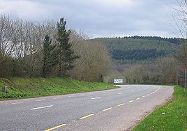
R639 road
Encyclopedia
Republic of Ireland
Ireland , described as the Republic of Ireland , is a sovereign state in Europe occupying approximately five-sixths of the island of the same name. Its capital is Dublin. Ireland, which had a population of 4.58 million in 2011, is a constitutional republic governed as a parliamentary democracy,...
regional road
Regional road
A regional road in Ireland is a class of road not forming a major route , but nevertheless forming a link in the national route network. There are over 11,600 kilometres of regional roads. Regional roads are numbered with three digit route numbers, prefixed by "R" A regional road in Ireland is a...
s. Once designated the N8 national primary road
National primary road
A national primary road is a road classification in the Republic of Ireland. National primary roads form the major routes between the major urban centres. There are over 2,700km of national primary roads. This category of road has the prefix "N" followed by one or two digits...
(and before that some fractions were designated as the T6
Trunk Roads in Ireland
Ireland has an extensive network of public roads which connect all parts of the country with each other. Roads in Ireland are currently classified as motorways, National Primary routes, National secondary routes, Regional roads and Local roads. The introduction of this classification system began...
and others as the T9
Trunk Roads in Ireland
Ireland has an extensive network of public roads which connect all parts of the country with each other. Roads in Ireland are currently classified as motorways, National Primary routes, National secondary routes, Regional roads and Local roads. The introduction of this classification system began...
), it was reclassified in stages as the R639 following the progressive opening of sections of the M8 motorway
M8 motorway (Ireland)
The M8 motorway is an inter-urban motorway in Ireland, which forms part of the road from the capital - Dublin - to Cork city. The 149 km motorway commences in the townland of Aghaboe, County Laois and runs through the counties of Kilkenny, North Tipperary, South Tipperary and Limerick,...
, which rendered the single carriageway N8 redundant as a national primary road. By-passed sections of the old N8 were generally reclassified as R639 as soon a new section of M8 opened, thereby increasing the length of the R639. With the completion of the M8 on 28 May 2010, the R639 now stretches from Durrow, County Laois
Durrow, County Laois
Durrow is a small town located in south County Laois, Ireland. Bypassed by the M8 motorway on 28 May 2010, the town is located on the R639 road at its junction with the N77. The river Erkina flows through Durrow and joins the River Nore about 1.5 km east of the town...
to Cork
Cork (city)
Cork is the second largest city in the Republic of Ireland and the island of Ireland's third most populous city. It is the principal city and administrative centre of County Cork and the largest city in the province of Munster. Cork has a population of 119,418, while the addition of the suburban...
, running through counties Laois
County Laois
County Laois is a county in Ireland. It is part of the Midlands Region and is also located in the province of Leinster. It was formerly known as Queen's County until the establishment of the Irish Free State in 1922. The county's name was formerly spelt as Laoighis and Leix. Laois County Council...
, Kilkenny
County Kilkenny
County Kilkenny is a county in Ireland. It is part of the South-East Region and is also located in the province of Leinster. It is named after the city of Kilkenny. The territory of the county was the core part of the ancient Irish Kingdom of Osraige which in turn was the core of the Diocese of...
, Tipperary
County Tipperary
County Tipperary is a county of Ireland. It is located in the province of Munster and is named after the town of Tipperary. The area of the county does not have a single local authority; local government is split between two authorities. In North Tipperary, part of the Mid-West Region, local...
, Limerick
County Limerick
It is thought that humans had established themselves in the Lough Gur area of the county as early as 3000 BC, while megalithic remains found at Duntryleague date back further to 3500 BC...
and Cork
County Cork
County Cork is a county in Ireland. It is located in the South-West Region and is also part of the province of Munster. It is named after the city of Cork . Cork County Council is the local authority for the county...
.
Route
N77 road (Ireland)
The N77 road is a national secondary road in Ireland. It links the N10 national primary on the ring road south of Kilkenny, County Kilkenny to the N8 national primary road at Durrow in County Laois.-Upgrades and Extensions:...
in Durrow
Durrow, County Laois
Durrow is a small town located in south County Laois, Ireland. Bypassed by the M8 motorway on 28 May 2010, the town is located on the R639 road at its junction with the N77. The river Erkina flows through Durrow and joins the River Nore about 1.5 km east of the town...
in County Laois
County Laois
County Laois is a county in Ireland. It is part of the Midlands Region and is also located in the province of Leinster. It was formerly known as Queen's County until the establishment of the Irish Free State in 1922. The county's name was formerly spelt as Laoighis and Leix. Laois County Council...
to the N8 on the Lower Glanmire Road 1.5 km east north of the Dunkettle Interchange on the outskirts of Cork City.
North to south, it passes through Durrow, Cullahill, Johnstown
Johnstown, County Kilkenny
Johnstown , historically known as Coorthafooka , is a village in County Kilkenny, Ireland. Bypassed in December 2008 by the M8, the town lies at the junction of the R639, the R502 and the R435 regional roads. It is the home of the Fenians GAA hurling club...
, Urlingford
Urlingford
Urlingford is a town in the barony of Galmoy, County Kilkenny, Ireland.The town lies on the R639. The M8 motorway runs just west of the town, from which both Urlingford and nearby Johnstown are accessed via junction four. Urlingford is a bus hub, with major operator JJ Kavanagh and Sons based there...
, Littleton
Littleton, County Tipperary
Littleton is a village in North Tipperary, Ireland. It is within the townlands of Ballybeg and Ballydavid, about northeast of Cashel and to the southeast of Thurles. By-passed by the M8 in December 2008, Littleton lies at a crossroads on the R639 road. Its population was 463 at the 2006 census...
, Horse and Jockey
Horse and Jockey
Horse and Jockey is a village in North Tipperary, Ireland. It lies on the R639 road, where it meets the N62 road to Thurles. It lies just off junction 6 of the M8 motorway, which by-passed the village in December 2008...
, Cashel
Cashel, County Tipperary
Cashel is a town in South Tipperary in Ireland. Its population was 2936 at the 2006 census. The town gives its name to the ecclesiastical province of Cashel. Additionally, the cathedra of the Roman Catholic Archdiocese of Cashel and Emly was originally in the town prior to the English Reformation....
, and New Inn; and from there it runs south-west around Cahir
Cahir
Cahir is a town in South Tipperary in Ireland. The town is best known for its castle and the Swiss Cottage. It is in the barony of Iffa and Offa West.-Location and access:...
and on through Skeheenarinky
Skeheenarinky
Skeheenarinky is a townland in south-west County Tipperary, Ireland.It is a dispersed settlement with a focal point at Skeheenarinky Crosswhere a school, shop and pub are located.-Location:...
before entering County Limerick
County Limerick
It is thought that humans had established themselves in the Lough Gur area of the county as early as 3000 BC, while megalithic remains found at Duntryleague date back further to 3500 BC...
and passing through the village of Kilbeheny
Kilbeheny
Kilbehenny is a village in County Limerick, Ireland, on the R639 regional road. It is situated on the County Cork border and is within two kilometers of the County Tipperary border...
before veering west of Mitchelstown
Mitchelstown
Mitchelstown is a town in County Cork, Ireland with a population of approximately 3300. Mitchelstown is situated in the valley to the south of the Galtee Mountains close to the Mitchelstown Caves and is 28 km from Cahir, 50 km from Cork and 59 km from Limerick...
and proceeding south along Kilworth Mountain and through Fermoy
Fermoy
Fermoy is a town in County Cork, Ireland. It is situated on the River Blackwater in the south of Ireland. Its population is some 5,800 inhabitants, environs included ....
, Rathcormack
Rathcormack
Rathcormack or Rathcormac is a village in County Sligo, Ireland. It is 6 km north of Sligo town on the N15 road between Ben Bulben mountain and the sea.-See also:* List of towns and villages in Ireland...
, Watergrasshill
Watergrasshill
Watergrasshill is a small town in County Cork, Province of Munster, Ireland. The 2006 census recorded a population of 1,068.Bypassed in 2003, the town is situated on the R639 road. It is accessible via junction 17 of the M8 motorway...
, Sallybrook
Sallybrook
Sallybrook is a small village on the outskirts of Cork City, Ireland. It is in the townland of Knocknahorgan on the River Glashaboy . The main village has twenty houses which date back over 150 years, and were originally part of the Smith Barry Estate situated on Fota Island near Cobh, in Cork...
and Glanmire
Glanmire
Glanmire literally meaning ‘The valley of the small fish; The valley of the ploughed land:' The Still Vale: The Valley of the Young Fish) is a town in County Cork, Ireland with a population of 15,498....
, terminating at the N8 Lower Glanmire Road.
History

18th and 19th centuries
In the 17th, 18th and early to mid-19th centuries - and probably earlier still - horse-drawn Dublin-Cork traffic travelled via KilcullenKilcullen
Kilcullen , formally Kilcullen Bridge, is a small town on the River Liffey in County Kildare, Ireland. Its population of 2,985 makes it the 12th largest settlement in County Kildare and the fastest growing in the county, having doubled in population from 1,483 in the census of 2002...
, Carlow
Carlow
Carlow is the county town of County Carlow in Ireland. It is situated in the south-east of Ireland, 84 km from Dublin. County Carlow is the second smallest county in Ireland by area, however Carlow Town is the 14th largest urban area in Ireland by population according to the 2006 census. The...
, Kilkenny
Kilkenny
Kilkenny is a city and is the county town of the eponymous County Kilkenny in Ireland. It is situated on both banks of the River Nore in the province of Leinster, in the south-east of Ireland...
, Clonmel
Clonmel
Clonmel is the county town of South Tipperary in Ireland. It is the largest town in the county. While the borough had a population of 15,482 in 2006, another 17,008 people were in the rural hinterland. The town is noted in Irish history for its resistance to the Cromwellian army which sacked both...
, Ardfinnan
Ardfinnan
Ardfinnan is a small village in the barony of Iffa and Offa West, South Tipperary in Ireland. It is situated on the River Suir and R665 regional road. The parish of Ardfinnan is made up of three areas: Ardfinnan, Ballybacon, and Grange. The village is located 14 kilometres from the town of Clonmel...
, Clogheen
Clogheen
Clogheen is the name of several places in Ireland*Clogheen, County Tipperary*Clogheen, County Waterford*Clogheen, County Cork...
, Ballyporeen
Ballyporeen
Ballyporeen is a village in South Tipperary, Ireland. The latest census of 2006 recorded the population of Ballyporeen at 304 with an additional 573 in its rural hinterland.-Location:...
, Kilworth
Kilworth
Kilworth is a village in north County Cork. It is also one half of the parish of "Kilworth and Araglin" in the Roman Catholic Diocese of Cloyne.-Loation and access:...
, Fermoy
Fermoy
Fermoy is a town in County Cork, Ireland. It is situated on the River Blackwater in the south of Ireland. Its population is some 5,800 inhabitants, environs included ....
and Rathcormac
Rathcormac
Rathcormac is a small town in north County Cork, Ireland. Previously situated on the main Cork to Dublin road , it was bypassed in 2006 by the M8. The former N8 through Main St is now the R639 regional road.-Amenities:...
. Much of the R639/N8 route was built to connect the midlands to southern Tipperary and north County Cork as part of the Irish turnpike
Turnpike trust
Turnpike trusts in the United Kingdom were bodies set up by individual Acts of Parliament, with powers to collect road tolls for maintaining the principal highways in Britain from the 17th but especially during the 18th and 19th centuries...
road-building drive
History of Roads in Ireland
There have been routes and trackways in Ireland connecting settlements and facilitating trade since ancient times and the country now has an extensive network of public roads connecting all parts of the island.-Early history:...
of the mid-18th century. However, some sections are considerably older, such as the segment between Cork and Fermoy, and that between Cashel and Cahir; the construction of these particular stretches cannot as yet be dated, though they were in place prior to 1714. The R639/N8 between Fermoy and Cahir via Mitchelstown was built sometime after 1811, while the R639 between Cashel and Urlingford
Urlingford
Urlingford is a town in the barony of Galmoy, County Kilkenny, Ireland.The town lies on the R639. The M8 motorway runs just west of the town, from which both Urlingford and nearby Johnstown are accessed via junction four. Urlingford is a bus hub, with major operator JJ Kavanagh and Sons based there...
was built around 1739. At the same time, the route from Urlingford to Maryboro (modern-day Portlaoise) was substantially improved. In 1782 an unnamed English tourist in Ireland, known to historians as "X.Z.", gave a brief description of the route between Cashel and Urlingford: "From Cashel we rode fifteen miles of a bad road, through a bleak country to Urlingford, when we enter Leinster
Leinster
Leinster is one of the Provinces of Ireland situated in the east of Ireland. It comprises the ancient Kingdoms of Mide, Osraige and Leinster. Following the Norman invasion of Ireland, the historic fifths of Leinster and Mide gradually merged, mainly due to the impact of the Pale, which straddled...
province. The country now becomes more populous, better improved, and the roads much more agreeable for travelling."
20th and 21st centuries

Trunk Roads in Ireland
Ireland has an extensive network of public roads which connect all parts of the country with each other. Roads in Ireland are currently classified as motorways, National Primary routes, National secondary routes, Regional roads and Local roads. The introduction of this classification system began...
, continued to run from Cork to Cahir, and from there to Dublin via Clonmel, Kilkenny and Carlow. The R639/N8 corridor did not become the official Dublin to Cork road until 1974, though several Esso road atlases considered it to be the preferred route for motorists travelling between the two cities from at least the early 1960s. From this time until the gradual opening of the various M8 motorway
M8 motorway (Ireland)
The M8 motorway is an inter-urban motorway in Ireland, which forms part of the road from the capital - Dublin - to Cork city. The 149 km motorway commences in the townland of Aghaboe, County Laois and runs through the counties of Kilkenny, North Tipperary, South Tipperary and Limerick,...
segments beginning with the Fermoy Bypass in 2006, the route was known as the "N8".
The N8 was improved at various times during the 1970s through to the early years of the 21st century. One of the first improvements entailed a realignment of the road so that it bypassed the village of Glanmire
Glanmire
Glanmire literally meaning ‘The valley of the small fish; The valley of the ploughed land:' The Still Vale: The Valley of the Young Fish) is a town in County Cork, Ireland with a population of 15,498....
for 6 km to the east. This dual carriageway bypass, referred to in official documentation as the "Glanmire Bypass", opened in April 1992 after a construction period of almost 7 years. When this happened, the former T6/N8 through Glanmire was renumbered, for the first time, as the "R639". The next major incident in the modern history of the R639 occurred in 1991, when a new 4 km single-carriageway bypass to the south-west of Cahir
Cahir
Cahir is a town in South Tipperary in Ireland. The town is best known for its castle and the Swiss Cottage. It is in the barony of Iffa and Offa West.-Location and access:...
in County Tipperary
County Tipperary
County Tipperary is a county of Ireland. It is located in the province of Munster and is named after the town of Tipperary. The area of the county does not have a single local authority; local government is split between two authorities. In North Tipperary, part of the Mid-West Region, local...
opened to traffic. This bypass became a part of the N8 for the next 18 years. With the completion of the M8 motorway
M8 motorway (Ireland)
The M8 motorway is an inter-urban motorway in Ireland, which forms part of the road from the capital - Dublin - to Cork city. The 149 km motorway commences in the townland of Aghaboe, County Laois and runs through the counties of Kilkenny, North Tipperary, South Tipperary and Limerick,...
through South Tipperary in July 2008 however, the 1991 N8 Cahir Bypass was renumbered as part of the N24 - while simultaneously becoming the R639. (The original route of the N8 through Cahir town was redesignated a regional road in 1991, and made a part of the R670
R670 road
The R670 road is a regional road in Ireland. The route runs from its junction with the R639 and N24 at Cloughabreeda 2 km north of Cahir through Cahir town and onwards for a further 8 km to Ardfinnan, where it joins the R665 road...
.) Other improvement projects carried out on the road during the 1970s, 80s and 90s involved periodic widening and resurfacing. In spring 2001, attention was turned to Watergrasshill
Watergrasshill
Watergrasshill is a small town in County Cork, Province of Munster, Ireland. The 2006 census recorded a population of 1,068.Bypassed in 2003, the town is situated on the R639 road. It is accessible via junction 17 of the M8 motorway...
in County Cork. For many years regarded as a serious bottleneck on the N8, a wide median 7 km dual carriageway bypass was constructed and opened to traffic in September 2003 as the N8, with the former road through Watergrasshill becoming the R639. In 2004 the N8 through Cashel
Cashel, County Tipperary
Cashel is a town in South Tipperary in Ireland. Its population was 2936 at the 2006 census. The town gives its name to the ecclesiastical province of Cashel. Additionally, the cathedra of the Roman Catholic Archdiocese of Cashel and Emly was originally in the town prior to the English Reformation....
in County Tipperary was realigned with a narrow-median dual carriageway bypass to the east of that town. Again, the former N8 through Cashel was redesignated a regional road, and renumbered the R639. In October 2007 the section of N8 between Cashel and Cahir (the same road mapped by Herman Moll
Herman Moll
Herman Moll , was a cartographer, engraver, and publisher. Moll moved to England in 1678 and opened a book and map store in London...
in 1714) was bypassed by an early-opening segment of the M8 motorway, and became the most recent addition to the R639 route. This, in turn, was followed in July 2008 by the section between Cahir and Kilbehenny; on 8 December 2008 by the length of road from Cashel to 2 km south of Cullahill in County Laois
County Laois
County Laois is a county in Ireland. It is part of the Midlands Region and is also located in the province of Leinster. It was formerly known as Queen's County until the establishment of the Irish Free State in 1922. The county's name was formerly spelt as Laoighis and Leix. Laois County Council...
; on 25 May 2009, by the section between Mitchelstown
Mitchelstown
Mitchelstown is a town in County Cork, Ireland with a population of approximately 3300. Mitchelstown is situated in the valley to the south of the Galtee Mountains close to the Mitchelstown Caves and is 28 km from Cahir, 50 km from Cork and 59 km from Limerick...
and Fermoy
Fermoy
Fermoy is a town in County Cork, Ireland. It is situated on the River Blackwater in the south of Ireland. Its population is some 5,800 inhabitants, environs included ....
; and on 28 May 2010 by the length between Durrow and Cullahill.
Landmarks
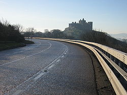
Rock of Cashel
The Rock of Cashel , also known as Cashel of the Kings and St. Patrick's Rock, is a historic site in Ireland's province of Munster, located at Cashel, South Tipperary.-History:...
and famously skirts around its base on its approach to Cashel town. Visible from the R639 too is Hoare Abbey, also close to Cashel. South of Cahir
Cahir
Cahir is a town in South Tipperary in Ireland. The town is best known for its castle and the Swiss Cottage. It is in the barony of Iffa and Offa West.-Location and access:...
the R639 passes southwest along the base of the Galtee Mountains
Galtee Mountains
The Galtee Mountains or Galty Mountains are a mountain range in Munster, located in Ireland's Golden Vale across parts of counties Limerick, South Tipperary and Cork. The name "Galtee" is thought to be a corruption of the Irish "Sléibhte na gCoillte" - "Mountains of the Forests" in English,...
, while to the east, the fertile plain of the Golden Vale
Golden Vale
The Golden Vale is an area of rolling pastureland in the civil province of Munster, southwestern Ireland. Covering parts of three counties, Limerick, Tipperary and Cork, it is the best land in Ireland for dairy farming....
is observable, with the Knockmealdowns
Knockmealdown Mountains
The Knockmealdown Mountains are a mountain range located on the border of counties South Tipperary and Waterford in Ireland, running east and west between the two counties. The highest peak of the range is Knockmealdown, situated in County Waterford...
and Comeragh Mountains
Comeragh Mountains
The Comeragh Mountains are a glaciated mountain range situated in the south east of Ireland in County Waterford. They are located between the town of Clonmel on the County Tipperary border and the villages of Kilrossanty and Kilmacthomas in County Waterford.The twelve mountains which form the...
starkly visible to the east. The R639 also passes by Glengarra Wood
Glengarra Wood
Glengarra Wood is a mixed woodland in Ireland located southwest of Cahir, Co. Tipperary off the M8 motorway and R639 road. Approximately in extent, it is situated on Old Red Sandstone on the southern slopes of the Galtee Mountains. It is mainly a coniferous forest with Sitka Spruce being the main...
and Mitchelstown Cave.
See also
- Roads in IrelandRoads in IrelandThe island of Ireland, comprising Northern Ireland and the Republic of Ireland, has an extensive network of tens of thousands of kilometres of public roads, usually surfaced. These roads have been developed and modernised over centuries, from trackways suitable only for walkers and horses, to...
- Motorways in Ireland
- National primary roadNational primary roadA national primary road is a road classification in the Republic of Ireland. National primary roads form the major routes between the major urban centres. There are over 2,700km of national primary roads. This category of road has the prefix "N" followed by one or two digits...
- National secondary roadNational secondary roadA national secondary road is a category of road in Ireland. These roads form an important part of the national route network, but are secondary to the main arterial routes which are classified as national primary roads. National secondary roads are designated with route numbers higher than those...
- History of roads in IrelandHistory of Roads in IrelandThere have been routes and trackways in Ireland connecting settlements and facilitating trade since ancient times and the country now has an extensive network of public roads connecting all parts of the island.-Early history:...
- Trunk Roads in IrelandTrunk Roads in IrelandIreland has an extensive network of public roads which connect all parts of the country with each other. Roads in Ireland are currently classified as motorways, National Primary routes, National secondary routes, Regional roads and Local roads. The introduction of this classification system began...