

Road signs in the Republic of Ireland
Encyclopedia
Traffic sign
Traffic signs or road signs are signs erected at the side of roads to provide information to road users. With traffic volumes increasing over the last eight decades, many countries have adopted pictorial signs or otherwise simplified and standardized their signs to facilitate international travel...
s used elsewhere in Europe. Directional signage is similar to that of the United Kingdom, but is bilingual. Distances are in kilometre
Kilometre
The kilometre is a unit of length in the metric system, equal to one thousand metres and is therefore exactly equal to the distance travelled by light in free space in of a second...
s. Apart from directional signage, the basic prohibitory signs such as "no left turn" and "no right turn" are among the few standard signs used in Ireland
Republic of Ireland
Ireland , described as the Republic of Ireland , is a sovereign state in Europe occupying approximately five-sixths of the island of the same name. Its capital is Dublin. Ireland, which had a population of 4.58 million in 2011, is a constitutional republic governed as a parliamentary democracy,...
. The most widespread signage, hazard or warning sign
Warning sign
A traffic warning sign is a type of traffic sign that indicates a hazard ahead on the road that may not be readily apparent to a driver.In most countries, they usually take the shape of an equilateral triangle with a white background and a thick red border...
s, employs the yellow diamond layout used in the United States, Canada, Australia and elsewhere, but nowhere else in Europe. The actual symbols used on these warning signs, however, often bear a closer resemblance to those used in the rest of Europe than to those seen in the US. On 20 January 2005, Ireland fully adopted metric speed limits. Around 35,000 existing signs were replaced and a further 23,000 new signs erected bearing the speed limit in kilometres per hour. To avoid confusion with the old signs, each speed limit sign now has "km/h" beneath the numerals.
Irish signs depict classical silhouetted persons.
Legal basis
Signage in Ireland is prescribed under the Traffic Signs Manual 2010 (TSM), issued by the Department of TransportDepartment of Transport (Ireland)
The Department of Transport, Tourism and Sport is a department of the Government of Ireland that is responsible for transport policy and overseeing transport services and infrastructure. The Department is led by the Minister for Transport, Tourism and Sport who is assisted by two Ministers of State...
. Published in late 2010 after a long period of review, this replaced at least one older edition, the Traffic Signs Manual 1996.
Older signs appear in secondary legislation (see the references section at the bottom), however much of the signage (particularly directional signage) used has never been legally prescribed for. The TSM itself is not a law. However, signage is meant to be based on the principles in it. It is partially based (particularly directional signage) on the United Kingdom Traffic Signs Manual, itself based on the Traffic Signs Regulations and General Directions.
Those road signs which are prescribed in law are prescribed under the Road Traffic (Signs) Regulations 1997-2004, the 1997 regulations being the main set which repealed various traffic signs regulations dating back to 1964.
Typefaces and colours

English language
English is a West Germanic language that arose in the Anglo-Saxon kingdoms of England and spread into what was to become south-east Scotland under the influence of the Anglian medieval kingdom of Northumbria...
equivalent place name in all capital
All caps
In typography, all caps refers to text or a font in which all letters are capital letters. All caps is usually used for emphasis. It is commonly seen in the titles on book covers, in advertisements and in newspaper headlines...
letters. The Transport Heavy
Transport (typeface)
Transport is a sans serif typeface designed for road signs in the United Kingdom. It was created between 1957 and 1963 by Jock Kinneir and Margaret Calvert as part of their work as designers for the Department of Transport's Anderson and Worboys committees....
and Motorway
Motorway (typeface)
Motorway is a typeface designed by Jock Kinneir and Margaret Calvert for use on the motorway network of the United Kingdom. It was first used on the M6 Preston bypass in 1958 and has been in use on the UK's motorways since...
typefaces are used, although the Irish language text uses a distinctive oblique
Oblique type
Oblique type is a form of type that slants slightly to the right, used in the same manner as italic type. Unlike italic type, however, it does not use different glyph shapes; it uses the same glyphs as roman type, except distorted...
variant, in which letters a are represented by script a (ɑ), and letters i are represented by dotless i (ı) in order to better differentiate from their accented form. Only the Irish place name is shown if the sign is in the Gaeltacht
Gaeltacht
is the Irish language word meaning an Irish-speaking region. In Ireland, the Gaeltacht, or an Ghaeltacht, refers individually to any, or collectively to all, of the districts where the government recognises that the Irish language is the predominant language, that is, the vernacular spoken at home...
, or the official name in English is identical to the Irish name or nearly so (for example Dún Laoghaire
Dún Laoghaire
Dún Laoghaire or Dún Laoire , sometimes anglicised as "Dunleary" , is a suburban seaside town in County Dublin, Ireland, about twelve kilometres south of Dublin city centre. It is the county town of Dun Laoghaire-Rathdown County and a major port of entry from Great Britain...
or Port Laoise
Port Laoise
Portlaoise or Port Laoise , historically spelled Port Laoighise or Portlaoighise, is the county town of County Laois in the midlands of Ireland. The population was 14,613.-History:...
). Due to the need to signpost in both languages, usually a limited number of destinations will be signposted. If a destination can be reached by following a route which is a spur from that route, the destination and route number will be shown in brackets. Also, distances are shown in kilometres.
Motorway signs use white text on a blue background. Non-motorway national primary routes use white text on a green background, with the specific route number in yellow bold text. Regional and local county roads use black text on white background. Signs to points of interest (services, institutions, tourist sights) have white text on a brown background. Patching (according to the Guildford Rules) is used to show roads of different classification on signs. On all purpose roads, signs for roads whose only destination is a motorway should display the motorway symbol.
Types of sign available
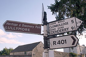
A number of types of sign are available for use on all purpose roads. A properly signed junction will be signed in advance by advance directional signs, which can either be map type (which displays the junction as a pictogram) or stack type, in which the destinations are on separate panels. In Ireland, NRA policy encourages stack type signs at normal intersections (such as T-junctions or crossroads), with map-type signs used mainly for roundabouts and for grade-separated junctions. However map-type signs are occasionally used at normal intersections where it is necessary to sign a restriction (such as a weight or height restriction). At the junction itself, either a flag sign - a sign with a triangular point at one end and a chevron - or (on rural roads) a fingerpostFingerpost
A fingerpost is a name given to traditional British and Irish sign posts comprising a post with one or more arms — known as fingers — pointing in the direction of travel to named places on the fingers...
points the driver in the direction to be taken. After the junction, a route confirmation sign listing the route number and the primary destinations will be erected.
However, on rural roads, it is common for some or all of the above signage to be missing. Often junctions are signed with only a fingerpost.
Destination signing policy
One feature of road signage in Ireland, particularly along Dublin's quays, is that some national primary road signage directs drivers generically to destinations such as "The West" and "The South" and "The North". This system, inherited from the UK system, was banned under the 1996 TSM, which mandates the use of the terminal destination and next primary destination of the route instead, but signage was patched with specific destinations only in the early 2000s. While this has been replaced with specific placenames in some cases, it remains in use in other areas. In summer 2006, signage for "North" and "South" was erected in Ashbourne at the start of the new N2 dual carriageway. Nevertheless, generally directional signage on major routes shows major or end destinations. Smaller towns and placenames are shown only on signage nearer to that location. Thus, travelling on the Irish route network requires some geographical knowledge of the country.Original design
The original design (1983–1989) of Irish motorway signage was a simpler version of the UK design. These signs were only ever in use on the M7 Naas Bypass and M1 Airport Motorway and only rare examples are still in situ.From 1989-2005, signage on motorways was nearly identical to that on UK motorways (but see new motorway signage, below); although in the Ireland, motorway junctions were not always numbered, or the number was not always signposted. The sign at the actual exit, which in the UK shows the road number to be reached, was replaced by a flag sign with the destination instead. On the M50
M50 motorway (Ireland)
The M50 motorway is a motorway in Ireland running in a C-shaped ring around the north-eastern, northern, western and southern sides of the capital city, Dublin. The northern end of the route is located at the entrance to the Dublin Port Tunnel. Anti-clockwise it heads northwest through the tunnel...
, in the case of junctions with national routes, the initial advance direction sign was replaced with a list of destinations for that national route. The 1989 design of signs can still be seen on older sections of the M4 and M7.
2005-2007
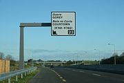
In 2005, upon the opening of the South Eastern Motorway section of the M50, the National Roads AuthorityNational Roads Authority
The National Roads Authority is a state body in the Republic of Ireland, responsible for the national road network. The NRA was established as part of the Roads Act 1993 and commenced operations on 23 December 1993 in accordance with S.I. 407 of 1993.County councils remain responsible for local...
erected new style gantry signage. The new signage retained typical colours and fonts buts differed from older side of road signage in that it used separate overhead panels for each lane, headed with the route number in each case as well as new half-gantry signs closer to the exit. The new signage was also erected on the N2 Finglas
Finglas
-See also:* List of towns and villages in Ireland* List of abbeys and priories in Ireland...
– Ashbourne
Ashbourne, County Meath
Ashbourne, historically called Killeglan or Kildeglan , is a town in County Meath, Ireland. It is about 20 km north of Dublin city centre and is bypassed by the M2 motorway.-History:...
scheme and N7 Clondalkin
Clondalkin
-Today:Modern Clondalkin is a busy satellite town of Dublin, with a population of 43,929 in 2006. Retail facilities include Tesco Ireland- and Dunnes Stores-led shopping centres, and Aldi and Lidl stores on the Fonthill Road and New Nangor Road respectively, and the village centre is a base for...
– Naas
Naas
Naas is the county town of County Kildare in Ireland. With a population of just over twenty thousand, it is also the largest town in the county. Naas is a major commuter suburb, with many people residing there and working in Dublin...
scheme. These were the first roads in Ireland where overhead gantry signage has been used as a matter of course, instead of just very major junctions. Drivers are given clear advanced warning 1 km ahead of an upcoming junction. A half gantry at the junction then directed them to their destination. The new style signage is visually clearer than older type signage with drivers able to read the gantry signage from a distance of approximately 300m on a straight stretch of road. Despite its significant advantages, the new gantry signage caused confusion because the downward arrows over the left traffic lanes seemed to indicate to drivers that they should pull out into the right lane if they wish to continue on the motorway or dual carriageway, breaking the keep left rule.
Current signing policy
In July 2007, some of the gantry signage on the M50 between Junctions 13–17 erected in 2005 was replaced with signage in a revised style, reverting to a single panel over the mainline. By March 2008 all the 2005 style gantries had been removed from the M50 (and were later removed from the N2 and N7). The one aspect of the 2005 scheme that was retained is the half-gantry (or cantilever) sign just before the exit, which has now also been extended to other roads. A second change introduced in 2007 is that the flag sign at the gore, which previously listed the primary destinations to be reached, now features the junction number and the word "Exit" instead. This revised scheme has been used on most motorway and high quality dual carriageway schemes since 2007. The "Next Exit" signs listing destinations, which were originally used only on the M50, are now extended to other motorways.Thus the sequence of signage at a motorway junction in Ireland on motorways opened since 2007 (and older motorways which have been re-signed) is as follows:
- "Next Exit" sign at 2 km listing primary destinations to be reached by this exit.
- 1 km - Advance directional sign (map type) or gantry in lieu
- 500m - Advance directional sign (map type) or gantry in lieu
- 100m - Cantilever sign
- Gore - "Exit" sign with junction number
- 500m following exit - route confirmation sign.
To this day the Ireland continues to use the "Motorway Ahead" sign, listing the motorway regulations.
This new signage has now been formally adopted with the publication of the 2010 TSM.
Warning signs
Warning signs are similar to the United States design, in that they are black on an amber (orangish yellow) background, and are diamond shaped. Road worksRoadworks
Roadworks occur when part of the road, or in rare cases, the entire road, has to be occupied for work relating to the road, most often in the case of road surface repairs...
hazard signs are reddish orange. This type of road sign was introduced in 1956 with the Traffic Signs Regulations, 1956. Some signs were added later, and many types of signs, even common ones, do not appear in any statutes. Some types of sign in particular (for example, pedestrian/zebra crossing signage) are somewhat randomly designed, and differ between county/city boroughs.
The "low bridge" sign was the last road sign with an imperial measurement allowed to be erected in Ireland, and was only replaced with a metric only version with the publication of the 2010 TSM. Most examples of this sign in situ are still the dual imperial/metric version, with the imperial only version still in situ is some locations.
 Dangerous corner |
 Dangerous bend |
 Series of dangerous corners |
 Series of dangerous bends |
 Junction at corner with a minor road |
 Junction at a bend with a minor road |
 Crossroads with roads of equal importance |
 Junction with side-road of equal importance |
 T-junction with roads of equal importance |
Y-junction with roads of equal importance |
 Staggered crossroads with roads of equal importance |
Staggered crossroads with minor roads |
Crossroads with a minor road |
 Junction with a minor side-road |
 Crossroads with a major road |
T-junction with a major road |
 Junction with dual-carriageway |
Crossroad with dual-carriageway |
End of dual-carriageway |
Two-way traffic resumes ahead |
Two lanes ahead |
Merge to single lane ahead |
Single lane only |
 Roundabout ahead |
 Traffic lights ahead |
 Unguarded level crossing |
 Level crossing with gates |
 Level crossing with automatic gates |
 Sharp rise ahead |
 Sharp depression ahead |
 Series of sharp rises or depressions ahead |
 Steep decline ahead |
 Steep incline ahead |
Road narrows ahead |
 Slippery surface |
Unprotected quay |
 (School) children crossing |
Children (pedestrians) crossing |
Traffic queues |
Road works ahead |
 Bridge height ahead |
Crosswinds |
Falling rocks |
Road narrows from the right ahead |
Trams crossing |
Tunnel ahead |
Wild animals |
Regulatory signs
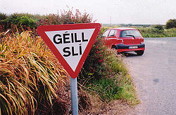
In Ireland, the "Give Way" sign, a downward pointing triangle, reads "Yield" (on signs erected prior to 1997: "Yield Right of Way" ) or, in Gaeltacht
Gaeltacht
is the Irish language word meaning an Irish-speaking region. In Ireland, the Gaeltacht, or an Ghaeltacht, refers individually to any, or collectively to all, of the districts where the government recognises that the Irish language is the predominant language, that is, the vernacular spoken at home...
areas, "Géill Slí". A blank inverted triangle was provided for in legislation applicable between 1956 and 1961. The international octagonal "Stop" sign is also used.
Speed limit signs have the speed with the letters "km/h" underneath. 120 km/h is used for motorways and high quality dual carriageways e.g. N2, 100 km/h is used for national primary and national secondary roads and also part the R132 in Co.Louth. 80 km/h is used for regional and local roads. 60, 50 and 30 km/h are used in urban built up areas (see Road speed limits in Ireland
Road speed limits in the Republic of Ireland
Road speed limits in the Republic of Ireland apply on all public roads in the country. These are signposted and legislated for in kilometres per hour. Speed limits are demarcated by regulatory road signs . These consist of white circular signs with a red outline. Speed limits are marked in black...
). There are no longer any "end of speed limit" signs in Ireland (a white circle with black diagonal line as used in the UK). 40 mph signs are still present at the main exit of Shannon Airport
Shannon Airport
Shannon Airport, is one of the Republic of Ireland's three primary airports along with Dublin and Cork. In 2010 around 1,750,000 passengers passed through the airport, making it the third busiest airport in the Republic of Ireland after Dublin and Cork, and the fifth busiest airport on the island...
.
Although differing from the design originally laid down (see Regulatory Signs below), "Keep Left" and "Keep Right" signs are now mostly white on a blue background, on the British pattern. In order to avail themselves of standard designs from British suppliers, local authorities had made extensive use of the white-on-blue design, mostly because the electronically lit type of white-on-blue was more practical, in consequence of which legislation was enacted making both patterns legal. Under the Irish Power of One (energy conservation campaign) the electronic signs are being gradually replaced by reflective signs. The former "No Entry" sign, a prohibititon sign with an upward pointing arrow, was replaced with the international standard red disk in TSM 2010. However the older version, now termed "No Straight Ahead", may be used when combined with a time or other restriction.
Signage shown in the table below is not relative size in all cases. Images are based on sizes presented in different ages of legislation. Actual signage may be found in varying sizes, with the 1994 regulations finally setting three definitive sets of metric dimensions for each sign. Larger signs are used on motorways, dual-carriageways, major junctions, etc.
No straight ahead |
Right turn only |
No U-turn |
Stop |
Yield (to other traffic ahead) |
Géill Slí (Yield sign in Irish) |
Keep right |
 No left turn |
 No right turn |
Turn right ahead |
Speed limit |
No parking |
No stopping |
No overtaking |
No entry for weight |
Height restriction |
Yield" "To Oncoming Traffic |
No vehicles |
Earlier directional signage
The former "fingerpostFingerpost
A fingerpost is a name given to traditional British and Irish sign posts comprising a post with one or more arms — known as fingers — pointing in the direction of travel to named places on the fingers...
" style of Irish directional signage can still be seen in many areas of rural Ireland. These signs differ from their modern day equivalent as they have black raised text on a white background. Destinations are in all caps (the Irish letter is simply smaller than the English one). Sometimes, the former route number ("T" for trunk road, "L" for link road) can be seen, and the former Bord Failte
Fáilte Ireland
Fáilte Ireland is the National Tourism Development Authority of the Republic of Ireland. This authority was established under the National Tourism Development Authority Act of 2003 and replaces and builds upon the functions of Bord Fáilte, its predecessor organization...
logo can be seen on some (they had responsibility for signage for a time), as well as occasionally a harp. Distances on these signs are in miles.
This style of signage has become a common feature of many tourist images of Ireland and can be seen in some Irish pubs. However, they can be easily rotated, and have been done so on occasion and therefore are not completely reliable. While most examples of these signs still in situ are rural finger-posts, the advance directional sign of this era can still very occasionally be seen: this has a grey background, with the destinations in outlined, white-background boxes linked together with black lines, and the text is not raised on these, unlike on fingerposts. These signs, rare even when the system was in use, can be seen in some areas of Dún Laoghaire
Dún Laoghaire
Dún Laoghaire or Dún Laoire , sometimes anglicised as "Dunleary" , is a suburban seaside town in County Dublin, Ireland, about twelve kilometres south of Dublin city centre. It is the county town of Dun Laoghaire-Rathdown County and a major port of entry from Great Britain...
and Drogheda
Drogheda
Drogheda is an industrial and port town in County Louth on the east coast of Ireland, 56 km north of Dublin. It is the last bridging point on the River Boyne before it enters the Irish Sea....
. These signs were prescribed under various regulations, with the final design prescribed under the Road Traffic Signs (Regulations) 1962.
Despite the new signage style being introduced in 1977, the design change was never legislated (with only a reference to the change to italics in 1989) for and the old signage design was repealed only under the 1997 regulations, 20 years later.
The first generation of the current signage system, introduced in 1977, can also be seen in on some national roads (and also on the oldest stretch of the M1). This is similar to the current system, but the signs are simpler, a different shade of green is used, and the Irish place names are not in italics. These signs were directly based on the Worboys Committee
Worboys Committee
The Worboys Committee was formed by the British government in July 1963 to review signage on all British roads. This was in response to two articles published in 1961 by graphic designer Herbert Spencer, illustrating the shortcomings of non-motorway British road signs.The committee was chaired by...
designs which had been adopted in the UK in 1965. These signs were replaced by the current system on 1 January 1989. The design of signs has continued to evolve with the introduction of patching under the Guildford Rules in 1994 and the introduction of cantilever
Cantilever
A cantilever is a beam anchored at only one end. The beam carries the load to the support where it is resisted by moment and shear stress. Cantilever construction allows for overhanging structures without external bracing. Cantilevers can also be constructed with trusses or slabs.This is in...
directional signs in 2005, as well as the expansion in gantry signage since then.
The Irish "Yield" sign formerly read "Yield Right of Way", and many of this older variant can still be seen around the country.
Earlier warning signs
Before adoption of the 1956 traffic signs regulations, warning signs accorded to a standard laid out in the 1926 "Road Signs and Traffic Signals Regulations" (see References, below). These signs, unlikely to exist in situ anywhere in Ireland nowadays, were similar to signs used in the United Kingdom at that time.The signs were cast-iron plates, with raised type painted black on white. A square pictogram illustrated the hazard, and the type of hazard was written in both Irish, with traditional typeface, and English. A hollow red triangle normally surmounted the pole to which the sign was attached.
See also
- Roads in IrelandRoads in IrelandThe island of Ireland, comprising Northern Ireland and the Republic of Ireland, has an extensive network of tens of thousands of kilometres of public roads, usually surfaced. These roads have been developed and modernised over centuries, from trackways suitable only for walkers and horses, to...
- Motorways in the Republic of IrelandMotorways in the Republic of IrelandIn Ireland, the highest category of road is a Motorway , indicated by the prefix M followed by one or two digits...
- National primary roadNational primary roadA national primary road is a road classification in the Republic of Ireland. National primary roads form the major routes between the major urban centres. There are over 2,700km of national primary roads. This category of road has the prefix "N" followed by one or two digits...
- National secondary roadNational secondary roadA national secondary road is a category of road in Ireland. These roads form an important part of the national route network, but are secondary to the main arterial routes which are classified as national primary roads. National secondary roads are designated with route numbers higher than those...
- Regional roadRegional roadA regional road in Ireland is a class of road not forming a major route , but nevertheless forming a link in the national route network. There are over 11,600 kilometres of regional roads. Regional roads are numbered with three digit route numbers, prefixed by "R" A regional road in Ireland is a...
- Local Roads in IrelandLocal Roads in IrelandA Local Road in Ireland is a class of public road not classified as a National road or as a Regional road but nevertheless forming a link in the national network of roads...
- Atlantic CorridorAtlantic CorridorThe Atlantic Corridor is a road project in Ireland that eventually will link Waterford in the South-East to Letterkenny in the North-West by high-quality dual carriageway or motorway. A major infrastructure project, the scheme was announced as part of the Transport 21 project launch in 2005, and is...
- Dublin Port TunnelDublin Port TunnelThe Dublin Port Tunnel is a road traffic tunnel in Dublin, Ireland, that forms part of the M50 motorway....
- Jack Lynch TunnelJack Lynch TunnelThe Jack Lynch Tunnel is an immersed tube tunnel and an integral part of the N25 southern ring road of Cork in Ireland. It is named after former Taoiseach, Jack Lynch, a native of Cork....
- History of Roads in IrelandHistory of Roads in IrelandThere have been routes and trackways in Ireland connecting settlements and facilitating trade since ancient times and the country now has an extensive network of public roads connecting all parts of the island.-Early history:...
- Trunk Roads in IrelandTrunk Roads in IrelandIreland has an extensive network of public roads which connect all parts of the country with each other. Roads in Ireland are currently classified as motorways, National Primary routes, National secondary routes, Regional roads and Local roads. The introduction of this classification system began...
- National Roads AuthorityNational Roads AuthorityThe National Roads Authority is a state body in the Republic of Ireland, responsible for the national road network. The NRA was established as part of the Roads Act 1993 and commenced operations on 23 December 1993 in accordance with S.I. 407 of 1993.County councils remain responsible for local...
- Road speed limits in the Republic of IrelandRoad speed limits in the Republic of IrelandRoad speed limits in the Republic of Ireland apply on all public roads in the country. These are signposted and legislated for in kilometres per hour. Speed limits are demarcated by regulatory road signs . These consist of white circular signs with a red outline. Speed limits are marked in black...
- Vehicle registration plates of Ireland
- Northern Irish Vehicle Registration Plates
- Transport in IrelandTransport in IrelandMost of the transport system in Ireland is in public hands, either side of the Irish border. The Irish road network has evolved separately in the two jurisdictions Ireland is divided up into, while the Irish rail network was mostly created prior to the partition of Ireland.In the Republic of...
- List of Ireland-related topics
External links
- A copy of the "Transport"Transport (typeface)Transport is a sans serif typeface designed for road signs in the United Kingdom. It was created between 1957 and 1963 by Jock Kinneir and Margaret Calvert as part of their work as designers for the Department of Transport's Anderson and Worboys committees....
font is available here, free of charge.