
.gif)
M50 motorway (Ireland)
Encyclopedia
The M50 motorway is a motorway in Ireland
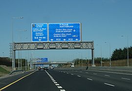
running in a C-shaped ring around the north-eastern, northern, western and southern sides of the capital city, Dublin. The northern end of the route is located at the entrance to the Dublin Port Tunnel
. Anti-clockwise it heads northwest through the tunnel and then veers west at a junction with the M1 motorway. It crosses the dual West-Link
toll bridges over the River Liffey
in west Dublin, and forms a loop around the south-east of Dublin to meet the M11 route (running south to Wexford) at Shankill, County Dublin
. Between Junctions 3 to 13 the road forms part of European route E01
.
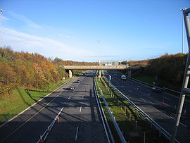
The M50 was first proposed in the Dublin Transportation Study of 1971. Construction began on the first part of the M50, the Western Parkway, in 1987. This section of the M50, between Junctions 6 (Blanchardstown) and 11 (Tallaght), opened to traffic in 1990. This was followed in 1996 by the Northern Cross section between Junctions 6 and 3 and the Southern Cross between Junctions 11 and 13 which opened in 2001. The completed M50 motorway was formally opened on 30 June 2005, and later the Dublin Port Tunnel, which was opened on 20 December 2006, was included as part of the route.
Work commenced in early 2006 on upgrading earlier sections of motorway. Many of the grade-separated signal-controlled roundabout interchange
s were replaced with free-flowing junctions and the road from the M1 junction to Sandyford
was widened to three lanes in each direction with a fourth auxiliary lane provided between junctions.
On Sunday 7th Feb 2010, the M50 Southern Cross was opened up to 3 lanes in each direction from J10 Ballymount to J14 Sandyford. This followed a week after the Northern Cross opened from J3 M1 to J6 N3. The M50 is now 3 lanes in each direction from J3 M1 to J14 Sandyford, with auxiliary lanes between all junctions from the M1 to Firhouse
 The M50 was originally planned to divert traffic traveling on National Primary Routes away from the city (a full bypass of Dublin). Due to urban expansion it now runs through Dublin's suburbs and serves a route for Dublin itself, connecting the suburbs.
All of the National Primary Routes leaving Dublin have junctions with the M50. The intersections were originally in the form of grade-separated signal-controlled roundabout
junctions, not free-flowing interchange
s. The M50 mainline itself was free-flow through all junctions. The other primary routes served are the N2 to Derry
/Monaghan
, N3 to Navan
/Cavan
/Northwest, N4/M4 to Galway
/Sligo, N7/M7 (M8
) to Cork
/Limerick
/Waterford
, and the N11/M11 to Wexford
. Additional junctions along the motorway serve other suburbs of Dublin such as Ballymun
, Tallaght
, Naas
, Dundrum
, Sandyford and Cherrywood
.
Most of these interchanges were subject to high levels of traffic congestion, as was the former toll-plaza north of the West-Link bridge. The busier roundabout junctions were signal-controlled, with tailbacks extending for several kilometres at rush hour
. The most infamous was the Red Cow roundabout
junction with the N7, formerly dubbed the "Mad Cow Roundabout". As well as being the junction of two of the busiest roads in the State, the Luas
tram Red Line from Tallaght to the city centre used to cross two slip roads at-grade, before continuing city-bound in the median of the R110 (formerly N7). As part of the M50 upgrade works (see below), these at-grade crossings were removed, and on December 2008, the completely reconstructed interchange was open. This greatly reduced the congestion at the once-notorious traffic blackspot.
The roundabout at the N3 is also notable as the Royal Canal
and the Dublin-Sligo railway line
pass through its centre.
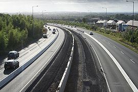
The original speed limit on the M50 was 70 mph (112 km/h) which was increased to 120 km/h when all speed limits in the Republic of Ireland became metric in 2005. The Southern Cross Route (the extension from Junction 12 to Junction 14) was given a lower limit of 60 mph (96 km/h) with a decimal limit of 100 km/h after 2005. This was because of its more undulating terrain, tighter and more frequent curves and resulting shorter sight lines. Because of the doubling of the number of running lanes along most of the route, which has shortened sight lines and increased lane changing, and due of the high number of junctions, the entire length of the route has (with the exception of the sections from Junction 1 to Junction 3 and Junction 14 to 17) the same speed limit, of 100 km/h, since it was completely upgraded (2007–10).
The section of the route which was previously the M1 from Junction 1 to Junction 3 (which is now the M50 up to the port tunnel
) retains a speed limit of 80 km/h due to the closely packed junctions, and because of the high number and frequency of lane changes that are required among all manner of vehicles depending on their intended route. For example, traffic traveling Southbound on the M50 approaching the Dublin Port Tunnel
must cross 2-3 lanes of traffic to avoid its portals. Whilst in the opposite direction, traffic exiting the tunnel must cross 3 lanes to continue on the M50 rather than progress onto the M1.
The South Eastern Motorway section, a radial route, was originally meant to be part of the M11. It curves away from the city centre and instead joins the N11 at junction 17 heading south. The next opportunity to exit the motorway at the Bray North
exit of the M11.
There is no Junction 8, the junction number having being reserved for a potential extension of the M7 motorway from Lucan/Clondalkin to Naas. This is unlikely to be built given that the N7 Naas Road has been upgraded to dual three lane with at grade junctions converted to grade-separated interchanges or left-in, left-out (LILOs)
junctions. However, it is an objective of South Dublin County Council to construct a new junction and use to it provide local access to the Cloverhill area of Palmerstown
. This is also very unlikely to happen as the NRA have stated they are against the provision of new interchanges on the existing M50 as they are seen to contribute to traffic congestion on the route and undermine its function as a motorway.
 Completion of Dublin's ring road by the building of an Eastern Bypass of the city has been proposed. This plan is controversial, as it would require a tunnel across Sandymount Strand
to or possibly through Booterstown marsh
bird sanctuary. A motorway reservation from Sandyford to Booterstown
has been included in the Dun Laoghaire-Rathdown
Development Plan, with space allowed for an interchange where it crosses the N11. The Dublin Port Tunnel
, which opened on 20 December 2006, would form the northern half of the Eastern bypass.
Another outer orbital road
has been proposed for the Dublin region. It will, if approved, run approximately from Drogheda
via Navan
, Trim
and Kilcock
towards Naas
.
Republic of Ireland
Ireland , described as the Republic of Ireland , is a sovereign state in Europe occupying approximately five-sixths of the island of the same name. Its capital is Dublin. Ireland, which had a population of 4.58 million in 2011, is a constitutional republic governed as a parliamentary democracy,...
running in a C-shaped ring around the north-eastern, northern, western and southern sides of the capital city, Dublin. The northern end of the route is located at the entrance to the Dublin Port Tunnel
Dublin Port Tunnel
The Dublin Port Tunnel is a road traffic tunnel in Dublin, Ireland, that forms part of the M50 motorway....
. Anti-clockwise it heads northwest through the tunnel and then veers west at a junction with the M1 motorway. It crosses the dual West-Link
West-Link
The West-Link is a toll bridge on the M50 motorway to the west of Dublin, Ireland, operated by BetEire Flow Limited for the National Roads Authority.- Structure :...
toll bridges over the River Liffey
River Liffey
The Liffey is a river in Ireland, which flows through the centre of Dublin. Its major tributaries include the River Dodder, the River Poddle and the River Camac. The river supplies much of Dublin's water, and a range of recreational opportunities.-Name:The river was previously named An Ruirthech,...
in west Dublin, and forms a loop around the south-east of Dublin to meet the M11 route (running south to Wexford) at Shankill, County Dublin
County Dublin
County Dublin is a county in Ireland. It is part of the Dublin Region and is also located in the province of Leinster. It is named after the city of Dublin which is the capital of Ireland. County Dublin was one of the first of the parts of Ireland to be shired by King John of England following the...
. Between Junctions 3 to 13 the road forms part of European route E01
European route E01
The European route E 01 is a series of roads in Europe, part of the United Nations International E-road network, running from Larne, Northern Ireland to Seville, Spain. There is a sea crossing between Rosslare Harbour, in Ireland, and Ferrol, but no ferry service...
.
The M50 was first proposed in the Dublin Transportation Study of 1971. Construction began on the first part of the M50, the Western Parkway, in 1987. This section of the M50, between Junctions 6 (Blanchardstown) and 11 (Tallaght), opened to traffic in 1990. This was followed in 1996 by the Northern Cross section between Junctions 6 and 3 and the Southern Cross between Junctions 11 and 13 which opened in 2001. The completed M50 motorway was formally opened on 30 June 2005, and later the Dublin Port Tunnel, which was opened on 20 December 2006, was included as part of the route.
Work commenced in early 2006 on upgrading earlier sections of motorway. Many of the grade-separated signal-controlled roundabout interchange
Roundabout interchange
A roundabout interchange is a type of interchange between a controlled access highway such as a motorway or freeway, and a minor road, in which the slip roads to and from the motorway carriageways converge at a single roundabout, which is grade-separated from the motorway lanes with bridges...
s were replaced with free-flowing junctions and the road from the M1 junction to Sandyford
Sandyford
Sandyford is a suburb of Dublin, located in Dún Laoghaire-Rathdown County, Ireland. A major part of Sandyford today is composed of the Sandyford Industrial Estate and related developments.- Location and access :...
was widened to three lanes in each direction with a fourth auxiliary lane provided between junctions.
On Sunday 7th Feb 2010, the M50 Southern Cross was opened up to 3 lanes in each direction from J10 Ballymount to J14 Sandyford. This followed a week after the Northern Cross opened from J3 M1 to J6 N3. The M50 is now 3 lanes in each direction from J3 M1 to J14 Sandyford, with auxiliary lanes between all junctions from the M1 to Firhouse
Layout
All of the National Primary Routes leaving Dublin have junctions with the M50. The intersections were originally in the form of grade-separated signal-controlled roundabout
Roundabout
A roundabout is the name for a road junction in which traffic moves in one direction around a central island. The word dates from the early 20th century. Roundabouts are common in many countries around the world...
junctions, not free-flowing interchange
Interchange (road)
In the field of road transport, an interchange is a road junction that typically uses grade separation, and one or more ramps, to permit traffic on at least one highway to pass through the junction without directly crossing any other traffic stream. It differs from a standard intersection, at which...
s. The M50 mainline itself was free-flow through all junctions. The other primary routes served are the N2 to Derry
Derry
Derry or Londonderry is the second-biggest city in Northern Ireland and the fourth-biggest city on the island of Ireland. The name Derry is an anglicisation of the Irish name Doire or Doire Cholmcille meaning "oak-wood of Colmcille"...
/Monaghan
Monaghan
Monaghan is the county town of County Monaghan in Ireland. Its population at the 2006 census stood at 7,811 . The town is located on the main road, the N2 road, from Dublin north to both Derry and Letterkenny.-Toponym:...
, N3 to Navan
Navan
-People:Navan was the childhood home of Pierce Brosnan, who appeared in the television series Remington Steele and was the fifth film actor to play James Bond. TV personality Hector Ó hEochagáin, and comedians Dylan Moran and Tommy Tiernan also hail from Navan....
/Cavan
Cavan
Cavan is the county town of County Cavan in the Republic of Ireland. The town lies in the north central part of Ireland, near the border with Northern Ireland...
/Northwest, N4/M4 to Galway
Galway
Galway or City of Galway is a city in County Galway, Republic of Ireland. It is the sixth largest and the fastest-growing city in Ireland. It is also the third largest city within the Republic and the only city in the Province of Connacht. Located on the west coast of Ireland, it sits on the...
/Sligo, N7/M7 (M8
M8 motorway (Ireland)
The M8 motorway is an inter-urban motorway in Ireland, which forms part of the road from the capital - Dublin - to Cork city. The 149 km motorway commences in the townland of Aghaboe, County Laois and runs through the counties of Kilkenny, North Tipperary, South Tipperary and Limerick,...
) to Cork
Cork (city)
Cork is the second largest city in the Republic of Ireland and the island of Ireland's third most populous city. It is the principal city and administrative centre of County Cork and the largest city in the province of Munster. Cork has a population of 119,418, while the addition of the suburban...
/Limerick
Limerick
Limerick is the third largest city in the Republic of Ireland, and the principal city of County Limerick and Ireland's Mid-West Region. It is the fifth most populous city in all of Ireland. When taking the extra-municipal suburbs into account, Limerick is the third largest conurbation in the...
/Waterford
Waterford
Waterford is a city in the South-East Region of Ireland. It is the oldest city in the country and fifth largest by population. Waterford City Council is the local government authority for the city and its immediate hinterland...
, and the N11/M11 to Wexford
Wexford
Wexford is the county town of County Wexford, Ireland. It is situated near the southeastern corner of Ireland, close to Rosslare Europort. The town is connected to Dublin via the M11/N11 National Primary Route, and the national rail network...
. Additional junctions along the motorway serve other suburbs of Dublin such as Ballymun
Ballymun
Ballymun is an area on Dublin's Northside close to Dublin Airport, Ireland. It is infamous for the Ballymun flats, which became a symbol of poverty, drugs, alienation from the state and social problems in Ireland from the 1970s...
, Tallaght
Tallaght
Tallaght is the largest town, and county town, of South Dublin County, Ireland. The village area, dating from at least the 17th century, held one of the earliest settlements known in the southern part of the island, and one of medieval Ireland's more important monastic centres.Up to the 1960s...
, Naas
Naas
Naas is the county town of County Kildare in Ireland. With a population of just over twenty thousand, it is also the largest town in the county. Naas is a major commuter suburb, with many people residing there and working in Dublin...
, Dundrum
Dundrum, Dublin
Dundrum , originally a town in its own right, is now a suburb of Dublin in Dún Laoghaire-Rathdown, Ireland.The area is located in the postal districts of Dublin 14 and Dublin 16.-History:...
, Sandyford and Cherrywood
Cherrywood
Cherrywood is one of Dublin's newest suburbs, withhin Loughlinstown, and bordering Rathmichael, to the south east of the city, in the County of Dun Laoghaire-Rathdown...
.
Most of these interchanges were subject to high levels of traffic congestion, as was the former toll-plaza north of the West-Link bridge. The busier roundabout junctions were signal-controlled, with tailbacks extending for several kilometres at rush hour
Rush hour
A rush hour or peak hour is a part of the day during which traffic congestion on roads and crowding on public transport is at its highest. Normally, this happens twice a day—once in the morning and once in the evening, the times during when the most people commute...
. The most infamous was the Red Cow roundabout
Red Cow roundabout
The Red Cow interchange is a major road junction in west Dublin, Ireland on the M50, meeting the N7 Naas Road at a free-flow grade separated junction which incorporates a light railway line...
junction with the N7, formerly dubbed the "Mad Cow Roundabout". As well as being the junction of two of the busiest roads in the State, the Luas
Luas
Luas , also promoted in the development stage as the Dublin Light Rail System, is a tram or light rail system serving Dublin, the first such system in the decades since the closure of the last of the Dublin tramways. In 2007, the system carried 28.4 million passengers, a growth of 10% since...
tram Red Line from Tallaght to the city centre used to cross two slip roads at-grade, before continuing city-bound in the median of the R110 (formerly N7). As part of the M50 upgrade works (see below), these at-grade crossings were removed, and on December 2008, the completely reconstructed interchange was open. This greatly reduced the congestion at the once-notorious traffic blackspot.
The roundabout at the N3 is also notable as the Royal Canal
Royal Canal of Ireland
The Royal Canal is a canal originally built for freight and passenger transportation from the River Liffey at Dublin to the River Shannon at Cloondara in County Longford in Ireland. It fell into disrepair, but since has been restored for navigation...
and the Dublin-Sligo railway line
Dublin-Sligo railway line
The Dublin to Sligo line is a main line railway route operated by Iarnród Éireann in the Republic of Ireland. It starts in Dublin Connolly station, terminating at Mac Diarmada railway station in Sligo...
pass through its centre.
The original speed limit on the M50 was 70 mph (112 km/h) which was increased to 120 km/h when all speed limits in the Republic of Ireland became metric in 2005. The Southern Cross Route (the extension from Junction 12 to Junction 14) was given a lower limit of 60 mph (96 km/h) with a decimal limit of 100 km/h after 2005. This was because of its more undulating terrain, tighter and more frequent curves and resulting shorter sight lines. Because of the doubling of the number of running lanes along most of the route, which has shortened sight lines and increased lane changing, and due of the high number of junctions, the entire length of the route has (with the exception of the sections from Junction 1 to Junction 3 and Junction 14 to 17) the same speed limit, of 100 km/h, since it was completely upgraded (2007–10).
The section of the route which was previously the M1 from Junction 1 to Junction 3 (which is now the M50 up to the port tunnel
Dublin Port Tunnel
The Dublin Port Tunnel is a road traffic tunnel in Dublin, Ireland, that forms part of the M50 motorway....
) retains a speed limit of 80 km/h due to the closely packed junctions, and because of the high number and frequency of lane changes that are required among all manner of vehicles depending on their intended route. For example, traffic traveling Southbound on the M50 approaching the Dublin Port Tunnel
Dublin Port Tunnel
The Dublin Port Tunnel is a road traffic tunnel in Dublin, Ireland, that forms part of the M50 motorway....
must cross 2-3 lanes of traffic to avoid its portals. Whilst in the opposite direction, traffic exiting the tunnel must cross 3 lanes to continue on the M50 rather than progress onto the M1.
Exit list
| M50 Motorway | ||
| Southbound | Junction | Northbound |
| Start of motorway Terminals 1&2 | 1 | End of motorway Dublin Port Dublin Port Dublin Port is Ireland's biggest sea port. It has both historical and contemporary economic importance. Approximatively two-thirds of the Republic of Ireland's port traffic goes via Dublin Port... Terminals 1&2 |
| Dublin Port Tunnel Dublin Port Tunnel The Dublin Port Tunnel is a road traffic tunnel in Dublin, Ireland, that forms part of the M50 motorway.... Toll (free for HGVs & buses) |
||
| No exit | 2 | Coolock Coolock Coolock is a large suburban area, centred on a village, on Dublin city's Northside in Ireland. Coolock is crossed by the Santry River, a prominent feature in the middle of the district, with a linear park and ponds... , Santry Santry Santry is a suburb on the Northside of Dublin, Ireland, bordering Coolock, Glasnevin and Ballymun. Today it straddles the boundary of Dublin City and Fingal County Council area.... R104, City Centre N1 Non-Tunnel traffic |
| Belfast Belfast Belfast is the capital of and largest city in Northern Ireland. By population, it is the 14th biggest city in the United Kingdom and second biggest on the island of Ireland . It is the seat of the devolved government and legislative Northern Ireland Assembly... , Dublin Airport Dublin Airport Dublin Airport, , is operated by the Dublin Airport Authority. Located in Collinstown, in the Fingal part of County Dublin, 18.4 million passengers passed through the airport in 2010, making it the busiest airport in the Republic of Ireland, followed by Cork and Shannon... M1, (Malahide Malahide Malahide is a coastal suburban town, near Dublin city, located in the administrative county of Fingal, within the traditional County Dublin, Ireland. It has a village-like centre and extensive residential areas to the south, west and northwest.-Name:... ) N32 (R107) |
3 | Belfast Belfast Belfast is the capital of and largest city in Northern Ireland. By population, it is the 14th biggest city in the United Kingdom and second biggest on the island of Ireland . It is the seat of the devolved government and legislative Northern Ireland Assembly... , Dublin Airport Dublin Airport Dublin Airport, , is operated by the Dublin Airport Authority. Located in Collinstown, in the Fingal part of County Dublin, 18.4 million passengers passed through the airport in 2010, making it the busiest airport in the Republic of Ireland, followed by Cork and Shannon... M1, (Malahide Malahide Malahide is a coastal suburban town, near Dublin city, located in the administrative county of Fingal, within the traditional County Dublin, Ireland. It has a village-like centre and extensive residential areas to the south, west and northwest.-Name:... ) N32 (R107) |
| Ballymun Ballymun Ballymun is an area on Dublin's Northside close to Dublin Airport, Ireland. It is infamous for the Ballymun flats, which became a symbol of poverty, drugs, alienation from the state and social problems in Ireland from the 1970s... R108 R108 road The R108 road is a regional road in Ireland, linking Drogheda in County Louth to the N2 in Phibsborough, Dublin.The official description of the R108 from the Roads Act 1993 Order 2006 reads:The road is long.... Ballymun Road |
4 | Ballymun Ballymun Ballymun is an area on Dublin's Northside close to Dublin Airport, Ireland. It is infamous for the Ballymun flats, which became a symbol of poverty, drugs, alienation from the state and social problems in Ireland from the 1970s... R108 R108 road The R108 road is a regional road in Ireland, linking Drogheda in County Louth to the N2 in Phibsborough, Dublin.The official description of the R108 from the Roads Act 1993 Order 2006 reads:The road is long.... Ballymun Road, Santry Avenue , IKEA IKEA IKEA is a privately held, international home products company that designs and sells ready-to-assemble furniture such as beds and desks, appliances and home accessories. The company is the world's largest furniture retailer... |
| Finglas Finglas -See also:* List of towns and villages in Ireland* List of abbeys and priories in Ireland... , Phibsboro Phibsboro Phibsborough , often formerly shortened to Phibsboro and later Phibsboro , is a district of Dublin in Ireland.-Location:Phibsboro' is located in the Dublin 7 postal district on the Northside of the city. The area is very close to the city centre, about two kilometres from the River Liffey which... , Dublin N2 (R135 R135 road The R135 road is one of Ireland's newest regional roads, being a reclassification of those sections of the former N2 which were bypassed when the N2 Ashbourne By-Pass dual carriageway opened in 2006, and when the Carrickmacross, Castleblayney & Monaghan bypasses were completed.-References:* – ... ) |
5 | (Ashbourne) Ashbourne, County Meath Ashbourne, historically called Killeglan or Kildeglan , is a town in County Meath, Ireland. It is about 20 km north of Dublin city centre and is bypassed by the M2 motorway.-History:... , Derry Derry Derry or Londonderry is the second-biggest city in Northern Ireland and the fourth-biggest city on the island of Ireland. The name Derry is an anglicisation of the Irish name Doire or Doire Cholmcille meaning "oak-wood of Colmcille"... N2 (R135 R135 road The R135 road is one of Ireland's newest regional roads, being a reclassification of those sections of the former N2 which were bypassed when the N2 Ashbourne By-Pass dual carriageway opened in 2006, and when the Carrickmacross, Castleblayney & Monaghan bypasses were completed.-References:* – ... ) North Road , Finglas Road |
| Cabra Cabra, Dublin Cabra is a suburb on the northside of Dublin city in Ireland. It is approximately northwest of the city centre, in the administrative area of Dublin City Council. It was commonly known as Cabragh until the early 20th century.- Transport and access:... , City Centre N3 (Blanchardstown Bypass) Tyrrelstown Tyrrelstown Tyrrelstown is a rapidly expanding village located 13 km northwest of the city of Dublin in Ireland. The local authority for the area, which forms part of the Dublin 15 postal district, is Fingal County Council.-History:... Boulevard |
6 | Castleknock Castleknock Castleknock is a suburb of Dublin, Ireland. It is in the west of the modern administrative county of Fingal within the traditional county of Dublin. It is located west of the centre of Dublin.... , Blanchardstown Blanchardstown Blanchardstown is a large suburb of Dublin in the district of Fingal, Ireland. It is within the historical barony of Castleknock. It is located 10 km north-west of the city centre. The suburb is in the Dublin 15 postal area, the Dublin West electoral constituency, and Fingal County... , The NORTH WEST N3 Navan Road , Phoenix Park Phoenix Park Phoenix Park is an urban park in Dublin, Ireland, lying 2–4 km west of the city centre, north of the River Liffey. Its 16 km perimeter wall encloses , one of the largest walled city parks in Europe. It includes large areas of grassland and tree-lined avenues, and since the seventeenth... Tyrrelstown Tyrrelstown Tyrrelstown is a rapidly expanding village located 13 km northwest of the city of Dublin in Ireland. The local authority for the area, which forms part of the Dublin 15 postal district, is Fingal County Council.-History:... Boulevard |
| West-Link West-Link The West-Link is a toll bridge on the M50 motorway to the west of Dublin, Ireland, operated by BetEire Flow Limited for the National Roads Authority.- Structure :... Toll bridge (now free flow) |
||
| Palmerstown Palmerstown Palmerstown , occasionally referred to as Palmerston, is a suburb of Dublin,Ireland. It is located about 8km west of the city centre, in the administrative county of South Dublin. The area is bordered to the north by the River Liffey, to the west by Lucan, to the south by Ballyfermot and to theeast... , Lucan, The WEST N4 (N5-M6) (Lucan Road) |
7 | Palmerstown Palmerstown Palmerstown , occasionally referred to as Palmerston, is a suburb of Dublin,Ireland. It is located about 8km west of the city centre, in the administrative county of South Dublin. The area is bordered to the north by the River Liffey, to the west by Lucan, to the south by Ballyfermot and to theeast... , Lucan, The WEST N4 (N5-M6) Chapelizod Bypass, Con Colbert Road, Victoria Quay. |
| Clondalkin Clondalkin -Today:Modern Clondalkin is a busy satellite town of Dublin, with a population of 43,929 in 2006. Retail facilities include Tesco Ireland- and Dunnes Stores-led shopping centres, and Aldi and Lidl stores on the Fonthill Road and New Nangor Road respectively, and the village centre is a base for... , Naas Naas Naas is the county town of County Kildare in Ireland. With a population of just over twenty thousand, it is also the largest town in the county. Naas is a major commuter suburb, with many people residing there and working in Dublin... , Crumlin Crumlin, Dublin Crumlin is suburb in Southside Dublin, Ireland. It is the site of Ireland's largest hospital for children.-Location:Crumlin covers the area from the River Poddle near the KCR to the Drimnagh Road, to Bunting Road, and is situated not far from the city centre, on the Southside of Dublin city.... R110 R110 road The R110 road is a regional road in Ireland which goes from St Stephen's Green to Red Cow, Dublin. Its route is completely within the Dublin urban area.... , The SOUTH N7 (M8-M9) Naas Naas Naas is the county town of County Kildare in Ireland. With a population of just over twenty thousand, it is also the largest town in the county. Naas is a major commuter suburb, with many people residing there and working in Dublin... Road, Monastery Road, Newlands Cross , Belgard Road, Luas Luas Luas , also promoted in the development stage as the Dublin Light Rail System, is a tram or light rail system serving Dublin, the first such system in the decades since the closure of the last of the Dublin tramways. In 2007, the system carried 28.4 million passengers, a growth of 10% since... Park n Ride , Kingswood Interchange , Citywest. |
9 | Clondalkin Clondalkin -Today:Modern Clondalkin is a busy satellite town of Dublin, with a population of 43,929 in 2006. Retail facilities include Tesco Ireland- and Dunnes Stores-led shopping centres, and Aldi and Lidl stores on the Fonthill Road and New Nangor Road respectively, and the village centre is a base for... , Naas Naas Naas is the county town of County Kildare in Ireland. With a population of just over twenty thousand, it is also the largest town in the county. Naas is a major commuter suburb, with many people residing there and working in Dublin... , Crumlin Crumlin, Dublin Crumlin is suburb in Southside Dublin, Ireland. It is the site of Ireland's largest hospital for children.-Location:Crumlin covers the area from the River Poddle near the KCR to the Drimnagh Road, to Bunting Road, and is situated not far from the city centre, on the Southside of Dublin city.... R110 R110 road The R110 road is a regional road in Ireland which goes from St Stephen's Green to Red Cow, Dublin. Its route is completely within the Dublin urban area.... , The SOUTH N7 (M8-M9) Naas Naas Naas is the county town of County Kildare in Ireland. With a population of just over twenty thousand, it is also the largest town in the county. Naas is a major commuter suburb, with many people residing there and working in Dublin... Road, Long Mile Road, Walkinstown Walkinstown Walkinstown is a suburb of Dublin, Ireland, situated on the Southside of the city, approximately 6 kilometres south-west of Dublin city centre. The suburb borders Crumlin to the east, Drimnagh to the north, Greenhills to the south and Ballymount, Bluebell and Clondalkin to the west... Avenue. |
| Ballymount Ballymount Ballymount , is located on the south side of Dublin, near the mainly residential areas of Walkinstown to the east, Tallaght to the west and Greenhills to the south... R838 Parkhill Heights Boulevard |
10 | Ballymount Ballymount Ballymount , is located on the south side of Dublin, near the mainly residential areas of Walkinstown to the east, Tallaght to the west and Greenhills to the south... R838 Parkhill Heights Boulevard |
| Tallaght Tallaght Tallaght is the largest town, and county town, of South Dublin County, Ireland. The village area, dating from at least the 17th century, held one of the earliest settlements known in the southern part of the island, and one of medieval Ireland's more important monastic centres.Up to the 1960s... , Templeogue Templeogue Templeogue is a suburb of southwest Dublin, Ireland. The original Irish name Teach Mealóg refers to a chapel named after Saint Mel that was built there in about 1273.... , Blessington Blessington Blessington, historically known as Ballycomeen , is a town in County Wicklow, Ireland. It is located on the N81 road, which connects Dublin to Tullow.- History :... , Tullow Tullow Tullow is a town in County Carlow, Ireland. It is located on the River Slaney where the N81 road intersects with the R762.-History:There is a statue of Father John Murphy, one of the leaders of the 1798 Rebellion, who was captured near Tullow and executed in the Market Square on 2 July... N81 Templeogue Road, Springfield Avenue. |
11 | Tallaght Tallaght Tallaght is the largest town, and county town, of South Dublin County, Ireland. The village area, dating from at least the 17th century, held one of the earliest settlements known in the southern part of the island, and one of medieval Ireland's more important monastic centres.Up to the 1960s... , Templeogue Templeogue Templeogue is a suburb of southwest Dublin, Ireland. The original Irish name Teach Mealóg refers to a chapel named after Saint Mel that was built there in about 1273.... , Blessington Blessington Blessington, historically known as Ballycomeen , is a town in County Wicklow, Ireland. It is located on the N81 road, which connects Dublin to Tullow.- History :... , Tullow Tullow Tullow is a town in County Carlow, Ireland. It is located on the River Slaney where the N81 road intersects with the R762.-History:There is a statue of Father John Murphy, one of the leaders of the 1798 Rebellion, who was captured near Tullow and executed in the Market Square on 2 July... N81 Tallaght Tallaght Tallaght is the largest town, and county town, of South Dublin County, Ireland. The village area, dating from at least the 17th century, held one of the earliest settlements known in the southern part of the island, and one of medieval Ireland's more important monastic centres.Up to the 1960s... Bypass. |
| Firhouse Firhouse Firhouse is a small outer suburb of Dublin, in South Dublin County, Ireland, developed from what was historically a rural village. It is located just south of the River Dodder, and is in the postal district of Dublin 24... , Knocklyon Knocklyon Knocklyon is a suburb of Dublin in Ireland, situated south west of Dublin city, and north of the Dublin Mountains.There is currently a debate among locals whether the correct name is cnoc linn, or cnoc liamhna.... , (R113 R113 road The R113 road is a regional road in Ireland. Located in the east of Ireland at Dublin, it forms a semi-orbital route around the south of the city. As of 2007, clockwise, it starts at the N31 at Temple Hill in Blackrock and ends at a junction with the N4 at Palmerstown.The road is one of the... ) |
12 | Firhouse Firhouse Firhouse is a small outer suburb of Dublin, in South Dublin County, Ireland, developed from what was historically a rural village. It is located just south of the River Dodder, and is in the postal district of Dublin 24... , Knocklyon Knocklyon Knocklyon is a suburb of Dublin in Ireland, situated south west of Dublin city, and north of the Dublin Mountains.There is currently a debate among locals whether the correct name is cnoc linn, or cnoc liamhna.... , (R113 R113 road The R113 road is a regional road in Ireland. Located in the east of Ireland at Dublin, it forms a semi-orbital route around the south of the city. As of 2007, clockwise, it starts at the N31 at Temple Hill in Blackrock and ends at a junction with the N4 at Palmerstown.The road is one of the... ) |
| Dundrum Dundrum, Dublin Dundrum , originally a town in its own right, is now a suburb of Dublin in Dún Laoghaire-Rathdown, Ireland.The area is located in the postal districts of Dublin 14 and Dublin 16.-History:... (R826 R826 road The R826 road is a regional road in south Dublin, Ireland. The road runs from the Dundrum junction of the M50 as passes through or near Ballinteer, Dundrum and Balally before terminating at the junction with the R112 close to Goatstown... ), Sandyford Sandyford Sandyford is a suburb of Dublin, located in Dún Laoghaire-Rathdown County, Ireland. A major part of Sandyford today is composed of the Sandyford Industrial Estate and related developments.- Location and access :... (R133 R133 road The R133 road is a regional road in south Dublin, Ireland. The road starts at Goatstown and runs in a southerly direction towards Sandyford before acting as a link road for the M50.- Route :... ), Ballinteer Ballinteer Ballinteer is a southside suburb of Dublin, located in Dun Laoghaire-Rathdown county, Ireland, extensively developed from the late 1960s onwards.- History :... (R113 R113 road The R113 road is a regional road in Ireland. Located in the east of Ireland at Dublin, it forms a semi-orbital route around the south of the city. As of 2007, clockwise, it starts at the N31 at Temple Hill in Blackrock and ends at a junction with the N4 at Palmerstown.The road is one of the... ) |
13 | Dundrum Dundrum, Dublin Dundrum , originally a town in its own right, is now a suburb of Dublin in Dún Laoghaire-Rathdown, Ireland.The area is located in the postal districts of Dublin 14 and Dublin 16.-History:... (R826 R826 road The R826 road is a regional road in south Dublin, Ireland. The road runs from the Dundrum junction of the M50 as passes through or near Ballinteer, Dundrum and Balally before terminating at the junction with the R112 close to Goatstown... ), Sandyford Sandyford Sandyford is a suburb of Dublin, located in Dún Laoghaire-Rathdown County, Ireland. A major part of Sandyford today is composed of the Sandyford Industrial Estate and related developments.- Location and access :... , Dun Laoghaire Dún Laoghaire Dún Laoghaire or Dún Laoire , sometimes anglicised as "Dunleary" , is a suburban seaside town in County Dublin, Ireland, about twelve kilometres south of Dublin city centre. It is the county town of Dun Laoghaire-Rathdown County and a major port of entry from Great Britain... N31 |
| Dun Laoghaire Dún Laoghaire Dún Laoghaire or Dún Laoire , sometimes anglicised as "Dunleary" , is a suburban seaside town in County Dublin, Ireland, about twelve kilometres south of Dublin city centre. It is the county town of Dun Laoghaire-Rathdown County and a major port of entry from Great Britain... N31 |
14 | No exit |
| Leopardstown Leopardstown Leopardstown is a district in Dun Laoghaire-Rathdown County, Ireland, located at the foot of the Dublin Mountains. A residential suburb of the greater Dublin area, it is divided by the course of the M50 motorway, and adjoins the neighbouring areas of Sandyford, Stepaside, Ballyogan, Foxrock and... / Carrickmines Carrickmines Carrickmines is suburb of Dublin in Dun Laoghaire-Rathdown, Ireland. Traditionally a location for large expensive houses, being situated just south of Foxrock. The area is now divided north/south by the M50 motorway and its associated Junction 15... |
15 | Leopardstown Leopardstown Leopardstown is a district in Dun Laoghaire-Rathdown County, Ireland, located at the foot of the Dublin Mountains. A residential suburb of the greater Dublin area, it is divided by the course of the M50 motorway, and adjoins the neighbouring areas of Sandyford, Stepaside, Ballyogan, Foxrock and... / Carrickmines Carrickmines Carrickmines is suburb of Dublin in Dun Laoghaire-Rathdown, Ireland. Traditionally a location for large expensive houses, being situated just south of Foxrock. The area is now divided north/south by the M50 motorway and its associated Junction 15... |
| Loughlinstown Loughlinstown Loughlinstown is a south Dublin suburb. Located in the County of Dun Laoghaire-Rathdown it lies on the N11 National Primary Route.Loughlinstown is the location of St. Columcille's Hospital, which serves both south Dublin and north Wicklow... , Shankill Shankill, Dublin Shankill is a suburb in the South-East of Dublin located in Dún Laoghaire-Rathdown County, Ireland. It has a population of 13,242 .-History:-Name:... N11 (Northbound) |
16 | Loughlinstown Loughlinstown Loughlinstown is a south Dublin suburb. Located in the County of Dun Laoghaire-Rathdown it lies on the N11 National Primary Route.Loughlinstown is the location of St. Columcille's Hospital, which serves both south Dublin and north Wicklow... / Cherrywood Cherrywood Cherrywood is one of Dublin's newest suburbs, withhin Loughlinstown, and bordering Rathmichael, to the south east of the city, in the County of Dun Laoghaire-Rathdown... |
| Motorway continues as M11 for The SOUTH EAST | 17 (M11 exit 4) |
Shankill Shankill, Dublin Shankill is a suburb in the South-East of Dublin located in Dún Laoghaire-Rathdown County, Ireland. It has a population of 13,242 .-History:-Name:... , Dublin M11 |
The South Eastern Motorway section, a radial route, was originally meant to be part of the M11. It curves away from the city centre and instead joins the N11 at junction 17 heading south. The next opportunity to exit the motorway at the Bray North
Bray
Bray is a town in north County Wicklow, Ireland. It is a busy urban centre and seaside resort, with a population of 31,901 making it the fourth largest in Ireland as of the 2006 census...
exit of the M11.
There is no Junction 8, the junction number having being reserved for a potential extension of the M7 motorway from Lucan/Clondalkin to Naas. This is unlikely to be built given that the N7 Naas Road has been upgraded to dual three lane with at grade junctions converted to grade-separated interchanges or left-in, left-out (LILOs)
Right-in/right-out
Right-in/right-out and left-in/left-out refer to a type of road intersection where turning movements of vehicles are restricted. A RIRO permits only right turns and a LILO permits only left turns. RIRO is usual where vehicles drive on the right, and LILO is usual where vehicles drive on the left...
junctions. However, it is an objective of South Dublin County Council to construct a new junction and use to it provide local access to the Cloverhill area of Palmerstown
Palmerstown
Palmerstown , occasionally referred to as Palmerston, is a suburb of Dublin,Ireland. It is located about 8km west of the city centre, in the administrative county of South Dublin. The area is bordered to the north by the River Liffey, to the west by Lucan, to the south by Ballyfermot and to theeast...
. This is also very unlikely to happen as the NRA have stated they are against the provision of new interchanges on the existing M50 as they are seen to contribute to traffic congestion on the route and undermine its function as a motorway.
Future plans
Sandymount Strand
Sandymount Strand is a large strand on the east coast of Ireland, adjacent to the village and suburb of Sandymount in Dublin. The strand, which is part of the South Bull, is a major component of the south side of Dublin Bay.Sandymount Strand is a popular place for locals to take a walk...
to or possibly through Booterstown marsh
Booterstown marsh
Booterstown Marsh Nature Reserve is located in Booterstown, County Dublin between the coastal railway line and the Rock Road. It is a salt marsh with brackish water, covering an area of approximately 4.3 ha...
bird sanctuary. A motorway reservation from Sandyford to Booterstown
Booterstown
Booterstown,, is a coastal townland and civil parish, situated in the Dún Laoghaire Rathdown County Council area of the former County Dublin, about south of the city of Dublin in Ireland.-Location and access:...
has been included in the Dun Laoghaire-Rathdown
Dun Laoghaire-Rathdown
Dún Laoghaire–Rathdown is a county in Ireland. It is one of three smaller counties into which County Dublin was divided in 1994. Located to the south-east of Dublin city, its county seat is the town of Dún Laoghaire. It is one of the four constituent parts of the Dublin Region...
Development Plan, with space allowed for an interchange where it crosses the N11. The Dublin Port Tunnel
Dublin Port Tunnel
The Dublin Port Tunnel is a road traffic tunnel in Dublin, Ireland, that forms part of the M50 motorway....
, which opened on 20 December 2006, would form the northern half of the Eastern bypass.
Another outer orbital road
Outer Orbital Route
The Outer Orbital Route is a proposed motorway that is to be built sometime between 2011 and 2019, around the city of Dublin, Ireland. It will serve as a second bypass of the city to complement the M50 road and will link all of Dublin's main trunk routes: M1, M2, M3, M4, and M7. The only route that...
has been proposed for the Dublin region. It will, if approved, run approximately from Drogheda
Drogheda
Drogheda is an industrial and port town in County Louth on the east coast of Ireland, 56 km north of Dublin. It is the last bridging point on the River Boyne before it enters the Irish Sea....
via Navan
Navan
-People:Navan was the childhood home of Pierce Brosnan, who appeared in the television series Remington Steele and was the fifth film actor to play James Bond. TV personality Hector Ó hEochagáin, and comedians Dylan Moran and Tommy Tiernan also hail from Navan....
, Trim
Trim, County Meath
Trim is the traditional county town of County Meath in Ireland, although the county town is now Navan. The town was recorded in the 2006 census to have a population of 6,870....
and Kilcock
Kilcock
Kilcock or Killcock is a town and townland in the north of County Kildare, Ireland, on the border with County Meath. Kilcock is a dormitory town for many of those who work in Dublin...
towards Naas
Naas
Naas is the county town of County Kildare in Ireland. With a population of just over twenty thousand, it is also the largest town in the county. Naas is a major commuter suburb, with many people residing there and working in Dublin...
.
See also
- Roads in IrelandRoads in IrelandThe island of Ireland, comprising Northern Ireland and the Republic of Ireland, has an extensive network of tens of thousands of kilometres of public roads, usually surfaced. These roads have been developed and modernised over centuries, from trackways suitable only for walkers and horses, to...
- Motorways in Ireland
- National secondary roadNational secondary roadA national secondary road is a category of road in Ireland. These roads form an important part of the national route network, but are secondary to the main arterial routes which are classified as national primary roads. National secondary roads are designated with route numbers higher than those...
- Regional roadRegional roadA regional road in Ireland is a class of road not forming a major route , but nevertheless forming a link in the national route network. There are over 11,600 kilometres of regional roads. Regional roads are numbered with three digit route numbers, prefixed by "R" A regional road in Ireland is a...
- European route E01European route E01The European route E 01 is a series of roads in Europe, part of the United Nations International E-road network, running from Larne, Northern Ireland to Seville, Spain. There is a sea crossing between Rosslare Harbour, in Ireland, and Ferrol, but no ferry service...
External links
- Roads Act 1993 (Classification of National Roads) Order 2006 – Department of TransportDepartment of Transport (Ireland)The Department of Transport, Tourism and Sport is a department of the Government of Ireland that is responsible for transport policy and overseeing transport services and infrastructure. The Department is led by the Minister for Transport, Tourism and Sport who is assisted by two Ministers of State...
- M50 Motorway Upgrade
- Environmental Impact Statement on M50 Upgrade Scheme
- eFlow