

National primary road
Encyclopedia
Road
A road is a thoroughfare, route, or way on land between two places, which typically has been paved or otherwise improved to allow travel by some conveyance, including a horse, cart, or motor vehicle. Roads consist of one, or sometimes two, roadways each with one or more lanes and also any...
classification in the Republic of Ireland
Republic of Ireland
Ireland , described as the Republic of Ireland , is a sovereign state in Europe occupying approximately five-sixths of the island of the same name. Its capital is Dublin. Ireland, which had a population of 4.58 million in 2011, is a constitutional republic governed as a parliamentary democracy,...
. National primary roads form the major routes between the major urban centres. There are over 2,700km of national primary roads. This category of road has the prefix "N" followed by one or two digits. By contrast, the motorway category has theprefix "M" followed by one or two digits.
Description
Port
A port is a location on a coast or shore containing one or more harbors where ships can dock and transfer people or cargo to or from land....
s and airports) to the network, while N32 and N33 are feeder routes to major motorways (the M50 and M1 respectively). National secondary road
National secondary road
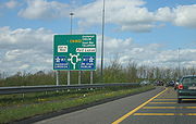
A national secondary road is a category of road in Ireland. These roads form an important part of the national route network, but are secondary to the main arterial routes which are classified as national primary roads. National secondary roads are designated with route numbers higher than those...
s (see next section) are numbered under the same scheme with higher numbers (from N51 on). On road signage, destinations served but not on the route in question are listed in brackets, with the connecting route also listed (see thumbnail). Directional road signs
Road signs in the Republic of Ireland
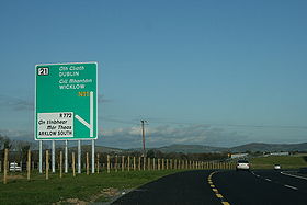
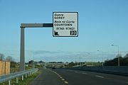
Road signs in Ireland mostly differ from the traffic signs used elsewhere in Europe. Directional signage is similar to that of the United Kingdom, but is bilingual. Distances are in kilometres. Apart from directional signage, the basic prohibitory signs such as "no left turn" and "no right turn"...
on national primary roads are usually in white text on a green background, with the road number in yellow. Signs for roads of different standard are shown using appropriately coloured patches according to a system derived from the UK's Guildford Rules.
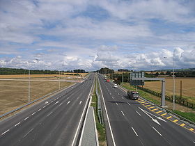
Most national primary roads are of at least wide two lane
Super two
A super two, super two-lane highway or wide two lane is a two-lane surface road built to high standards, typically including partial control of access, occasional passing lanes and hard shoulders...
standard, with sections within Greater Dublin and near the regional cities typically being at least dual-carriageway standard. There are however some narrow two-lane sections remaining.
Northern Ireland route sections (which are classified separately according to NI schemes) are in some cases included in a theoretical complete cross-border route – for example the N3 route, which re-enters the Republic. These are listed here in brackets for completeness (and are present on southern road signage).
Sections of some national primary roads form part of the European route (E-route) network
International E-road network
The international E-road network is a numbering system for roads in Europe developed by the United Nations Economic Commission for Europe . The network is numbered from E 1 up and its roads cross national borders...
. Sections of the N25, N11 and N1 roads form the Republic of Ireland part of route E1
European route E01
The European route E 01 is a series of roads in Europe, part of the United Nations International E-road network, running from Larne, Northern Ireland to Seville, Spain. There is a sea crossing between Rosslare Harbour, in Ireland, and Ferrol, but no ferry service...
(or E01); sections of the N7, N18 and N19 roads form part of route E20
European route E20
The European route E 20 is part of the United Nations International E-road network.It runs roughly west-east through Ireland, the United Kingdom, Denmark, Sweden, Estonia and finally Russia. The length is . The road is not continuous, at three points, a sea crossing is required. ...
; the N8 forms part of route E201 and sections of the N25 form part of route E30
European route E30
European route E 30 is an A-Class West-East European route, extending from the southern Irish port of Cork in the west to the Russian city of Omsk in the east...
. E-route numbers have recently been placed on some route confirmation signs
Reassurance marker
A reassurance marker or road identification sign is a road sign that repeats the name or number of the current route. Typically posted at intervals alongside a numbered highway, the signs are intended to reassure drivers that they are traveling on the desired road .- North America :In the United...
on newer sections of some of these roads.
History
Trunk Roads in Ireland
Ireland has an extensive network of public roads which connect all parts of the country with each other. Roads in Ireland are currently classified as motorways, National Primary routes, National secondary routes, Regional roads and Local roads. The introduction of this classification system began...
for details). The introduction of a National Route numbering system had been discussed since the late 1960s. Legislation to allow its introduction was passed in 1974: the Local Government (Roads and Motorways) Act 1974, which introduced the concepts of motorways and national roads into Irish law. The routes of the original 25 national primary roads were defined via Statutory Instrument
Statutory Instrument
A Statutory Instrument is the principal form in which delegated or secondary legislation is made in Great Britain.Statutory Instruments are governed by the Statutory Instruments Act 1946. They replaced Statutory Rules and Orders, made under the Rules Publication Act 1893, in 1948.Most delegated...
(the Local Government (Roads and Motorways) Act, 1974 (Declaration of National Roads) Order, 1977) in 1977 and the new numbers began to appear on road signs
Road signs in the Republic of Ireland
Road signs in Ireland mostly differ from the traffic signs used elsewhere in Europe. Directional signage is similar to that of the United Kingdom, but is bilingual. Distances are in kilometres. Apart from directional signage, the basic prohibitory signs such as "no left turn" and "no right turn"...
shortly thereafter, with the N4 road and N6 road the first to be signed. The first motorway, the M7 Naas
Naas
Naas is the county town of County Kildare in Ireland. With a population of just over twenty thousand, it is also the largest town in the county. Naas is a major commuter suburb, with many people residing there and working in Dublin...
bypass, opened in 1983.
Since the introduction of the National Route numbering system, the system has remained relatively unchanged in its overall design, although as new bypasses open the various routes themselves have undergone changes. The legislative basis for the system changed in 1993 with the Roads Act 1993. This act introduced a major change: a new body, the National Roads Authority
National Roads Authority
The National Roads Authority is a state body in the Republic of Ireland, responsible for the national road network. The NRA was established as part of the Roads Act 1993 and commenced operations on 23 December 1993 in accordance with S.I. 407 of 1993.County councils remain responsible for local...
(NRA), was set up to manage the national road network. It also made motorways integral parts of national routes (previously they had been a separate classification) and introduced the new classifications of Regional road
Regional road
A regional road in Ireland is a class of road not forming a major route , but nevertheless forming a link in the national route network. There are over 11,600 kilometres of regional roads. Regional roads are numbered with three digit route numbers, prefixed by "R" A regional road in Ireland is a...
and local road
Local Roads in Ireland
A Local Road in Ireland is a class of public road not classified as a National road or as a Regional road but nevertheless forming a link in the national network of roads...
. In 1994, three national secondary roads (N57, N64, N79) were reclassified as national primary roads and subsequently renumbered (N57 to N26, N64 to part N18, N79 to N30) while a section of the N60
N60 road (Ireland)
The N60 road is a national secondary road in Ireland, linking Castlebar, County Mayo to Roscommon town. The quality of the road varies significantly, with County Roscommon having a better alignment. The worst section of the route is between Castlebar and Claremorris where some stretches are...
between Castlebar
Castlebar
Castlebar is the county town of, and at the centre of, County Mayo in Ireland. It is Mayo's largest town by population. The town's population exploded in the late 1990s, increasing by one-third in just six years, though this massive growth has slowed down greatly in recent years...
and Westport
Westport, County Mayo
Westport is a town in County Mayo, Ireland. It is situated on the west coast at the south-east corner of Clew Bay, an inlet of the Atlantic Ocean....
in Co. Mayo was reclassified as the N5. Four other national primary routes (N27, N28, N29, N31) were added to the network: a section of the R600 regional road between Cork city centre and Cork Airport was reclassified as the N27, the N28 was partly newly constructed and partly a reclassified section of regional road (R609), the N29 was newly constructed and the N31 was made up of roads previously classified as regional roads. The N32, which had been constructed from new as an extension of the M50 Northern Cross Route
M50 motorway (Ireland)
The M50 motorway is a motorway in Ireland running in a C-shaped ring around the north-eastern, northern, western and southern sides of the capital city, Dublin. The northern end of the route is located at the entrance to the Dublin Port Tunnel. Anti-clockwise it heads northwest through the tunnel...
project became part of the system in 1996. The N33 also became part of the system in the late 1990s, although it was only defined in the current definition of the state's national roads, the Roads Act 1993 (Classification of National Roads) Order 2006. To date it remains the newest national primary road. Route numbers N34 to N49 remain unallocated.
Upgrages to motorway status and high quality dual carriageways
National Development Plan
National Development Plan is the title given by the Irish Government to a scheme of organised large-scale expenditure on national infrastructure. The period covered by the seven year plan runs from 2000 to 2006. A second National Development Plan is currently in progress and is due to run until...
, the major national motorways - the N6 from Dublin to the Border, N6 (along with that section of the N4 leading to it) Dublin to Galway
Galway
Galway or City of Galway is a city in County Galway, Republic of Ireland. It is the sixth largest and the fastest-growing city in Ireland. It is also the third largest city within the Republic and the only city in the Province of Connacht. Located on the west coast of Ireland, it sits on the...
, N7 Dublin to Limerick
Limerick
Limerick is the third largest city in the Republic of Ireland, and the principal city of County Limerick and Ireland's Mid-West Region. It is the fifth most populous city in all of Ireland. When taking the extra-municipal suburbs into account, Limerick is the third largest conurbation in the...
, N8 Portlaoise to Cork
Cork (city)
Cork is the second largest city in the Republic of Ireland and the island of Ireland's third most populous city. It is the principal city and administrative centre of County Cork and the largest city in the province of Munster. Cork has a population of 119,418, while the addition of the suburban...
, and N9 Dublin to Waterford
Waterford
Waterford is a city in the South-East Region of Ireland. It is the oldest city in the country and fifth largest by population. Waterford City Council is the local government authority for the city and its immediate hinterland...
are being upgraded to motorway or high-quality dual-carriageway standard. These roads have at least two lanes in each direction, an unbroken central median, and access only at special interchanges. In addition motorways have a set of regulations limiting access to certain types of motor vehicle traffic and other special rules, including higher speed limits of 120 km/h. Upgrades to the specified roads are intended to be completed by 2010. In addition, a new motorway – the M50
M50 motorway (Ireland)
The M50 motorway is a motorway in Ireland running in a C-shaped ring around the north-eastern, northern, western and southern sides of the capital city, Dublin. The northern end of the route is located at the entrance to the Dublin Port Tunnel. Anti-clockwise it heads northwest through the tunnel...
– has been built around Dublin. Where a section of national primary road is designated a motorway, signage is white-on-blue instead of white-on-green, in addition, the prefix "N" is dropped, and replaced with "M" instead on road signs. A high quality dual carriageway may be redesignated a motorway by means of an order under the Roads Act 2007.
In addition to the major inter-urbans, the N11, N17, N18, N20, N21, and N25 – all of which form links between regional cities or other strategic links – will have major sections of good standard dual carriageway (in the N18's case, the entire route is planned to be dual carriageway or motorway), with some sections of motorway also possible. Current plans are to substantially replace the existing N20 with a motorway (the M20).
Based on the combined lengths of existing roads, current construction and proposed future construction, it is probable that over 50% of the national primary road network will be either motorway, high-quality dual carriageway or 2+2 dual-carriageway
2+2 road
A 2+2 road is a specific type of dual-carriageway being built in Ireland and Sweden, consisting of two lanes in each direction separated with a steel cable barrier. They do not have hard shoulders. Junctions are at-grade roundabouts and minor roads cross under or over the mainline without...
by 2015. Approximately 38.5% (1,105km) of the network may be motorway.
List of National Primary Roads
This list of national primary roads, and their descriptions, is based on the Roads Act 1993 (Classification of National Roads) Order 2006. The road lengths are from National Route Lengths as of 31/12/2007 published by the NRA and are accurate to the end of 2007. Most lengths have been rounded slightly.| National Primary Roads in Ireland | ||
|---|---|---|
| Road Name | Description | Length |
| Dublin – Border (North of Dundalk) – (A1 Newry Newry Newry is a city in Northern Ireland. The River Clanrye, which runs through the city, formed the historic border between County Armagh and County Down. It is from Belfast and from Dublin. Newry had a population of 27,433 at the 2001 Census, while Newry and Mourne Council Area had a population... – Belfast Belfast Belfast is the capital of and largest city in Northern Ireland. By population, it is the 14th biggest city in the United Kingdom and second biggest on the island of Ireland . It is the seat of the devolved government and legislative Northern Ireland Assembly... ) |
94.09 km (58.5 mi) | |
| Dublin – Monaghan Monaghan Monaghan is the county town of County Monaghan in Ireland. Its population at the 2006 census stood at 7,811 . The town is located on the main road, the N2 road, from Dublin north to both Derry and Letterkenny.-Toponym:... – (A5 Omagh Omagh Omagh is the county town of County Tyrone, Northern Ireland. It is situated where the rivers Drumragh and Camowen meet to form the Strule. The town, which is the largest in the county, had a population of 19,910 at the 2001 Census. Omagh also contains the headquarters of Omagh District Council and... – Derry Derry Derry or Londonderry is the second-biggest city in Northern Ireland and the fourth-biggest city on the island of Ireland. The name Derry is an anglicisation of the Irish name Doire or Doire Cholmcille meaning "oak-wood of Colmcille"... ) |
139.9 km (86.9 mi) | |
| Dublin – Cavan Cavan Cavan is the county town of County Cavan in the Republic of Ireland. The town lies in the north central part of Ireland, near the border with Northern Ireland... – Ballyshannon Ballyshannon Ballyshannon is a town in County Donegal, Ireland. It is located where the N3 and N15 cross the River Erne, and claims to be the oldest town in Ireland.-Location:... |
134.18 km (83.4 mi) | |
| Dublin – Sligo | 207.31 km (128.8 mi) | |
| (N4 from Dublin) – Longford – Castlebar Castlebar Castlebar is the county town of, and at the centre of, County Mayo in Ireland. It is Mayo's largest town by population. The town's population exploded in the late 1990s, increasing by one-third in just six years, though this massive growth has slowed down greatly in recent years... – Westport Westport, County Mayo Westport is a town in County Mayo, Ireland. It is situated on the west coast at the south-east corner of Clew Bay, an inlet of the Atlantic Ocean.... |
133.7 km (83.1 mi) | |
| (N4 from Dublin) – Kinnegad Kinnegad Kinnegad or Kinagad is a town in County Westmeath, Ireland. It is near the border with County Meath, at the junction of the N6 and the N4 - two of Ireland's main east-west roads... – Galway Galway Galway or City of Galway is a city in County Galway, Republic of Ireland. It is the sixth largest and the fastest-growing city in Ireland. It is also the third largest city within the Republic and the only city in the Province of Connacht. Located on the west coast of Ireland, it sits on the... |
158.06 km (98.2 mi) | |
| Dublin – Limerick Limerick Limerick is the third largest city in the Republic of Ireland, and the principal city of County Limerick and Ireland's Mid-West Region. It is the fifth most populous city in all of Ireland. When taking the extra-municipal suburbs into account, Limerick is the third largest conurbation in the... |
187.2 km (116.3 mi) | |
| (N7 from Dublin) – Portlaoise – Cork Cork (city) Cork is the second largest city in the Republic of Ireland and the island of Ireland's third most populous city. It is the principal city and administrative centre of County Cork and the largest city in the province of Munster. Cork has a population of 119,418, while the addition of the suburban... |
167.48 km (104.1 mi) | |
| (N7 from Dublin) – Newbridge Newbridge, County Kildare The earliest known mention of Newbridge was by traveller and bookseller John Dunton in 1698, though he does not refer to any settlement other than at Ballymany.... – Carlow Carlow Carlow is the county town of County Carlow in Ireland. It is situated in the south-east of Ireland, 84 km from Dublin. County Carlow is the second smallest county in Ireland by area, however Carlow Town is the 14th largest urban area in Ireland by population according to the 2006 census. The... – Waterford Waterford Waterford is a city in the South-East Region of Ireland. It is the oldest city in the country and fifth largest by population. Waterford City Council is the local government authority for the city and its immediate hinterland... |
116.44 km (72.4 mi) | |
| (N9 from Dublin) – Paulstown Paulstown Paulstown is a small village in County Kilkenny in Ireland.Paulstown is located at the junction of the N9 and N10 National primary roads. It is 21 km south of Carlow and 19 km east of Kilkenny.... – Kilkenny Kilkenny Kilkenny is a city and is the county town of the eponymous County Kilkenny in Ireland. It is situated on both banks of the River Nore in the province of Leinster, in the south-east of Ireland... – Ballyhale Ballyhale Ballyhale is a village in County Kilkenny in Ireland. It is south of the city of Kilkenny, roughly half way between Kilkenny and Waterford. The Parish of Ballyhale is made up of three parts; Knockmoylan and the villages of Ballyhale and Knocktopher.... – (N9 to Waterford) |
38.05 km (23.6 mi) | |
| Dublin – Wexford Wexford Wexford is the county town of County Wexford, Ireland. It is situated near the southeastern corner of Ireland, close to Rosslare Europort. The town is connected to Dublin via the M11/N11 National Primary Route, and the national rail network... |
134.44 km (83.5 mi) | |
| Monaghan – Border (Ardgonnell Bridge) – (A3 to Belfast) | 6.87 km (4.3 mi) | |
| (N15 from Sligo) – Stranorlar Stranorlar Stranorlar is a small town in the Finn Valley of County Donegal, in Ireland. Stranorlar and Ballybofey form the Twin Towns.-Transport:... – Letterkenny Letterkenny Letterkenny , with a population of 17,568, is the largest town in County Donegal, part of the Province of Ulster in Ireland. The town is located on the River Swilly... – (A2 to Derry Derry Derry or Londonderry is the second-biggest city in Northern Ireland and the fourth-biggest city on the island of Ireland. The name Derry is an anglicisation of the Irish name Doire or Doire Cholmcille meaning "oak-wood of Colmcille"... , A6, M22, M2 to Belfast) |
43.9 km (27.3 mi) | |
| Letterkenny – Lifford Lifford Lifford is the county town of County Donegal, Ireland. It is the administrative capital of the county and the seat of Donegal County Council, although the town of Letterkenny is often mistaken for fulfilling this role... – (A5 to Strabane) |
18.95 km (11.8 mi) | |
| Sligo – Donegal – Lifford – (B72, A5 to Derry Derry Derry or Londonderry is the second-biggest city in Northern Ireland and the fourth-biggest city on the island of Ireland. The name Derry is an anglicisation of the Irish name Doire or Doire Cholmcille meaning "oak-wood of Colmcille"... ) |
111.01 km (69 mi) | |
| Sligo – (A4 to Enniskillen, A4, M1 to Belfast) | 47.6 km (29.6 mi) | |
| Galway – Claremorris Claremorris Claremorris , is a town in County Mayo in the west of Ireland, at the junction of the N17 and the N60 national routes. The population of Claremoris in the 2011 Census was 3,979.... – Collooney Collooney -Transport:Collooney is located just off the N4 and N17 roads, having been bypassed twice, by the N4 in 1998, and the N17 in 1992, and is the meeting point of both roads. The town was a significant railway centre, with no less than three railway stations... – (N4 to Sligo) |
123.31 km (76.6 mi) | |
| (N4, N17 from Sligo) – Claregalway Claregalway Claregalway is a village situated about 10 km from the city of Galway in County Galway, Ireland. Claregalway was founded on the banks of the River Clare, hence the derivation of its name: Baile Chláir na Gaillimhe meaning "town on the Clare, in Galway"... – (N6 from Galway) Oranmore Oranmore Oranmore is a village in County Galway on the outskirts of Galway city in Ireland. With its major housing developments, Oranmore is rapidly becoming a part of Galway's commuter or suburban belt... – Ennis Ennis Ennis is the county town of Clare in Ireland. Situated on the River Fergus, it lies north of Limerick and south of Galway. Its name is a shortening of the original .... – Limerick Limerick Limerick is the third largest city in the Republic of Ireland, and the principal city of County Limerick and Ireland's Mid-West Region. It is the fifth most populous city in all of Ireland. When taking the extra-municipal suburbs into account, Limerick is the third largest conurbation in the... |
96.21 km (59.8 mi) | |
| (N18 from Limerick/Ennis) – Shannon Town – Shannon Airport Shannon Airport Shannon Airport, is one of the Republic of Ireland's three primary airports along with Dublin and Cork. In 2010 around 1,750,000 passengers passed through the airport, making it the third busiest airport in the Republic of Ireland after Dublin and Cork, and the fifth busiest airport on the island... |
4.04 km (2.5 mi) | |
| Limerick – Cork | 99.44 km (61.8 mi) | |
| Limerick – Castleisland Castleisland Castleisland is a town and commercial centre in County Kerry in south west Ireland. The town is renowned for the width of its main street. Castleisland has a population of 2,170.... – Tralee |
89.92 km (55.9 mi) | |
| Cork – Killarney Killarney Killarney is a town in County Kerry, southwestern Ireland. The town is located north of the MacGillicuddy Reeks, on the northeastern shore of the Lough Lein/Leane which are part of Killarney National Park. The town and its surrounding region are home to St... – Farranfore Farranfore Farranfore is a village in County Kerry, Ireland. It lies on the N22 road approximately midway between Tralee and Killarney and on the railway line connecting those two towns.... – (to junction with N21 to Tralee) |
112.29 km (69.8 mi) | |
| (N21 from Limerick) – Castleisland Castleisland Castleisland is a town and commercial centre in County Kerry in south west Ireland. The town is renowned for the width of its main street. Castleisland has a population of 2,170.... – Farranfore Farranfore Farranfore is a village in County Kerry, Ireland. It lies on the N22 road approximately midway between Tralee and Killarney and on the railway line connecting those two towns.... – (N22 to Killarney) |
9.03 km (5.6 mi) | |
| Limerick – Waterford | 114.92 km (71.4 mi) | |
| Cork – Waterford – Rosslare Europort Rosslare Europort Rosslare Europort is a modern seaport located at Rosslare Harbour in County Wexford, Ireland, near the southeastern-most point of Ireland's coastline, handling passenger and freight ferries to and from Wales and France.... |
205.54 km (127.7 mi) | |
| (N4, N5 from Dublin) – Swinford Swinford Swinford, historically called Swineford , is a town in County Mayo, Ireland. It is surrounded by the settlements of Midfield, Meelick, Culmore, Cloonaghboy, Killasser and other villages. It is on the N5 road, located 18 km from Ireland West Airport Knock... – Ballina Ballina, County Mayo Ballina is a large town in north County Mayo in Ireland. It lies at the mouth of the River Moy near Killala Bay, in the Moy valley and Parish of Kilmoremoy, with the Ox Mountain range to the east and the Nephin Beg mountains to the west... |
29.75 km (18.5 mi) | |
| Cork city centre – Cork Airport | 6.4 km (4 mi) | |
| Cork – Ringaskiddy Ringaskiddy Ringaskiddy is a village south of Cork city, in County Cork, Ireland. Located across Cork harbour south from Cóbh, and connected to Cork city by the N28 road the village is now a major ferry port Port of Cork with passenger ferry services to France & the United Kingdom.Ringaskiddy has seen huge... |
11.8 km (7.3 mi) | |
| (Spur off N25 east of Waterford to Belview Port) | 2.86 km (1.8 mi) | |
| (N25 from Cork, Waterford near New Ross New Ross New Ross is a town located in southwest County Wexford, in the southeast of Ireland. In 2006 it had a population of 7,709 people, making it the third largest town in the county after Wexford and Enniscorthy.-History:... ) – Enniscorthy Enniscorthy Enniscorthy is the second largest town in County Wexford, Ireland. The population of the town and environs is 9538. The Placenames Database of Ireland sheds no light on the origins of the town's name. It may refer either to the "Island of Corthaidh" or the "Island of Rocks". With a history going... – (N11 to Dublin) |
33.16 km (20.6 mi) | |
| M50 (junction 13) – Leopardstown Rd – Brewery Rd – (N11 at Stillorgan) – Dún Laoghaire Dún Laoghaire Dún Laoghaire or Dún Laoire , sometimes anglicised as "Dunleary" , is a suburban seaside town in County Dublin, Ireland, about twelve kilometres south of Dublin city centre. It is the county town of Dun Laoghaire-Rathdown County and a major port of entry from Great Britain... port |
7.33 km (4.6 mi) | |
| (Continuation of M50 to Malahide Road) | 3.23 km (2 mi) | |
| (Spur off M1 to Ardee) | 7.93 km (4.9 mi) | |
| M50 M50 motorway (Ireland) The M50 motorway is a motorway in Ireland running in a C-shaped ring around the north-eastern, northern, western and southern sides of the capital city, Dublin. The northern end of the route is located at the entrance to the Dublin Port Tunnel. Anti-clockwise it heads northwest through the tunnel... /Dublin ring-road: East Wall East Wall East Wall is an inner city area of the Northside of Dublin, Ireland.-Location:East Wall is bounded by the North Strand Road to the west, by North Wall and the Royal Canal to the south, and was bounded by East Wall Road, Dublin to the north until land reclamation extended that part... – (M1 to Dublin and Belfast) – Turnapin – Palmerstown – Redcow – Shankill (N11 to Wexford). |
47.24 km (29.4 mi) | |
| Total Length of Network: | 2743.58 km (1,704.8 mi) |
See also
- Roads in IrelandRoads in IrelandThe island of Ireland, comprising Northern Ireland and the Republic of Ireland, has an extensive network of tens of thousands of kilometres of public roads, usually surfaced. These roads have been developed and modernised over centuries, from trackways suitable only for walkers and horses, to...
- Motorways in the Republic of IrelandMotorways in the Republic of IrelandIn Ireland, the highest category of road is a Motorway , indicated by the prefix M followed by one or two digits...
- National secondary roadNational secondary roadA national secondary road is a category of road in Ireland. These roads form an important part of the national route network, but are secondary to the main arterial routes which are classified as national primary roads. National secondary roads are designated with route numbers higher than those...
- Regional roadRegional roadA regional road in Ireland is a class of road not forming a major route , but nevertheless forming a link in the national route network. There are over 11,600 kilometres of regional roads. Regional roads are numbered with three digit route numbers, prefixed by "R" A regional road in Ireland is a...
- Local Roads in IrelandLocal Roads in IrelandA Local Road in Ireland is a class of public road not classified as a National road or as a Regional road but nevertheless forming a link in the national network of roads...
- Atlantic CorridorAtlantic CorridorThe Atlantic Corridor is a road project in Ireland that eventually will link Waterford in the South-East to Letterkenny in the North-West by high-quality dual carriageway or motorway. A major infrastructure project, the scheme was announced as part of the Transport 21 project launch in 2005, and is...
- Dublin Port TunnelDublin Port TunnelThe Dublin Port Tunnel is a road traffic tunnel in Dublin, Ireland, that forms part of the M50 motorway....
- Jack Lynch TunnelJack Lynch TunnelThe Jack Lynch Tunnel is an immersed tube tunnel and an integral part of the N25 southern ring road of Cork in Ireland. It is named after former Taoiseach, Jack Lynch, a native of Cork....
- History of Roads in IrelandHistory of Roads in IrelandThere have been routes and trackways in Ireland connecting settlements and facilitating trade since ancient times and the country now has an extensive network of public roads connecting all parts of the island.-Early history:...
- Trunk Roads in IrelandTrunk Roads in IrelandIreland has an extensive network of public roads which connect all parts of the country with each other. Roads in Ireland are currently classified as motorways, National Primary routes, National secondary routes, Regional roads and Local roads. The introduction of this classification system began...
- National Roads AuthorityNational Roads AuthorityThe National Roads Authority is a state body in the Republic of Ireland, responsible for the national road network. The NRA was established as part of the Roads Act 1993 and commenced operations on 23 December 1993 in accordance with S.I. 407 of 1993.County councils remain responsible for local...
- Road signs in the Republic of IrelandRoad signs in the Republic of IrelandRoad signs in Ireland mostly differ from the traffic signs used elsewhere in Europe. Directional signage is similar to that of the United Kingdom, but is bilingual. Distances are in kilometres. Apart from directional signage, the basic prohibitory signs such as "no left turn" and "no right turn"...
- Road speed limits in the Republic of IrelandRoad speed limits in the Republic of IrelandRoad speed limits in the Republic of Ireland apply on all public roads in the country. These are signposted and legislated for in kilometres per hour. Speed limits are demarcated by regulatory road signs . These consist of white circular signs with a red outline. Speed limits are marked in black...
- Vehicle registration plates of Ireland
- Northern Irish Vehicle Registration Plates
- Transport in IrelandTransport in IrelandMost of the transport system in Ireland is in public hands, either side of the Irish border. The Irish road network has evolved separately in the two jurisdictions Ireland is divided up into, while the Irish rail network was mostly created prior to the partition of Ireland.In the Republic of...
- List of Ireland-related topics