

Roads in Ireland
Encyclopedia
The island of Ireland
, comprising Northern Ireland
and the Republic of Ireland
, has an extensive network of tens of thousands of kilometres of public roads, usually surfaced. These roads have been developed and modernised over centuries, from trackways suitable only for walkers and horses, to surfaced roads including modern motorways. Northern Ireland has had motorways since 1962, and has a well-developed network of primary, secondary and local routes. Historically, the road network in the Republic of Ireland was less well developed and maintained. However, with the advent of the Celtic Tiger
and significant European Union
funding, most national roads in the Republic
continue to be upgraded. In the 1990s the Republic went from having only a few short sections of motorway to constructing motorways, dual-carriageways
and other improvements on most major routes as part of a National Development Plan
. Road construction in Northern Ireland has proceeded at a slower pace in recent years, although a number of important bypasses and upgrades to dual carriageway have recently been completed or are about to begin.
The major differences between roads in Northern Ireland and the Republic of Ireland are in road quality and route classification, signposts
and speed limits.
Roads in Northern Ireland are classified as either motorways (shown by the letter M followed by a route number, e.g. M1), A-roads (shown by the letter A followed by a route number, e.g. A6), B-roads (shown by the letter B followed by a route number, e.g. B135) and other roads. There are two types of A-roads: primary and non-primary. Roads in the Republic are classified as either motorways (shown by the letter M followed by a route number, e.g. M7), National roads (shown by the letter N followed by a route number, e.g. N25), Regional road
s (shown by the letter R followed by a route number, e.g. R611) and Local roads
(shown by the letter L followed by a route number, e.g. L4202). There are two types of National roads: National Primary routes
and National Secondary routes
.
Distance signposts in Northern Ireland show distances in miles, while all signposts placed in the Republic since the 1990s use kilometres. The Republic's road signs are bilingual, using both official languages, Irish
and English
. The Irish names are written in lower case italic script. Signs in Northern Ireland are in English only. Warning signs in the Republic have a yellow background and are diamond-shaped, those in Northern Ireland are triangle-shaped and have a white background with a red border.
Speed limits in Northern Ireland are specified in miles per hour. Those in the Republic use kilometres per hour
(km/h), a change introduced on 20 January 2005. This involved the provision of 58,000 new metric speed limit signs, replacing and supplementing 35,000 imperial signs.
and, therefore, Roman roads were not built in Ireland. However, an Iron Age
road with a stone surface has been excavated in Munster
and togher roads, a type of causeway
built through bogs, were found in many areas of the country.
According to an entry in the Annals of the Four Masters
for AD 123, there were five principal highways leading to Tara
in Early Medieval Ireland.
Early medieval law-tracts set out five types of road including the highway (slighe), the '[regional] main road' (ród or rout), the 'connecting road' (lámraite), the 'side road' (tógraite) which could be tolled, and the 'cow road' (bóthar). Bóthar is the most common term for 'road' in modern Irish
: its diminutive
form, bóithrín, (or boreen
in English
) is used as a term for very narrow, rural roads.
The development of roads in Ireland seemed to have stagnated until the eighteenth- and early nineteenth-centuries. However, in the 18th century, a network of turnpike roads (charging tolls) was built: "a turnpike was a primitive form of turnstile - a gate across the road, opened on payment of a toll. The average length of a turnpike road was 30 miles". Routes to and from Dublin were developed initially and the network spread throughout the country. Turnpikes operated between 1729 and 1858 when the extensive railway network made them increasingly unpopular.
Specialist routes to facilitate the butter
trade, which centered on Cork
, were built in Munster
. The first butter road was commissioned in 1748 and was built by John Murphy of Castleisland
in Co. Kerry. In other areas, notably in Co. Wicklow, military roads were built to help secure British military control over remote areas. The Military Road through Co. Wicklow was begun in 1800 and completed in 1809. The R115
is part of the Military Road for its entire length.
Railways became the dominant form of land transport from the mid-19th century. This situation persisted until the first half of the 20th century when motorised road transport (cars, buses and trucks) gradually began to take over from railways as the most important form of land transport.
Pre-independence legislation (the Ministry of Transport Act, 1919) laid the foundation for the regulation of the modern system of public roads in Ireland. The Act gave the Minister for Local Government the power to classify roads: Trunk Road Funds were used to enable local councils to improve major roads and road surfacing was gradually undertaken throughout the 1920s, 1930s and beyond.
By the 1950s an established system of road classification and numbering with Trunk Roads and Link Roads
had long been developed. The present system of road classification and numbering began in 1977 when twenty-five National Primary roads
and thirty-three National Secondary roads
were designated.
Regional road
s were first formally designated in 1994, although Regional road route-numbers began appearing on signposts in the 1980s. The Roads Act 1993 also classified all public roads which are not national or regional roads as local roads
.
 The Republic has an extensive network of public roads connecting all parts of the country.
As of 31 December 2007, there was a total of 5,427.58 km of national roads: 2,743.606 km of national primary routes (including motorways) and 2,683.974 km of national secondary routes. In addition to national roads, the Republic also has an extensive network of other public roads: there are 11,630 kilometres of regional roads and 78,972 kilometres of local roads.
The Republic's major road network is focused on Dublin. Motorways were extended from Dublin to other major cities as part of the Transport 21
programme which aimed to have a world-class motorway network in place by the end of 2010. By the end of 2010, Ireland's main cities (Cork
, Limerick
, Galway
, and Waterford
, Belfast
) excluding Derry
were connected to Dublin with motorways or with near-motorway standard roads. Dublin has been the focus of some other major projects, such as the East-Link
and West-Link
toll-bridges, as well as the Dublin Port Tunnel
. Major by-pass projects are underway at other cities and towns; most of these are under construction as of 2009. The Jack Lynch Tunnel
under the River Lee
in Cork
was a major project outside Dublin, and a fourth crossing at Limerick
under the River Shannon
(known as the Limerick Tunnel
) opened in 2010.
The different classes of roads in Ireland are allocated blocks of numbers so that no number is used more than once.(not all road numbers are currently in use):
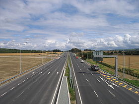
, the highest category of road is a motorway, indicated by the prefix M followed by one or two digits. The motorway network has been expanded extensively since the 1990s, through construction of new motorways and redesignation of existing motorway-standard dual-carriageway sections of National Primary routes.
The first motorway section in the state was the M7 Naas
by-pass, which opened in 1983. As of 2009, all motorways in Ireland are part of, or form, national primary road
s. At the end of 2004 there were 192 km (119.3 mi) of motorway in the Republic and 286 km (177.7 mi) of dual-carriageway. This was extended, by the end of 2005, to 247 km (153.5 mi) of motorway and 297 km (184.5 mi) of dual-carriageway. By the end of December 2009 there were 667 km (414.5 mi) of motorway in Ireland, with 385 kilometres (239.2 mi) under construction.
As of 2011, the following motorway routes are in operation:
In June 2007, it was announced that around 800 kilometres of 'new' motorway would be created; however, much of this resulted from the re-classification of most of the country's high-quality dual carriageway
s to motorway regulations rather than the construction of purpose-built motorways. This has affected most of the major inter-urban routes between Dublin and various towns and cities and some of the Atlantic Corridor
along the Western seaboard. In December 2007, it was announced that a planned high quality dual carriageway scheme between Galway
and Tuam
would be built as a motorway, the first such new motorway project to be announced since the early 2000s.
Northern Ireland route sections (which are classified separately according to NI schemes) are in some cases included in a theoretical complete cross-border route – for example the N3 route, which re-enters the Republic. These are listed here in brackets for completeness (and are present on southern road signage).
 This list ignores the sections of route reclassified as motorway (see previous section).
 National secondary roads are also indicated with a "N" prefix. Routes N51
and higher (currently to N87
) are national secondary routes.
There are 2683.974 km of national secondary roads in Ireland, making up slightly less than 50% of the entire national route (national primary and national secondary) network. National secondary routes are generally more poorly maintained than primary routes (although their quality can vary widely), but often carry more traffic than regional road
s. Almost the entire network of national secondary roads is single carriageway
, although there are some short sections of dual carriageway
on the Tallaght
bypass section of the N81, on the N52
at Dundalk
, on the N85
at Ennis
, on the N62
at Athlone and on the N71
between Cork and Bandon
. Typically, national secondary roads are of a similar standard or higher than regional roads although some are of lower quality than the better sections of regional roads. Many of them have been resurfaced with higher quality pavements in recent years with relatively smooth surfaces and good road markings and signposting. However, road widths and alignments are often inadequate, with many narrow and winding sections.
National secondary roads generally do not bypass towns on their routes although there are a number of exceptions: the N52 bypasses Nenagh
, Mullingar
and the centre of Dundalk (as a relief road) with a further N52 bypass of Tullamore
planned, the N55
(along with the N3) bypasses Cavan
, the N56
forms part of the Donegal
bypass, the N61
and the N63
bypass Roscommon
, the N71 bypasses Halfway
and Skibbereen
, the N74
bypasses Cashel
, the N76
bypasses Callan, the N77
forms the northern part of the Kilkenny
ring road, the N80
bypasses Carlow
and the N85 bypasses Ennis
. When the Fermoy
(Moorepark) to Kilbehenny section of the M8
was completed, the former N8 bypass of Mitchelstown
was re-classified as the N73
.
Examples of national secondary roads are:
and the R710 Waterford Outer Ring Road
are dual-carriageway in whole or part. Most regional roads are however single carriageway
roads, and many are rather narrow country roads.
Regional roads are subject to a general speed limit
of 80 km/h (imperial equivalent: 50 mph) or 50 km/h (imperial equivalent: 31.25 mph) in built-up areas.
While funding for national primary roads is administered centrally by the National Roads Authority
(NRA), regional and local roads are less well funded (although funding has increased in the 2000s). Local councils are responsible for these roads, as opposed to the NRA.
 All public roads which are not motorways, national roads or regional roads are local roads
: "a public road, other than a national road or a regional road, shall be a local road".
Local roads vary greatly in quality, from wide urban streets to very narrow, rural lanes, known as boreen
s in Ireland. There are three types of Local Road: Local Primary (local roads wider than 4 metres), Local Secondary (local roads narrower than 4 metres) and Local Tertiary (cul-de-sacs and other minor roads).
Local roads are subject to a general speed limit
of 80 km/h (imperial equivalent: 50 mph) or 50 km/h (imperial equivalent: 31.25 mph) in built-up areas.
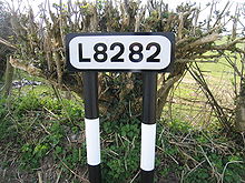
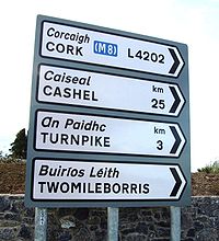
Local roads are not generally referred to by number, but are registered with a four- or five-digit "L" number, taking the form Lxxxx. It used to be rare to see these numbers on signposts (and these numbers do not appear on Ordnance Survey maps), but in 2006 the Department of the Environment, Heritage and Local Government began a programme of new signage for regional roads that incorporates local
road numbers on directional signage (see thumbnails).
 The Republic of Ireland had a different road numbering system prior to the introduction of the National Route numbering system.
Major roads were marked with "T" for Trunk Road
, less important roads were marked with "L" for Link Road.
The first nine Trunk Roads (T1, T2, T3, T4, T4a, T5, T6, T7, T8) radiated out from Dublin (with the T8 branching off the T7 at Enniscorthy) and followed an anti-clockwise pattern. This pattern was similar to the existing anti-clockwise pattern which the routes radiating out of Dublin follow.
Unlike the present system, where each road (whether N- or R-) has a unique number, under the Trunk/Link system, the L-roads were numbered separately beginning with L1. These L (for Link Road) classifications are not related to the current Lxxxx numbers for Local Roads. Confusingly, some old road signs
still show the former (now obsolete) road numbers.
Trunk Roads were broadly equivalent to the present National Roads, and Link Roads to the present Regional Roads. Most of the National Primary and National Secondary routes had been Trunk Roads and generally they followed the routes of these Trunk roads, albeit with a different numbering system. However, some National Primary and Secondary roads also incorporated Link Roads and unclassified roads into their routes. Furthermore, many Trunk Roads were downgraded to Regional roads, effectively 'de-trunked'. Some newer National Primary routes were built as new roads in the 1990s and therefore did not incorporate former Trunk, Link or unclassified roads into their routes.
. Whereas the roads in Great Britain are numbered according to a zonal system
, there is no available explanation for the allocation of road numbers in Northern Ireland, though their numbering is separate from the system in England
, Scotland
and Wales
.
include sections in Ireland:
Ireland
Ireland is an island to the northwest of continental Europe. It is the third-largest island in Europe and the twentieth-largest island on Earth...
, comprising Northern Ireland
Northern Ireland
Northern Ireland is one of the four countries of the United Kingdom. Situated in the north-east of the island of Ireland, it shares a border with the Republic of Ireland to the south and west...
and the Republic of Ireland
Republic of Ireland
Ireland , described as the Republic of Ireland , is a sovereign state in Europe occupying approximately five-sixths of the island of the same name. Its capital is Dublin. Ireland, which had a population of 4.58 million in 2011, is a constitutional republic governed as a parliamentary democracy,...
, has an extensive network of tens of thousands of kilometres of public roads, usually surfaced. These roads have been developed and modernised over centuries, from trackways suitable only for walkers and horses, to surfaced roads including modern motorways. Northern Ireland has had motorways since 1962, and has a well-developed network of primary, secondary and local routes. Historically, the road network in the Republic of Ireland was less well developed and maintained. However, with the advent of the Celtic Tiger
Celtic Tiger
Celtic Tiger is a term used to describe the economy of Ireland during a period of rapid economic growth between 1995 and 2007. The expansion underwent a dramatic reversal from 2008, with GDP contracting by 14% and unemployment levels rising to 14% by 2010...
and significant European Union
European Union
The European Union is an economic and political union of 27 independent member states which are located primarily in Europe. The EU traces its origins from the European Coal and Steel Community and the European Economic Community , formed by six countries in 1958...
funding, most national roads in the Republic
Republic of Ireland
Ireland , described as the Republic of Ireland , is a sovereign state in Europe occupying approximately five-sixths of the island of the same name. Its capital is Dublin. Ireland, which had a population of 4.58 million in 2011, is a constitutional republic governed as a parliamentary democracy,...
continue to be upgraded. In the 1990s the Republic went from having only a few short sections of motorway to constructing motorways, dual-carriageways
Dual carriageway
A dual carriageway is a class of highway with two carriageways for traffic travelling in opposite directions separated by a central reservation...
and other improvements on most major routes as part of a National Development Plan
National Development Plan
National Development Plan is the title given by the Irish Government to a scheme of organised large-scale expenditure on national infrastructure. The period covered by the seven year plan runs from 2000 to 2006. A second National Development Plan is currently in progress and is due to run until...
. Road construction in Northern Ireland has proceeded at a slower pace in recent years, although a number of important bypasses and upgrades to dual carriageway have recently been completed or are about to begin.
The major differences between roads in Northern Ireland and the Republic of Ireland are in road quality and route classification, signposts
Traffic sign
Traffic signs or road signs are signs erected at the side of roads to provide information to road users. With traffic volumes increasing over the last eight decades, many countries have adopted pictorial signs or otherwise simplified and standardized their signs to facilitate international travel...
and speed limits.
Roads in Northern Ireland are classified as either motorways (shown by the letter M followed by a route number, e.g. M1), A-roads (shown by the letter A followed by a route number, e.g. A6), B-roads (shown by the letter B followed by a route number, e.g. B135) and other roads. There are two types of A-roads: primary and non-primary. Roads in the Republic are classified as either motorways (shown by the letter M followed by a route number, e.g. M7), National roads (shown by the letter N followed by a route number, e.g. N25), Regional road
Regional road
A regional road in Ireland is a class of road not forming a major route , but nevertheless forming a link in the national route network. There are over 11,600 kilometres of regional roads. Regional roads are numbered with three digit route numbers, prefixed by "R" A regional road in Ireland is a...
s (shown by the letter R followed by a route number, e.g. R611) and Local roads
Local Roads in Ireland
A Local Road in Ireland is a class of public road not classified as a National road or as a Regional road but nevertheless forming a link in the national network of roads...
(shown by the letter L followed by a route number, e.g. L4202). There are two types of National roads: National Primary routes
National primary road
A national primary road is a road classification in the Republic of Ireland. National primary roads form the major routes between the major urban centres. There are over 2,700km of national primary roads. This category of road has the prefix "N" followed by one or two digits...
and National Secondary routes
National secondary road
A national secondary road is a category of road in Ireland. These roads form an important part of the national route network, but are secondary to the main arterial routes which are classified as national primary roads. National secondary roads are designated with route numbers higher than those...
.
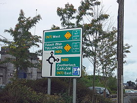
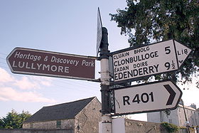
Distance signposts in Northern Ireland show distances in miles, while all signposts placed in the Republic since the 1990s use kilometres. The Republic's road signs are bilingual, using both official languages, Irish
Irish language
Irish , also known as Irish Gaelic, is a Goidelic language of the Indo-European language family, originating in Ireland and historically spoken by the Irish people. Irish is now spoken as a first language by a minority of Irish people, as well as being a second language of a larger proportion of...
and English
English language
English is a West Germanic language that arose in the Anglo-Saxon kingdoms of England and spread into what was to become south-east Scotland under the influence of the Anglian medieval kingdom of Northumbria...
. The Irish names are written in lower case italic script. Signs in Northern Ireland are in English only. Warning signs in the Republic have a yellow background and are diamond-shaped, those in Northern Ireland are triangle-shaped and have a white background with a red border.
Speed limits in Northern Ireland are specified in miles per hour. Those in the Republic use kilometres per hour
Road speed limits in the Republic of Ireland
Road speed limits in the Republic of Ireland apply on all public roads in the country. These are signposted and legislated for in kilometres per hour. Speed limits are demarcated by regulatory road signs . These consist of white circular signs with a red outline. Speed limits are marked in black...
(km/h), a change introduced on 20 January 2005. This involved the provision of 58,000 new metric speed limit signs, replacing and supplementing 35,000 imperial signs.
History
There have been routes and trackways in Ireland connecting settlements and facilitating trade since ancient times. Ireland was never part of the Roman EmpireRoman Empire
The Roman Empire was the post-Republican period of the ancient Roman civilization, characterised by an autocratic form of government and large territorial holdings in Europe and around the Mediterranean....
and, therefore, Roman roads were not built in Ireland. However, an Iron Age
Iron Age
The Iron Age is the archaeological period generally occurring after the Bronze Age, marked by the prevalent use of iron. The early period of the age is characterized by the widespread use of iron or steel. The adoption of such material coincided with other changes in society, including differing...
road with a stone surface has been excavated in Munster
Munster
Munster is one of the Provinces of Ireland situated in the south of Ireland. In Ancient Ireland, it was one of the fifths ruled by a "king of over-kings" . Following the Norman invasion of Ireland, the ancient kingdoms were shired into a number of counties for administrative and judicial purposes...
and togher roads, a type of causeway
Causeway
In modern usage, a causeway is a road or railway elevated, usually across a broad body of water or wetland.- Etymology :When first used, the word appeared in a form such as “causey way” making clear its derivation from the earlier form “causey”. This word seems to have come from the same source by...
built through bogs, were found in many areas of the country.
According to an entry in the Annals of the Four Masters
Annals of the Four Masters
The Annals of the Kingdom of Ireland or the Annals of the Four Masters are a chronicle of medieval Irish history...
for AD 123, there were five principal highways leading to Tara
Hill of Tara
The Hill of Tara , located near the River Boyne, is an archaeological complex that runs between Navan and Dunshaughlin in County Meath, Leinster, Ireland...
in Early Medieval Ireland.
Early medieval law-tracts set out five types of road including the highway (slighe), the '[regional] main road' (ród or rout), the 'connecting road' (lámraite), the 'side road' (tógraite) which could be tolled, and the 'cow road' (bóthar). Bóthar is the most common term for 'road' in modern Irish
Irish language
Irish , also known as Irish Gaelic, is a Goidelic language of the Indo-European language family, originating in Ireland and historically spoken by the Irish people. Irish is now spoken as a first language by a minority of Irish people, as well as being a second language of a larger proportion of...
: its diminutive
Diminutive
In language structure, a diminutive, or diminutive form , is a formation of a word used to convey a slight degree of the root meaning, smallness of the object or quality named, encapsulation, intimacy, or endearment...
form, bóithrín, (or boreen
Boreen
Boreen or bohereen is an anglicised, Hiberno-English term normally meaning a narrow, frequently unpaved, rural road in Ireland. "Boreen" also appears sometimes in names of minor urban roads such as Saint Mobhi Bóithrín , commonly known as Mobhi Boreen in Glasnevin, Dublin....
in English
English language
English is a West Germanic language that arose in the Anglo-Saxon kingdoms of England and spread into what was to become south-east Scotland under the influence of the Anglian medieval kingdom of Northumbria...
) is used as a term for very narrow, rural roads.
The development of roads in Ireland seemed to have stagnated until the eighteenth- and early nineteenth-centuries. However, in the 18th century, a network of turnpike roads (charging tolls) was built: "a turnpike was a primitive form of turnstile - a gate across the road, opened on payment of a toll. The average length of a turnpike road was 30 miles". Routes to and from Dublin were developed initially and the network spread throughout the country. Turnpikes operated between 1729 and 1858 when the extensive railway network made them increasingly unpopular.
Specialist routes to facilitate the butter
Butter
Butter is a dairy product made by churning fresh or fermented cream or milk. It is generally used as a spread and a condiment, as well as in cooking applications, such as baking, sauce making, and pan frying...
trade, which centered on Cork
Cork (city)
Cork is the second largest city in the Republic of Ireland and the island of Ireland's third most populous city. It is the principal city and administrative centre of County Cork and the largest city in the province of Munster. Cork has a population of 119,418, while the addition of the suburban...
, were built in Munster
Munster
Munster is one of the Provinces of Ireland situated in the south of Ireland. In Ancient Ireland, it was one of the fifths ruled by a "king of over-kings" . Following the Norman invasion of Ireland, the ancient kingdoms were shired into a number of counties for administrative and judicial purposes...
. The first butter road was commissioned in 1748 and was built by John Murphy of Castleisland
Castleisland
Castleisland is a town and commercial centre in County Kerry in south west Ireland. The town is renowned for the width of its main street. Castleisland has a population of 2,170....
in Co. Kerry. In other areas, notably in Co. Wicklow, military roads were built to help secure British military control over remote areas. The Military Road through Co. Wicklow was begun in 1800 and completed in 1809. The R115
R115 road
The R115 road is a regional road in counties Dublin and Wicklow in Ireland. It follows the Military Road for its entire length. The R115 is long; the full length of the Military Road is...
is part of the Military Road for its entire length.
Railways became the dominant form of land transport from the mid-19th century. This situation persisted until the first half of the 20th century when motorised road transport (cars, buses and trucks) gradually began to take over from railways as the most important form of land transport.
Pre-independence legislation (the Ministry of Transport Act, 1919) laid the foundation for the regulation of the modern system of public roads in Ireland. The Act gave the Minister for Local Government the power to classify roads: Trunk Road Funds were used to enable local councils to improve major roads and road surfacing was gradually undertaken throughout the 1920s, 1930s and beyond.
By the 1950s an established system of road classification and numbering with Trunk Roads and Link Roads
Trunk Roads in Ireland
Ireland has an extensive network of public roads which connect all parts of the country with each other. Roads in Ireland are currently classified as motorways, National Primary routes, National secondary routes, Regional roads and Local roads. The introduction of this classification system began...
had long been developed. The present system of road classification and numbering began in 1977 when twenty-five National Primary roads
National primary road
A national primary road is a road classification in the Republic of Ireland. National primary roads form the major routes between the major urban centres. There are over 2,700km of national primary roads. This category of road has the prefix "N" followed by one or two digits...
and thirty-three National Secondary roads
National secondary road
A national secondary road is a category of road in Ireland. These roads form an important part of the national route network, but are secondary to the main arterial routes which are classified as national primary roads. National secondary roads are designated with route numbers higher than those...
were designated.
Regional road
Regional road
A regional road in Ireland is a class of road not forming a major route , but nevertheless forming a link in the national route network. There are over 11,600 kilometres of regional roads. Regional roads are numbered with three digit route numbers, prefixed by "R" A regional road in Ireland is a...
s were first formally designated in 1994, although Regional road route-numbers began appearing on signposts in the 1980s. The Roads Act 1993 also classified all public roads which are not national or regional roads as local roads
Local Roads in Ireland
A Local Road in Ireland is a class of public road not classified as a National road or as a Regional road but nevertheless forming a link in the national network of roads...
.
Roads in the Republic of Ireland
As of 31 December 2007, there was a total of 5,427.58 km of national roads: 2,743.606 km of national primary routes (including motorways) and 2,683.974 km of national secondary routes. In addition to national roads, the Republic also has an extensive network of other public roads: there are 11,630 kilometres of regional roads and 78,972 kilometres of local roads.
The Republic's major road network is focused on Dublin. Motorways were extended from Dublin to other major cities as part of the Transport 21
Transport 21
Transport 21 is an Irish infrastructure plan, announced in November 2005. It aims to greatly expand Ireland's transport network. A cost estimate of €34 billion was attached to the plan at the time....
programme which aimed to have a world-class motorway network in place by the end of 2010. By the end of 2010, Ireland's main cities (Cork
Cork (city)
Cork is the second largest city in the Republic of Ireland and the island of Ireland's third most populous city. It is the principal city and administrative centre of County Cork and the largest city in the province of Munster. Cork has a population of 119,418, while the addition of the suburban...
, Limerick
Limerick
Limerick is the third largest city in the Republic of Ireland, and the principal city of County Limerick and Ireland's Mid-West Region. It is the fifth most populous city in all of Ireland. When taking the extra-municipal suburbs into account, Limerick is the third largest conurbation in the...
, Galway
Galway
Galway or City of Galway is a city in County Galway, Republic of Ireland. It is the sixth largest and the fastest-growing city in Ireland. It is also the third largest city within the Republic and the only city in the Province of Connacht. Located on the west coast of Ireland, it sits on the...
, and Waterford
Waterford
Waterford is a city in the South-East Region of Ireland. It is the oldest city in the country and fifth largest by population. Waterford City Council is the local government authority for the city and its immediate hinterland...
, Belfast
Belfast
Belfast is the capital of and largest city in Northern Ireland. By population, it is the 14th biggest city in the United Kingdom and second biggest on the island of Ireland . It is the seat of the devolved government and legislative Northern Ireland Assembly...
) excluding Derry
Derry
Derry or Londonderry is the second-biggest city in Northern Ireland and the fourth-biggest city on the island of Ireland. The name Derry is an anglicisation of the Irish name Doire or Doire Cholmcille meaning "oak-wood of Colmcille"...
were connected to Dublin with motorways or with near-motorway standard roads. Dublin has been the focus of some other major projects, such as the East-Link
East-Link (Dublin)
The East-Link is a toll bridge in Dublin, Ireland, on the River Liffey, owned by Dublin City Council and operated by NTR plc. The lifting bridge, which links North Wall to Ringsend, is the last bridge on the Liffey, which opens out into Dublin Port and then Dublin Bay just beyond...
and West-Link
West-Link
The West-Link is a toll bridge on the M50 motorway to the west of Dublin, Ireland, operated by BetEire Flow Limited for the National Roads Authority.- Structure :...
toll-bridges, as well as the Dublin Port Tunnel
Dublin Port Tunnel
The Dublin Port Tunnel is a road traffic tunnel in Dublin, Ireland, that forms part of the M50 motorway....
. Major by-pass projects are underway at other cities and towns; most of these are under construction as of 2009. The Jack Lynch Tunnel
Jack Lynch Tunnel
The Jack Lynch Tunnel is an immersed tube tunnel and an integral part of the N25 southern ring road of Cork in Ireland. It is named after former Taoiseach, Jack Lynch, a native of Cork....
under the River Lee
River Lee (Ireland)
The Lee is a river in Ireland. It rises in the Shehy Mountains on the western border of County Cork and flows eastwards through Cork City, where it splits in two for a short distance, creating an island on which Cork's city centre is built, and empties into the Celtic Sea at Cork Harbour on the...
in Cork
Cork (city)
Cork is the second largest city in the Republic of Ireland and the island of Ireland's third most populous city. It is the principal city and administrative centre of County Cork and the largest city in the province of Munster. Cork has a population of 119,418, while the addition of the suburban...
was a major project outside Dublin, and a fourth crossing at Limerick
Limerick
Limerick is the third largest city in the Republic of Ireland, and the principal city of County Limerick and Ireland's Mid-West Region. It is the fifth most populous city in all of Ireland. When taking the extra-municipal suburbs into account, Limerick is the third largest conurbation in the...
under the River Shannon
River Shannon
The River Shannon is the longest river in Ireland at . It divides the west of Ireland from the east and south . County Clare, being west of the Shannon but part of the province of Munster, is the major exception...
(known as the Limerick Tunnel
Limerick Tunnel
The Limerick Tunnel is a 675m long, twin-bore road tunnel underneath the River Shannon on the outskirts of Limerick City. The tunnel forms part of the N18 Limerick Southern Ring Road. The tunnel is tolled....
) opened in 2010.
The different classes of roads in Ireland are allocated blocks of numbers so that no number is used more than once.(not all road numbers are currently in use):
- National Primary Roads are numbered from N1 to N50 (motorway sections are signed with M prefix instead of N ).
- National Secondary Roads are numbered from N51 to N99.
- Regional Roads are numbered from R100 to R999.
- Local Primary Roads are numbered from L1000 to L4999.
- Local Secondary Roads are numbered from L5000 to L8999.
- Local Tertiary Roads are numbered from L10001 to L89999 with the first 4 digits representing the Local Primary or Secondary road it is off. Local Tertiary roads which are unrelated to a Local Primary or Secondary road are given numbers from L90000 up.
Motorways
In the Republic of IrelandRepublic of Ireland
Ireland , described as the Republic of Ireland , is a sovereign state in Europe occupying approximately five-sixths of the island of the same name. Its capital is Dublin. Ireland, which had a population of 4.58 million in 2011, is a constitutional republic governed as a parliamentary democracy,...
, the highest category of road is a motorway, indicated by the prefix M followed by one or two digits. The motorway network has been expanded extensively since the 1990s, through construction of new motorways and redesignation of existing motorway-standard dual-carriageway sections of National Primary routes.
The first motorway section in the state was the M7 Naas
Naas
Naas is the county town of County Kildare in Ireland. With a population of just over twenty thousand, it is also the largest town in the county. Naas is a major commuter suburb, with many people residing there and working in Dublin...
by-pass, which opened in 1983. As of 2009, all motorways in Ireland are part of, or form, national primary road
National primary road
A national primary road is a road classification in the Republic of Ireland. National primary roads form the major routes between the major urban centres. There are over 2,700km of national primary roads. This category of road has the prefix "N" followed by one or two digits...
s. At the end of 2004 there were 192 km (119.3 mi) of motorway in the Republic and 286 km (177.7 mi) of dual-carriageway. This was extended, by the end of 2005, to 247 km (153.5 mi) of motorway and 297 km (184.5 mi) of dual-carriageway. By the end of December 2009 there were 667 km (414.5 mi) of motorway in Ireland, with 385 kilometres (239.2 mi) under construction.
As of 2011, the following motorway routes are in operation:
- M1, part of the DublinBelfast route: from M50 J3 at Dublin Airport to Thistle Cross (just north of Drogheda) where it reverts to the N1 dual carriageway up to the border with Northern Ireland (where it continues without interruption as the A1A1 road (Northern Ireland)The A1 is a major route in Northern Ireland. It runs from Belfast via Lisburn and Banbridge to the border with the Republic of Ireland south of Newry, from where the road continues to Dublin, becoming the N1 road and M1 motorway...
to Belfast). - M2, part of the DublinDerry route: from M50 J5 to just north of Ashbourne, Co Meath, where it reverts to the N2.
- M3, part of the DublinCavan/Enniskillen route: from Bracetown (on N3 from M50 J6) to Kells bypass.
- M4, part of the DublinSligo route: from Lucan (on N4 from M50 J7) to Kinnegad at which point it reverts to dual carriageway to (bypass) Mullingar.
- M6, part of the DublinGalway route: leaves M4 at J11 near Kinnegad, ending at the N17 crossing where it reverts to the N6 dual carriageway around Galway. The section around Athlone reverts to N6 status as it is an all-traffic dual carriageway. This was the first city-to-city motorway link in Ireland. Opened Jan 2010
- M7, part of the DublinLimerick route: begins at the Naas bypass at the end of the N7 Naas Road dual carriageway from M50 J9. Reverts to N7 at Nenagh.
- M8, part of the DublinCork route: branches off the M7 at an unnumbered junction and heads for Cork, and completes what is effectively a city-to-city motorway. The moterway reverts to N8 status at Priory Court, just north of Cork.
- M9, part of the DublinWaterford route: branches off the M7 at junction 11 and heads for Kilkenny at which point it continues to Waterford at the N9.
- M11, part of the DublinWexford route: the southern tip of the M50 merges into the M11 at M50 J17/M11 J4. The M11 reverts to N11 status on the west side of Bray
In June 2007, it was announced that around 800 kilometres of 'new' motorway would be created; however, much of this resulted from the re-classification of most of the country's high-quality dual carriageway
High-quality dual carriageway
A High-quality dual carriageway is a category of road in the Republic of Ireland. It is an all-purpose dual carriageway road type built to near motorway standards, but without motorway classification or motorway restrictions. High-quality dual carriageways have full grade-separated access and do...
s to motorway regulations rather than the construction of purpose-built motorways. This has affected most of the major inter-urban routes between Dublin and various towns and cities and some of the Atlantic Corridor
Atlantic Corridor
The Atlantic Corridor is a road project in Ireland that eventually will link Waterford in the South-East to Letterkenny in the North-West by high-quality dual carriageway or motorway. A major infrastructure project, the scheme was announced as part of the Transport 21 project launch in 2005, and is...
along the Western seaboard. In December 2007, it was announced that a planned high quality dual carriageway scheme between Galway
Galway
Galway or City of Galway is a city in County Galway, Republic of Ireland. It is the sixth largest and the fastest-growing city in Ireland. It is also the third largest city within the Republic and the only city in the Province of Connacht. Located on the west coast of Ireland, it sits on the...
and Tuam
Tuam
Tuam is a town in County Galway, Ireland. The name is pronounced choo-um . It is situated west of the midlands of Ireland, and north of Galway city.-History:...
would be built as a motorway, the first such new motorway project to be announced since the early 2000s.
- Another new motorway, the M20, is being planned as the main route between CorkCork (city)Cork is the second largest city in the Republic of Ireland and the island of Ireland's third most populous city. It is the principal city and administrative centre of County Cork and the largest city in the province of Munster. Cork has a population of 119,418, while the addition of the suburban...
and LimerickLimerickLimerick is the third largest city in the Republic of Ireland, and the principal city of County Limerick and Ireland's Mid-West Region. It is the fifth most populous city in all of Ireland. When taking the extra-municipal suburbs into account, Limerick is the third largest conurbation in the...
. - By 2015, the NRA planned that there would be approximately 1090 km of motorway in Ireland, comprising the M50M50 motorway (Ireland)The M50 motorway is a motorway in Ireland running in a C-shaped ring around the north-eastern, northern, western and southern sides of the capital city, Dublin. The northern end of the route is located at the entrance to the Dublin Port Tunnel. Anti-clockwise it heads northwest through the tunnel...
(49 km), M20 (90 km approx), M18 (70 km approx), M17 (25.5 km), M11 (62 km), M9M9 motorway (Ireland)The M9 motorway is a motorway in Ireland linking the M7 at Kilcullen to Waterford. Opened in sections between 1994 and 2010, the final section opened on 9 September 2010....
(116.5 km), M8M8 motorway (Ireland)The M8 motorway is an inter-urban motorway in Ireland, which forms part of the road from the capital - Dublin - to Cork city. The 149 km motorway commences in the townland of Aghaboe, County Laois and runs through the counties of Kilkenny, North Tipperary, South Tipperary and Limerick,...
(143 km), M7 (185 km), M6M6 motorway (Ireland)The M6 motorway is a motorway in Ireland, which runs from Dublin to Galway. The M6 extends from its junction with the M4 at Kinnegad all the way west to the outskirts of Galway City, but the Athlone bypass and the approach to Galway city - while of dual carriageway standard - have not been...
(144 km), M4 (62 km), M3 (57 km), M2 (13 km), and M1 (83 km). However the Irish financial crisis has brought this target into question. - On 30 September 2008 (see below), it was announced that the proposed 26.6 km GortGortGort is a town in south County Galway in the west of Ireland. An Gort is the official Irish name for the town, as defined by the Placenames Commission. In spoken Irish, however, the town is known by its traditional name Gort Inse Guaire. It lies just north of the border with County Clare on the...
to OranmoreOranmoreOranmore is a village in County Galway on the outskirts of Galway city in Ireland. With its major housing developments, Oranmore is rapidly becoming a part of Galway's commuter or suburban belt...
scheme was to be included in the second tranche of motorway re-designations as it will link into the proposed M17.
National primary roads
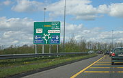
This category of road has the prefix "N" followed by one or two digits. The most important routes are numbered N1-N11 (radiate anti-clockwise from Dublin), with those in the range N12-N33 being cross-country roads. National secondary roads (see next section) are numbered under the same scheme with higher numbers. On road signage, destinations served but not on the route in question are listed in brackets, with the connecting route also listed (see thumbnail).Northern Ireland route sections (which are classified separately according to NI schemes) are in some cases included in a theoretical complete cross-border route – for example the N3 route, which re-enters the Republic. These are listed here in brackets for completeness (and are present on southern road signage).
| Name | Description |
|---|---|
| N1 | Dublin – Border (North of Dundalk) – (A1 Newry Newry Newry is a city in Northern Ireland. The River Clanrye, which runs through the city, formed the historic border between County Armagh and County Down. It is from Belfast and from Dublin. Newry had a population of 27,433 at the 2001 Census, while Newry and Mourne Council Area had a population... – Lisburn Lisburn DemographicsLisburn Urban Area is within Belfast Metropolitan Urban Area and is classified as a Large Town by the . On census day there were 71,465 people living in Lisburn... , M1 M1 motorway (Northern Ireland) The M1 is a motorway in Northern Ireland. It is the longest motorway in Northern Ireland and runs for from Belfast to Dungannon through County Down and County Armagh... (NI) to Belfast Belfast Belfast is the capital of and largest city in Northern Ireland. By population, it is the 14th biggest city in the United Kingdom and second biggest on the island of Ireland . It is the seat of the devolved government and legislative Northern Ireland Assembly... ) |
| N2 | Dublin – Monaghan Monaghan Monaghan is the county town of County Monaghan in Ireland. Its population at the 2006 census stood at 7,811 . The town is located on the main road, the N2 road, from Dublin north to both Derry and Letterkenny.-Toponym:... – (A5 Omagh Omagh Omagh is the county town of County Tyrone, Northern Ireland. It is situated where the rivers Drumragh and Camowen meet to form the Strule. The town, which is the largest in the county, had a population of 19,910 at the 2001 Census. Omagh also contains the headquarters of Omagh District Council and... – Derry Derry Derry or Londonderry is the second-biggest city in Northern Ireland and the fourth-biggest city on the island of Ireland. The name Derry is an anglicisation of the Irish name Doire or Doire Cholmcille meaning "oak-wood of Colmcille"... ) |
| N3 | Dublin – Cavan Cavan Cavan is the county town of County Cavan in the Republic of Ireland. The town lies in the north central part of Ireland, near the border with Northern Ireland... – Ballyshannon Ballyshannon Ballyshannon is a town in County Donegal, Ireland. It is located where the N3 and N15 cross the River Erne, and claims to be the oldest town in Ireland.-Location:... (A509 Teemore Teemore Teemore is a small village and townland in County Fermanagh, Northern Ireland. It is three miles south of Derrylin. In the 2001 Census it had a population of 400.... – Enniskillen Enniskillen Enniskillen is a town in County Fermanagh, Northern Ireland. It is located almost exactly in the centre of the county between the Upper and Lower sections of Lough Erne. It had a population of 13,599 in the 2001 Census... , A46 Enniskillen Enniskillen Enniskillen is a town in County Fermanagh, Northern Ireland. It is located almost exactly in the centre of the county between the Upper and Lower sections of Lough Erne. It had a population of 13,599 in the 2001 Census... – Belleek Belleek Belleek may refer to:* Belleek, County Fermanagh, a village in County Fermanagh, Northern Ireland, famous for its pottery.**Belleek Pottery Ltd, the village's major industry... ) |
| N4 | Dublin – Sligo |
| N5 | (N4 from Dublin) – Longford Longford Longford is the county town of County Longford in Ireland. It has a population of 7,622 according to the 2006 census. Approximately one third of the county's population resides in the town. Longford town is also the biggest town in the county... – Castlebar Castlebar Castlebar is the county town of, and at the centre of, County Mayo in Ireland. It is Mayo's largest town by population. The town's population exploded in the late 1990s, increasing by one-third in just six years, though this massive growth has slowed down greatly in recent years... with planned extension to Westport Westport, County Mayo Westport is a town in County Mayo, Ireland. It is situated on the west coast at the south-east corner of Clew Bay, an inlet of the Atlantic Ocean.... |
| N6 | (N4 from Dublin) – Kinnegad Kinnegad Kinnegad or Kinagad is a town in County Westmeath, Ireland. It is near the border with County Meath, at the junction of the N6 and the N4 - two of Ireland's main east-west roads... – Galway |
| N7 | Dublin – Limerick Limerick Limerick is the third largest city in the Republic of Ireland, and the principal city of County Limerick and Ireland's Mid-West Region. It is the fifth most populous city in all of Ireland. When taking the extra-municipal suburbs into account, Limerick is the third largest conurbation in the... |
| N8 | (N7 from Dublin) – Portlaoise – Cork |
| N9 | (N7 from Dublin) – Kilcullen Kilcullen Kilcullen , formally Kilcullen Bridge, is a small town on the River Liffey in County Kildare, Ireland. Its population of 2,985 makes it the 12th largest settlement in County Kildare and the fastest growing in the county, having doubled in population from 1,483 in the census of 2002... – Carlow Carlow Carlow is the county town of County Carlow in Ireland. It is situated in the south-east of Ireland, 84 km from Dublin. County Carlow is the second smallest county in Ireland by area, however Carlow Town is the 14th largest urban area in Ireland by population according to the 2006 census. The... – Waterford Waterford Waterford is a city in the South-East Region of Ireland. It is the oldest city in the country and fifth largest by population. Waterford City Council is the local government authority for the city and its immediate hinterland... |
| N10 | (N9 from Dublin) – Paulstown Paulstown Paulstown is a small village in County Kilkenny in Ireland.Paulstown is located at the junction of the N9 and N10 National primary roads. It is 21 km south of Carlow and 19 km east of Kilkenny.... – Kilkenny Kilkenny Kilkenny is a city and is the county town of the eponymous County Kilkenny in Ireland. It is situated on both banks of the River Nore in the province of Leinster, in the south-east of Ireland... – Ballyhale Ballyhale Ballyhale is a village in County Kilkenny in Ireland. It is south of the city of Kilkenny, roughly half way between Kilkenny and Waterford. The Parish of Ballyhale is made up of three parts; Knockmoylan and the villages of Ballyhale and Knocktopher.... – (N9 to Waterford) |
| N11 | Dublin – Wexford |
| N12 | Monaghan – (A3 to Belfast) |
| N13 | (N15 from Sligo) – Stranorlar Stranorlar Stranorlar is a small town in the Finn Valley of County Donegal, in Ireland. Stranorlar and Ballybofey form the Twin Towns.-Transport:... – Letterkenny Letterkenny Letterkenny , with a population of 17,568, is the largest town in County Donegal, part of the Province of Ulster in Ireland. The town is located on the River Swilly... – (A2 to Derry Derry Derry or Londonderry is the second-biggest city in Northern Ireland and the fourth-biggest city on the island of Ireland. The name Derry is an anglicisation of the Irish name Doire or Doire Cholmcille meaning "oak-wood of Colmcille"... , A6, M22, M2 to Belfast) |
| N14 | Letterkenny – Lifford Lifford Lifford is the county town of County Donegal, Ireland. It is the administrative capital of the county and the seat of Donegal County Council, although the town of Letterkenny is often mistaken for fulfilling this role... – (A5 to Strabane Strabane Strabane , historically spelt Straban,is a town in west County Tyrone, Northern Ireland. It contains the headquarters of Strabane District Council.... ) |
| N15 | Sligo – Donegal Donegal Donegal or Donegal Town is a town in County Donegal, Ireland. Its name, which was historically written in English as Dunnagall or Dunagall, translates from Irish as "stronghold of the foreigners" .... – Lifford – (B72, A5 to Derry Derry Derry or Londonderry is the second-biggest city in Northern Ireland and the fourth-biggest city on the island of Ireland. The name Derry is an anglicisation of the Irish name Doire or Doire Cholmcille meaning "oak-wood of Colmcille"... ) |
| N16 | Sligo – (A4 to Enniskillen, A4, M1 to Belfast) |
| N17 | Galway – Claremorris Claremorris Claremorris , is a town in County Mayo in the west of Ireland, at the junction of the N17 and the N60 national routes. The population of Claremoris in the 2011 Census was 3,979.... – Collooney Collooney -Transport:Collooney is located just off the N4 and N17 roads, having been bypassed twice, by the N4 in 1998, and the N17 in 1992, and is the meeting point of both roads. The town was a significant railway centre, with no less than three railway stations... – (N4 to Sligo) |
| N18 | (N4, N17 from Sligo) – Claregalway Claregalway Claregalway is a village situated about 10 km from the city of Galway in County Galway, Ireland. Claregalway was founded on the banks of the River Clare, hence the derivation of its name: Baile Chláir na Gaillimhe meaning "town on the Clare, in Galway"... – (N6 from Galway) Oranmore Oranmore Oranmore is a village in County Galway on the outskirts of Galway city in Ireland. With its major housing developments, Oranmore is rapidly becoming a part of Galway's commuter or suburban belt... – Ennis Ennis Ennis is the county town of Clare in Ireland. Situated on the River Fergus, it lies north of Limerick and south of Galway. Its name is a shortening of the original .... – Limerick Limerick Limerick is the third largest city in the Republic of Ireland, and the principal city of County Limerick and Ireland's Mid-West Region. It is the fifth most populous city in all of Ireland. When taking the extra-municipal suburbs into account, Limerick is the third largest conurbation in the... |
| N19 | (N18 from Ennis Ennis Ennis is the county town of Clare in Ireland. Situated on the River Fergus, it lies north of Limerick and south of Galway. Its name is a shortening of the original .... /Limerick) – Shannon Town – Shannon Airport Shannon Airport Shannon Airport, is one of the Republic of Ireland's three primary airports along with Dublin and Cork. In 2010 around 1,750,000 passengers passed through the airport, making it the third busiest airport in the Republic of Ireland after Dublin and Cork, and the fifth busiest airport on the island... |
| N20 | Limerick – Cork |
| N21 | Limerick – Castleisland Castleisland Castleisland is a town and commercial centre in County Kerry in south west Ireland. The town is renowned for the width of its main street. Castleisland has a population of 2,170.... – Tralee |
| N22 | Cork – Killarney Killarney Killarney is a town in County Kerry, southwestern Ireland. The town is located north of the MacGillicuddy Reeks, on the northeastern shore of the Lough Lein/Leane which are part of Killarney National Park. The town and its surrounding region are home to St... – Farranfore Farranfore Farranfore is a village in County Kerry, Ireland. It lies on the N22 road approximately midway between Tralee and Killarney and on the railway line connecting those two towns.... – Tralee |
| N23 | (N21 from Limerick) – Castleisland Castleisland Castleisland is a town and commercial centre in County Kerry in south west Ireland. The town is renowned for the width of its main street. Castleisland has a population of 2,170.... – Farranfore Farranfore Farranfore is a village in County Kerry, Ireland. It lies on the N22 road approximately midway between Tralee and Killarney and on the railway line connecting those two towns.... – (N22 to Killarney) |
| N24 | Limerick – Waterford |
| N25 | Cork – Waterford – Rosslare Europort Rosslare Europort Rosslare Europort is a modern seaport located at Rosslare Harbour in County Wexford, Ireland, near the southeastern-most point of Ireland's coastline, handling passenger and freight ferries to and from Wales and France.... |
| N26 | (N4, N5 from Dublin) – Swinford Swinford Swinford, historically called Swineford , is a town in County Mayo, Ireland. It is surrounded by the settlements of Midfield, Meelick, Culmore, Cloonaghboy, Killasser and other villages. It is on the N5 road, located 18 km from Ireland West Airport Knock... – Ballina Ballina, County Mayo Ballina is a large town in north County Mayo in Ireland. It lies at the mouth of the River Moy near Killala Bay, in the Moy valley and Parish of Kilmoremoy, with the Ox Mountain range to the east and the Nephin Beg mountains to the west... |
| N27 | Cork city centre – Cork Airport |
| N28 | Cork – Ringaskiddy Ringaskiddy Ringaskiddy is a village south of Cork city, in County Cork, Ireland. Located across Cork harbour south from Cóbh, and connected to Cork city by the N28 road the village is now a major ferry port Port of Cork with passenger ferry services to France & the United Kingdom.Ringaskiddy has seen huge... |
| N29 | (Spur off N25 east of Waterford to Belview Port) |
| N30 | (N25 from Cork, Waterford near New Ross New Ross New Ross is a town located in southwest County Wexford, in the southeast of Ireland. In 2006 it had a population of 7,709 people, making it the third largest town in the county after Wexford and Enniscorthy.-History:... ) -– Enniscorthy Enniscorthy Enniscorthy is the second largest town in County Wexford, Ireland. The population of the town and environs is 9538. The Placenames Database of Ireland sheds no light on the origins of the town's name. It may refer either to the "Island of Corthaidh" or the "Island of Rocks". With a history going... – (N11 to Dublin) |
| N31 | (Spur off N11 at Dublin to Dún Laoghaire Dún Laoghaire Dún Laoghaire or Dún Laoire , sometimes anglicised as "Dunleary" , is a suburban seaside town in County Dublin, Ireland, about twelve kilometres south of Dublin city centre. It is the county town of Dun Laoghaire-Rathdown County and a major port of entry from Great Britain... ) |
| N32 | (Continuation of M50 to Malahide Road) |
| N33 | (Spur off M1 to Ardee) |
| (N50) | Dublin ring-road. Only exists as the M50 M50 motorway (Ireland) The M50 motorway is a motorway in Ireland running in a C-shaped ring around the north-eastern, northern, western and southern sides of the capital city, Dublin. The northern end of the route is located at the entrance to the Dublin Port Tunnel. Anti-clockwise it heads northwest through the tunnel... , but route set out in legislation as a primary (N) route. |
National secondary roads
N51 road (Ireland)
The N51 road is a national secondary road in Ireland.West to east, it starts in Delvin, County Westmeath at a junction with the N52. It passes through Athboy, a junction with M3 motorway, Navan and Slane, all in County Meath, before crossing the M1 motorway and terminating near Drogheda in County...
and higher (currently to N87
N87 road (Ireland)
-Route:Belturbet – Ballyconnell – Swanlinbar – -See also:*Roads in Ireland*Motorways in Ireland*National primary road*Regional road-References:* – Department of Transport...
) are national secondary routes.
There are 2683.974 km of national secondary roads in Ireland, making up slightly less than 50% of the entire national route (national primary and national secondary) network. National secondary routes are generally more poorly maintained than primary routes (although their quality can vary widely), but often carry more traffic than regional road
Regional road
A regional road in Ireland is a class of road not forming a major route , but nevertheless forming a link in the national route network. There are over 11,600 kilometres of regional roads. Regional roads are numbered with three digit route numbers, prefixed by "R" A regional road in Ireland is a...
s. Almost the entire network of national secondary roads is single carriageway
Single carriageway
A single carriageway is a road with 1, 2 or more lanes arranged within a single carriageway with no central reservation to separate opposing flows of traffic. Two-lane road or two-lane highway are single carriageway with one lane for each direction...
, although there are some short sections of dual carriageway
Dual carriageway
A dual carriageway is a class of highway with two carriageways for traffic travelling in opposite directions separated by a central reservation...
on the Tallaght
Tallaght
Tallaght is the largest town, and county town, of South Dublin County, Ireland. The village area, dating from at least the 17th century, held one of the earliest settlements known in the southern part of the island, and one of medieval Ireland's more important monastic centres.Up to the 1960s...
bypass section of the N81, on the N52
N52 road (Ireland)
The N52 road is a national secondary road in Ireland. It links the M7 motorway from just south of Nenagh, County Tipperary to the M1 motorway north of Dundalk in County Louth.The road is long.-Quality of Road:...
at Dundalk
Dundalk
Dundalk is the county town of County Louth in Ireland. It is situated where the Castletown River flows into Dundalk Bay. The town is close to the border with Northern Ireland and equi-distant from Dublin and Belfast. The town's name, which was historically written as Dundalgan, has associations...
, on the N85
N85 road (Ireland)
The N85 road is a national secondary road in Ireland connecting Ennis and Ennistymon. The route connects to the M18 Ennis bypass and forms part of the Ennis outer ring road as the "N85 Western Relief Road". From Ennis the route continues in a north - west direction and terminates at the junction...
at Ennis
Ennis
Ennis is the county town of Clare in Ireland. Situated on the River Fergus, it lies north of Limerick and south of Galway. Its name is a shortening of the original ....
, on the N62
N62 road (Ireland)
The N62 road is a national secondary road in Ireland. It links the M6 motorway east of Athlone, County Westmeath with junction 6 of the M8 motorway south-east of Thurles in County Tipperary...
at Athlone and on the N71
N71 road (Ireland)
-Road standard:The road is mostly relatively poor single carriageway, with better sections towards the Cork end of the route. There are wide sections with climbing/passing lanes, including a very rare configuration with a passing lane on both sides, and a dual carriageway section approaching...
between Cork and Bandon
Bandon, County Cork
Bandon is a town in County Cork, Ireland. With a population of 5,822 as of census 2006, Bandon lies on the River Bandon between two hills. The name in Irish means "Bridge of the Bandon", a reference to the origin of the town as a crossing-point on the river. In 2004 Bandon celebrated its...
. Typically, national secondary roads are of a similar standard or higher than regional roads although some are of lower quality than the better sections of regional roads. Many of them have been resurfaced with higher quality pavements in recent years with relatively smooth surfaces and good road markings and signposting. However, road widths and alignments are often inadequate, with many narrow and winding sections.
National secondary roads generally do not bypass towns on their routes although there are a number of exceptions: the N52 bypasses Nenagh
Nenagh
Nenagh is the county town of North Tipperary in Ireland. It is the administrative centre of North Tipperary and in 2011 it had a recorded population of 7,995. It is a civil parish in the historical barony of Ormond Lower...
, Mullingar
Mullingar
Mullingar is the county town of County Westmeath in Ireland. The Counties of Meath and Westmeath Act of 1542, proclaimed Westmeath a county, separating it from Meath. Mullingar became the administrative centre for County Westmeath...
and the centre of Dundalk (as a relief road) with a further N52 bypass of Tullamore
Tullamore
Tullamore is a town in County Offaly, in the midlands of Ireland. It is Offaly's county town and the centre of the district.Tullamore is an important commercial and industrial centre in the region. Major international employers in the town include 'Tyco Healthcare' and 'Boston Scientific'. In...
planned, the N55
N55 road (Ireland)
The N55 road is a national secondary road in Ireland linking Athlone on the River Shannon in the centre of the country to Cavan town.-Route:...
(along with the N3) bypasses Cavan
Cavan
Cavan is the county town of County Cavan in the Republic of Ireland. The town lies in the north central part of Ireland, near the border with Northern Ireland...
, the N56
N56 road (Ireland)
The N56 road is a national secondary road in Ireland that runs from Donegal town to Letterkenny. As originally designated, it included the section of the N13 between Stranorlar and Letterkenny, forming a circular route including parts of the N15....
forms part of the Donegal
Donegal
Donegal or Donegal Town is a town in County Donegal, Ireland. Its name, which was historically written in English as Dunnagall or Dunagall, translates from Irish as "stronghold of the foreigners" ....
bypass, the N61
N61 road (Ireland)
The N61 road is a national secondary road in County Roscommon, Ireland, linking the N4, N5 and N6 national primary roads.-Route:Starting at Athlone , the road goes Northwards to Knockcroghery, Roscommon, Tulsk , and ends just North of Boyle at the N4....
and the N63
N63 road (Ireland)
The N63 road is a national secondary road in Ireland. It links the N17 northeast of Galway, to the N5 national primary road in Longford.En route it passes through Mountbellew, Roscommon Town, crosses the River Shannon at Lanesborough.The road is long....
bypass Roscommon
Roscommon
Roscommon is the county town of County Roscommon in Ireland. Its population at the 2006 census stood at 5,017 . The town is located near the junctions of the N60, N61 and N63 roads.-History:...
, the N71 bypasses Halfway
Halfway, County Cork
Halfway is a village in County Cork, in Ireland. Halfway got its name from being situated approximately half-way between Cork City and Bandon. However, with today's road infrastructure and the expansion of Cork city, Halfway is now actually closer to Cork than it is to Bandon.The village is...
and Skibbereen
Skibbereen
Skibbereen , is a town in County Cork, Ireland. It is the most southerly town in Ireland. It is located on the N71 national secondary road.The name "Skibbereen" means "little boat harbour." The River Ilen which runs through the town reaches the sea at Baltimore.-History:Prior to 1600 most of the...
, the N74
N74 road (Ireland)
The N74 road is a national secondary road in Ireland. It runs for its entire length in County Tipperary, east to west from Cashel to Tipperary town, passing through the villages of Golden, Thomastown and Kilfeakle.The N74 is in length...
bypasses Cashel
Cashel, County Tipperary
Cashel is a town in South Tipperary in Ireland. Its population was 2936 at the 2006 census. The town gives its name to the ecclesiastical province of Cashel. Additionally, the cathedra of the Roman Catholic Archdiocese of Cashel and Emly was originally in the town prior to the English Reformation....
, the N76
N76 road (Ireland)
The N76 road is a national secondary road in Ireland. It links the N10 national primary on the ring road south of Kilkenny, County Kilkenny to the N24 national primary route east of Clonmel in County Tipperary.The N76 is one of the oldest roads in Ireland...
bypasses Callan, the N77
N77 road (Ireland)
The N77 road is a national secondary road in Ireland. It links the N10 national primary on the ring road south of Kilkenny, County Kilkenny to the N8 national primary road at Durrow in County Laois.-Upgrades and Extensions:...
forms the northern part of the Kilkenny
Kilkenny
Kilkenny is a city and is the county town of the eponymous County Kilkenny in Ireland. It is situated on both banks of the River Nore in the province of Leinster, in the south-east of Ireland...
ring road, the N80
N80 road (Ireland)
The N80 road is a national secondary road in Ireland that runs southeastwards from its junction with the N52 and R443 in the town of Tullamore in County Offaly, to the N11 at Ballynahallin, just north of Enniscorthy in County Wexford, a distance of 116 km...
bypasses Carlow
Carlow
Carlow is the county town of County Carlow in Ireland. It is situated in the south-east of Ireland, 84 km from Dublin. County Carlow is the second smallest county in Ireland by area, however Carlow Town is the 14th largest urban area in Ireland by population according to the 2006 census. The...
and the N85 bypasses Ennis
Ennis
Ennis is the county town of Clare in Ireland. Situated on the River Fergus, it lies north of Limerick and south of Galway. Its name is a shortening of the original ....
. When the Fermoy
Fermoy
Fermoy is a town in County Cork, Ireland. It is situated on the River Blackwater in the south of Ireland. Its population is some 5,800 inhabitants, environs included ....
(Moorepark) to Kilbehenny section of the M8
M8 motorway (Ireland)
The M8 motorway is an inter-urban motorway in Ireland, which forms part of the road from the capital - Dublin - to Cork city. The 149 km motorway commences in the townland of Aghaboe, County Laois and runs through the counties of Kilkenny, North Tipperary, South Tipperary and Limerick,...
was completed, the former N8 bypass of Mitchelstown
Mitchelstown
Mitchelstown is a town in County Cork, Ireland with a population of approximately 3300. Mitchelstown is situated in the valley to the south of the Galtee Mountains close to the Mitchelstown Caves and is 28 km from Cahir, 50 km from Cork and 59 km from Limerick...
was re-classified as the N73
N73 road (Ireland)
The N73 road is a national secondary road in Ireland. It is made up entirely of single carriageway with few overtaking opportunities and only a small amount of hard shoulder.-Route:...
.
Examples of national secondary roads are:
- N52N52 road (Ireland)The N52 road is a national secondary road in Ireland. It links the M7 motorway from just south of Nenagh, County Tipperary to the M1 motorway north of Dundalk in County Louth.The road is long.-Quality of Road:...
DundalkDundalkDundalk is the county town of County Louth in Ireland. It is situated where the Castletown River flows into Dundalk Bay. The town is close to the border with Northern Ireland and equi-distant from Dublin and Belfast. The town's name, which was historically written as Dundalgan, has associations...
via MullingarMullingarMullingar is the county town of County Westmeath in Ireland. The Counties of Meath and Westmeath Act of 1542, proclaimed Westmeath a county, separating it from Meath. Mullingar became the administrative centre for County Westmeath...
and BirrBirrBirr is a town in County Offaly, Ireland. Once called Parsonstown, after the Parsons family who were local landowners and hereditary Earls of Rosse. It is also a parish in the Roman Catholic Diocese of Killaloe....
to NenaghNenaghNenagh is the county town of North Tipperary in Ireland. It is the administrative centre of North Tipperary and in 2011 it had a recorded population of 7,995. It is a civil parish in the historical barony of Ormond Lower...
joining M7 to LimerickLimerickLimerick is the third largest city in the Republic of Ireland, and the principal city of County Limerick and Ireland's Mid-West Region. It is the fifth most populous city in all of Ireland. When taking the extra-municipal suburbs into account, Limerick is the third largest conurbation in the... - N59N59 road (Ireland)The N59 road is a national secondary road in Ireland. It commences in County Sligo, south of Sligo Town at the Belladrehid interchange with the N4 north of Ballysadare. The route circles around the west of Ireland, passing west from Sligo into County Mayo and through Ballina. The N59 continues...
GalwayGalwayGalway or City of Galway is a city in County Galway, Republic of Ireland. It is the sixth largest and the fastest-growing city in Ireland. It is also the third largest city within the Republic and the only city in the Province of Connacht. Located on the west coast of Ireland, it sits on the...
– ClifdenClifdenClifden is a town on the coast of County Galway, Ireland and being Connemara's largest town, it is often referred to as "the Capital of Connemara". It is located on the Owenglen River where it flows into Clifden Bay...
– WestportWestport, County MayoWestport is a town in County Mayo, Ireland. It is situated on the west coast at the south-east corner of Clew Bay, an inlet of the Atlantic Ocean....
– Bangor ErrisBangor ErrisBangor Erris is a town in Kiltane parish in Erris, County Mayo, Ireland with a population of 500. It is on the banks of the Owenmore River and is the gateway to the Erris Peninsula linking Belmullet with Ballina and Westport, nestled at the foot of the "Bangor Trail" a 22-mile mountain pass across...
– BallinaBallina, County MayoBallina is a large town in north County Mayo in Ireland. It lies at the mouth of the River Moy near Killala Bay, in the Moy valley and Parish of Kilmoremoy, with the Ox Mountain range to the east and the Nephin Beg mountains to the west...
– BallysadareBallysadareBallysadare is a village about 7 kilometres from Sligo town Centre. Built on the Ballysadare river, the area experienced rapid growth during the 'Celtic Tiger' boom, with many new housing developments, many of which now lie empty, creating phantom estates. The village was once choked with heavy... - N62N62 road (Ireland)The N62 road is a national secondary road in Ireland. It links the M6 motorway east of Athlone, County Westmeath with junction 6 of the M8 motorway south-east of Thurles in County Tipperary...
Athlone – Horse and JockeyHorse and JockeyHorse and Jockey is a village in North Tipperary, Ireland. It lies on the R639 road, where it meets the N62 road to Thurles. It lies just off junction 6 of the M8 motorway, which by-passed the village in December 2008... - N74N74 road (Ireland)The N74 road is a national secondary road in Ireland. It runs for its entire length in County Tipperary, east to west from Cashel to Tipperary town, passing through the villages of Golden, Thomastown and Kilfeakle.The N74 is in length...
CashelCashel, County TipperaryCashel is a town in South Tipperary in Ireland. Its population was 2936 at the 2006 census. The town gives its name to the ecclesiastical province of Cashel. Additionally, the cathedra of the Roman Catholic Archdiocese of Cashel and Emly was originally in the town prior to the English Reformation....
– GoldenGolden, County TipperaryGolden is a village in South Tipperary in Ireland. The village is situated on the River Suir. It is located between the towns of Cashel and Tipperary on the N74 road. In older times the village was known as Goldenbridge...
– Tipperary Town - N81 Dublin – TullowTullowTullow is a town in County Carlow, Ireland. It is located on the River Slaney where the N81 road intersects with the R762.-History:There is a statue of Father John Murphy, one of the leaders of the 1798 Rebellion, who was captured near Tullow and executed in the Market Square on 2 July...
- N86N86 road (Ireland)The N86 road is a national secondary road in County Kerry, Ireland. It runs from Tralee to Dingle and passes though Annascaul and Lispole en route. It is in length. It has, in recent years, seen significant improvements to certain stretches of road....
Tralee – DingleDingleDingle is a town in County Kerry, Ireland. The only town on the Dingle Peninsula, it sits on the Atlantic coast, about 49 kilometres southwest of Tralee and 71 kilometres northwest of Killarney....
via LispoleLispoleLispole is a Gaeltacht village in County Kerry, Ireland. It is situated on the Dingle Peninsula 5 miles east of the town of Dingle and 25 miles west of Tralee on the N86 National Secondary Route.-Transport:...
Regional roads
There are over 11,600 kilometres of regional roads. Regional roads are numbered with three digit route numbers, prefixed by "R" (e.g. R105). Route numbers range from R1xx in the north-east to R7xx in the south-east of the country, with newer regional roads numbered R8xx and R9xx. Some of the more important regional roads such as the R136 Outer Orbital, DublinR136 road
The R136 road is a regional road in Ireland, located in the southwest of Dublin. Named the Outer Ring Road, the route , bypasses west of Clondalkin connecting the N4 to the Tallaght Bypass , crossing the N7...
and the R710 Waterford Outer Ring Road
R710 road
The R710 road is a regional road in Ireland. Located in the south of Ireland at Waterford, it forms the Outer Ring Road around the south of the city...
are dual-carriageway in whole or part. Most regional roads are however single carriageway
Single carriageway
A single carriageway is a road with 1, 2 or more lanes arranged within a single carriageway with no central reservation to separate opposing flows of traffic. Two-lane road or two-lane highway are single carriageway with one lane for each direction...
roads, and many are rather narrow country roads.
Regional roads are subject to a general speed limit
Road speed limits in the Republic of Ireland
Road speed limits in the Republic of Ireland apply on all public roads in the country. These are signposted and legislated for in kilometres per hour. Speed limits are demarcated by regulatory road signs . These consist of white circular signs with a red outline. Speed limits are marked in black...
of 80 km/h (imperial equivalent: 50 mph) or 50 km/h (imperial equivalent: 31.25 mph) in built-up areas.
While funding for national primary roads is administered centrally by the National Roads Authority
National Roads Authority
The National Roads Authority is a state body in the Republic of Ireland, responsible for the national road network. The NRA was established as part of the Roads Act 1993 and commenced operations on 23 December 1993 in accordance with S.I. 407 of 1993.County councils remain responsible for local...
(NRA), regional and local roads are less well funded (although funding has increased in the 2000s). Local councils are responsible for these roads, as opposed to the NRA.
Local Roads
Local Roads in Ireland
A Local Road in Ireland is a class of public road not classified as a National road or as a Regional road but nevertheless forming a link in the national network of roads...
: "a public road, other than a national road or a regional road, shall be a local road".
Local roads vary greatly in quality, from wide urban streets to very narrow, rural lanes, known as boreen
Boreen
Boreen or bohereen is an anglicised, Hiberno-English term normally meaning a narrow, frequently unpaved, rural road in Ireland. "Boreen" also appears sometimes in names of minor urban roads such as Saint Mobhi Bóithrín , commonly known as Mobhi Boreen in Glasnevin, Dublin....
s in Ireland. There are three types of Local Road: Local Primary (local roads wider than 4 metres), Local Secondary (local roads narrower than 4 metres) and Local Tertiary (cul-de-sacs and other minor roads).
Local roads are subject to a general speed limit
Road speed limits in the Republic of Ireland
Road speed limits in the Republic of Ireland apply on all public roads in the country. These are signposted and legislated for in kilometres per hour. Speed limits are demarcated by regulatory road signs . These consist of white circular signs with a red outline. Speed limits are marked in black...
of 80 km/h (imperial equivalent: 50 mph) or 50 km/h (imperial equivalent: 31.25 mph) in built-up areas.
Local roads are not generally referred to by number, but are registered with a four- or five-digit "L" number, taking the form Lxxxx. It used to be rare to see these numbers on signposts (and these numbers do not appear on Ordnance Survey maps), but in 2006 the Department of the Environment, Heritage and Local Government began a programme of new signage for regional roads that incorporates local
road numbers on directional signage (see thumbnails).
Old system
Major roads were marked with "T" for Trunk Road
Trunk road
A trunk road, trunk highway, or strategic road is a major road—usually connecting two or more cities, ports, airports, and other things.—which is the recommended route for long-distance and freight traffic...
, less important roads were marked with "L" for Link Road.
The first nine Trunk Roads (T1, T2, T3, T4, T4a, T5, T6, T7, T8) radiated out from Dublin (with the T8 branching off the T7 at Enniscorthy) and followed an anti-clockwise pattern. This pattern was similar to the existing anti-clockwise pattern which the routes radiating out of Dublin follow.
Unlike the present system, where each road (whether N- or R-) has a unique number, under the Trunk/Link system, the L-roads were numbered separately beginning with L1. These L (for Link Road) classifications are not related to the current Lxxxx numbers for Local Roads. Confusingly, some old road signs
Road signs in the Republic of Ireland
Road signs in Ireland mostly differ from the traffic signs used elsewhere in Europe. Directional signage is similar to that of the United Kingdom, but is bilingual. Distances are in kilometres. Apart from directional signage, the basic prohibitory signs such as "no left turn" and "no right turn"...
still show the former (now obsolete) road numbers.
Trunk Roads were broadly equivalent to the present National Roads, and Link Roads to the present Regional Roads. Most of the National Primary and National Secondary routes had been Trunk Roads and generally they followed the routes of these Trunk roads, albeit with a different numbering system. However, some National Primary and Secondary roads also incorporated Link Roads and unclassified roads into their routes. Furthermore, many Trunk Roads were downgraded to Regional roads, effectively 'de-trunked'. Some newer National Primary routes were built as new roads in the 1990s and therefore did not incorporate former Trunk, Link or unclassified roads into their routes.
Former Major Trunk Roads in Ireland & Current Equivalents
- T1 = Dublin – north of Dundalk (Belfast). Mainly present R132R132 roadThe R132 road is one of Ireland's newest regional roads, having been classified following the opening M1 motorway which by-passes most of the old N1 route.By-passed sections of the old N1 were reclassified R132...
, old N1; largely replaced by M1 - T2 = Dublin – north of Monaghan (Derry). Mainly present N2 road
- T3 = Dublin–Sligo. Mainly present N4 road
- T4 = Dublin–Galway. Mainly present N6 road (& R348).
- T5 = Dublin–Limerick. Mainly present N7 road
- T6 = Dublin–Cork. Including parts of present N9 road, N8 road and N30 road
- T7 = Dublin–Waterford. Mainly present N11 road
- T8 = Enniscorthy–Rosslare. Mainly part of present N11 road and N25 road.
- T11 = Cork–Sligo. Mainly present N20 road, N18 road and N17 road
- T12 = Cork–Wexford. Mainly present N25 road
- T13 = Limerick–Waterford. Mainly present N24 road
- T18 = Sligo – near Strabane (Derry). Mainly present N15 road
- T28 = Limerick–Tralee. Mainly present N21 road
- T29 = Cork–Tralee. Mainly present N22 road
- T35 = Dublin–Cavan–Donegal. Mainly present N3 road
- T77 = Dublin–Ballina. Mainly parts of present N5 road & N26 road
Roads in Northern Ireland
The main roads in Northern Ireland, which connect well with those in the south, are classified "M"/"A"/"B" as in Great BritainGreat Britain
Great Britain or Britain is an island situated to the northwest of Continental Europe. It is the ninth largest island in the world, and the largest European island, as well as the largest of the British Isles...
. Whereas the roads in Great Britain are numbered according to a zonal system
Great Britain road numbering scheme
The Great Britain road numbering scheme is a numbering scheme used to classify and identify all roads in Great Britain. Each road is given a single letter, which represents the road's category, and a subsequent number, with a length of between 1 and 4 digits. Originally introduced to arrange...
, there is no available explanation for the allocation of road numbers in Northern Ireland, though their numbering is separate from the system in England
England
England is a country that is part of the United Kingdom. It shares land borders with Scotland to the north and Wales to the west; the Irish Sea is to the north west, the Celtic Sea to the south west, with the North Sea to the east and the English Channel to the south separating it from continental...
, Scotland
Scotland
Scotland is a country that is part of the United Kingdom. Occupying the northern third of the island of Great Britain, it shares a border with England to the south and is bounded by the North Sea to the east, the Atlantic Ocean to the north and west, and the North Channel and Irish Sea to the...
and Wales
Wales
Wales is a country that is part of the United Kingdom and the island of Great Britain, bordered by England to its east and the Atlantic Ocean and Irish Sea to its west. It has a population of three million, and a total area of 20,779 km²...
.
Euro Routes
The following Euro RoutesInternational E-road network
The international E-road network is a numbering system for roads in Europe developed by the United Nations Economic Commission for Europe . The network is numbered from E 1 up and its roads cross national borders...
include sections in Ireland:
- E01European route E01The European route E 01 is a series of roads in Europe, part of the United Nations International E-road network, running from Larne, Northern Ireland to Seville, Spain. There is a sea crossing between Rosslare Harbour, in Ireland, and Ferrol, but no ferry service...
- LarneLarneLarne is a substantial seaport and industrial market town on the east coast of County Antrim, Northern Ireland with a population of 18,228 people in the 2001 Census. As of 2011, there are about 31,000 residents in the greater Larne area. It has been used as a seaport for over 1,000 years, and is...
- BelfastBelfastBelfast is the capital of and largest city in Northern Ireland. By population, it is the 14th biggest city in the United Kingdom and second biggest on the island of Ireland . It is the seat of the devolved government and legislative Northern Ireland Assembly...
- Dublin - RosslareRosslare EuroportRosslare Europort is a modern seaport located at Rosslare Harbour in County Wexford, Ireland, near the southeastern-most point of Ireland's coastline, handling passenger and freight ferries to and from Wales and France....
- A CoruñaA CoruñaA Coruña or La Coruña is a city and municipality of Galicia, Spain. It is the second-largest city in the autonomous community and seventeenth overall in the country...
- PontevedraPontevedraPontevedra is a city in the north-west of the Iberian Peninsula. It is the capital of both the comarca and province of Pontevedra, in Galicia . It is also the capital of its own municipality which is, in fact, often considered as an extension of the actual city...
- Valença do Minho - Vila Real de Santo António - HuelvaHuelvaHuelva is a city in southwestern Spain, the capital of the province of Huelva in the autonomous region of Andalusia. It is located along the Gulf of Cadiz coast, at the confluence of the Odiel and Tinto rivers. According to the 2010 census, the city has a population of 149,410 inhabitants. The...
- Sevilla - E16European route E16European route E 16 is the designation of a main west-east road through Northern Ireland, Scotland and Norway, from Derry to Oslo, via Glasgow, Edinburgh, previously by ferry to Bergen, Voss, through the Gudvanga Tunnel, Lærdal, through the Lærdal Tunnel, over Filefjell to Fagernes, Hønefoss,...
- DerryDerryDerry or Londonderry is the second-biggest city in Northern Ireland and the fourth-biggest city on the island of Ireland. The name Derry is an anglicisation of the Irish name Doire or Doire Cholmcille meaning "oak-wood of Colmcille"...
- BelfastBelfastBelfast is the capital of and largest city in Northern Ireland. By population, it is the 14th biggest city in the United Kingdom and second biggest on the island of Ireland . It is the seat of the devolved government and legislative Northern Ireland Assembly...
... GlasgowGlasgowGlasgow is the largest city in Scotland and third most populous in the United Kingdom. The city is situated on the River Clyde in the country's west central lowlands...
- EdinburghEdinburghEdinburgh is the capital city of Scotland, the second largest city in Scotland, and the eighth most populous in the United Kingdom. The City of Edinburgh Council governs one of Scotland's 32 local government council areas. The council area includes urban Edinburgh and a rural area...
... Bergen - ArnaArna, NorwayArna is a borough and suburb of Bergen, Norway and a former municipality in Hordaland county.Arna has approximately 12,000 inhabitants. Situated behind mount Ulriken, Arna is geographically close to downtown Bergen, but it takes some time to drive there by road as there is no road tunnel as of yet....
- VossVossis a municipality in Hordaland county, Norway. It is part of the traditional district of Voss. The administrative center of the municipality is the village of Vossevangen....
... LærdalLærdalLærdal is a municipality in the southwestern part of Sogn og Fjordane county, Norway. It is part of the traditional district of Sogn. The administrative center of the municipality is the village of Lærdalsøyri...
- TyinTyinTyin is a lake in the southwest part of the Jotunheimen mountain range in Norway. The lake lies in Vang municipality in Oppland county, although a small portion extends into Årdal municipality in Sogn og Fjordane county. The western border follows, for a large part, the border between Vang and...
- FagernesFagernesis the largest settlement in the valley of Valdres, Norway, with a population of 1,801. Fagernes is the administrative centre of the municipality of Nord-Aurdal.See video from the Fagernes Town : *...
- HønefossHønefossHønefoss is a city in Buskerud county, Norway, and the center of the municipality of Ringerike.In 1852, Hønefoss received town status and was separated from Norderhov. Hønefoss celebrated its 150th year of township in 2002...
- SandvikaSandvikais the administrative centre of the municipality of Bærum in Norway. It was declared a city by the municipal council in Bærum on 4 June 2003.Sandvika is situated approximately west of Oslo. It is the main transportation hub for Western Bærum, and has a combined bus and railway station. Sandvika is...
- OsloOsloOslo is a municipality, as well as the capital and most populous city in Norway. As a municipality , it was established on 1 January 1838. Founded around 1048 by King Harald III of Norway, the city was largely destroyed by fire in 1624. The city was moved under the reign of Denmark–Norway's King... - E18European route E18European route E18 runs from Craigavon in the United Kingdom to Saint Petersburg in Russia, passing through Norway, Sweden, and Finland. It is about 1,890 km in length.-United Kingdom:...
- CraigavonCraigavonCraigavon is a settlement in north County Armagh, Northern Ireland. It was a planned settlement that was begun in 1965 and named after Northern Ireland's first Prime Minister — James Craig, 1st Viscount Craigavon. It was intended to be a linear city incorporating Lurgan and Portadown, but this plan...
- BelfastBelfastBelfast is the capital of and largest city in Northern Ireland. By population, it is the 14th biggest city in the United Kingdom and second biggest on the island of Ireland . It is the seat of the devolved government and legislative Northern Ireland Assembly...
- LarneLarneLarne is a substantial seaport and industrial market town on the east coast of County Antrim, Northern Ireland with a population of 18,228 people in the 2001 Census. As of 2011, there are about 31,000 residents in the greater Larne area. It has been used as a seaport for over 1,000 years, and is...
... StranraerStranraerStranraer is a town in the southwest of Scotland. It lies in the west of Dumfries and Galloway and in the county of Wigtownshire.Stranraer lies on the shores of Loch Ryan on the northern side of the isthmus joining the Rhins of Galloway to the mainland...
- Gretna - Carlisle - NewcastleNewcastle upon TyneNewcastle upon Tyne is a city and metropolitan borough of Tyne and Wear, in North East England. Historically a part of Northumberland, it is situated on the north bank of the River Tyne...
... KristiansandKristiansand-History:As indicated by archeological findings in the city, the Kristiansand area has been settled at least since 400 AD. A royal farm is known to have been situated on Oddernes as early as 800, and the first church was built around 1040...
- ArendalArendalis a town and municipality in the county of Aust-Agder, Norway. Arendal belongs to the traditional region of Sørlandet.The town of Arendal is the administrative center the municipality and also of Aust-Agder county...
- PorsgrunnPorsgrunnis a town and municipality in Telemark county, Norway. It is part of the traditional region of Grenland. The administrative centre of the municipality is the town of Porsgrunn....
- LarvikLarvikis a city and municipality in Vestfold county, Norway. The administrative centre of the municipality is the city of Larvik. Larvik kommune - has about 41 364 inhabitants and covers 530 km2....
- SandefjordSandefjordis a city and municipality in Vestfold county, Norway. The administrative centre of the municipality is the city of Sandefjord. The municipality of Sandefjord was established on 1 January 1838...
- HortenHortenis a town and municipality in Vestfold county, Norway—located along the Oslofjord. The administrative centre of the municipality is the town of Horten. The municipality also includes the villages of Borre, Åsgårdstrand, Skoppum, and Nykirke....
- DrammenDrammenDrammen is a city in Buskerud County, Norway. The port and river city of Drammen is centrally located in the eastern and most populated part of Norway.-Location:...
- OsloOsloOslo is a municipality, as well as the capital and most populous city in Norway. As a municipality , it was established on 1 January 1838. Founded around 1048 by King Harald III of Norway, the city was largely destroyed by fire in 1624. The city was moved under the reign of Denmark–Norway's King...
- AskimAskimis a town and a municipality in Østfold county, Norway. The administrative centre of the municipality is the town of Askim. Askim was established as a municipality on 1 January 1838 ....
- KarlstadKarlstadKarlstad is a city, the seat of Karlstad Municipality, the capital of Värmland County, and the largest city in the province Värmland in Sweden. The city had 61,685 inhabitants in 2010 out of a municipal total that during the first quarter 2010 was 84,885 inhabitants...
- ÖrebroÖrebro-Sites of interest:Örebro's old town Wadköping is located on the banks of Svartån . It contains many 18th and 19th century wooden houses, along with museums and exhibitions....
- VästeråsVästeråsVästerås is a city in central Sweden, located on the shore of Lake Mälaren in the province Västmanland, some 100 km west of Stockholm...
- StockholmStockholmStockholm is the capital and the largest city of Sweden and constitutes the most populated urban area in Scandinavia. Stockholm is the most populous city in Sweden, with a population of 851,155 in the municipality , 1.37 million in the urban area , and around 2.1 million in the metropolitan area...
/KapellskärKapellskärKapellskär is a port about north of Stockholm, in Sweden. It is located by the Baltic Sea, in Norrtälje Municipality, Stockholm County and is served by frequent passenger ferry services to Mariehamn, Åland, Finland, operated by Viking Line, with 3 services per day and direction during peak season...
... MariehamnMariehamnMariehamn is the capital of Åland, an autonomous territory under Finnish sovereignty. Mariehamn is the seat of the Government and Parliament of Åland, and 40% of the population of Åland live in the city...
... TurkuTurkuTurku is a city situated on the southwest coast of Finland at the mouth of the Aura River. It is located in the region of Finland Proper. It is believed that Turku came into existence during the end of the 13th century which makes it the oldest city in Finland...
/NaantaliNaantaliNaantali is a city in south-western Finland, known as one of the most important tourist centres of the country. The municipality has a population of , and is located in the region of Finland Proper, west of Turku....
- HelsinkiHelsinkiHelsinki is the capital and largest city in Finland. It is in the region of Uusimaa, located in southern Finland, on the shore of the Gulf of Finland, an arm of the Baltic Sea. The population of the city of Helsinki is , making it by far the most populous municipality in Finland. Helsinki is...
- KotkaKotkaKotka is a town and municipality of Finland. Its former name is Rochensalm.Kotka is located on the coast of the Gulf of Finland at the mouth of Kymi River and it is part of the Kymenlaakso region in southern Finland. The municipality has a population of and covers an area of of which is water....
- VaalimaaVaalimaaVaalimaa is a border crossing point between Finland and Russia. It is located in the Virolahti municipality. With over 2 million annual crossings, it is the busiest border crossing in the Finnish-Russian border, which is also the border of the European Union and Russia. European route E18 passes...
- VyborgVyborgVyborg is a town in Leningrad Oblast, Russia, situated on the Karelian Isthmus near the head of the Bay of Vyborg, to the northwest of St. Petersburg and south from Russia's border with Finland, where the Saimaa Canal enters the Gulf of Finland...
- Saint PetersburgSaint PetersburgSaint Petersburg is a city and a federal subject of Russia located on the Neva River at the head of the Gulf of Finland on the Baltic Sea... - E20European route E20The European route E 20 is part of the United Nations International E-road network.It runs roughly west-east through Ireland, the United Kingdom, Denmark, Sweden, Estonia and finally Russia. The length is . The road is not continuous, at three points, a sea crossing is required. ...
- Shannon - Limerick - Dublin ... LiverpoolLiverpoolLiverpool is a city and metropolitan borough of Merseyside, England, along the eastern side of the Mersey Estuary. It was founded as a borough in 1207 and was granted city status in 1880...
- ManchesterManchesterManchester is a city and metropolitan borough in Greater Manchester, England. According to the Office for National Statistics, the 2010 mid-year population estimate for Manchester was 498,800. Manchester lies within one of the UK's largest metropolitan areas, the metropolitan county of Greater...
- LeedsLeedsLeeds is a city and metropolitan borough in West Yorkshire, England. In 2001 Leeds' main urban subdivision had a population of 443,247, while the entire city has a population of 798,800 , making it the 30th-most populous city in the European Union.Leeds is the cultural, financial and commercial...
- Kingston upon HullKingston upon HullKingston upon Hull , usually referred to as Hull, is a city and unitary authority area in the ceremonial county of the East Riding of Yorkshire, England. It stands on the River Hull at its junction with the Humber estuary, 25 miles inland from the North Sea. Hull has a resident population of...
... EsbjergEsbjergEsbjerg Municipality is a municipality in Region of Southern Denmark on the west coast of the Jutland peninsula in southwest Denmark. Its mayor is Johnny Søtrup, from the Venstre political party...
- CopenhagenCopenhagenCopenhagen is the capital and largest city of Denmark, with an urban population of 1,199,224 and a metropolitan population of 1,930,260 . With the completion of the transnational Øresund Bridge in 2000, Copenhagen has become the centre of the increasingly integrating Øresund Region...
- MalmöMalmöMalmö , in the southernmost province of Scania, is the third most populous city in Sweden, after Stockholm and Gothenburg.Malmö is the seat of Malmö Municipality and the capital of Skåne County...
- HelsingborgHelsingborgHelsingborg is a city and the seat of Helsingborg Municipality, Skåne County, Sweden with 97,122 inhabitants in 2010. Helsingborg is the centre of an area in the Øresund region of about 320,000 inhabitants in north-west Scania, and is Sweden's closest point to Denmark, with the Danish city...
- HalmstadHalmstadHalmstad is a port, university, industrial and recreational city at the mouth of Nissan in the province of Halland on the Swedish west coast. Halmstad is the seat of Halmstad Municipality and the capital of Halland County...
- GothenburgGothenburgGothenburg is the second-largest city in Sweden and the fifth-largest in the Nordic countries. Situated on the west coast of Sweden, the city proper has a population of 519,399, with 549,839 in the urban area and total of 937,015 inhabitants in the metropolitan area...
- ÖrebroÖrebro-Sites of interest:Örebro's old town Wadköping is located on the banks of Svartån . It contains many 18th and 19th century wooden houses, along with museums and exhibitions....
- StockholmStockholmStockholm is the capital and the largest city of Sweden and constitutes the most populated urban area in Scandinavia. Stockholm is the most populous city in Sweden, with a population of 851,155 in the municipality , 1.37 million in the urban area , and around 2.1 million in the metropolitan area...
... TallinnTallinnTallinn is the capital and largest city of Estonia. It occupies an area of with a population of 414,940. It is situated on the northern coast of the country, on the banks of the Gulf of Finland, south of Helsinki, east of Stockholm and west of Saint Petersburg. Tallinn's Old Town is in the list...
- NarvaNarvaNarva is the third largest city in Estonia. It is located at the eastern extreme point of Estonia, by the Russian border, on the Narva River which drains Lake Peipus.-Early history:...
- Saint PetersburgSaint PetersburgSaint Petersburg is a city and a federal subject of Russia located on the Neva River at the head of the Gulf of Finland on the Baltic Sea... - E30European route E30European route E 30 is an A-Class West-East European route, extending from the southern Irish port of Cork in the west to the Russian city of Omsk in the east...
- CorkCork (city)Cork is the second largest city in the Republic of Ireland and the island of Ireland's third most populous city. It is the principal city and administrative centre of County Cork and the largest city in the province of Munster. Cork has a population of 119,418, while the addition of the suburban...
- WaterfordWaterfordWaterford is a city in the South-East Region of Ireland. It is the oldest city in the country and fifth largest by population. Waterford City Council is the local government authority for the city and its immediate hinterland...
- WexfordWexfordWexford is the county town of County Wexford, Ireland. It is situated near the southeastern corner of Ireland, close to Rosslare Europort. The town is connected to Dublin via the M11/N11 National Primary Route, and the national rail network...
- RosslareRosslare HarbourThe village of Rosslare Harbour grew up to serve the needs of the harbour of the same name , first developed in 1906 by the Great Western Railway and the Great Southern and Western Railway to accommodate steamferry traffic between Great Britain and Ireland...
... FishguardFishguardFishguard is a coastal town in Pembrokeshire, south-west Wales, with a population of 3,300 . The community of Fishguard and Goodwick had a population of 5043 at the 2001 census....
- SwanseaSwanseaSwansea is a coastal city and county in Wales. Swansea is in the historic county boundaries of Glamorgan. Situated on the sandy South West Wales coast, the county area includes the Gower Peninsula and the Lliw uplands...
- CardiffCardiffCardiff is the capital, largest city and most populous county of Wales and the 10th largest city in the United Kingdom. The city is Wales' chief commercial centre, the base for most national cultural and sporting institutions, the Welsh national media, and the seat of the National Assembly for...
- NewportNewportNewport is a city and unitary authority area in Wales. Standing on the banks of the River Usk, it is located about east of Cardiff and is the largest urban area within the historic county boundaries of Monmouthshire and the preserved county of Gwent...
- BristolBristolBristol is a city, unitary authority area and ceremonial county in South West England, with an estimated population of 433,100 for the unitary authority in 2009, and a surrounding Larger Urban Zone with an estimated 1,070,000 residents in 2007...
- LondonLondonLondon is the capital city of :England and the :United Kingdom, the largest metropolitan area in the United Kingdom, and the largest urban zone in the European Union by most measures. Located on the River Thames, London has been a major settlement for two millennia, its history going back to its...
- ColchesterColchesterColchester is an historic town and the largest settlement within the borough of Colchester in Essex, England.At the time of the census in 2001, it had a population of 104,390. However, the population is rapidly increasing, and has been named as one of Britain's fastest growing towns. As the...
- IpswichIpswichIpswich is a large town and a non-metropolitan district. It is the county town of Suffolk, England. Ipswich is located on the estuary of the River Orwell...
- FelixstoweFelixstoweFelixstowe is a seaside town on the North Sea coast of Suffolk, England. The town gives its name to the nearby Port of Felixstowe, which is the largest container port in the United Kingdom and is owned by Hutchinson Ports UK...
... Hoek van HollandHoek van HollandThe Hook of Holland , also known in English as the Hook, is a town in South Holland in the Netherlands. It is situated on the North Sea coast, on the north bank of the Nieuwe Waterweg ship canal. The town is administered by the municipality of Rotterdam as a district of that city...
- The HagueThe HagueThe Hague is the capital city of the province of South Holland in the Netherlands. With a population of 500,000 inhabitants , it is the third largest city of the Netherlands, after Amsterdam and Rotterdam...
- GoudaGoudaGouda is a city and municipality in the western Netherlands, in the province of South Holland. Gouda, which was granted city rights in 1272, is famous for its Gouda cheese, smoking pipes, and 15th-century city hall....
- UtrechtUtrecht (city)Utrecht city and municipality is the capital and most populous city of the Dutch province of Utrecht. It is located in the eastern corner of the Randstad conurbation, and is the fourth largest city of the Netherlands with a population of 312,634 on 1 Jan 2011.Utrecht's ancient city centre features...
- AmersfoortAmersfoortAmersfoort is a municipality and the second largest city of the province of Utrecht in central Netherlands. The city is growing quickly but has a well-preserved and protected medieval centre. Amersfoort is one of the largest railway junctions in the country, because of its location on two of the...
- Oldenzaal - OsnabrückOsnabrückOsnabrück is a city in Lower Saxony, Germany, some 80 km NNE of Dortmund, 45 km NE of Münster, and some 100 km due west of Hanover. It lies in a valley penned between the Wiehen Hills and the northern tip of the Teutoburg Forest...
- Bad OeynhausenBad OeynhausenBad Oeynhausen is a spa town in the Minden-Lübbecke district, in North Rhine-Westphalia, Germany.- Geography :Bad Oeynhausen is located on the banks of the Weser river, which runs along the eastern edges of the town. Bad Oeynhausen has the world's highest carbonated, thermal saltwater fountain,...
- HanoverHanoverHanover or Hannover, on the river Leine, is the capital of the federal state of Lower Saxony , Germany and was once by personal union the family seat of the Hanoverian Kings of Great Britain, under their title as the dukes of Brunswick-Lüneburg...
- BraunschweigBraunschweigBraunschweig , is a city of 247,400 people, located in the federal-state of Lower Saxony, Germany. It is located north of the Harz mountains at the farthest navigable point of the Oker river, which connects to the North Sea via the rivers Aller and Weser....
- MagdeburgMagdeburgMagdeburg , is the largest city and the capital city of the Bundesland of Saxony-Anhalt, Germany. Magdeburg is situated on the Elbe River and was one of the most important medieval cities of Europe....
- BerlinBerlinBerlin is the capital city of Germany and is one of the 16 states of Germany. With a population of 3.45 million people, Berlin is Germany's largest city. It is the second most populous city proper and the seventh most populous urban area in the European Union...
- ŚwiebodzinSwiebodzinŚwiebodzin is a town in western Poland with 21,757 inhabitants . It is the capital of Świebodzin CountyIt was formerly part of the Zielona Góra Voivodeship , a reconfiguration of the old German state of Prussia, the eastern 40% of which was inherited by Poland in 1945, and led to the expulsion of...
- PoznańPoznanPoznań is a city on the Warta river in west-central Poland, with a population of 556,022 in June 2009. It is among the oldest cities in Poland, and was one of the most important centres in the early Polish state, whose first rulers were buried at Poznań's cathedral. It is sometimes claimed to be...
- WarsawWarsawWarsaw is the capital and largest city of Poland. It is located on the Vistula River, roughly from the Baltic Sea and from the Carpathian Mountains. Its population in 2010 was estimated at 1,716,855 residents with a greater metropolitan area of 2,631,902 residents, making Warsaw the 10th most...
- BrestBrest, BelarusBrest , formerly also Brest-on-the-Bug and Brest-Litovsk , is a city in Belarus at the border with Poland opposite the city of Terespol, where the Bug River and Mukhavets rivers meet...
- MinskMinsk- Ecological situation :The ecological situation is monitored by Republican Center of Radioactive and Environmental Control .During 2003–2008 the overall weight of contaminants increased from 186,000 to 247,400 tons. The change of gas as industrial fuel to mazut for financial reasons has worsened...
- SmolenskSmolenskSmolensk is a city and the administrative center of Smolensk Oblast, Russia, located on the Dnieper River. Situated west-southwest of Moscow, this walled city was destroyed several times throughout its long history since it was on the invasion routes of both Napoleon and Hitler. Today, Smolensk...
- MoscowMoscowMoscow is the capital, the most populous city, and the most populous federal subject of Russia. The city is a major political, economic, cultural, scientific, religious, financial, educational, and transportation centre of Russia and the continent...
- RyazanRyazanRyazan is a city and the administrative center of Ryazan Oblast, Russia. It is located on the Oka River southeast of Moscow. Population: The strategic bomber base Dyagilevo is just west of the city, and the air base of Alexandrovo is to the southeast as is the Ryazan Turlatovo Airport...
- PenzaPenza-Honors:A minor planet, 3189 Penza, discovered by Soviet astronomer Nikolai Stepanovich Chernykh in 1978, is named after the city.-Notable residents:...
- SamaraSamara, RussiaSamara , is the sixth largest city in Russia. It is situated in the southeastern part of European Russia at the confluence of the Volga and Samara Rivers. Samara is the administrative center of Samara Oblast. Population: . The metropolitan area of Samara-Tolyatti-Syzran within Samara Oblast...
- UfaUfa-Demographics:Nationally, dominated by Russian , Bashkirs and Tatars . In addition, numerous are Ukrainians , Chuvash , Mari , Belarusians , Mordovians , Armenian , Germans , Jews , Azeris .-Government and administration:Local...
- ChelyabinskChelyabinskChelyabinsk is a city and the administrative center of Chelyabinsk Oblast, Russia, located in the northwestern side of the oblast, south of Yekaterinburg, just to the east of the Ural Mountains, on the Miass River. Population: -History:...
- KurganKurganKurgan is the Turkic term for a tumulus; mound of earth and stones raised over a grave or graves, originating with its use in Soviet archaeology, now widely used for tumuli in the context of Eastern European and Central Asian archaeology....
- IshimIshimIshim is a town in the south of Tyumen Oblast, Russia. Population: -History:It was founded in 1670 as the village of Korkina Sloboda. In 1721 by the order of Tsar Peter the Great the village gained the right to establish Nikolskaya Trade Fair which rapidly became one of the most important trade...
- OmskOmsk-History:The wooden fort of Omsk was erected in 1716 to protect the expanding Russian frontier along the Ishim and the Irtysh rivers against the Kyrgyz nomads of the Steppes... - E201 - CorkCork (city)Cork is the second largest city in the Republic of Ireland and the island of Ireland's third most populous city. It is the principal city and administrative centre of County Cork and the largest city in the province of Munster. Cork has a population of 119,418, while the addition of the suburban...
- Portlaoise
See also
- Atlantic CorridorAtlantic CorridorThe Atlantic Corridor is a road project in Ireland that eventually will link Waterford in the South-East to Letterkenny in the North-West by high-quality dual carriageway or motorway. A major infrastructure project, the scheme was announced as part of the Transport 21 project launch in 2005, and is...
- Dublin Port TunnelDublin Port TunnelThe Dublin Port Tunnel is a road traffic tunnel in Dublin, Ireland, that forms part of the M50 motorway....
- History of Roads in IrelandHistory of Roads in IrelandThere have been routes and trackways in Ireland connecting settlements and facilitating trade since ancient times and the country now has an extensive network of public roads connecting all parts of the island.-Early history:...
- Jack Lynch TunnelJack Lynch TunnelThe Jack Lynch Tunnel is an immersed tube tunnel and an integral part of the N25 southern ring road of Cork in Ireland. It is named after former Taoiseach, Jack Lynch, a native of Cork....
- List of Ireland-related topics
- List of roads of County Mayo
- Local Roads in IrelandLocal Roads in IrelandA Local Road in Ireland is a class of public road not classified as a National road or as a Regional road but nevertheless forming a link in the national network of roads...
- Motorways in the Republic of IrelandMotorways in the Republic of IrelandIn Ireland, the highest category of road is a Motorway , indicated by the prefix M followed by one or two digits...
- National primary roadNational primary roadA national primary road is a road classification in the Republic of Ireland. National primary roads form the major routes between the major urban centres. There are over 2,700km of national primary roads. This category of road has the prefix "N" followed by one or two digits...
- National Roads AuthorityNational Roads AuthorityThe National Roads Authority is a state body in the Republic of Ireland, responsible for the national road network. The NRA was established as part of the Roads Act 1993 and commenced operations on 23 December 1993 in accordance with S.I. 407 of 1993.County councils remain responsible for local...
- National secondary roadNational secondary roadA national secondary road is a category of road in Ireland. These roads form an important part of the national route network, but are secondary to the main arterial routes which are classified as national primary roads. National secondary roads are designated with route numbers higher than those...
- Northern Irish Vehicle Registration Plates
- Regional roadRegional roadA regional road in Ireland is a class of road not forming a major route , but nevertheless forming a link in the national route network. There are over 11,600 kilometres of regional roads. Regional roads are numbered with three digit route numbers, prefixed by "R" A regional road in Ireland is a...
- Road signs in the Republic of IrelandRoad signs in the Republic of IrelandRoad signs in Ireland mostly differ from the traffic signs used elsewhere in Europe. Directional signage is similar to that of the United Kingdom, but is bilingual. Distances are in kilometres. Apart from directional signage, the basic prohibitory signs such as "no left turn" and "no right turn"...
- Road speed limits in the Republic of IrelandRoad speed limits in the Republic of IrelandRoad speed limits in the Republic of Ireland apply on all public roads in the country. These are signposted and legislated for in kilometres per hour. Speed limits are demarcated by regulatory road signs . These consist of white circular signs with a red outline. Speed limits are marked in black...
- Transport in IrelandTransport in IrelandMost of the transport system in Ireland is in public hands, either side of the Irish border. The Irish road network has evolved separately in the two jurisdictions Ireland is divided up into, while the Irish rail network was mostly created prior to the partition of Ireland.In the Republic of...
- Trunk Roads in IrelandTrunk Roads in IrelandIreland has an extensive network of public roads which connect all parts of the country with each other. Roads in Ireland are currently classified as motorways, National Primary routes, National secondary routes, Regional roads and Local roads. The introduction of this classification system began...
- Vehicle registration plates of Ireland
External links
- Roads Service - Northern Ireland
- National Roads Authority (Republic of Ireland)
- A discussion on RTÉ Radio One'sRTÉ Radio 1RTÉ Radio 1 is the principal radio channel of Irish public-service broadcaster Raidió Teilifís Éireann and is the direct descendant of Dublin radio station 2RN, which began broadcasting on a regular basis on 1 January 1926...
science show Quantum Leap about the quality of GPS mapping in Ireland is available here. The discussion starts 8mins 17sec into the show. It was aired on 18 January 2007 Requires Real player.