

History of Roads in Ireland
Encyclopedia
There have been routes and trackways in Ireland
connecting settlements and facilitating trade since ancient times and the country now has an extensive network of public road
s connecting all parts of the island.
. Many of Ireland's minor roads “may well have had their origin in pre-existing paths and trackways aligned in direct response to the physical environment.” Traces of these evolved roads which developed over very long periods, frequently from tracks of the prehistoric period, are still evident. The routes of such roads usually followed the natural landscape, following the tops of ridges and crossing rivers and streams at fording points
.
There is almost no evidence that large roads were constructed in Ireland during the Stone Age
. However, a very large oval henge
enclosure, thought to date from c. 2500 BC (the Neolithic
period) may possibly have had an ancient roadway associated with it. The henge was discovered at the Hill of Tara
archaeological complex in geophysical surveys carried out between 1999 and 2001. It is unlikely that any roadway from this period would have been used as a transport route. Excavations carried out at Edercloon, Co. Longford in advance of road construction discovered a dense "network of wooden trackways and platforms, which were constructed from the Neolithic (c. 4000-c. 2200BC) to the early medieval period (c. AD 400-790)."
Wheeled vehicles with solid wooden disc-wheels were introduced into northern Europe
around 2000 BC. An example of a disc-wheel, from the Netherlands
, was found next to a wooden trackway: "it appears from this evidence that the introduction of disc-wheeled carts into…northern Europe required the invention of roadbuilding about 2000 B.C." An Early Bronze Age
trackway, from shortly after 2000 BC, was found at Ballykillen Bog, near Edenderry
, Co. Offaly in the 19th century. It may have been designed to carry disc-wheeled vehicles. A one kilometre (0.6 mile) section of a wooden trackway, three feet (approx. 1 metre) wide, was surveyed at Corlona Bog in Co. Leitrim in the 1950s. The trackway was dated to approximately 1500 BC but its narrow width makes it unlikely that it was used by wheeled vehicles. Similar wooden trackways and roads are known from all over Ireland from the Late Bronze Age. One example from Ballyalbanagh, Co. Antrim was seven feet (2 metres) wide and made from oak beams and planks: "its width suggests provision for cart or wagon transport."
Archaeological excavations
have found some roads built with stone in the Irish Iron Age
. Ireland was never part of the Roman Empire
and, therefore, Roman roads were not built in Ireland. However, a 22-kilometre long Iron Age road with a stone surface, part of a defensive complex, has been excavated in Munster
: this, along with similar excavations, demonstrates that "Roman methods of road construction were known in Ireland." Generally, most surfaced tracks from this period were made with wood and were designed to facilitate travel through (or to) bogs. Togher
roads, a type of causeway
built through bogs, were found in many areas of the country.
Although law-tracts in Early Medieval Ireland described several different types of road, and Irish annals
referred to a network of major highways, there is no evidence to suggest that Ireland ever had a network of roads as well developed as those found in the Roman Empire or other ancient societies. The road network remained underdeveloped throughout the Late Medieval and much of the Early Modern periods: it was not until the 18th century that an extensive system of roads suitable for long-distance travel was developed. Newly built roads were relatively wide and straight, many still form the backbone of the current major roads network. The development of roads continued throughout the early 19th century until the arrival of the railways which became the dominant form of land transport from the 1840s-1850s onwards. The development of the internal combustion engine
and of motorised vehicles led to increases in traffic on roads which were developed and improved as a result. Ireland's roads have continued to develop and improve up to the present day. Various development programmes have successively increased the number of motorways and dual carriageway
s within the national roads network while other roads have had their surfaces and signposting improved.
for AD 123, there were five principal highways leading to Tara
in Early Medieval Ireland. The entry in the Annals claims that these routes were 'discovered' at the birth of Conn of the Hundred Battles
:
In reality, "the ancient road system (such as it was - there cannot have been a developed national system) fanned out not from Tara but from Dublin.".
The Slighe Assail went due west towards Lough Owel
in Co. Westmeath, then to Cruachain. The Slighe Midluachra
went towards Slane
, through the Moyry Pass
north of Dundalk
, round the base of Slieve Fuaid, near Newtownhamilton
in Co. Armagh, to Emain Macha
, ending at Dunseverick
on the north coast of Co. Antrim. The Slighe Cualann ran south-east through Dublin, crossing the River Liffey
via a hurdle-bridge, then went south "through the old district of Cualann, which it first entered a little north of Dublin, and from which it took its name". The Slighe Dala ran towards and through Ossory
in Co. Kilkenny. Finally, the Slighe Mhór ('Great Highway') joined the Esker Riada
. It then, more-or-less, followed the Esker Riada to Co. Galway.
Unlike Roman roads, these routes were not clearly physically defined:
(L. Doran: Medieval Communications Routes, 69).
Conair and cai were general terms, given in Cormac's Glossary, for any type of road and "thirty-seven ancient roads [were] mentioned with the general name bealach", meaning 'pass
'. Cásan was a term used for a path and a ceis was a path made of wattles.
The word bóthar is now the most commonly used term for road in modern Irish
: its diminutive
form, bóithrín, (or boreen
in English
) is used as a term for very narrow, rural roads.
Pre-Norman
bridges were not built of stone: bridges were made of timber, sometimes supported by natural rock or on artificial piers. Toirdelbach Ua Briain was said to have built a wooden bridge across the Shannon
at Killaloe
in 1071. Geoffrey Keating
's History of Ireland notes the building of bridges among the achievements of Toirdelbach Ua Conchobair (1088–1156): "This Toirrdhealbhach built three chief bridges in Connaught, to wit, the bridge of Ath Luain and the bridge of Ath Crochdha on the Sionainn and the bridge of Dun Leoghdha on the Succa." Some "bridges were constructed of strong hurdles supported on piles". A bridge of this type gave Dublin its Irish name: Baile Átha Cliath, 'Town of the Hurdled Ford'.
is a system of ridges, or esker
s, that stretches across the narrowest point of Ireland, between Dublin and Galway.
Because the slightly higher ground of the Esker Riada provided a route through the bogs of the Irish midlands it has, since ancient times, formed a highway joining the east and west of Ireland: its ancient Irish
name was An Slighe Mhór meaning ‘The Great Highway’. The route of the present Dublin-Kinnegad
-Galway
road (N4, M4, N6, M6
) very approximately follows the route of the Esker Riada.
The Esker Riada also formed an ancient division of Ireland between Leath Cuinn
(‘Conn’s Half’) to the north, and Leath Mogha
(‘Mogha’s Half’) to the south.
gives an indication of the slowness of travel in 12th century Ireland, which he also describes as a "truly a desert land [i.e. sparsely populated], without roads, but well watered."
Travel by sea was faster than by land and it was easier to transport goods in bulk by ship than by road; one estimate reckons that a ship could travel sixty to ninety miles (96 km to 145 km) per day whereas an overland traveller might cover a distance of only twenty-five miles (40 km).
Most tracks were not suitable for wheeled vehicles and pack animals were used to transport goods. Some attempts to improve routes were made in the Tudor
period: "efforts were made to free main rivers of weirs that blocked transport, and military considerations accelerated road- and bridge-building, yet methods were somewhat unscientific and planning was haphazard." Despite these efforts, overland travel remained slow. In 1558, it took Thomas Radclyffe, 3rd Earl of Sussex
and Lord Deputy of Ireland
, two days to travel about sixty miles (c. 100 km) from Limerick
to Galway.
passed the Highways Act which required local parishes to maintain roads within their boundaries serving market towns. The Act did not regulate the construction of new roads or bridges although it did encourage improvements to existing roads and the construction of new ones, especially roads linking market towns in the Ulster Plantation area. The organisation of road maintenance on a parochial basis is partly responsible for the large numbers of minor roads found throughout Ireland. In 1634, a new Act allowed for the levying of a tax "to ensure the repair, maintenance or reconstruction of bridges, fords or causeways." This formed the basis of the presentment system which was the main system for organising the construction and repair of roads and bridges in Ireland from 1634 to 1898.
The difficulties encountered by travellers on 17th century Irish roads are amply illustrated by extracts from contemporary accounts of journeys.
's New Map of Ireland (1714) which showed, amongst other features, "Passes, Bridges &c. with the Principal Roads, and the common Reputed Miles" between towns.
In 1765, new legislation gave county Grand Juries the power to "...present such sum or sums of money, as they shall think fit, upon any barony or baronies in such county for the repairing [of] old roads or making new roads through such barony or baronies...". The presentment system of funding roads lasted until 1898 and it was successful in providing Ireland with a system of public roads which English travellers such as Arthur Young commented favourably on:
New roads had to be at least 30 feet (9.14 metres) wide between fences and drains, with a 14 feet (4.27 metres) wide gravelled surface. In 1777, maintenance contracts, allowing for regular maintenance, were established. Taylor and Skinner's Maps of the Roads of Ireland was first published in 1778 , with a second, revised edition in 1783. It provided detailed strip maps of the principal roads along with other topographical details.
From 1729, a network of turnpike roads
(charging tolls) was built: "a turnpike was a primitive form of turnstile - a gate across the road, opened on payment of a toll. The average length of a turnpike road was 30 miles". Routes to and from Dublin were developed initially and the network spread throughout the country. Turnpikes operated between 1729 and 1858 when the extensive railway network made them increasingly unpopular. Turnpike roads were not as widely used in Ireland as they were in England
because of the availability of toll-free alternatives, the roads built under the presentment system. Lack of traffic on some routes led to reduced toll income and maintenance was neglected. However, in the first quarter of the 19th century, mail-coach contracts increased income and the quality of turnpike roads improved. Turnpike roads were also used by horse-drawn carriage services, including the Bianconi coaches, established as a form of public transport
by Charles Bianconi
in 1815. By 1820, there were around 1,500 miles of turnpike roads in Ireland but this had fallen to 300 miles by 1856 when competition from the railways made many turnpike roads unprofitable. By 1858, turnpike roads in Ireland had been abolished.
Apart from roads themselves, traces of the turnpike roads exist physically as milestone
s and other features: there is a former toll-booth (18th or 19th-century) at Saint Luke's Cross in Cork. Some Irish placenames reflect the turnpike system: there are areas of Cork called Dublin Pike and Kerry Pike (as in turnpike) and the area at the junction of the N75
and the R639
(old N8) in County Tipperary
is called Turnpike.
 Although Ireland's road network was well developed by 1800, there were still many remote areas, especially in the western regions, that were not well served by roads. In 1822, government grants were made available for road building projects and roads were built to and in western counties. Newly-built roads spurred major changes in some areas:
In 1831, the Board of Public Works (Ireland) was set up. It had a wide range of public duties including the building of roads and bridges. The Irish Board of Public Works
took over the grants scheme for newly built roads in 1832 and by 1848 was responsible for the administration of 1600 kilometres (994.2 mi) of roads. Most of the major trunk roads in the north of Ireland were improved by the Board and a number of new routes, including the coast road between Larne
and Ballycastle
in Co. Antrim and the road between Strabane
and Derry
(now part of the A5 road
). Smaller road schemes were initiated by the Congested Districts Board
from 1891.
In the meantime, an 1805 Act of parliament required the Postmaster General
to survey roads used by mail coaches and suggest improvements, including the widening of roads to a minimum width of 42 feet (12.8 metres). From 1805 to 1811, over 3200 kilometres (1,988.4 mi) of post roads were surveyed by Major Alexander Taylor and his staff. Various improvements to existing roads were made and some new roads were built, for example, the road from Dublin to Slane (now part of the N2 and R135
roads).
Specialist routes to facilitate the butter
trade, which centered on Cork, were built in Munster. The first butter road was commissioned in 1748 and was built by John Murphy of Castleisland
in Co. Kerry: "one of his routes, opened in 1829, reduced the distance between Cork and Listowel from 102 to 66 miles – quite a feat, given the rough countryside over which it ran. Another, linking Cork with Killarney
via Macroom
and Glenflesk, came down to 57 miles from 88".
In other areas, notably in Co. Wexford and Co. Wicklow, military roads were built to help secure British military control over remote areas. The Military Road through Co. Wicklow was begun in 1800 and completed in 1809. The R115
is part of the Military Road for its entire length.
Many roads built in the 18th- and 19th-centuries formed the basis of the existing network of National Primary
, National Secondary
and Regional road
s (formerly Trunk and Link roads
) in the Republic of Ireland
and the main roads in Northern Ireland
.
 Railways became the dominant form of land transport from the mid-19th century. This situation persisted until the first half of the 20th century when motorised road transport (cars, buses and trucks) gradually began to take over from railways as the most important form of land transport.
The 20th century saw a renewed emphasis on roads as the primary method of facilitating land transport. The increase in motor vehicle traffic on roads meant that urgent improvements were required to make roads suitable for all vehicles in the automobile
age.
In 1909, a Road Board was set up to improve roads. It was initially funded by a tax on motor fuel and a later a licence duty on cars, the Road Fund
. Road surfaces were improved and roads were widened and straightened using money raised by the Road Fund. The Road Board was abolished in 1919 when its functions were transferred to the newly established Ministry of Transport
. In 1922, after the foundation of the Irish Free State
, the Minister for the Environment and Local Government took over the functions of the Ministry of Transport. In 2002, the newly renamed Department of Transport
took over responsibility for national roads. From 1921-1922 onwards, the partition of Ireland
has led to different paths in the evolution of public road networks in Northern Ireland and the rest of Ireland. Responsibility for roads in Northern Ireland fell on the Stormont
administration from 1921 to 1972. In 1996, the Northern Ireland Roads Service was set up; it became an agency of the Northern Ireland Department for Regional Development when devolved government
was restored in 1999.
Several other differences, including in road classification and route-numbering, speed-limits, directional sign-posting and warning and regulatory signposting have developed since the 1920s. Signs
in Northern Ireland denote distances in miles, while all directional signs placed in the Republic since the 1970s use kilometres. Currently speed limits in miles per hour (mph) are used north of the border; those in the Republic
are in kilometres per hour (km/h). Metric speed limits were introduced on 20 January 2005, this involved the provision of 58,000 new metric speed limit signs, replacing 35,000 imperial signs. The Republic's road signs are bilingual, using both of the state's official languages, Irish
and English
while those in Northern Ireland are in English only. Northern Ireland uses directional, regulatory and warning signage which is almost identical to that used in Great Britain
. Warning signs have black symbols on a white background with a red border, enclosed in a triangle-shaped sign. However, from 1956, the Republic of Ireland has used diamond-shaped warning signs, with black symbols or writing on a yellow (reddish-orange for temporary signs) background, similar to the signs used in the US and Australia
.
Roads in the Republic are signed with M (for motorways
), N (for national roads), R (for regional roads) and L (for Local roads
). The appearance of L road-numbers on signposts only began in 2006, along with European route numbers on some major roads. Roads in Northern Ireland are signed with M (for motorways), A (for A-class roads) and B (for B-class roads). There are also C-class roads in Northern Ireland but these road-numbers are not currently shown on signposts.
The introduction of metric speed limits has led to the erection of signs warning motorists of the change to either the metric
or imperial systems at the border. Differing road-numbering systems also mean that some signs in Northern Ireland display route-numbers used in the Republic and vice versa.
which did not use tar
as a sealant.
Under the Local Government Act, 1925 the construction and maintenance of main roads and county roads became the responsibility of local county council
s. Main roads and county roads were funded by the county less the urban districts and urban roads were funded by the urban districts.
The 1925 Act also granted powers to order the removal or alteration of buildings, trees and hedges causing obstruction or danger, introduced a licensing system for the erection of petrol pumps and introduced powers to set speed limits and to regulate signposts.
Grants were made to local councils from the Road Fund for the improvement of roads and, later, their maintenance. By the 1930s, “the surfaces of the main roads had all been improved and attention could then be given to widening and improving alignment.” Main roads now had tarmac
surfaces in most instances although some sections of road, such as the Carrigrohane Road in Cork, were made from reinforced concrete
. Road improvement schemes and road maintenance were effectively suspended during World War II
due to the scarcity of tar and bitumen. After the war, roads that had deteriorated due to lack of maintenance during the war were restored and other improvements were made: “the effect of all these measures was a marked improvement in both main and county roads.”
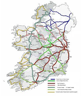
Roads in Ireland
are currently classified as motorways, National Primary routes, National secondary routes, Regional roads and Local roads. The introduction of this classification system began in 1977.
Prior to this, Ireland had a different road classification and numbering system. Roads fell into three categories: T (Trunk Roads), L (Link Roads) and unclassified roads. The origins of this system lie in pre-independence legislation: the preliminary section of Statutory Instrument S.I. No. 55/1926 — Road Signs and Traffic Signals Regulations, 1926 states that the Ministry of Transport Act, 1919 gave the Minister for Local Government and Public Health the power to assign a "route letter and number" to a road, while Section 6.4 of Part I of the Regulations specified the positioning of the "route letter and the number of the road" on directional signs. A reference in the Statutory Instrument to the "classification of roads as a 'Trunk' or 'Link' Road" indicates that a system of route classification and numbering was envisaged in the 1920s. However, at present, there is no information about when the Trunk and Link road-numbering system was actually introduced on signposts. Even though legal authority for the erection of directional signposts was given to local councils, the Automobile Association of Ireland
began an extensive road signposting scheme in 1938 which included comprehensive signposting of routes from Belfast
, Cork and Dublin.
Evidence that the Trunk Road and Link Road classification and numbering system had been well established by the 1950s is found in Statutory Instrument S.I. No. 284/1956 — Traffic Signs Regulations, 1956 which contains examples of several directional signs. The first and second examples show the T8 as the route to Wexford
and Rosslare
. In addition, Esso
road-maps of Ireland from the 1950s show the Trunk and Link road network. Despite its long-standing use, the original Trunk and Link road system was never legislated for and the routes of Trunk Roads and Link Roads were never formally designated by law.
 This current system of road classification, numbering and network management has its origins in the late 1960s. A 1969 study into road construction and management recommended a reclassification of the road system into national roads (primary and secondary), regional roads (primary and secondary) and county roads. This system, without the division of regional roads into primary and secondary categories, was later adopted.
On 23 July 1969 the Minister for Local Government, Kevin Boland
, announced that a national road network would be formed. In 1974, the Local Government (Roads and Motorways) Act came into effect. It allowed for designation of roads as motorways or national roads. National roads were first designated by Statutory Instrument S.I. No. 164/1977 on 1 June 1977. Twenty-five National Primary routes (N1-N25) and thirty-three National Secondary routes (N51-N83) were initially designated.
The changeover to the new system was gradual: a route planning map of Ireland from the late 1970s (or early 1980s), divided into a northern section and a southern section, shows a mixture of Trunk Road, Link Road and National route numbers. Many of the remaining classified roads became Regional roads (formally authorised under the Roads Act 1993, route-numbers having been present on road signs on a non-statutory basis for some years previously) and their routes were designated under a Statutory Instrument
('SI') in 1994. The latest SI designating the routes of Regional roads was published in 2006: the Roads Act 1993 (Classification of Regional Roads) Order 2006. Other roads formerly classified as Trunk or Link roads eventually became Local roads under the 1993 Act which states that "a public road, other than a national road or a regional road, shall be a local road".
The 1993 Act gave local authorities the duty to "assign a number or other identifying mark to each local road in respect of which it has responsibility". Local Road numbers have been used for administrative purposes since the Act came into effect, but Local Road numbers did not generally appear on directional signposts until the late 2000s. Most road-maps do not show Local Road numbers, although some are marked on OpenStreetMap
.
Older signs showing the former Trunk and Link road designations are still to be seen in some locations. The L (for Link Road) prefix on these signs is not connected to the network of Local roads currently in place.
 In 1979, in the wake of new EU laws and with the availability of EU funding, a strategic plan for the development of the national road network was published, entitled "Road Development Plan for the 1980s". The plan's main aims were:
The National Development Plan (1989–1993) set out a programme of road improvements costed at €1,257 million (1989 prices): it "included thirty-four major improvement projects involving the provision of dual carriageway or motorway on 290 kilometres of national primary routes"; another 290 kilometers were to be upgraded to wide single carriageway
standard (7.3 metre carriageway plus two 3 metre hard shoulders). A further €3,316 million (1994 prices) was spent on national primary routes between 1994 and 1999. Four key strategic corridors were identified for major improvements. These programmes meant that by the end of 1993, 35% of the national road network was "adequate or improved", 53% (with improvements to another 11% of the network underway) by the end of 1999.
Some changes were made to the national road network in the 1980s and 1990s. In 1980, two national secondary roads (N84
and N85
) were added to the network with the N86
being added in 1986. These roads had previously been either Trunk or regional roads. In 1994, three national secondary roads (N57, N64, N79) were reclassified as national primary road roads and subsequently renumbered (N57 to N26, N64 to part N18, N79 to N30) while a section of the N60
between Castlebar
and Westport
in Co. Mayo was reclassified as part of the N5. A section of the N56
between Letterkenny
and Stranorlar
in Co. Donegal was reclassified as a southern section of the N13.
Four other national primary routes (N27, N28, N29, N31) and one national secondary route (N87
, previously part of the R200 and R202 regional roads) were added to the network and the regional road between Killarney
and Killorglin
in Co. Kerry became part of the N72
. A section of the R600 regional road between Cork city centre and Cork Airport was reclassified as the N27, the N28 was partly newly constructed and partly a reclassified section of regional road (R609), the N29 was newly constructed and the N31 was made up of roads previously classified as regional roads. The N32 was added in 1996 and the N33 was added after its completion.
The National Roads Authority
(NRA) was established on a statutory basis by the Roads Act 1993 from 1 January 1994: "the Authority's primary function, under the Roads Act 1993, is 'to secure the provision of a safe and efficient network of national roads'. For this purpose, it has overall responsibility for planning and supervision of construction and maintenance works on these roads." Apart from the construction and maintenance of motorways and national roads, the NRA is responsible for providing traffic signs on national roads. Many of the larger schemes (some of which are tolled) initiated by the NRA have been built through public-private partnership
(PPP) arrangements which "has resulted in €2.1billion of private sector funding being secured for national road schemes."
 The 2000-2006 National Development Plan
(NDP) set new objectives for the development and improvement of Ireland's national road network. Several routes (the Major Inter-Urban routes) were selected for upgrading to motorway or high-quality dual carriageway
standard. This objective has since been modified and these routes will be motorway standard on completion. The development plan set out to achieve the following national road improvements:
Some of these objectives have been achieved while others are still progressing as of 2009. The M50
has been completed since 2005 but it is now being upgraded, the Dublin Port Tunnel
opened to all traffic on 28 January 2007, one major inter-urban route (the M1/N1 from Dublin to the border north of Dundalk) was completed in 2007 and good progress is being made on the other major inter-urban routes which are due for completion by the end of 2010. Major improvements have been made to other national primary routes, notably the N11 (Dublin-Wexford) and N18/N19 (Limerick-Shannon
-Galway) routes.
The latest development plan for national routes is incorporated into Transport 21
which sets out development objectives, including the completion of the Atlantic Corridor
(the Cork to Derry
corridor, plus the Cork to Waterford
route), to be achieved by 2015. Funding for national roads under the current National Development Plan (2007–2013) is €13.3 billion. As of 31 December 2007, there was a total of 5,427.58 km of national roads: 2,743.606 km of national primary routes (including motorways) and 2,683.974 km of national secondary routes. The total length of the national road network varies annually for different reasons:
The progress of national road construction projects can be tracked in the Road Scheme Activity section of the NRA's website, individual project websites and in the Infrastructure and Commuting & Transport sections of boards.ie
, an Irish internet forum
, which often contains more up-to-date information than official websites.
In addition to national roads, Ireland also has an extensive network of other public roads: there are 11,630
kilometres of regional roads and 78,972 kilometres of local roads. These roads have been allocated €4.3 billion over the lifetime of the current National Development Plan (2007–2013).
by-pass, which opened in 1983. Several major routes between Dublin (major inter-urban routes) and other cities are being (or have been) upgraded to motorway standard. As of 2009, all motorways in Ireland are part of, or form, national primary roads. There has been a considerable amount of motorway (and dual carriageway) construction in recent years: at the end of 2003 there were 176.33 km of motorway in the Republic and 244.79 km of dual carriageway forming part of national roads. By the end of 2004 there were 191.71 km of motorway and 285.49 km of dual carriageway. This was extended, by the end of 2005, to 246.62 km of motorway and 308.4 km of dual carriageway (including 2+1 road
s) and to 269.63 km of motorway and 352.91 km of dual carriageway (including 2+1 roads) by the end of 2006. By the end of 2007 there were 269.3 km of motorway, 405.62 km of dual carriageway and 38.99 km of 2+1 road. In 2008, another 125 km of newly constructed motorway were completed and some sections of dual carriageway on national routes were re-designated as motorways. There are 431 km of motorway and dual carriageway currently under construction with many more schemes at various planning stages; 145 km of newly constructed motorway and dual carriageway is due for completion in 2009, with another 286 km due for completion in 2010. If all these roads under construction are completed by 2010, there will be a total of 1231 km of motorway, high-quality dual carriageway and 2+2
roads out of approximately 2,740 km of national primary routes, about 45% of the national primary route network.
In June 2007, it was announced that around 800 km of roads would be either opened as motorways or re-designated as motorways if already opened under powers granted in the Roads Act 2007. In July 2008, S.I. No. 279 of 2008 was signed: it redesignated a number of roads, either already open, under construction or proposed, as motorways. A further proposed re-designation of roads was announced in September 2008. In December 2007, it was announced that a planned high quality dual carriageway scheme between Galway
and Tuam
would be built as a motorway, the first such new motorway project to be announced since the early 2000s. Another new motorway, the M20, is being planned as the main route between Cork
and Limerick
. The major inter-urban routes, most of the Cork to Tuam
section of the Atlantic Corridor
along the west coast and other routes will be motorway under these proposals.
By 2015, there will be approximately 1,050 km of motorway in Ireland:
If all these motorways are opened, Ireland will have a ratio of 1 km of motorway to every 4,277.56 people (assuming a population of 4.5 million) by 2015. This compares to a current ratio of 1 km of motorway to every 6,017.32 people in Belgium. Although welcomed by many people, the construction of new motorways in Ireland has not been without controversy or opposition. In particular, the construction of the M3 motorway through the archaeologically significant Tara-Skryne valley (or Gabhra) near Tara has led to protests and calls for protection of its landscape from many, including Pat Wallace, Director of the National Museum of Ireland
, and other prominent figures in Ireland and other countries. The Smithsonian Institution
in the US has placed the Hill of Tara archaeological complex on its list of endagered cultural treasures as a result of the M3's construction.
were built in the late 1920s and early 1930s. The Newtownards Road in Belfast had 'heavy traffic' in 1935-6 and the design of a bypass (later the Sydenham bypass) was discussed in the Stormont parliament; discussions about the need for a bypass had been going on for ten years. The first motorway in the whole of Ireland, the M1
, opened in 1962, fifteen years after plans for its construction were first discussed.
The first dual-carriageway in Northern Ireland was the Sydenham bypass, first begun in 1938 and fully opened in 1959. Northern Ireland's longest dual-carriageway is the A1
which connects Belfast to Newry
, continuing south to join the N1 at the border from where it continues mainly as motorway to Dublin. The A1 was gradually converted from single-carriageway to dual-carriageway between 1971 and 2009. The most extensive scheme planned at present is the up-grading of the A5 from Derry to the border at Aughnacoly, Co. Tyrone from single- to dual-carriageway as part of the A5 Western Transport Corridor. Sixty percent of the funding for this scheme has come from the government of the Republic.
The main roads in Northern Ireland, which connect well with those in the south, are classified "M"/"A"/"B" as in Great Britain. Whereas the roads in Great Britain are numbered according to a zonal system
, there is no available explanation for the allocation of road numbers in Northern Ireland, though their numbering is separate from the system in England
, Scotland
and Wales
. Public roads in Northern Ireland are managed by the Roads Service Northern Ireland. The Roads Service is the only roads authority in Northern Ireland and manages around 25,000 kilometres of public roads. The Roads Service was founded in 1996 as an executive agency of the Department of the Environment for Northern Ireland. In 1999, after devolution
it became part of the Northern Ireland Department for Regional Development. The Roads Services also operates a ferry
service across Strangford Lough
between the villages of Strangford
and Portaferry
.
. Plans to develop motorways were first announced by Major J R Perceval-Maxwell in the Northern Ireland Ministry of Commerce in 1946. Three 'approach roads', bypassing existing roads, were to be built in the greater Belfast area. In 1956, a modification of the original plans was announced: four motorways were to be built in the greater Belfast area. In 1964, ambitious plans to build a network of motorways throughout Northern Ireland were announced by Northern Ireland Minister of Home Affairs, William Craig. The plans included the construction of the following motorway schemes:
Legal authority for motorways existed in the Special Roads Act (Northern Ireland) 1963, similar to that in the Special Roads Act 1949
in Great Britain. The first motorway to open was the M1 motorway, though it did so under temporary powers until the Special Roads Act had been passed. Work on the motorways continued until the 1970s when the oil crisis
and the Troubles
both intervened causing the abandonment of many schemes. Only a small number of the motorways planned in 1964 were built: the M1 between Belfast and Dungannon, the M2 between Belfast and Antrim plus Ballymena bypass and the M22 from Antrim to Randalstown
. A short section of motorway, called the A8(M), from the M2 towards Larne was also built as were two urban motorways in Belfast, the M5, and the M3 which was the final motorway scheme to open. A short section of the M12 was also built and the A1 from near Lisburn to Newry has been up-graded to dual-carriageway in place of building the M11. The Belfast Urban Motorway was partially built in modified form as the A12 Westlink dual-carriageway. At present, Northern Ireland has 70.3 miles (113.1 km) of motorway.
Ireland
Ireland is an island to the northwest of continental Europe. It is the third-largest island in Europe and the twentieth-largest island on Earth...
connecting settlements and facilitating trade since ancient times and the country now has an extensive network of public road
Road
A road is a thoroughfare, route, or way on land between two places, which typically has been paved or otherwise improved to allow travel by some conveyance, including a horse, cart, or motor vehicle. Roads consist of one, or sometimes two, roadways each with one or more lanes and also any...
s connecting all parts of the island.
Early history
The first routes in Ireland were prehistoric trackways, some of which were later developed into roads suited for wheeled vehiclesWheel
A wheel is a device that allows heavy objects to be moved easily through rotating on an axle through its center, facilitating movement or transportation while supporting a load, or performing labor in machines. Common examples found in transport applications. A wheel, together with an axle,...
. Many of Ireland's minor roads “may well have had their origin in pre-existing paths and trackways aligned in direct response to the physical environment.” Traces of these evolved roads which developed over very long periods, frequently from tracks of the prehistoric period, are still evident. The routes of such roads usually followed the natural landscape, following the tops of ridges and crossing rivers and streams at fording points
Ford (crossing)
A ford is a shallow place with good footing where a river or stream may be crossed by wading or in a vehicle. A ford is mostly a natural phenomenon, in contrast to a low water crossing, which is an artificial bridge that allows crossing a river or stream when water is low.The names of many towns...
.
There is almost no evidence that large roads were constructed in Ireland during the Stone Age
Stone Age
The Stone Age is a broad prehistoric period, lasting about 2.5 million years , during which humans and their predecessor species in the genus Homo, as well as the earlier partly contemporary genera Australopithecus and Paranthropus, widely used exclusively stone as their hard material in the...
. However, a very large oval henge
Henge
There are three related types of Neolithic earthwork which are all sometimes loosely called henges. The essential characteristic of all three types is that they feature a ring bank and ditch but with the ditch inside the bank rather than outside...
enclosure, thought to date from c. 2500 BC (the Neolithic
Neolithic
The Neolithic Age, Era, or Period, or New Stone Age, was a period in the development of human technology, beginning about 9500 BC in some parts of the Middle East, and later in other parts of the world. It is traditionally considered as the last part of the Stone Age...
period) may possibly have had an ancient roadway associated with it. The henge was discovered at the Hill of Tara
Hill of Tara
The Hill of Tara , located near the River Boyne, is an archaeological complex that runs between Navan and Dunshaughlin in County Meath, Leinster, Ireland...
archaeological complex in geophysical surveys carried out between 1999 and 2001. It is unlikely that any roadway from this period would have been used as a transport route. Excavations carried out at Edercloon, Co. Longford in advance of road construction discovered a dense "network of wooden trackways and platforms, which were constructed from the Neolithic (c. 4000-c. 2200BC) to the early medieval period (c. AD 400-790)."
Wheeled vehicles with solid wooden disc-wheels were introduced into northern Europe
Northern Europe
Northern Europe is the northern part or region of Europe. Northern Europe typically refers to the seven countries in the northern part of the European subcontinent which includes Denmark, Estonia, Latvia, Lithuania, Norway, Finland and Sweden...
around 2000 BC. An example of a disc-wheel, from the Netherlands
Netherlands
The Netherlands is a constituent country of the Kingdom of the Netherlands, located mainly in North-West Europe and with several islands in the Caribbean. Mainland Netherlands borders the North Sea to the north and west, Belgium to the south, and Germany to the east, and shares maritime borders...
, was found next to a wooden trackway: "it appears from this evidence that the introduction of disc-wheeled carts into…northern Europe required the invention of roadbuilding about 2000 B.C." An Early Bronze Age
Bronze Age
The Bronze Age is a period characterized by the use of copper and its alloy bronze as the chief hard materials in the manufacture of some implements and weapons. Chronologically, it stands between the Stone Age and Iron Age...
trackway, from shortly after 2000 BC, was found at Ballykillen Bog, near Edenderry
Edenderry, County Offaly
Edenderry is a town in the north of County Offaly, Ireland. It is near the borders with Counties Kildare, Meath and Westmeath. The Grand Canal passes immediately south of the town through the Bog of Allen and there is a short spur to the town centre....
, Co. Offaly in the 19th century. It may have been designed to carry disc-wheeled vehicles. A one kilometre (0.6 mile) section of a wooden trackway, three feet (approx. 1 metre) wide, was surveyed at Corlona Bog in Co. Leitrim in the 1950s. The trackway was dated to approximately 1500 BC but its narrow width makes it unlikely that it was used by wheeled vehicles. Similar wooden trackways and roads are known from all over Ireland from the Late Bronze Age. One example from Ballyalbanagh, Co. Antrim was seven feet (2 metres) wide and made from oak beams and planks: "its width suggests provision for cart or wagon transport."
Archaeological excavations
Archaeology
Archaeology, or archeology , is the study of human society, primarily through the recovery and analysis of the material culture and environmental data that they have left behind, which includes artifacts, architecture, biofacts and cultural landscapes...
have found some roads built with stone in the Irish Iron Age
Iron Age
The Iron Age is the archaeological period generally occurring after the Bronze Age, marked by the prevalent use of iron. The early period of the age is characterized by the widespread use of iron or steel. The adoption of such material coincided with other changes in society, including differing...
. Ireland was never part of the Roman Empire
Roman Empire
The Roman Empire was the post-Republican period of the ancient Roman civilization, characterised by an autocratic form of government and large territorial holdings in Europe and around the Mediterranean....
and, therefore, Roman roads were not built in Ireland. However, a 22-kilometre long Iron Age road with a stone surface, part of a defensive complex, has been excavated in Munster
Munster
Munster is one of the Provinces of Ireland situated in the south of Ireland. In Ancient Ireland, it was one of the fifths ruled by a "king of over-kings" . Following the Norman invasion of Ireland, the ancient kingdoms were shired into a number of counties for administrative and judicial purposes...
: this, along with similar excavations, demonstrates that "Roman methods of road construction were known in Ireland." Generally, most surfaced tracks from this period were made with wood and were designed to facilitate travel through (or to) bogs. Togher
Corlea Trackway
The Corlea Trackway is an Iron Age trackway, or togher, near the village of Kenagh, south of Longford town, County Longford, in the Republic of Ireland. It was known locally as the Danes Road...
roads, a type of causeway
Causeway
In modern usage, a causeway is a road or railway elevated, usually across a broad body of water or wetland.- Etymology :When first used, the word appeared in a form such as “causey way” making clear its derivation from the earlier form “causey”. This word seems to have come from the same source by...
built through bogs, were found in many areas of the country.
Although law-tracts in Early Medieval Ireland described several different types of road, and Irish annals
Irish annals
A number of Irish annals were compiled up to and shortly after the end of Gaelic Ireland in the 17th century.Annals were originally a means by which monks determined the yearly chronology of feast days...
referred to a network of major highways, there is no evidence to suggest that Ireland ever had a network of roads as well developed as those found in the Roman Empire or other ancient societies. The road network remained underdeveloped throughout the Late Medieval and much of the Early Modern periods: it was not until the 18th century that an extensive system of roads suitable for long-distance travel was developed. Newly built roads were relatively wide and straight, many still form the backbone of the current major roads network. The development of roads continued throughout the early 19th century until the arrival of the railways which became the dominant form of land transport from the 1840s-1850s onwards. The development of the internal combustion engine
History of the internal combustion engine
Although various forms of internal combustion engines were developed before the 19th century, their use was hindered until the commercial drilling and production of petroleum began in the mid-1850s...
and of motorised vehicles led to increases in traffic on roads which were developed and improved as a result. Ireland's roads have continued to develop and improve up to the present day. Various development programmes have successively increased the number of motorways and dual carriageway
Dual carriageway
A dual carriageway is a class of highway with two carriageways for traffic travelling in opposite directions separated by a central reservation...
s within the national roads network while other roads have had their surfaces and signposting improved.
Roads in medieval Ireland
According to an entry in the Annals of the Four MastersAnnals of the Four Masters
The Annals of the Kingdom of Ireland or the Annals of the Four Masters are a chronicle of medieval Irish history...
for AD 123, there were five principal highways leading to Tara
Hill of Tara
The Hill of Tara , located near the River Boyne, is an archaeological complex that runs between Navan and Dunshaughlin in County Meath, Leinster, Ireland...
in Early Medieval Ireland. The entry in the Annals claims that these routes were 'discovered' at the birth of Conn of the Hundred Battles
Conn of the Hundred Battles
Conn Cétchathach , son of Fedlimid Rechtmar, was, according to medieval Irish legend and historical tradition, a High King of Ireland, and the ancestor of the Connachta, and, through his descendant Niall Noígiallach, the Uí Néill dynasties, which dominated Ireland in the early middle ages, and...
:
The night of Conn's birth were discovered five principal roads leading to Teamhair, which were never observed till then. These are their names: Slighe Asail, Slighe Midhluachra, Slighe Cualann, Slighe Mhór, Slighe Dala. Slighe Mhór is that called Eiscir Riada, i.e. the division line of Ireland into two parts, between Conn and Eoghan Mór.
In reality, "the ancient road system (such as it was - there cannot have been a developed national system) fanned out not from Tara but from Dublin.".
The Slighe Assail went due west towards Lough Owel
Lough Owel
Lough Owel is a lough in the Midlands of Ireland, situated north of Mullingar, the county town of Westmeath. It is a deep lake, well known amongst anglers, and holds a few char along with brown trout. Water from Lough Owel feeds the Royal Canal, a canal crossing Ireland from Dublin to the River...
in Co. Westmeath, then to Cruachain. The Slighe Midluachra
Slige Midluachra
Slige Midluachra is the old northern road sometimes known High Kings Road that ran in ancient times from Tara to Dunseverick on the north coast of Ireland.It was one of the legendary Five Roads of Tara, site of the ancient Seat of Ireland's High Kings...
went towards Slane
Slane
Slane is a village in County Meath, in Ireland. The village stands on a steep hillside on the left bank of the River Boyne at the intersection of the N2 and the N51 . In 2006 Slane's population was 1,099, having grown from 823 in 2002. The population of the village and the surrounding rural area...
, through the Moyry Pass
Battle of Moyry Pass
The Battle of Moyry Pass was fought during September and October 1600 in counties Armagh and Louth, in the north of Ireland, during the Nine Years' War...
north of Dundalk
Dundalk
Dundalk is the county town of County Louth in Ireland. It is situated where the Castletown River flows into Dundalk Bay. The town is close to the border with Northern Ireland and equi-distant from Dublin and Belfast. The town's name, which was historically written as Dundalgan, has associations...
, round the base of Slieve Fuaid, near Newtownhamilton
Newtownhamilton
Newtownhamilton is a small village in County Armagh, Northern Ireland. It is within the townland of Tullyvallan and the barony of Upper Fews. It is part of the Newry and Mourne District Council area...
in Co. Armagh, to Emain Macha
Emain Macha
]Navan Fort – known in Old Irish as Eṁaın Ṁacha and in Modern Irish as Eamhain Mhacha – is an ancient monument in County Armagh, Northern Ireland. According to Irish legend, it was one of the major power centers of pre-Christian Ireland...
, ending at Dunseverick
Dunseverick
Dunseverick is a hamlet and townland near the Giant's Causeway in County Antrim, Northern Ireland. It is most notable for Dunseverick Castle.-External links:****...
on the north coast of Co. Antrim. The Slighe Cualann ran south-east through Dublin, crossing the River Liffey
River Liffey
The Liffey is a river in Ireland, which flows through the centre of Dublin. Its major tributaries include the River Dodder, the River Poddle and the River Camac. The river supplies much of Dublin's water, and a range of recreational opportunities.-Name:The river was previously named An Ruirthech,...
via a hurdle-bridge, then went south "through the old district of Cualann, which it first entered a little north of Dublin, and from which it took its name". The Slighe Dala ran towards and through Ossory
Kingdom of Osraige
The Kingdom of Osraighe , anglicized as Ossory, was an ancient kingdom of Ireland. It formed the easternmost part of the kingdom and province of Munster until the middle of the 9th century, after which it attached itself to Leinster...
in Co. Kilkenny. Finally, the Slighe Mhór ('Great Highway') joined the Esker Riada
Esker Riada
Esker Riada, , is a system of ridges that stretch across the middle of Ireland, between Dublin and Galway.-Geography:The Esker Riada is a collection of eskers, that passes through the counties of Dublin, Meath, Kildare, Westmeath, Offaly, Roscommon and Galway...
. It then, more-or-less, followed the Esker Riada to Co. Galway.
Unlike Roman roads, these routes were not clearly physically defined:
It is important to remember that unlike, for example, Roman roads, these medieval routes were not essentially physical entities—thin strips of land with physical boundaries; rather they were rights of way, sometimes with legal and traditional status. Routes tended to follow the line of least resistance, twisting and turning to avoid poorly drained areas and land that was easily overlooked. Where there was a hill to climb or a difficult area to pass through, multiple tracks would develop, the traveller taking the easiest route. Routes may also have varied seasonally as changing weather affected the condition of the pathway.
(L. Doran: Medieval Communications Routes, 69).
Early medieval road terminology
Early medieval law-tracts set out five types of road:the 'highway', slige, on which two carpait/carpenta [chariots] could pass without one having to give way to the other, the 'local road', rout [or ród], on which at least one carpat/carpentum and two riders can pass side by side as a regional main road, the 'connecting road', lámraite, a minor road connecting two major roads, the 'side road', tógraite, leading to a forest or a river, which private persons could rent, for which they then could extract tolls from people driving cattle on them , and finally the 'cow road', bóthar, which still had to be as wide as two cows, one standing parallel and one normal to the road.(F. Kelly, Early Irish Farming. Early Irish Law Series vol. IV, Dublin 1997, 390 f.)
Conair and cai were general terms, given in Cormac's Glossary, for any type of road and "thirty-seven ancient roads [were] mentioned with the general name bealach", meaning 'pass
Mountain pass
A mountain pass is a route through a mountain range or over a ridge. If following the lowest possible route, a pass is locally the highest point on that route...
'. Cásan was a term used for a path and a ceis was a path made of wattles.
The word bóthar is now the most commonly used term for road in modern Irish
Irish language
Irish , also known as Irish Gaelic, is a Goidelic language of the Indo-European language family, originating in Ireland and historically spoken by the Irish people. Irish is now spoken as a first language by a minority of Irish people, as well as being a second language of a larger proportion of...
: its diminutive
Diminutive
In language structure, a diminutive, or diminutive form , is a formation of a word used to convey a slight degree of the root meaning, smallness of the object or quality named, encapsulation, intimacy, or endearment...
form, bóithrín, (or boreen
Boreen
Boreen or bohereen is an anglicised, Hiberno-English term normally meaning a narrow, frequently unpaved, rural road in Ireland. "Boreen" also appears sometimes in names of minor urban roads such as Saint Mobhi Bóithrín , commonly known as Mobhi Boreen in Glasnevin, Dublin....
in English
English language
English is a West Germanic language that arose in the Anglo-Saxon kingdoms of England and spread into what was to become south-east Scotland under the influence of the Anglian medieval kingdom of Northumbria...
) is used as a term for very narrow, rural roads.
Pre-Norman
Normans
The Normans were the people who gave their name to Normandy, a region in northern France. They were descended from Norse Viking conquerors of the territory and the native population of Frankish and Gallo-Roman stock...
bridges were not built of stone: bridges were made of timber, sometimes supported by natural rock or on artificial piers. Toirdelbach Ua Briain was said to have built a wooden bridge across the Shannon
River Shannon
The River Shannon is the longest river in Ireland at . It divides the west of Ireland from the east and south . County Clare, being west of the Shannon but part of the province of Munster, is the major exception...
at Killaloe
Killaloe, County Clare
Killaloe is a large village in east County Clare, Ireland, situated in the midwest of Ireland. The village is on the south end of Lough Derg, while the settlement spreads across the River Shannon, with the County Tipperary side known as Ballina...
in 1071. Geoffrey Keating
Geoffrey Keating
Seathrún Céitinn, known in English as Geoffrey Keating, was a 17th century Irish Roman Catholic priest, poet and historian. He was born in County Tipperary c. 1569, and died c. 1644...
's History of Ireland notes the building of bridges among the achievements of Toirdelbach Ua Conchobair (1088–1156): "This Toirrdhealbhach built three chief bridges in Connaught, to wit, the bridge of Ath Luain and the bridge of Ath Crochdha on the Sionainn and the bridge of Dun Leoghdha on the Succa." Some "bridges were constructed of strong hurdles supported on piles". A bridge of this type gave Dublin its Irish name: Baile Átha Cliath, 'Town of the Hurdled Ford'.
Esker Riada
The Esker RiadaEsker Riada
Esker Riada, , is a system of ridges that stretch across the middle of Ireland, between Dublin and Galway.-Geography:The Esker Riada is a collection of eskers, that passes through the counties of Dublin, Meath, Kildare, Westmeath, Offaly, Roscommon and Galway...
is a system of ridges, or esker
Esker
An esker is a long winding ridge of stratified sand and gravel, examples of which occur in glaciated and formerly glaciated regions of Europe and North America...
s, that stretches across the narrowest point of Ireland, between Dublin and Galway.
Because the slightly higher ground of the Esker Riada provided a route through the bogs of the Irish midlands it has, since ancient times, formed a highway joining the east and west of Ireland: its ancient Irish
Irish language
Irish , also known as Irish Gaelic, is a Goidelic language of the Indo-European language family, originating in Ireland and historically spoken by the Irish people. Irish is now spoken as a first language by a minority of Irish people, as well as being a second language of a larger proportion of...
name was An Slighe Mhór meaning ‘The Great Highway’. The route of the present Dublin-Kinnegad
Kinnegad
Kinnegad or Kinagad is a town in County Westmeath, Ireland. It is near the border with County Meath, at the junction of the N6 and the N4 - two of Ireland's main east-west roads...
-Galway
Galway
Galway or City of Galway is a city in County Galway, Republic of Ireland. It is the sixth largest and the fastest-growing city in Ireland. It is also the third largest city within the Republic and the only city in the Province of Connacht. Located on the west coast of Ireland, it sits on the...
road (N4, M4, N6, M6
M6 motorway (Ireland)
The M6 motorway is a motorway in Ireland, which runs from Dublin to Galway. The M6 extends from its junction with the M4 at Kinnegad all the way west to the outskirts of Galway City, but the Athlone bypass and the approach to Galway city - while of dual carriageway standard - have not been...
) very approximately follows the route of the Esker Riada.
The Esker Riada also formed an ancient division of Ireland between Leath Cuinn
Leath Cuinn
Leath Cuinn and Leath Moga refers to a legendary ancient division of Ireland.-Geographical extant:Leath Cuinn was the island north of the Esker Riada...
(‘Conn’s Half’) to the north, and Leath Mogha
Leath Cuinn
Leath Cuinn and Leath Moga refers to a legendary ancient division of Ireland.-Geographical extant:Leath Cuinn was the island north of the Esker Riada...
(‘Mogha’s Half’) to the south.
Late medieval roads
Roads were not the most important transport routes in later medieval Ireland: most long-distance travel between towns was undertaken by sea or via inland waterways. Road conditions were difficult, often dangerous, and long-distance travel by road was generally slow and uncomfortable. Giraldus CambrensisGiraldus Cambrensis
Gerald of Wales , also known as Gerallt Gymro in Welsh or Giraldus Cambrensis in Latin, archdeacon of Brecon, was a medieval clergyman and chronicler of his times...
gives an indication of the slowness of travel in 12th century Ireland, which he also describes as a "truly a desert land [i.e. sparsely populated], without roads, but well watered."
...Ireland extends from the Brandane mountains to the island of Columba, called Thorach, the length of eight good Irish days' journey, which is forty miles to the day; and from Dublin to St. Patrick's hills and the sea of Connaught it is four such days' journey in breadth.
Travel by sea was faster than by land and it was easier to transport goods in bulk by ship than by road; one estimate reckons that a ship could travel sixty to ninety miles (96 km to 145 km) per day whereas an overland traveller might cover a distance of only twenty-five miles (40 km).
Most tracks were not suitable for wheeled vehicles and pack animals were used to transport goods. Some attempts to improve routes were made in the Tudor
Tudor dynasty
The Tudor dynasty or House of Tudor was a European royal house of Welsh origin that ruled the Kingdom of England and its realms, including the Lordship of Ireland, later the Kingdom of Ireland, from 1485 until 1603. Its first monarch was Henry Tudor, a descendant through his mother of a legitimised...
period: "efforts were made to free main rivers of weirs that blocked transport, and military considerations accelerated road- and bridge-building, yet methods were somewhat unscientific and planning was haphazard." Despite these efforts, overland travel remained slow. In 1558, it took Thomas Radclyffe, 3rd Earl of Sussex
Thomas Radclyffe, 3rd Earl of Sussex
Thomas Radclyffe 3rd Earl of Sussex was Lord-Lieutenant of Ireland during the Tudor period of English history, and a leading courtier during the reign of Elizabeth I.- Family:...
and Lord Deputy of Ireland
Lord Deputy of Ireland
The Lord Deputy was the King's representative and head of the Irish executive under English rule, during the Lordship of Ireland and later the Kingdom of Ireland...
, two days to travel about sixty miles (c. 100 km) from Limerick
Limerick
Limerick is the third largest city in the Republic of Ireland, and the principal city of County Limerick and Ireland's Mid-West Region. It is the fifth most populous city in all of Ireland. When taking the extra-municipal suburbs into account, Limerick is the third largest conurbation in the...
to Galway.
17th century
In 1614, the Irish ParliamentParliament of Ireland
The Parliament of Ireland was a legislature that existed in Dublin from 1297 until 1800. In its early mediaeval period during the Lordship of Ireland it consisted of either two or three chambers: the House of Commons, elected by a very restricted suffrage, the House of Lords in which the lords...
passed the Highways Act which required local parishes to maintain roads within their boundaries serving market towns. The Act did not regulate the construction of new roads or bridges although it did encourage improvements to existing roads and the construction of new ones, especially roads linking market towns in the Ulster Plantation area. The organisation of road maintenance on a parochial basis is partly responsible for the large numbers of minor roads found throughout Ireland. In 1634, a new Act allowed for the levying of a tax "to ensure the repair, maintenance or reconstruction of bridges, fords or causeways." This formed the basis of the presentment system which was the main system for organising the construction and repair of roads and bridges in Ireland from 1634 to 1898.
The difficulties encountered by travellers on 17th century Irish roads are amply illustrated by extracts from contemporary accounts of journeys.
A military gentleman going from NewryNewryNewry is a city in Northern Ireland. The River Clanrye, which runs through the city, formed the historic border between County Armagh and County Down. It is from Belfast and from Dublin. Newry had a population of 27,433 at the 2001 Census, while Newry and Mourne Council Area had a population...
to DownpatrickDownpatrickDownpatrick is a medium-sized town about 33 km south of Belfast in County Down, Northern Ireland. It is the county town of Down with a rich history and strong connection to Saint Patrick. It had a population of 10,316 at the 2001 Census...
in 1602 recounts that ...before we had ridden three miles we lost our way and were compelled to go on foot, leading our horses through bogs and marshes... The journey took two days. A few years later an account of the journey of a Scotsman through Ireland in 1619 and 1620 reflects the great difficulties which he encountered: Travelling in winter his horse constantly sank to its girths on the boggy roads, and his saddles and saddlebags were destroyed. Often he had to cross streams by swimming his horse, a dangerous procedure for, as he tells us, in five months he has foundered six horses.
From such accounts it may be deduced that in general whatever roads and tracks did exist at this time were quite unfit for use by any form of wheeled vehicle.
18th century
By the 18th century, Ireland had a well-developed network of roads, the principal ones being marked on Herman MollHerman Moll
Herman Moll , was a cartographer, engraver, and publisher. Moll moved to England in 1678 and opened a book and map store in London...
's New Map of Ireland (1714) which showed, amongst other features, "Passes, Bridges &c. with the Principal Roads, and the common Reputed Miles" between towns.
In 1765, new legislation gave county Grand Juries the power to "...present such sum or sums of money, as they shall think fit, upon any barony or baronies in such county for the repairing [of] old roads or making new roads through such barony or baronies...". The presentment system of funding roads lasted until 1898 and it was successful in providing Ireland with a system of public roads which English travellers such as Arthur Young commented favourably on:
...for a country so very far behind us as Ireland to have got suddenly so much the start of us in the article of roads is a spectacle that cannot fail to strike the English traveller exceedingly.
New roads had to be at least 30 feet (9.14 metres) wide between fences and drains, with a 14 feet (4.27 metres) wide gravelled surface. In 1777, maintenance contracts, allowing for regular maintenance, were established. Taylor and Skinner's Maps of the Roads of Ireland was first published in 1778 , with a second, revised edition in 1783. It provided detailed strip maps of the principal roads along with other topographical details.
From 1729, a network of turnpike roads
Turnpike trust
Turnpike trusts in the United Kingdom were bodies set up by individual Acts of Parliament, with powers to collect road tolls for maintaining the principal highways in Britain from the 17th but especially during the 18th and 19th centuries...
(charging tolls) was built: "a turnpike was a primitive form of turnstile - a gate across the road, opened on payment of a toll. The average length of a turnpike road was 30 miles". Routes to and from Dublin were developed initially and the network spread throughout the country. Turnpikes operated between 1729 and 1858 when the extensive railway network made them increasingly unpopular. Turnpike roads were not as widely used in Ireland as they were in England
England
England is a country that is part of the United Kingdom. It shares land borders with Scotland to the north and Wales to the west; the Irish Sea is to the north west, the Celtic Sea to the south west, with the North Sea to the east and the English Channel to the south separating it from continental...
because of the availability of toll-free alternatives, the roads built under the presentment system. Lack of traffic on some routes led to reduced toll income and maintenance was neglected. However, in the first quarter of the 19th century, mail-coach contracts increased income and the quality of turnpike roads improved. Turnpike roads were also used by horse-drawn carriage services, including the Bianconi coaches, established as a form of public transport
Public transport
Public transport is a shared passenger transportation service which is available for use by the general public, as distinct from modes such as taxicab, car pooling or hired buses which are not shared by strangers without private arrangement.Public transport modes include buses, trolleybuses, trams...
by Charles Bianconi
Charles Bianconi
-Life and work:Born Carlo Bianconi in Costa Masnaga on September 24, 1786, he moved from an area poised to fall to Napoleon and travelled to Ireland in 1802, via England, just four years after the 1798 rebellion. At the time, British fear of continental invasion resulted in an acute sense of...
in 1815. By 1820, there were around 1,500 miles of turnpike roads in Ireland but this had fallen to 300 miles by 1856 when competition from the railways made many turnpike roads unprofitable. By 1858, turnpike roads in Ireland had been abolished.
Apart from roads themselves, traces of the turnpike roads exist physically as milestone
Milestone
A milestone is one of a series of numbered markers placed along a road or boundary at intervals of one mile or occasionally, parts of a mile. They are typically located at the side of the road or in a median. They are alternatively known as mile markers, mileposts or mile posts...
s and other features: there is a former toll-booth (18th or 19th-century) at Saint Luke's Cross in Cork. Some Irish placenames reflect the turnpike system: there are areas of Cork called Dublin Pike and Kerry Pike (as in turnpike) and the area at the junction of the N75
N75 road (Ireland)
The N75 road is a national secondary road in Ireland. It runs for its entire length in County Tipperary, east to west from Thurles to its junction with the M8 motorway close to the village of Two-Mile-Borris.The N75 is only in length.-See also:...
and the R639
R639 road
The R639 road is one of Ireland's regional roads. Once designated the N8 national primary road , it was reclassified in stages as the R639 following the progressive opening of sections of the M8 motorway, which rendered the single carriageway N8 redundant as a national primary road...
(old N8) in County Tipperary
County Tipperary
County Tipperary is a county of Ireland. It is located in the province of Munster and is named after the town of Tipperary. The area of the county does not have a single local authority; local government is split between two authorities. In North Tipperary, part of the Mid-West Region, local...
is called Turnpike.
19th century
BelmulletBelmulletBelmullet is a coastal Gaeltacht town with a population of around 2,000 on the Mullet Peninsula in the barony of Erris, County Mayo, Ireland. Its name means the "mouth of the mullet"...
had only three houses when the first wheeled vehicle arrived in 1823, but ten years later boasted 185 houses, together with corn-stores, shops and hotels.
In 1831, the Board of Public Works (Ireland) was set up. It had a wide range of public duties including the building of roads and bridges. The Irish Board of Public Works
Office of Public Works
The Office of Public Works is a State Agency of the Department of Finance in the Republic of Ireland...
took over the grants scheme for newly built roads in 1832 and by 1848 was responsible for the administration of 1600 kilometres (994.2 mi) of roads. Most of the major trunk roads in the north of Ireland were improved by the Board and a number of new routes, including the coast road between Larne
Larne
Larne is a substantial seaport and industrial market town on the east coast of County Antrim, Northern Ireland with a population of 18,228 people in the 2001 Census. As of 2011, there are about 31,000 residents in the greater Larne area. It has been used as a seaport for over 1,000 years, and is...
and Ballycastle
Ballycastle, County Antrim
Ballycastle is a small town in County Antrim in Northern Ireland. Its population was 5,089 people in the 2001 Census. It is the seat and main settlement of Moyle District Council....
in Co. Antrim and the road between Strabane
Strabane
Strabane , historically spelt Straban,is a town in west County Tyrone, Northern Ireland. It contains the headquarters of Strabane District Council....
and Derry
Derry
Derry or Londonderry is the second-biggest city in Northern Ireland and the fourth-biggest city on the island of Ireland. The name Derry is an anglicisation of the Irish name Doire or Doire Cholmcille meaning "oak-wood of Colmcille"...
(now part of the A5 road
A5 road (Northern Ireland)
The A5 is a major primary route in Northern Ireland. It travels through County Londonderry and County Tyrone, commencing in the city of Derry, passing the large towns of Strabane and Omagh before it meets the N2 across the border in the Republic of Ireland towards the final destination of...
). Smaller road schemes were initiated by the Congested Districts Board
Congested Districts Board for Ireland
The Congested Districts Board for Ireland was established by the Chief Secretary, Arthur Balfour in 1891 to alleviate poverty and "congested" living conditions in the west of Ireland....
from 1891.
In the meantime, an 1805 Act of parliament required the Postmaster General
Postmasters General of Ireland
The Postmasters General of Ireland, held by two people simultaneously, was a new appointment set up as part of the establishment of the Irish Post Office independent from that of Great Britain, by the Act 23, 24 George III in 1784. The post lasted nearly fifty years...
to survey roads used by mail coaches and suggest improvements, including the widening of roads to a minimum width of 42 feet (12.8 metres). From 1805 to 1811, over 3200 kilometres (1,988.4 mi) of post roads were surveyed by Major Alexander Taylor and his staff. Various improvements to existing roads were made and some new roads were built, for example, the road from Dublin to Slane (now part of the N2 and R135
R135 road
The R135 road is one of Ireland's newest regional roads, being a reclassification of those sections of the former N2 which were bypassed when the N2 Ashbourne By-Pass dual carriageway opened in 2006, and when the Carrickmacross, Castleblayney & Monaghan bypasses were completed.-References:* – ...
roads).
Specialist routes to facilitate the butter
Butter
Butter is a dairy product made by churning fresh or fermented cream or milk. It is generally used as a spread and a condiment, as well as in cooking applications, such as baking, sauce making, and pan frying...
trade, which centered on Cork, were built in Munster. The first butter road was commissioned in 1748 and was built by John Murphy of Castleisland
Castleisland
Castleisland is a town and commercial centre in County Kerry in south west Ireland. The town is renowned for the width of its main street. Castleisland has a population of 2,170....
in Co. Kerry: "one of his routes, opened in 1829, reduced the distance between Cork and Listowel from 102 to 66 miles – quite a feat, given the rough countryside over which it ran. Another, linking Cork with Killarney
Killarney
Killarney is a town in County Kerry, southwestern Ireland. The town is located north of the MacGillicuddy Reeks, on the northeastern shore of the Lough Lein/Leane which are part of Killarney National Park. The town and its surrounding region are home to St...
via Macroom
Macroom
Macroom is a market town in Ireland located in a valley on the River Sullane, a tributary of the River Lee, between Cork and Killarney. It is one of the key gateways to the tourist region of West Cork. The town recorded a population on 3,553 in the 2006 national census...
and Glenflesk, came down to 57 miles from 88".
In other areas, notably in Co. Wexford and Co. Wicklow, military roads were built to help secure British military control over remote areas. The Military Road through Co. Wicklow was begun in 1800 and completed in 1809. The R115
R115 road
The R115 road is a regional road in counties Dublin and Wicklow in Ireland. It follows the Military Road for its entire length. The R115 is long; the full length of the Military Road is...
is part of the Military Road for its entire length.
Many roads built in the 18th- and 19th-centuries formed the basis of the existing network of National Primary
National primary road
A national primary road is a road classification in the Republic of Ireland. National primary roads form the major routes between the major urban centres. There are over 2,700km of national primary roads. This category of road has the prefix "N" followed by one or two digits...
, National Secondary
National secondary road
A national secondary road is a category of road in Ireland. These roads form an important part of the national route network, but are secondary to the main arterial routes which are classified as national primary roads. National secondary roads are designated with route numbers higher than those...
and Regional road
Regional road
A regional road in Ireland is a class of road not forming a major route , but nevertheless forming a link in the national route network. There are over 11,600 kilometres of regional roads. Regional roads are numbered with three digit route numbers, prefixed by "R" A regional road in Ireland is a...
s (formerly Trunk and Link roads
Trunk Roads in Ireland
Ireland has an extensive network of public roads which connect all parts of the country with each other. Roads in Ireland are currently classified as motorways, National Primary routes, National secondary routes, Regional roads and Local roads. The introduction of this classification system began...
) in the Republic of Ireland
Republic of Ireland
Ireland , described as the Republic of Ireland , is a sovereign state in Europe occupying approximately five-sixths of the island of the same name. Its capital is Dublin. Ireland, which had a population of 4.58 million in 2011, is a constitutional republic governed as a parliamentary democracy,...
and the main roads in Northern Ireland
Northern Ireland
Northern Ireland is one of the four countries of the United Kingdom. Situated in the north-east of the island of Ireland, it shares a border with the Republic of Ireland to the south and west...
.
20th century onwards
The 20th century saw a renewed emphasis on roads as the primary method of facilitating land transport. The increase in motor vehicle traffic on roads meant that urgent improvements were required to make roads suitable for all vehicles in the automobile
Automobile
An automobile, autocar, motor car or car is a wheeled motor vehicle used for transporting passengers, which also carries its own engine or motor...
age.
In 1909, a Road Board was set up to improve roads. It was initially funded by a tax on motor fuel and a later a licence duty on cars, the Road Fund
Road Fund
The Road Fund was a British Government fund designated to pay for the building and maintenance of the United Kingdom road network. Its income came originally from vehicle excise duty, until that ceased to be hypothecated for roads use in 1936, and then from government grants...
. Road surfaces were improved and roads were widened and straightened using money raised by the Road Fund. The Road Board was abolished in 1919 when its functions were transferred to the newly established Ministry of Transport
Department for Transport
In the United Kingdom, the Department for Transport is the government department responsible for the English transport network and a limited number of transport matters in Scotland, Wales and Northern Ireland which are not devolved...
. In 1922, after the foundation of the Irish Free State
Irish Free State
The Irish Free State was the state established as a Dominion on 6 December 1922 under the Anglo-Irish Treaty, signed by the British government and Irish representatives exactly twelve months beforehand...
, the Minister for the Environment and Local Government took over the functions of the Ministry of Transport. In 2002, the newly renamed Department of Transport
Department of Transport (Ireland)
The Department of Transport, Tourism and Sport is a department of the Government of Ireland that is responsible for transport policy and overseeing transport services and infrastructure. The Department is led by the Minister for Transport, Tourism and Sport who is assisted by two Ministers of State...
took over responsibility for national roads. From 1921-1922 onwards, the partition of Ireland
Partition of Ireland
The partition of Ireland was the division of the island of Ireland into two distinct territories, now Northern Ireland and the Republic of Ireland . Partition occurred when the British Parliament passed the Government of Ireland Act 1920...
has led to different paths in the evolution of public road networks in Northern Ireland and the rest of Ireland. Responsibility for roads in Northern Ireland fell on the Stormont
Parliament of Northern Ireland
The Parliament of Northern Ireland was the home rule legislature of Northern Ireland, created under the Government of Ireland Act 1920, which sat from 7 June 1921 to 30 March 1972, when it was suspended...
administration from 1921 to 1972. In 1996, the Northern Ireland Roads Service was set up; it became an agency of the Northern Ireland Department for Regional Development when devolved government
Northern Ireland Executive
The Northern Ireland Executive is the executive arm of the Northern Ireland Assembly, the devolved legislature for Northern Ireland. It is answerable to the Assembly and was established according to the terms of the Northern Ireland Act 1998, which followed the Good Friday Agreement...
was restored in 1999.
Several other differences, including in road classification and route-numbering, speed-limits, directional sign-posting and warning and regulatory signposting have developed since the 1920s. Signs
Road signs in the United Kingdom
Road signs in the United Kingdom conform broadly to European norms, though a number of signs are unique to Britain and direction signs omit European route numbers.-History:...
in Northern Ireland denote distances in miles, while all directional signs placed in the Republic since the 1970s use kilometres. Currently speed limits in miles per hour (mph) are used north of the border; those in the Republic
Road speed limits in the Republic of Ireland
Road speed limits in the Republic of Ireland apply on all public roads in the country. These are signposted and legislated for in kilometres per hour. Speed limits are demarcated by regulatory road signs . These consist of white circular signs with a red outline. Speed limits are marked in black...
are in kilometres per hour (km/h). Metric speed limits were introduced on 20 January 2005, this involved the provision of 58,000 new metric speed limit signs, replacing 35,000 imperial signs. The Republic's road signs are bilingual, using both of the state's official languages, Irish
Irish language
Irish , also known as Irish Gaelic, is a Goidelic language of the Indo-European language family, originating in Ireland and historically spoken by the Irish people. Irish is now spoken as a first language by a minority of Irish people, as well as being a second language of a larger proportion of...
and English
English language
English is a West Germanic language that arose in the Anglo-Saxon kingdoms of England and spread into what was to become south-east Scotland under the influence of the Anglian medieval kingdom of Northumbria...
while those in Northern Ireland are in English only. Northern Ireland uses directional, regulatory and warning signage which is almost identical to that used in Great Britain
Great Britain
Great Britain or Britain is an island situated to the northwest of Continental Europe. It is the ninth largest island in the world, and the largest European island, as well as the largest of the British Isles...
. Warning signs have black symbols on a white background with a red border, enclosed in a triangle-shaped sign. However, from 1956, the Republic of Ireland has used diamond-shaped warning signs, with black symbols or writing on a yellow (reddish-orange for temporary signs) background, similar to the signs used in the US and Australia
Australia
Australia , officially the Commonwealth of Australia, is a country in the Southern Hemisphere comprising the mainland of the Australian continent, the island of Tasmania, and numerous smaller islands in the Indian and Pacific Oceans. It is the world's sixth-largest country by total area...
.
Roads in the Republic are signed with M (for motorways
Motorways in the Republic of Ireland
In Ireland, the highest category of road is a Motorway , indicated by the prefix M followed by one or two digits...
), N (for national roads), R (for regional roads) and L (for Local roads
Local Roads in Ireland
A Local Road in Ireland is a class of public road not classified as a National road or as a Regional road but nevertheless forming a link in the national network of roads...
). The appearance of L road-numbers on signposts only began in 2006, along with European route numbers on some major roads. Roads in Northern Ireland are signed with M (for motorways), A (for A-class roads) and B (for B-class roads). There are also C-class roads in Northern Ireland but these road-numbers are not currently shown on signposts.
The introduction of metric speed limits has led to the erection of signs warning motorists of the change to either the metric
Metric system
The metric system is an international decimalised system of measurement. France was first to adopt a metric system, in 1799, and a metric system is now the official system of measurement, used in almost every country in the world...
or imperial systems at the border. Differing road-numbering systems also mean that some signs in Northern Ireland display route-numbers used in the Republic and vice versa.
Road improvements: 1920s to 1950s
In 1922, the Irish Free State took over a network of public roads which required major improvements. Most road surfaces were made up of undressed and unrolled water-bound macadamMacadam
Macadam is a type of road construction pioneered by the Scotsman John Loudon McAdam in around 1820. The method simplified what had been considered state-of-the-art at that point...
which did not use tar
Tar
Tar is modified pitch produced primarily from the wood and roots of pine by destructive distillation under pyrolysis. Production and trade in tar was a major contributor in the economies of Northern Europe and Colonial America. Its main use was in preserving wooden vessels against rot. The largest...
as a sealant.
Under the Local Government Act, 1925 the construction and maintenance of main roads and county roads became the responsibility of local county council
County council
A county council is the elected administrative body governing an area known as a county. This term has slightly different meanings in different countries.-United Kingdom:...
s. Main roads and county roads were funded by the county less the urban districts and urban roads were funded by the urban districts.
The 1925 Act also granted powers to order the removal or alteration of buildings, trees and hedges causing obstruction or danger, introduced a licensing system for the erection of petrol pumps and introduced powers to set speed limits and to regulate signposts.
Grants were made to local councils from the Road Fund for the improvement of roads and, later, their maintenance. By the 1930s, “the surfaces of the main roads had all been improved and attention could then be given to widening and improving alignment.” Main roads now had tarmac
Tarmac
Tarmac is a type of road surface. Tarmac refers to a material patented by Edgar Purnell Hooley in 1901...
surfaces in most instances although some sections of road, such as the Carrigrohane Road in Cork, were made from reinforced concrete
Reinforced concrete
Reinforced concrete is concrete in which reinforcement bars , reinforcement grids, plates or fibers have been incorporated to strengthen the concrete in tension. It was invented by French gardener Joseph Monier in 1849 and patented in 1867. The term Ferro Concrete refers only to concrete that is...
. Road improvement schemes and road maintenance were effectively suspended during World War II
World War II
World War II, or the Second World War , was a global conflict lasting from 1939 to 1945, involving most of the world's nations—including all of the great powers—eventually forming two opposing military alliances: the Allies and the Axis...
due to the scarcity of tar and bitumen. After the war, roads that had deteriorated due to lack of maintenance during the war were restored and other improvements were made: “the effect of all these measures was a marked improvement in both main and county roads.”
Trunk Roads and Link Roads
Various systems of road classification have operated in Ireland since 1925: the Local Government Act, 1925 divided roads into main roads, county roads and urban roads, giving the Minister for the Environment the power to decide which roads were main roads.Roads in Ireland
Roads in Ireland
The island of Ireland, comprising Northern Ireland and the Republic of Ireland, has an extensive network of tens of thousands of kilometres of public roads, usually surfaced. These roads have been developed and modernised over centuries, from trackways suitable only for walkers and horses, to...
are currently classified as motorways, National Primary routes, National secondary routes, Regional roads and Local roads. The introduction of this classification system began in 1977.
Prior to this, Ireland had a different road classification and numbering system. Roads fell into three categories: T (Trunk Roads), L (Link Roads) and unclassified roads. The origins of this system lie in pre-independence legislation: the preliminary section of Statutory Instrument S.I. No. 55/1926 — Road Signs and Traffic Signals Regulations, 1926 states that the Ministry of Transport Act, 1919 gave the Minister for Local Government and Public Health the power to assign a "route letter and number" to a road, while Section 6.4 of Part I of the Regulations specified the positioning of the "route letter and the number of the road" on directional signs. A reference in the Statutory Instrument to the "classification of roads as a 'Trunk' or 'Link' Road" indicates that a system of route classification and numbering was envisaged in the 1920s. However, at present, there is no information about when the Trunk and Link road-numbering system was actually introduced on signposts. Even though legal authority for the erection of directional signposts was given to local councils, the Automobile Association of Ireland
The Automobile Association (Ireland)
The Automobile Association has been operating in Ireland since 1910. Today, AA Ireland is Ireland’s leading motoring organisation and provider of rescue services. It is also one of Ireland’s leading personal lines insurance intermediary and a major provider of travel, technical and information...
began an extensive road signposting scheme in 1938 which included comprehensive signposting of routes from Belfast
Belfast
Belfast is the capital of and largest city in Northern Ireland. By population, it is the 14th biggest city in the United Kingdom and second biggest on the island of Ireland . It is the seat of the devolved government and legislative Northern Ireland Assembly...
, Cork and Dublin.
Evidence that the Trunk Road and Link Road classification and numbering system had been well established by the 1950s is found in Statutory Instrument S.I. No. 284/1956 — Traffic Signs Regulations, 1956 which contains examples of several directional signs. The first and second examples show the T8 as the route to Wexford
Wexford
Wexford is the county town of County Wexford, Ireland. It is situated near the southeastern corner of Ireland, close to Rosslare Europort. The town is connected to Dublin via the M11/N11 National Primary Route, and the national rail network...
and Rosslare
Rosslare Harbour
The village of Rosslare Harbour grew up to serve the needs of the harbour of the same name , first developed in 1906 by the Great Western Railway and the Great Southern and Western Railway to accommodate steamferry traffic between Great Britain and Ireland...
. In addition, Esso
Esso
Esso is an international trade name for ExxonMobil and its related companies. Pronounced , it is derived from the initials of the pre-1911 Standard Oil, and as such became the focus of much litigation and regulatory restriction in the United States. In 1972, it was largely replaced in the U.S. by...
road-maps of Ireland from the 1950s show the Trunk and Link road network. Despite its long-standing use, the original Trunk and Link road system was never legislated for and the routes of Trunk Roads and Link Roads were never formally designated by law.
Current system
On 23 July 1969 the Minister for Local Government, Kevin Boland
Kevin Boland
Kevin Boland , was a senior Irish politician. He was first elected to Dáil Éireann in 1957 as a Fianna Fáil TD. He served as Minister for Defence , Minister for Social Welfare and Minister for Local Government...
, announced that a national road network would be formed. In 1974, the Local Government (Roads and Motorways) Act came into effect. It allowed for designation of roads as motorways or national roads. National roads were first designated by Statutory Instrument S.I. No. 164/1977 on 1 June 1977. Twenty-five National Primary routes (N1-N25) and thirty-three National Secondary routes (N51-N83) were initially designated.
The changeover to the new system was gradual: a route planning map of Ireland from the late 1970s (or early 1980s), divided into a northern section and a southern section, shows a mixture of Trunk Road, Link Road and National route numbers. Many of the remaining classified roads became Regional roads (formally authorised under the Roads Act 1993, route-numbers having been present on road signs on a non-statutory basis for some years previously) and their routes were designated under a Statutory Instrument
Statutory Instrument
A Statutory Instrument is the principal form in which delegated or secondary legislation is made in Great Britain.Statutory Instruments are governed by the Statutory Instruments Act 1946. They replaced Statutory Rules and Orders, made under the Rules Publication Act 1893, in 1948.Most delegated...
('SI') in 1994. The latest SI designating the routes of Regional roads was published in 2006: the Roads Act 1993 (Classification of Regional Roads) Order 2006. Other roads formerly classified as Trunk or Link roads eventually became Local roads under the 1993 Act which states that "a public road, other than a national road or a regional road, shall be a local road".
The 1993 Act gave local authorities the duty to "assign a number or other identifying mark to each local road in respect of which it has responsibility". Local Road numbers have been used for administrative purposes since the Act came into effect, but Local Road numbers did not generally appear on directional signposts until the late 2000s. Most road-maps do not show Local Road numbers, although some are marked on OpenStreetMap
OpenStreetMap
OpenStreetMap is a collaborative project to create a free editable map of the world. Two major driving forces behind the establishment and growth of OSM have been restrictions on use or availability of map information across much of the world and the advent of inexpensive portable GPS devices.The...
.
Older signs showing the former Trunk and Link road designations are still to be seen in some locations. The L (for Link Road) prefix on these signs is not connected to the network of Local roads currently in place.
Road improvements: 1980s and 1990s
- the provision of an adequate strategic inter-urban road system connecting the principal towns, seaports and airports
- the adoption of a minimum two-lane standard for the national route network with higher standards for particular sections
- the provision of bypasses of a number of towns on the national routes
- a programme of new river crossings, ring roads and relief routes in the cities and other major urban centres
The National Development Plan (1989–1993) set out a programme of road improvements costed at €1,257 million (1989 prices): it "included thirty-four major improvement projects involving the provision of dual carriageway or motorway on 290 kilometres of national primary routes"; another 290 kilometers were to be upgraded to wide single carriageway
Single carriageway
A single carriageway is a road with 1, 2 or more lanes arranged within a single carriageway with no central reservation to separate opposing flows of traffic. Two-lane road or two-lane highway are single carriageway with one lane for each direction...
standard (7.3 metre carriageway plus two 3 metre hard shoulders). A further €3,316 million (1994 prices) was spent on national primary routes between 1994 and 1999. Four key strategic corridors were identified for major improvements. These programmes meant that by the end of 1993, 35% of the national road network was "adequate or improved", 53% (with improvements to another 11% of the network underway) by the end of 1999.
Some changes were made to the national road network in the 1980s and 1990s. In 1980, two national secondary roads (N84
N84 road (Ireland)
The N84 road is a national secondary road in Ireland. It is a major route in the West connecting Galway city with Castlebar. The route is of poor quality with a few short good sections in County Mayo between Ballintubber and Ballinrobe. Ballinrobe has become a bottleneck on the route in recent...
and N85
N85 road (Ireland)
The N85 road is a national secondary road in Ireland connecting Ennis and Ennistymon. The route connects to the M18 Ennis bypass and forms part of the Ennis outer ring road as the "N85 Western Relief Road". From Ennis the route continues in a north - west direction and terminates at the junction...
) were added to the network with the N86
N86 road (Ireland)
The N86 road is a national secondary road in County Kerry, Ireland. It runs from Tralee to Dingle and passes though Annascaul and Lispole en route. It is in length. It has, in recent years, seen significant improvements to certain stretches of road....
being added in 1986. These roads had previously been either Trunk or regional roads. In 1994, three national secondary roads (N57, N64, N79) were reclassified as national primary road roads and subsequently renumbered (N57 to N26, N64 to part N18, N79 to N30) while a section of the N60
N60 road (Ireland)
The N60 road is a national secondary road in Ireland, linking Castlebar, County Mayo to Roscommon town. The quality of the road varies significantly, with County Roscommon having a better alignment. The worst section of the route is between Castlebar and Claremorris where some stretches are...
between Castlebar
Castlebar
Castlebar is the county town of, and at the centre of, County Mayo in Ireland. It is Mayo's largest town by population. The town's population exploded in the late 1990s, increasing by one-third in just six years, though this massive growth has slowed down greatly in recent years...
and Westport
Westport, County Mayo
Westport is a town in County Mayo, Ireland. It is situated on the west coast at the south-east corner of Clew Bay, an inlet of the Atlantic Ocean....
in Co. Mayo was reclassified as part of the N5. A section of the N56
N56 road (Ireland)
The N56 road is a national secondary road in Ireland that runs from Donegal town to Letterkenny. As originally designated, it included the section of the N13 between Stranorlar and Letterkenny, forming a circular route including parts of the N15....
between Letterkenny
Letterkenny
Letterkenny , with a population of 17,568, is the largest town in County Donegal, part of the Province of Ulster in Ireland. The town is located on the River Swilly...
and Stranorlar
Stranorlar
Stranorlar is a small town in the Finn Valley of County Donegal, in Ireland. Stranorlar and Ballybofey form the Twin Towns.-Transport:...
in Co. Donegal was reclassified as a southern section of the N13.
Four other national primary routes (N27, N28, N29, N31) and one national secondary route (N87
N87 road (Ireland)
-Route:Belturbet – Ballyconnell – Swanlinbar – -See also:*Roads in Ireland*Motorways in Ireland*National primary road*Regional road-References:* – Department of Transport...
, previously part of the R200 and R202 regional roads) were added to the network and the regional road between Killarney
Killarney
Killarney is a town in County Kerry, southwestern Ireland. The town is located north of the MacGillicuddy Reeks, on the northeastern shore of the Lough Lein/Leane which are part of Killarney National Park. The town and its surrounding region are home to St...
and Killorglin
Killorglin
Killorglin is a town in County Kerry, Ireland. It is located on the river Laune, which has a rowing club and a new boathouse. The population of Killorglin is 4,150 although this expands considerably during Puck Fair due to visitors and returning emigrants.Killorglin is a major activity centre...
in Co. Kerry became part of the N72
N72 road (Ireland)
The N72 road is a national secondary road in Ireland that runs east-west from its junction with the N25 near Dungarvan in County Waterford to the N70 in Killorglin in County Kerry....
. A section of the R600 regional road between Cork city centre and Cork Airport was reclassified as the N27, the N28 was partly newly constructed and partly a reclassified section of regional road (R609), the N29 was newly constructed and the N31 was made up of roads previously classified as regional roads. The N32 was added in 1996 and the N33 was added after its completion.
The National Roads Authority
National Roads Authority
The National Roads Authority is a state body in the Republic of Ireland, responsible for the national road network. The NRA was established as part of the Roads Act 1993 and commenced operations on 23 December 1993 in accordance with S.I. 407 of 1993.County councils remain responsible for local...
(NRA) was established on a statutory basis by the Roads Act 1993 from 1 January 1994: "the Authority's primary function, under the Roads Act 1993, is 'to secure the provision of a safe and efficient network of national roads'. For this purpose, it has overall responsibility for planning and supervision of construction and maintenance works on these roads." Apart from the construction and maintenance of motorways and national roads, the NRA is responsible for providing traffic signs on national roads. Many of the larger schemes (some of which are tolled) initiated by the NRA have been built through public-private partnership
Public-private partnership
Public–private partnership describes a government service or private business venture which is funded and operated through a partnership of government and one or more private sector companies...
(PPP) arrangements which "has resulted in €2.1billion of private sector funding being secured for national road schemes."
Road improvements: 2000-2015
National Development Plan
National Development Plan is the title given by the Irish Government to a scheme of organised large-scale expenditure on national infrastructure. The period covered by the seven year plan runs from 2000 to 2006. A second National Development Plan is currently in progress and is due to run until...
(NDP) set new objectives for the development and improvement of Ireland's national road network. Several routes (the Major Inter-Urban routes) were selected for upgrading to motorway or high-quality dual carriageway
High-quality dual carriageway
A High-quality dual carriageway is a category of road in the Republic of Ireland. It is an all-purpose dual carriageway road type built to near motorway standards, but without motorway classification or motorway restrictions. High-quality dual carriageways have full grade-separated access and do...
standard. This objective has since been modified and these routes will be motorway standard on completion. The development plan set out to achieve the following national road improvements:
development of five major inter-urban routes (Dublin to the border [north of Dundalk], Dublin to Galway, Dublin to Cork, Dublin to Limerick, Dublin to Waterford) to motorway/high-quality dual carriageway standard; a programme of major improvements on other national primary routes; completion of the M50 motorway and the Dublin Port Tunnel; improvement of national secondary routes of particular importance to economic development
Some of these objectives have been achieved while others are still progressing as of 2009. The M50
M50 motorway (Ireland)
The M50 motorway is a motorway in Ireland running in a C-shaped ring around the north-eastern, northern, western and southern sides of the capital city, Dublin. The northern end of the route is located at the entrance to the Dublin Port Tunnel. Anti-clockwise it heads northwest through the tunnel...
has been completed since 2005 but it is now being upgraded, the Dublin Port Tunnel
Dublin Port Tunnel
The Dublin Port Tunnel is a road traffic tunnel in Dublin, Ireland, that forms part of the M50 motorway....
opened to all traffic on 28 January 2007, one major inter-urban route (the M1/N1 from Dublin to the border north of Dundalk) was completed in 2007 and good progress is being made on the other major inter-urban routes which are due for completion by the end of 2010. Major improvements have been made to other national primary routes, notably the N11 (Dublin-Wexford) and N18/N19 (Limerick-Shannon
Shannon Airport
Shannon Airport, is one of the Republic of Ireland's three primary airports along with Dublin and Cork. In 2010 around 1,750,000 passengers passed through the airport, making it the third busiest airport in the Republic of Ireland after Dublin and Cork, and the fifth busiest airport on the island...
-Galway) routes.
The latest development plan for national routes is incorporated into Transport 21
Transport 21
Transport 21 is an Irish infrastructure plan, announced in November 2005. It aims to greatly expand Ireland's transport network. A cost estimate of €34 billion was attached to the plan at the time....
which sets out development objectives, including the completion of the Atlantic Corridor
Atlantic Corridor
The Atlantic Corridor is a road project in Ireland that eventually will link Waterford in the South-East to Letterkenny in the North-West by high-quality dual carriageway or motorway. A major infrastructure project, the scheme was announced as part of the Transport 21 project launch in 2005, and is...
(the Cork to Derry
Derry
Derry or Londonderry is the second-biggest city in Northern Ireland and the fourth-biggest city on the island of Ireland. The name Derry is an anglicisation of the Irish name Doire or Doire Cholmcille meaning "oak-wood of Colmcille"...
corridor, plus the Cork to Waterford
Waterford
Waterford is a city in the South-East Region of Ireland. It is the oldest city in the country and fifth largest by population. Waterford City Council is the local government authority for the city and its immediate hinterland...
route), to be achieved by 2015. Funding for national roads under the current National Development Plan (2007–2013) is €13.3 billion. As of 31 December 2007, there was a total of 5,427.58 km of national roads: 2,743.606 km of national primary routes (including motorways) and 2,683.974 km of national secondary routes. The total length of the national road network varies annually for different reasons:
- The opening of a new section of road that is classified as a national road thereby replacing the old route
- Re-alignments to existing National Roads
- Changes to the classification of roads.
- Analysis and updating of data contained in the Roads Database
The progress of national road construction projects can be tracked in the Road Scheme Activity section of the NRA's website, individual project websites and in the Infrastructure and Commuting & Transport sections of boards.ie
Boards.ie
boards.ie is an Internet forum based in Ireland. It is considered one of the largest indigenous Irish websites online. As of July 2010, the site has 365,000 registered accounts, more than 1,300,000 threads and more than 20 million posts...
, an Irish internet forum
Internet forum
An Internet forum, or message board, is an online discussion site where people can hold conversations in the form of posted messages. They differ from chat rooms in that messages are at least temporarily archived...
, which often contains more up-to-date information than official websites.
In addition to national roads, Ireland also has an extensive network of other public roads: there are 11,630
kilometres of regional roads and 78,972 kilometres of local roads. These roads have been allocated €4.3 billion over the lifetime of the current National Development Plan (2007–2013).
Motorways in the Republic of Ireland
The most recent development of the Irish roads network involves the construction of motorways . The first motorway section in the state was the M7 NaasNaas
Naas is the county town of County Kildare in Ireland. With a population of just over twenty thousand, it is also the largest town in the county. Naas is a major commuter suburb, with many people residing there and working in Dublin...
by-pass, which opened in 1983. Several major routes between Dublin (major inter-urban routes) and other cities are being (or have been) upgraded to motorway standard. As of 2009, all motorways in Ireland are part of, or form, national primary roads. There has been a considerable amount of motorway (and dual carriageway) construction in recent years: at the end of 2003 there were 176.33 km of motorway in the Republic and 244.79 km of dual carriageway forming part of national roads. By the end of 2004 there were 191.71 km of motorway and 285.49 km of dual carriageway. This was extended, by the end of 2005, to 246.62 km of motorway and 308.4 km of dual carriageway (including 2+1 road
2+1 road
2+1 road is a specific category of three-lane road, consisting of two lanes in one direction and one lane in the other, alternating every few kilometres, and separated usually with a steel cable barrier. Traditional roads of at least width can be converted to 2+1 roads and reach near-motorway...
s) and to 269.63 km of motorway and 352.91 km of dual carriageway (including 2+1 roads) by the end of 2006. By the end of 2007 there were 269.3 km of motorway, 405.62 km of dual carriageway and 38.99 km of 2+1 road. In 2008, another 125 km of newly constructed motorway were completed and some sections of dual carriageway on national routes were re-designated as motorways. There are 431 km of motorway and dual carriageway currently under construction with many more schemes at various planning stages; 145 km of newly constructed motorway and dual carriageway is due for completion in 2009, with another 286 km due for completion in 2010. If all these roads under construction are completed by 2010, there will be a total of 1231 km of motorway, high-quality dual carriageway and 2+2
2+2 road
A 2+2 road is a specific type of dual-carriageway being built in Ireland and Sweden, consisting of two lanes in each direction separated with a steel cable barrier. They do not have hard shoulders. Junctions are at-grade roundabouts and minor roads cross under or over the mainline without...
roads out of approximately 2,740 km of national primary routes, about 45% of the national primary route network.
In June 2007, it was announced that around 800 km of roads would be either opened as motorways or re-designated as motorways if already opened under powers granted in the Roads Act 2007. In July 2008, S.I. No. 279 of 2008 was signed: it redesignated a number of roads, either already open, under construction or proposed, as motorways. A further proposed re-designation of roads was announced in September 2008. In December 2007, it was announced that a planned high quality dual carriageway scheme between Galway
Galway
Galway or City of Galway is a city in County Galway, Republic of Ireland. It is the sixth largest and the fastest-growing city in Ireland. It is also the third largest city within the Republic and the only city in the Province of Connacht. Located on the west coast of Ireland, it sits on the...
and Tuam
Tuam
Tuam is a town in County Galway, Ireland. The name is pronounced choo-um . It is situated west of the midlands of Ireland, and north of Galway city.-History:...
would be built as a motorway, the first such new motorway project to be announced since the early 2000s. Another new motorway, the M20, is being planned as the main route between Cork
Cork (city)
Cork is the second largest city in the Republic of Ireland and the island of Ireland's third most populous city. It is the principal city and administrative centre of County Cork and the largest city in the province of Munster. Cork has a population of 119,418, while the addition of the suburban...
and Limerick
Limerick
Limerick is the third largest city in the Republic of Ireland, and the principal city of County Limerick and Ireland's Mid-West Region. It is the fifth most populous city in all of Ireland. When taking the extra-municipal suburbs into account, Limerick is the third largest conurbation in the...
. The major inter-urban routes, most of the Cork to Tuam
Tuam
Tuam is a town in County Galway, Ireland. The name is pronounced choo-um . It is situated west of the midlands of Ireland, and north of Galway city.-History:...
section of the Atlantic Corridor
Atlantic Corridor
The Atlantic Corridor is a road project in Ireland that eventually will link Waterford in the South-East to Letterkenny in the North-West by high-quality dual carriageway or motorway. A major infrastructure project, the scheme was announced as part of the Transport 21 project launch in 2005, and is...
along the west coast and other routes will be motorway under these proposals.
By 2015, there will be approximately 1,050 km of motorway in Ireland:
| Motorway number | Estimated/actual length | Corridor |
|---|---|---|
| M1 | 80 km | Dublin - Dundalk |
| M2 | 13 km | Dublin - Ashbourne |
| M3 | 49 km | Dublin - Navan |
| M4 | 55 km | Lucan - Mullingar |
| M6 | 144 km | Kinnegad - Galway |
| M7 | 175 km | Dublin - Limerick |
| M8 | 155 km | Portlaoise - Cork |
| M9 | 116.5 km | Naas - Waterford |
| M11 | 36 km | Dublin - Wexford |
| M17 | 25.5 km | Galway - Tuam |
| M18 | 60.8 km | Shannon - Galway |
| M20 | Approx 95 km | Cork - Limerick |
| M50 | 47.2 km | Dublin Orbital |
| Total | 1052 km | National motorway network. |
If all these motorways are opened, Ireland will have a ratio of 1 km of motorway to every 4,277.56 people (assuming a population of 4.5 million) by 2015. This compares to a current ratio of 1 km of motorway to every 6,017.32 people in Belgium. Although welcomed by many people, the construction of new motorways in Ireland has not been without controversy or opposition. In particular, the construction of the M3 motorway through the archaeologically significant Tara-Skryne valley (or Gabhra) near Tara has led to protests and calls for protection of its landscape from many, including Pat Wallace, Director of the National Museum of Ireland
National Museum of Ireland
The National Museum of Ireland is the national museum in Ireland. It has three branches in Dublin and one in County Mayo, with a strong emphasis on Irish art, culture and natural history.-Archaeology:...
, and other prominent figures in Ireland and other countries. The Smithsonian Institution
Smithsonian Institution
The Smithsonian Institution is an educational and research institute and associated museum complex, administered and funded by the government of the United States and by funds from its endowment, contributions, and profits from its retail operations, concessions, licensing activities, and magazines...
in the US has placed the Hill of Tara archaeological complex on its list of endagered cultural treasures as a result of the M3's construction.
Roads in Northern Ireland
After the partition of Ireland into two states in the 1920s, the road system in Northern Ireland developed very differently to the road system in the Irish Free State (later the Republic of Ireland). A modified version of the British road numbering system was adopted. Numbered roads were initially divided into two classes, A roads and B roads, with motorways being added to the system from the 1960s. In the early 1920s, local authorities in Northern Ireland were given grants from the Roads Board which they used to build new roads and repair and maintain existing roads. The grants were also used to help reduce unemployment by providing work on the roads. Taxes raised through Motor Licence Duties were also used to fund roads. New roads, such as the Great Western Road between Belfast and AntrimAntrim, County Antrim
Antrim is a town in County Antrim in the northeast of Northern Ireland, on the banks of the Six Mile Water, half a mile north-east of Lough Neagh. It had a population of 20,001 people in the 2001 Census. The town is the administrative centre of Antrim Borough Council...
were built in the late 1920s and early 1930s. The Newtownards Road in Belfast had 'heavy traffic' in 1935-6 and the design of a bypass (later the Sydenham bypass) was discussed in the Stormont parliament; discussions about the need for a bypass had been going on for ten years. The first motorway in the whole of Ireland, the M1
M1 motorway (Northern Ireland)
The M1 is a motorway in Northern Ireland. It is the longest motorway in Northern Ireland and runs for from Belfast to Dungannon through County Down and County Armagh...
, opened in 1962, fifteen years after plans for its construction were first discussed.
The first dual-carriageway in Northern Ireland was the Sydenham bypass, first begun in 1938 and fully opened in 1959. Northern Ireland's longest dual-carriageway is the A1
A1 road (Northern Ireland)
The A1 is a major route in Northern Ireland. It runs from Belfast via Lisburn and Banbridge to the border with the Republic of Ireland south of Newry, from where the road continues to Dublin, becoming the N1 road and M1 motorway...
which connects Belfast to Newry
Newry
Newry is a city in Northern Ireland. The River Clanrye, which runs through the city, formed the historic border between County Armagh and County Down. It is from Belfast and from Dublin. Newry had a population of 27,433 at the 2001 Census, while Newry and Mourne Council Area had a population...
, continuing south to join the N1 at the border from where it continues mainly as motorway to Dublin. The A1 was gradually converted from single-carriageway to dual-carriageway between 1971 and 2009. The most extensive scheme planned at present is the up-grading of the A5 from Derry to the border at Aughnacoly, Co. Tyrone from single- to dual-carriageway as part of the A5 Western Transport Corridor. Sixty percent of the funding for this scheme has come from the government of the Republic.
The main roads in Northern Ireland, which connect well with those in the south, are classified "M"/"A"/"B" as in Great Britain. Whereas the roads in Great Britain are numbered according to a zonal system
Great Britain road numbering scheme
The Great Britain road numbering scheme is a numbering scheme used to classify and identify all roads in Great Britain. Each road is given a single letter, which represents the road's category, and a subsequent number, with a length of between 1 and 4 digits. Originally introduced to arrange...
, there is no available explanation for the allocation of road numbers in Northern Ireland, though their numbering is separate from the system in England
England
England is a country that is part of the United Kingdom. It shares land borders with Scotland to the north and Wales to the west; the Irish Sea is to the north west, the Celtic Sea to the south west, with the North Sea to the east and the English Channel to the south separating it from continental...
, Scotland
Scotland
Scotland is a country that is part of the United Kingdom. Occupying the northern third of the island of Great Britain, it shares a border with England to the south and is bounded by the North Sea to the east, the Atlantic Ocean to the north and west, and the North Channel and Irish Sea to the...
and Wales
Wales
Wales is a country that is part of the United Kingdom and the island of Great Britain, bordered by England to its east and the Atlantic Ocean and Irish Sea to its west. It has a population of three million, and a total area of 20,779 km²...
. Public roads in Northern Ireland are managed by the Roads Service Northern Ireland. The Roads Service is the only roads authority in Northern Ireland and manages around 25,000 kilometres of public roads. The Roads Service was founded in 1996 as an executive agency of the Department of the Environment for Northern Ireland. In 1999, after devolution
Devolution
Devolution is the statutory granting of powers from the central government of a sovereign state to government at a subnational level, such as a regional, local, or state level. Devolution can be mainly financial, e.g. giving areas a budget which was formerly administered by central government...
it became part of the Northern Ireland Department for Regional Development. The Roads Services also operates a ferry
Ferry
A ferry is a form of transportation, usually a boat, but sometimes a ship, used to carry primarily passengers, and sometimes vehicles and cargo as well, across a body of water. Most ferries operate on regular, frequent, return services...
service across Strangford Lough
Strangford Lough
Strangford Lough, sometimes Strangford Loch, is a large sea loch or inlet in County Down, Northern Ireland. It is separated from the Irish Sea by the Ards Peninsula. The name Strangford is derived ; describing the fast-flowing narrows at its mouth...
between the villages of Strangford
Strangford
Strangford is a small village at the mouth of Strangford Lough in County Down, Northern Ireland. It had a population of 475 people at the 2001 Census.On the other side of the lough is Portaferry and there is a ferry service between the two villages...
and Portaferry
Portaferry
Portaferry is a small town in County Down, Northern Ireland, at the southern end of the Ards Peninsula, near the Narrows at the entrance to Strangford Lough. It had a population of 2,467 people in the 2001 Census. It has an aquarium and is well-known for the annual Galway Hookers Regatta. It hosts...
.
Motorways in Northern Ireland
The most important roads are motorways, designated as in the Republic and Great Britain by the letter "M". The motorway network is focused on BelfastBelfast
Belfast is the capital of and largest city in Northern Ireland. By population, it is the 14th biggest city in the United Kingdom and second biggest on the island of Ireland . It is the seat of the devolved government and legislative Northern Ireland Assembly...
. Plans to develop motorways were first announced by Major J R Perceval-Maxwell in the Northern Ireland Ministry of Commerce in 1946. Three 'approach roads', bypassing existing roads, were to be built in the greater Belfast area. In 1956, a modification of the original plans was announced: four motorways were to be built in the greater Belfast area. In 1964, ambitious plans to build a network of motorways throughout Northern Ireland were announced by Northern Ireland Minister of Home Affairs, William Craig. The plans included the construction of the following motorway schemes:
- Belfast Urban Motorway encircling the city centre connecting to the M1, M2, M3 and M4.
- M1M1 motorway (Northern Ireland)The M1 is a motorway in Northern Ireland. It is the longest motorway in Northern Ireland and runs for from Belfast to Dungannon through County Down and County Armagh...
: Belfast-DungannonDungannonDungannon is a medium-sized town in County Tyrone, Northern Ireland. It is the third-largest town in the county and a population of 11,139 people was recorded in the 2001 Census. In August 2006, Dungannon won Ulster In Bloom's Best Kept Town Award for the fifth time... - M2M2 motorway (Northern Ireland)The M2 is a motorway in Belfast and County Antrim in Northern Ireland. It is in two sections, the southern section running from north Belfast to Antrim and the northern section acts as a bypass of Ballymena, with the A26 road linking the two sections. In total it is 22 miles...
: Belfast-ColeraineColeraineColeraine is a large town near the mouth of the River Bann in County Londonderry, Northern Ireland. It is northwest of Belfast and east of Derry, both of which are linked by major roads and railway connections...
via Antrim and BallymenaBallymenaBallymena is a large town in County Antrim, Northern Ireland and the seat of Ballymena Borough Council. Ballymena had a population of 28,717 people in the 2001 Census.... - M3M3 motorway (Northern Ireland)The M3 is an urban motorway 0.8 miles in length owned by Siac Construction and Cintra, S.A. that connects the M2 in north Belfast, Northern Ireland to the A2 Sydenham Bypass in east Belfast. It is the shortest motorway in Northern Ireland, and one of the busiest, carrying 60,000 vehicles per...
: Belfast-BangorBangor, County DownBangor is a large town in County Down, Northern Ireland. It is a seaside resort on the southern side of Belfast Lough and within the Belfast Metropolitan Area. Bangor Marina is one of the largest in Ireland, and holds Blue Flag status... - M4: Belfast (Ormeau Road)-CarryduffCarryduffCarryduff is a small town and townland in County Down, Northern Ireland, about south of Belfast city centre. It had a population of 6,595 people in the 2001 Census....
- M5M5 motorway (Northern Ireland)The M5 is a spur motorway of 1.4 miles length in north Belfast, Northern Ireland. It connects the M2 to the A2 Shore Road at Hazelbank in Newtownabbey...
: M2 at Greencastle-CarrickfergusCarrickfergusCarrickfergus , known locally and colloquially as "Carrick", is a large town in County Antrim, Northern Ireland. It is located on the north shore of Belfast Lough, from Belfast. The town had a population of 27,201 at the 2001 Census and takes its name from Fergus Mór mac Eirc, the 6th century king... - M6: M5 at WhiteabbeyWhiteabbeyWhiteabbey is a townland in County Antrim, Northern Ireland. It is within the urban area called Newtownabbey and the wider Newtownabbey Borough...
-LarneLarneLarne is a substantial seaport and industrial market town on the east coast of County Antrim, Northern Ireland with a population of 18,228 people in the 2001 Census. As of 2011, there are about 31,000 residents in the greater Larne area. It has been used as a seaport for over 1,000 years, and is... - M7: M3 at Holywood Arches-DundonaldDundonaldDundonald is a large settlement in County Down, Northern Ireland. It lies east of Belfast and is often deemed to be a suburb of the city. It includes the large housing estate of Ballybeen, and many new housing estates have emerged in the past ten years....
- M8: M1 at Lagan Valley Park-M4 at StranmillisStranmillisStranmillis is an area in south Belfast, Northern Ireland. It is also an electoral ward for Belfast City Council, part of the Laganbank district electoral area. As part of the Queen's Quarter, it is the location for prominent attractions such as the Ulster Museum and Botanic Gardens and is popular...
- M11: M1 at LisburnLisburnDemographicsLisburn Urban Area is within Belfast Metropolitan Urban Area and is classified as a Large Town by the . On census day there were 71,465 people living in Lisburn...
-Newry. - M12M12 motorway (Northern Ireland)The M12 is a 1½ miles length of spur motorway in County Armagh, Northern Ireland. It was opened on 1970.It leads off the main M1 motorway, to Portadown, part of the conurbation of Portadown-Craigavon-Lurgan, and forms most of the route between junction 11 of the M1 and the A3 Northway at...
: Urban Motorway in PortadownPortadownPortadown is a town in County Armagh, Northern Ireland. The town sits on the River Bann in the north of the county, about 23 miles south-west of Belfast...
/LurganLurganLurgan is a town in County Armagh, Northern Ireland. The town is near the southern shore of Lough Neagh and in the north-eastern corner of the county. Part of the Craigavon Borough Council area, Lurgan is about 18 miles south-west of Belfast and is linked to the city by both the M1 motorway...
(CraigavonCraigavonCraigavon is a settlement in north County Armagh, Northern Ireland. It was a planned settlement that was begun in 1965 and named after Northern Ireland's first Prime Minister — James Craig, 1st Viscount Craigavon. It was intended to be a linear city incorporating Lurgan and Portadown, but this plan...
new town). - M22M22 motorway (Northern Ireland)The M22 is a motorway in County Antrim, Northern Ireland. It is 5.6 miles long and connects the M2 with the A6. It forms part of the unsigned European route E16.-History:...
: M2 at Antrim-CastledawsonCastledawsonCastledawson is a village in County Londonderry, Northern Ireland. It is mostly within the townland of Shanemullagh , about four miles from the north-western shore of Lough Neagh, and close to the market town of Magherafelt... - M23: M2 near BallymoneyBallymoneyBallymoney is a small town in County Antrim, Northern Ireland. It had a population of 9,021 people in the 2001 Census. It is currently served by Ballymoney Borough Council....
-Derry
Legal authority for motorways existed in the Special Roads Act (Northern Ireland) 1963, similar to that in the Special Roads Act 1949
Special Roads Act 1949
The Special Roads Act 1949 was an Act of the Parliament of the United Kingdom that:*Authorised the construction of special roads*Allowed these roads to be restricted to specific types of vehicles...
in Great Britain. The first motorway to open was the M1 motorway, though it did so under temporary powers until the Special Roads Act had been passed. Work on the motorways continued until the 1970s when the oil crisis
1973 oil crisis
The 1973 oil crisis started in October 1973, when the members of Organization of Arab Petroleum Exporting Countries or the OAPEC proclaimed an oil embargo. This was "in response to the U.S. decision to re-supply the Israeli military" during the Yom Kippur war. It lasted until March 1974. With the...
and the Troubles
The Troubles
The Troubles was a period of ethno-political conflict in Northern Ireland which spilled over at various times into England, the Republic of Ireland, and mainland Europe. The duration of the Troubles is conventionally dated from the late 1960s and considered by many to have ended with the Belfast...
both intervened causing the abandonment of many schemes. Only a small number of the motorways planned in 1964 were built: the M1 between Belfast and Dungannon, the M2 between Belfast and Antrim plus Ballymena bypass and the M22 from Antrim to Randalstown
Randalstown
Randalstown is a small town in County Antrim, Northern Ireland, located between the towns of Antrim and Toome. It had a population of 4,956 people in the 2001 Census. It has a very prominent disused railway viaduct and lies beside Lough Neagh and the Shane's Castle estate...
. A short section of motorway, called the A8(M), from the M2 towards Larne was also built as were two urban motorways in Belfast, the M5, and the M3 which was the final motorway scheme to open. A short section of the M12 was also built and the A1 from near Lisburn to Newry has been up-graded to dual-carriageway in place of building the M11. The Belfast Urban Motorway was partially built in modified form as the A12 Westlink dual-carriageway. At present, Northern Ireland has 70.3 miles (113.1 km) of motorway.
See also
- History of road transportHistory of road transportThe history of road transport started with the development of tracks by humans and their beasts of burden.- Early roads :The first forms of road transport were horses, oxen or even humans carrying goods over tracks that often followed game trails, such as the Natchez Trace. In the Stone Age humans...
- Corlea TrackwayCorlea TrackwayThe Corlea Trackway is an Iron Age trackway, or togher, near the village of Kenagh, south of Longford town, County Longford, in the Republic of Ireland. It was known locally as the Danes Road...
- Roads in IrelandRoads in IrelandThe island of Ireland, comprising Northern Ireland and the Republic of Ireland, has an extensive network of tens of thousands of kilometres of public roads, usually surfaced. These roads have been developed and modernised over centuries, from trackways suitable only for walkers and horses, to...
- Motorways in the Republic of IrelandMotorways in the Republic of IrelandIn Ireland, the highest category of road is a Motorway , indicated by the prefix M followed by one or two digits...
- National primary roadNational primary roadA national primary road is a road classification in the Republic of Ireland. National primary roads form the major routes between the major urban centres. There are over 2,700km of national primary roads. This category of road has the prefix "N" followed by one or two digits...
- National secondary roadNational secondary roadA national secondary road is a category of road in Ireland. These roads form an important part of the national route network, but are secondary to the main arterial routes which are classified as national primary roads. National secondary roads are designated with route numbers higher than those...
- Regional roadRegional roadA regional road in Ireland is a class of road not forming a major route , but nevertheless forming a link in the national route network. There are over 11,600 kilometres of regional roads. Regional roads are numbered with three digit route numbers, prefixed by "R" A regional road in Ireland is a...
- Local Roads in IrelandLocal Roads in IrelandA Local Road in Ireland is a class of public road not classified as a National road or as a Regional road but nevertheless forming a link in the national network of roads...
- Atlantic CorridorAtlantic CorridorThe Atlantic Corridor is a road project in Ireland that eventually will link Waterford in the South-East to Letterkenny in the North-West by high-quality dual carriageway or motorway. A major infrastructure project, the scheme was announced as part of the Transport 21 project launch in 2005, and is...
- Dublin Port TunnelDublin Port TunnelThe Dublin Port Tunnel is a road traffic tunnel in Dublin, Ireland, that forms part of the M50 motorway....
- Jack Lynch TunnelJack Lynch TunnelThe Jack Lynch Tunnel is an immersed tube tunnel and an integral part of the N25 southern ring road of Cork in Ireland. It is named after former Taoiseach, Jack Lynch, a native of Cork....
- Trunk Roads in IrelandTrunk Roads in IrelandIreland has an extensive network of public roads which connect all parts of the country with each other. Roads in Ireland are currently classified as motorways, National Primary routes, National secondary routes, Regional roads and Local roads. The introduction of this classification system began...
- National Roads AuthorityNational Roads AuthorityThe National Roads Authority is a state body in the Republic of Ireland, responsible for the national road network. The NRA was established as part of the Roads Act 1993 and commenced operations on 23 December 1993 in accordance with S.I. 407 of 1993.County councils remain responsible for local...
- Road signs in the Republic of IrelandRoad signs in the Republic of IrelandRoad signs in Ireland mostly differ from the traffic signs used elsewhere in Europe. Directional signage is similar to that of the United Kingdom, but is bilingual. Distances are in kilometres. Apart from directional signage, the basic prohibitory signs such as "no left turn" and "no right turn"...
- Road speed limits in the Republic of IrelandRoad speed limits in the Republic of IrelandRoad speed limits in the Republic of Ireland apply on all public roads in the country. These are signposted and legislated for in kilometres per hour. Speed limits are demarcated by regulatory road signs . These consist of white circular signs with a red outline. Speed limits are marked in black...
- Vehicle registration plates of Ireland
- Northern Irish Vehicle Registration Plates
- Transport in IrelandTransport in IrelandMost of the transport system in Ireland is in public hands, either side of the Irish border. The Irish road network has evolved separately in the two jurisdictions Ireland is divided up into, while the Irish rail network was mostly created prior to the partition of Ireland.In the Republic of...
- List of Ireland-related topics