

Motorways in the Republic of Ireland
Encyclopedia
Ireland
Ireland is an island to the northwest of continental Europe. It is the third-largest island in Europe and the twentieth-largest island on Earth...
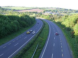
, the highest category of road is a Motorway (mótarbhealach, plural: mótarbhealaí), indicated by the prefix M followed by one or two digits. The Motorway network predominantly consists of two-lane dual carriageway
Dual carriageway
A dual carriageway is a class of highway with two carriageways for traffic travelling in opposite directions separated by a central reservation...
s primarily focused around Dublin, although a few Motorways contain three lanes and the M50
M50 motorway (Ireland)
The M50 motorway is a motorway in Ireland running in a C-shaped ring around the north-eastern, northern, western and southern sides of the capital city, Dublin. The northern end of the route is located at the entrance to the Dublin Port Tunnel. Anti-clockwise it heads northwest through the tunnel...
has four lanes at a number of points throughout its length.
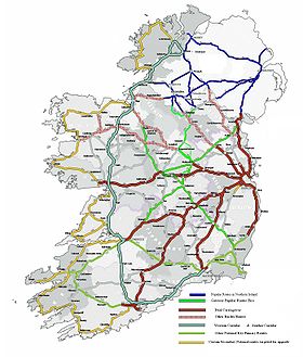
Completion of the Major Inter Urban route Motorway development project in December 2010 which connected Dublin completely by motorway to the cities of Cork, Limerick, Waterford & Galway, as well as other projects, has increased the total motorway network in the state to approximately 1017 kilometres (631.9 mi). Planned new road construction will possibly lead to almost 1100 kilometres (683.5 mi) of motorway by 2015, but these plans are not funded.
Regulations
Motorways in Ireland have a set of restrictions, which prohibit certain traffic from using the road. The following classes of traffic are not allowed on Irish motorways:- Learner drivers
- Slow vehicles (less than 50 km/h or 31 mph)
- Invalid carriages
- Pedestrians
- Pedal-cycles
- Vehicles under 50cc
- Vehicles without pneumatic tyres
- Animals
Rules for driving on motorways include the following:
- The keep left rule applies unless overtaking
- No stopping at any time
- No reversing
- No hitchhiking
- Only vehicles that can travel faster than 80 km/h (50 mph) may use the outside lane
- You may not drive on the hard-shoulder
The general motorway speed limit is 120 km/h (75 mph)
Specification
For more on motorway specification in general, view this motorway article.Motorways in Ireland are generally constructed to high-quality dual carriageway
High-quality dual carriageway
A High-quality dual carriageway is a category of road in the Republic of Ireland. It is an all-purpose dual carriageway road type built to near motorway standards, but without motorway classification or motorway restrictions. High-quality dual carriageways have full grade-separated access and do...
standard - with sightlines, curves and elevation designed for 120 km/h speeds. Until recently, all motorways were built with wide medians in the centre, which typically have a wire or steel barrier. The more recent schemes have narrow medians, only 3 metres in width, with a concrete barrier
Concrete step barrier
A concrete step barrier is a safety barrier used on the central reservation of motorways and dual carriageways as an alternative to the standard steel crash barrier.The barrier has contained all vehicles up to 13.5 tonnes.-United Kingdom:...
in the middle. These narrow-median schemes also have reduced carriageway width - a typical narrow-median motorway cross section has two 3.5 metre running lanes, a 2.5 metre hard shoulder and a 1.5 metre central reserve in each direction where as a typical wide median motorway has 3.75 metre running lanes and a 3 metre hard shoulder. Ireland has only a small amount of D3M (motorway with three lanes in each direction). The M50
M50 motorway (Ireland)
The M50 motorway is a motorway in Ireland running in a C-shaped ring around the north-eastern, northern, western and southern sides of the capital city, Dublin. The northern end of the route is located at the entrance to the Dublin Port Tunnel. Anti-clockwise it heads northwest through the tunnel...
is the most notable example, having been upgraded in parts from a two-lane motorway, to a three or four lane motorway in each direction.
Apart from terminal junctions, motorways can only be accessed using grade-separated junctions. These typically take the form of roundabout interchange
Roundabout interchange
A roundabout interchange is a type of interchange between a controlled access highway such as a motorway or freeway, and a minor road, in which the slip roads to and from the motorway carriageways converge at a single roundabout, which is grade-separated from the motorway lanes with bridges...
s for higher-capacity junctions, or dumbbell interchanges - which are a variant on the diamond-style interchange.
Diamond interchange
A diamond interchange is a common type of road junction, used where a freeway crosses a minor road. The freeway itself is grade-separated from the minor road, one crossing the other over a bridge...
- for lower-trafficked interchanges. A number of other types of junction are also used on the Republic's motorway network. The M4/M6 and M7/M9 junctions use a variant of the trumpet-style interchange while the M50/N7 and M50/N4 interchanges use partial cloverleaf junctions.
Safety
Motorways in Ireland include several safety features not found on other classes of road. The most notable include the presence of a continuous hard-shoulderShoulder (road)
A hard shoulder, or simply shoulder, is a reserved area by the verge of a road or motorway. Generally it is kept clear of motor vehicle traffic...
, use of crash barriers, superior lighting and provision of emergency phones at regular intervals. Some motorway schemes include deflectors to provide protection at interchanges.
Signage
Motorway signage in Ireland is blue, and is similar in design to UK signage. Route numbers use the Motorway font, and text uses an Irish variant of the Transport MediumTransport (typeface)
Transport is a sans serif typeface designed for road signs in the United Kingdom. It was created between 1957 and 1963 by Jock Kinneir and Margaret Calvert as part of their work as designers for the Department of Transport's Anderson and Worboys committees....
typeface (officially described as italic
Italic type
In typography, italic type is a cursive typeface based on a stylized form of calligraphic handwriting. Owing to the influence from calligraphy, such typefaces often slant slightly to the right. Different glyph shapes from roman type are also usually used—another influence from calligraphy...
, but more correctly oblique
Oblique type
Oblique type is a form of type that slants slightly to the right, used in the same manner as italic type. Unlike italic type, however, it does not use different glyph shapes; it uses the same glyphs as roman type, except distorted...
).
Route Number Inheritance
In the Republic of Ireland all motorways form part of a national route. The M50 was the only motorway that initially did not part of an existing national primary route, though it was designated as the national primary route N50 in 1994.In most cases, motorways have been built as a by-pass of a road previously forming the national road (e.g. M7 by-passing roads previously forming the N7). The by-passed roads are then generally reclassified as regional roads. Under Irish legislation (the Roads Act 1993), motorways are sections of roads with special regulations and they are signposted with the M prefix to indicate that they are under motorway regulations.
Present Network
The following table shows a list of motorways currently open in the Republic of Ireland.| Route | Motorway section | Destinations | Toll |
|---|---|---|---|
 |
Dublin to north of Dundalk Dundalk Dundalk is the county town of County Louth in Ireland. It is situated where the Castletown River flows into Dundalk Bay. The town is close to the border with Northern Ireland and equi-distant from Dublin and Belfast. The town's name, which was historically written as Dundalgan, has associations... (Border with Northern Ireland Northern Ireland Northern Ireland is one of the four countries of the United Kingdom. Situated in the north-east of the island of Ireland, it shares a border with the Republic of Ireland to the south and west... ). |
Dublin – Belfast Belfast Belfast is the capital of and largest city in Northern Ireland. By population, it is the 14th biggest city in the United Kingdom and second biggest on the island of Ireland . It is the seat of the devolved government and legislative Northern Ireland Assembly... / (Derry Derry Derry or Londonderry is the second-biggest city in Northern Ireland and the fourth-biggest city on the island of Ireland. The name Derry is an anglicisation of the Irish name Doire or Doire Cholmcille meaning "oak-wood of Colmcille"... ) |
Yes |
 |
Killshane to north of Ashbourne Ashbourne, County Meath Ashbourne, historically called Killeglan or Kildeglan , is a town in County Meath, Ireland. It is about 20 km north of Dublin city centre and is bypassed by the M2 motorway.-History:... . |
Dublin – Derry Derry Derry or Londonderry is the second-biggest city in Northern Ireland and the fourth-biggest city on the island of Ireland. The name Derry is an anglicisation of the Irish name Doire or Doire Cholmcille meaning "oak-wood of Colmcille"... |
No |
 |
Dublin to north of Kells. | Dublin – Donegal Donegal Donegal or Donegal Town is a town in County Donegal, Ireland. Its name, which was historically written in English as Dunnagall or Dunagall, translates from Irish as "stronghold of the foreigners" .... |
Yes |
 |
Lucan to Mullingar Mullingar Mullingar is the county town of County Westmeath in Ireland. The Counties of Meath and Westmeath Act of 1542, proclaimed Westmeath a county, separating it from Meath. Mullingar became the administrative centre for County Westmeath... . |
Dublin – Sligo Sligo Sligo is the county town of County Sligo in Ireland. The town is a borough and has a charter and a town mayor. It is sometimes referred to as a city, and sometimes as a town, and is the second largest urban area in Connacht... |
Yes |
 |
Kinnegad Kinnegad Kinnegad or Kinagad is a town in County Westmeath, Ireland. It is near the border with County Meath, at the junction of the N6 and the N4 - two of Ireland's main east-west roads... to east of Athlone, west of Athlone to Galway Galway Galway or City of Galway is a city in County Galway, Republic of Ireland. It is the sixth largest and the fastest-growing city in Ireland. It is also the third largest city within the Republic and the only city in the Province of Connacht. Located on the west coast of Ireland, it sits on the... |
Dublin – Galway Galway Galway or City of Galway is a city in County Galway, Republic of Ireland. It is the sixth largest and the fastest-growing city in Ireland. It is also the third largest city within the Republic and the only city in the Province of Connacht. Located on the west coast of Ireland, it sits on the... |
Yes |
 |
Naas Naas Naas is the county town of County Kildare in Ireland. With a population of just over twenty thousand, it is also the largest town in the county. Naas is a major commuter suburb, with many people residing there and working in Dublin... to Limerick Limerick Limerick is the third largest city in the Republic of Ireland, and the principal city of County Limerick and Ireland's Mid-West Region. It is the fifth most populous city in all of Ireland. When taking the extra-municipal suburbs into account, Limerick is the third largest conurbation in the... . |
Dublin – Limerick Limerick Limerick is the third largest city in the Republic of Ireland, and the principal city of County Limerick and Ireland's Mid-West Region. It is the fifth most populous city in all of Ireland. When taking the extra-municipal suburbs into account, Limerick is the third largest conurbation in the... / (Cork Cork (city) Cork is the second largest city in the Republic of Ireland and the island of Ireland's third most populous city. It is the principal city and administrative centre of County Cork and the largest city in the province of Munster. Cork has a population of 119,418, while the addition of the suburban... ) / (Tralee) |
Yes |
 |
Entire route. | Dublin – Cork Cork (city) Cork is the second largest city in the Republic of Ireland and the island of Ireland's third most populous city. It is the principal city and administrative centre of County Cork and the largest city in the province of Munster. Cork has a population of 119,418, while the addition of the suburban... |
Yes (Junctions 14 through 17) |
 |
Entire route. | Dublin – Waterford Waterford Waterford is a city in the South-East Region of Ireland. It is the oldest city in the country and fifth largest by population. Waterford City Council is the local government authority for the city and its immediate hinterland... |
No |
 |
Shankill/Bray Bray Bray is a town in north County Wicklow, Ireland. It is a busy urban centre and seaside resort, with a population of 31,901 making it the fourth largest in Ireland as of the 2006 census... Bypass, Ashford Ashford, County Wicklow Ashford , historically known as Ballymacahara , is a village County Wicklow, Republic of Ireland. It lies on the R772 regional road. The Vartry River flows under the road in the village centre... /Rathnew Rathnew Rathnew is a village of County Wicklow, Ireland. Located south of the capital Dublin along the N11 between Dublin and Wexford, it is the exit point for those wishing to visit the county town of Wicklow, situated to the East.-Education:... Bypass, Arklow Arklow Arklow , also known as Inbhear Dé from the Avonmore river's older name Abhainn Dé, is a historic town located in County Wicklow on the east coast of Ireland. Founded by the Vikings in the ninth century, Arklow was the site of one of the bloodiest battles of the 1798 rebellion... /Gorey Gorey Gorey , is a market town in north County Wexford, Ireland, situated beside the main M11 Dublin to Wexford road. The town is also connected to the railway network along the same route. Local newspapers include the Gorey Guardian and Gorey Echo.... Bypass. |
Dublin – Wexford Wexford Wexford is the county town of County Wexford, Ireland. It is situated near the southeastern corner of Ireland, close to Rosslare Europort. The town is connected to Dublin via the M11/N11 National Primary Route, and the national rail network... |
No |
 |
Shannon Shannon, County Clare Shannon or Shannon Town , named after the river near which it stands, is a town located in County Clare. It was given town status on 1 January 1982. The town is located just off the N19 road, a spur of the N18/M18 road between Limerick city and Ennis.... , Co. Clare to north of Gort Gort Gort is a town in south County Galway in the west of Ireland. An Gort is the official Irish name for the town, as defined by the Placenames Commission. In spoken Irish, however, the town is known by its traditional name Gort Inse Guaire. It lies just north of the border with County Clare on the... . |
Limerick Limerick Limerick is the third largest city in the Republic of Ireland, and the principal city of County Limerick and Ireland's Mid-West Region. It is the fifth most populous city in all of Ireland. When taking the extra-municipal suburbs into account, Limerick is the third largest conurbation in the... – Galway Galway Galway or City of Galway is a city in County Galway, Republic of Ireland. It is the sixth largest and the fastest-growing city in Ireland. It is also the third largest city within the Republic and the only city in the Province of Connacht. Located on the west coast of Ireland, it sits on the... |
No |
 |
Outskirts of Limerick Limerick Limerick is the third largest city in the Republic of Ireland, and the principal city of County Limerick and Ireland's Mid-West Region. It is the fifth most populous city in all of Ireland. When taking the extra-municipal suburbs into account, Limerick is the third largest conurbation in the... City to Patrickswell Patrickswell Patrickswell, historically known as Toberpatrick , is a small town in County Limerick, Ireland.-Etymology:The name refers to St. Patrick and there is a small hand pump/well in the main street; Microsoft mappoint and some other programs call the village St. Patrick's Well or St.... , (Remainder to Cork Planned) |
Limerick Limerick Limerick is the third largest city in the Republic of Ireland, and the principal city of County Limerick and Ireland's Mid-West Region. It is the fifth most populous city in all of Ireland. When taking the extra-municipal suburbs into account, Limerick is the third largest conurbation in the... – Cork Cork (city) Cork is the second largest city in the Republic of Ireland and the island of Ireland's third most populous city. It is the principal city and administrative centre of County Cork and the largest city in the province of Munster. Cork has a population of 119,418, while the addition of the suburban... |
No |
 |
Entire route. | Dublin ring road Ring road A ring road, orbital motorway, beltway, circumferential highway, or loop highway is a road that encircles a town or city... |
Yes (West-Link West-Link The West-Link is a toll bridge on the M50 motorway to the west of Dublin, Ireland, operated by BetEire Flow Limited for the National Roads Authority.- Structure :... and Dublin Port Tunnel Dublin Port Tunnel The Dublin Port Tunnel is a road traffic tunnel in Dublin, Ireland, that forms part of the M50 motorway.... only) |
1983-1989
In 1983, the first sections of Irish motorway were opened: a short section of M7 bypassing NaasNaas
Naas is the county town of County Kildare in Ireland. With a population of just over twenty thousand, it is also the largest town in the county. Naas is a major commuter suburb, with many people residing there and working in Dublin...
and the first stretch of M1 (part of which has now been redesignated M50). The M1 was later extended in 1985 to Dublin Airport
Dublin Airport
Dublin Airport, , is operated by the Dublin Airport Authority. Located in Collinstown, in the Fingal part of County Dublin, 18.4 million passengers passed through the airport in 2010, making it the busiest airport in the Republic of Ireland, followed by Cork and Shannon...
.
1990-1999
Ireland's motorway network began to expand significantly between 1990 and 1999. The first of the projects completed in this period was the western section of the M50, linking the N7, N4 and N3 together in 1990. This was quickly followed by the M11 Bray/Shankhill bypass in 1991. After this there followed a lull in construction after what had been a busy few years in motorway construction by then Irish road building standards. 1993 saw an extension to the M7, continuing from the Naas Bypass and providing a bypass of the town of Newbridge, as well as the M9 Kilcullen spur. In addition, another small section of M1, a bypass of Dunleer in Co. Louth was opened. The Leixlip to Kilcock motorway was completed in 1994, forming part of the M4. In 1995 there were no new motorways opened and in 1996 only the northern section of the M50 was opened, linking the existing motorway to the N2 and M1. The Portlaoise bypass opened as M7 in 1997 and like the M1 Dunleer bypass, seemed very isolated compared to the rest of the network which was concentrated around Dublin. 1998 featured the opening of another short piece of M1, this time to the south of Balbriggan, modern day junctions 5 and 6. In 1999 however, there were no new sections of motorway opened.2000-2010
The first decade of the twenty-first century saw a major expansion in the construction of new motorways in Ireland, after an initially slow start. There were no new motorways opened in 2000 but another section of the M1, extending the Dunleer bypass northwards to the south of DundalkDundalk
Dundalk is the county town of County Louth in Ireland. It is situated where the Castletown River flows into Dundalk Bay. The town is close to the border with Northern Ireland and equi-distant from Dublin and Belfast. The town's name, which was historically written as Dundalgan, has associations...
(junction 16), was opened in 2001. Continuing the quiet period, 2002 also saw no new motorway in Ireland, but 2003 was a big year. Finally the various sections of M1 were joined together, creating continuous motorway from Dublin to just south of Dundalk. A key part of this route was the Drogheda
Drogheda
Drogheda is an industrial and port town in County Louth on the east coast of Ireland, 56 km north of Dublin. It is the last bridging point on the River Boyne before it enters the Irish Sea....
bypass which was tolled. Also in 2003, the M7 was extended westwards from Newbridge
Newbridge
-Ireland:*Newbridge, County Kildare — sometimes known by its Irish name, Droichead Nua*Newbridge, County Galway*Newbridge, County Londonderry, Northern Ireland-United Kingdom:*Newbridge, Bath, electoral ward...
to also bypass Kildare (up to modern day junction 13). A year later and this had been extended further so that both sections of M7 were joined. This provided continuous motorway from Naas
Naas
Naas is the county town of County Kildare in Ireland. With a population of just over twenty thousand, it is also the largest town in the county. Naas is a major commuter suburb, with many people residing there and working in Dublin...
to Portlaoise.
By 2005, projects were beginning to be completed faster and in this year the M4 was extended from Kilcock
Kilcock
Kilcock or Killcock is a town and townland in the north of County Kildare, Ireland, on the border with County Meath. Kilcock is a dormitory town for many of those who work in Dublin...
to Kinnegad
Kinnegad
Kinnegad or Kinagad is a town in County Westmeath, Ireland. It is near the border with County Meath, at the junction of the N6 and the N4 - two of Ireland's main east-west roads...
, this section of motorway having a toll applied to it, one of the first PPP schemes to be trialled in Ireland. The M1 Dundalk bypass was also finished, meaning that there was now a full motorway link on the Dublin to Belfast route virtually as far as the border. Finally in 2005, the M50 was extended to link up to the M11, providing a full western bypass of the capital. In 2006, the M8 Fermoy
Fermoy
Fermoy is a town in County Cork, Ireland. It is situated on the River Blackwater in the south of Ireland. Its population is some 5,800 inhabitants, environs included ....
to Watergrasshill
Watergrasshill
Watergrasshill is a small town in County Cork, Province of Munster, Ireland. The 2006 census recorded a population of 1,068.Bypassed in 2003, the town is situated on the R639 road. It is accessible via junction 17 of the M8 motorway...
motorway was opened, another section that was tolled. Also a section of what would become M6 was completed, going westwards from the M4 at Kinnegad to Tyrellspass, the road was opened as N6 and was the first section of road to be completed that would be affected by the Roads Act 2007 and motorway redesignation. In 2007 the same road was extended by some 10 km to join with the N52 north of Tullamore
Tullamore
Tullamore is a town in County Offaly, in the midlands of Ireland. It is Offaly's county town and the centre of the district.Tullamore is an important commercial and industrial centre in the region. Major international employers in the town include 'Tyco Healthcare' and 'Boston Scientific'. In...
, still opened as N6 as the first tranche of motorway redesignations had only just been submitted.
2008 was one of the most important years for Irish motorways, with a large section of M8 opened, making it the longest motorway in the country. Stretching from Urlingford
Urlingford
Urlingford is a town in the barony of Galmoy, County Kilkenny, Ireland.The town lies on the R639. The M8 motorway runs just west of the town, from which both Urlingford and nearby Johnstown are accessed via junction four. Urlingford is a bus hub, with major operator JJ Kavanagh and Sons based there...
to just east of Mitchelstown
Mitchelstown
Mitchelstown is a town in County Cork, Ireland with a population of approximately 3300. Mitchelstown is situated in the valley to the south of the Galtee Mountains close to the Mitchelstown Caves and is 28 km from Cahir, 50 km from Cork and 59 km from Limerick...
, the motorway opened in various sections, the first being the Cashel
Cashel, County Tipperary
Cashel is a town in South Tipperary in Ireland. Its population was 2936 at the 2006 census. The town gives its name to the ecclesiastical province of Cashel. Additionally, the cathedra of the Roman Catholic Archdiocese of Cashel and Emly was originally in the town prior to the English Reformation....
bypass, which opened in 2004, and which was followed by the Cashel to Mitchelstown section, both of which were open before the redesignation to motorway came into effect on 24 September 2008. The Urlingford to Cashel section opened later on in the year and so became motorway immediately. Also opened in 2008 was the M9 Carlow
Carlow
Carlow is the county town of County Carlow in Ireland. It is situated in the south-east of Ireland, 84 km from Dublin. County Carlow is the second smallest county in Ireland by area, however Carlow Town is the 14th largest urban area in Ireland by population according to the 2006 census. The...
bypass which was also open to traffic before the redesignation came into effect. Finally, the M6 was extended to the Athlone bypass and Ireland's motorway network was greatly expanded.
2009 was another major milestone in the development of the Irish motorway network, with many projects under construction finished by the end of the year. Redesignation of High-Quality Dual-Carriageway sections of National Primary routes to motorway took effect on 28 August 2009, further expanding the network. On the 18th of December 2009 the M6 was opened (Dublin-Galway direct)it is 194 km of motorway. The M9 (linking Dublin to Carlow) was opened on Monday the 21st of December 2009 and was expanded in March 2010 to link Dublin to Waterford directly. The M9 was fully completed with the opening of the Carlow to Knocktopher section on the 9th of September 2010.
2010:
M3: 61 km of motorway in Co. Meath opened on June 4, 2010.
M7: Nenagh - Limerick, 38 km long, opened in three stages, being fully opened on September 28, 2010.
M7: Limerick - Shannon motorway tunnel, 10 km long, opened ahead of schedule on July 27, 2010.
M7: Castletown - Nenagh, 36 km long, opened 22 December 2010.
M7/M8: Portlaoise - Castletown, Portlaoise to Cullahill, 40 km, opened on May 28, 2010.
M9: Carlow - Knocktopher, 40 km long, opened September 9, 2010.
M9: Knocktopher - Waterford, 24 km long, opened March 22, 2010.
M50: improvements for Dublin, completed August 2010, but expected earlier.
M18: Crusheen and Gort, 22 km, opened November 12, 2010.
Motorway Redesignation (Tranche 1)
The Roads Act 2007 was passed into law in mid-2007. This Act makes provision for the redesignation of suitable dual carriageways to motorway status. The National Roads Authority made formal applications under Section 8 of the Act to the Minister for Transport on 16 October 2007 regarding dual carriageways which the authority believed to be suitable for redesignation as motorways.On 29 January 2008, the Department of Transport published notice of the Minister's intention to make the orders being sought and invited submissions or observations to be made to the Minister regarding the NRA's applications.
The consultation procession lasted until 28 March 2008. On 17 July 2008 the statutory instrument
Statutory Instrument
A Statutory Instrument is the principal form in which delegated or secondary legislation is made in Great Britain.Statutory Instruments are governed by the Statutory Instruments Act 1946. They replaced Statutory Rules and Orders, made under the Rules Publication Act 1893, in 1948.Most delegated...
redesignating the roads as motorways was signed, and any open parts of these roads have officially become motorways as of 24 September 2008. The Carlow bypass and Kilbeggan-Athlone roads opened with motorway signage but with temporary 100 km/h general speed limits between their opening and their official re-designation as motorways.
The following sections were redesignated:
| Route | Proposed motorway section | Destinations |
|---|---|---|
| N6 road | Kinnegad (M6 J2) – Athlone | (Dublin) – Galway Galway Galway or City of Galway is a city in County Galway, Republic of Ireland. It is the sixth largest and the fastest-growing city in Ireland. It is also the third largest city within the Republic and the only city in the Province of Connacht. Located on the west coast of Ireland, it sits on the... |
| N7 road | South of Borris-in-Ossory Borris-in-Ossory Borris-in-Ossory is a village in west County Laois, Ireland. Bypassed by the M7 motorway on 28 May, 2010, the village is situated on the R445 road close to the County Tipperary border between the towns of Mountrath and Roscrea.-Features:... to Annacotty Annacotty Annacotty is a town on the outskirts of Limerick, Ireland, from the centre of the city. It is situated where the old N7 main road between Limerick and Dublin crosses the Mulkear River, upstream of where it flows into the River Shannon.... |
Dublin – Limerick Limerick Limerick is the third largest city in the Republic of Ireland, and the principal city of County Limerick and Ireland's Mid-West Region. It is the fifth most populous city in all of Ireland. When taking the extra-municipal suburbs into account, Limerick is the third largest conurbation in the... |
| N8 road | Urlingford Urlingford Urlingford is a town in the barony of Galmoy, County Kilkenny, Ireland.The town lies on the R639. The M8 motorway runs just west of the town, from which both Urlingford and nearby Johnstown are accessed via junction four. Urlingford is a bus hub, with major operator JJ Kavanagh and Sons based there... – Fermoy Fermoy Fermoy is a town in County Cork, Ireland. It is situated on the River Blackwater in the south of Ireland. Its population is some 5,800 inhabitants, environs included .... |
(Dublin) – Cork Cork (city) Cork is the second largest city in the Republic of Ireland and the island of Ireland's third most populous city. It is the principal city and administrative centre of County Cork and the largest city in the province of Munster. Cork has a population of 119,418, while the addition of the suburban... |
| N9 road | Kilcullen Kilcullen Kilcullen , formally Kilcullen Bridge, is a small town on the River Liffey in County Kildare, Ireland. Its population of 2,985 makes it the 12th largest settlement in County Kildare and the fastest growing in the county, having doubled in population from 1,483 in the census of 2002... – Powerstown ) |
(Dublin) – Waterford Waterford Waterford is a city in the South-East Region of Ireland. It is the oldest city in the country and fifth largest by population. Waterford City Council is the local government authority for the city and its immediate hinterland... |
Motorway Redesignation (Tranche 2)
Statutory Instrument
A Statutory Instrument is the principal form in which delegated or secondary legislation is made in Great Britain.Statutory Instruments are governed by the Statutory Instruments Act 1946. They replaced Statutory Rules and Orders, made under the Rules Publication Act 1893, in 1948.Most delegated...
reclassifying the roads as motorways was made on 2 July 2009, taking effect from 28 August 2009
The following schemes were included:
| Route | Proposed motorway section | Destinations |
|---|---|---|
| N2 road | Junction 2 – north of Ashbourne | Dublin – Derry Derry Derry or Londonderry is the second-biggest city in Northern Ireland and the fourth-biggest city on the island of Ireland. The name Derry is an anglicisation of the Irish name Doire or Doire Cholmcille meaning "oak-wood of Colmcille"... |
| N3 road | Mulhuddart Mulhuddart Mulhuddart is a suburb situated to the north-west of Dublin city, in the barony of Castleknock, Ireland. The River Tolka passes near the village.-Location and access:The N3 dual carriageway now by-passes the village... – Dunboyne Dunboyne Dunboyne is a town in County Meath in Ireland. For the most part, it is a dormitory town for the city of Dublin.-Location:Dunboyne is centred on the crossroads formed by the R156 regional road and the old Maynooth Road .... |
Dublin – Ballyshannon Ballyshannon Ballyshannon is a town in County Donegal, Ireland. It is located where the N3 and N15 cross the River Erne, and claims to be the oldest town in Ireland.-Location:... |
| N4 road | Kinnegad Kinnegad Kinnegad or Kinagad is a town in County Westmeath, Ireland. It is near the border with County Meath, at the junction of the N6 and the N4 - two of Ireland's main east-west roads... – McNead's Bridge |
Dublin – Sligo Sligo Sligo is the county town of County Sligo in Ireland. The town is a borough and has a charter and a town mayor. It is sometimes referred to as a city, and sometimes as a town, and is the second largest urban area in Connacht... |
| N6 road | West of Athlone – Galway Galway Galway or City of Galway is a city in County Galway, Republic of Ireland. It is the sixth largest and the fastest-growing city in Ireland. It is also the third largest city within the Republic and the only city in the Province of Connacht. Located on the west coast of Ireland, it sits on the... |
(Dublin) – Galway Galway Galway or City of Galway is a city in County Galway, Republic of Ireland. It is the sixth largest and the fastest-growing city in Ireland. It is also the third largest city within the Republic and the only city in the Province of Connacht. Located on the west coast of Ireland, it sits on the... |
| N7 road | Annacotty Annacotty Annacotty is a town on the outskirts of Limerick, Ireland, from the centre of the city. It is situated where the old N7 main road between Limerick and Dublin crosses the Mulkear River, upstream of where it flows into the River Shannon.... – Limerick Limerick Limerick is the third largest city in the Republic of Ireland, and the principal city of County Limerick and Ireland's Mid-West Region. It is the fifth most populous city in all of Ireland. When taking the extra-municipal suburbs into account, Limerick is the third largest conurbation in the... |
Dublin – Limerick Limerick Limerick is the third largest city in the Republic of Ireland, and the principal city of County Limerick and Ireland's Mid-West Region. It is the fifth most populous city in all of Ireland. When taking the extra-municipal suburbs into account, Limerick is the third largest conurbation in the... |
| N8 road | Watergrasshill Watergrasshill Watergrasshill is a small town in County Cork, Province of Munster, Ireland. The 2006 census recorded a population of 1,068.Bypassed in 2003, the town is situated on the R639 road. It is accessible via junction 17 of the M8 motorway... – Cork Cork (city) Cork is the second largest city in the Republic of Ireland and the island of Ireland's third most populous city. It is the principal city and administrative centre of County Cork and the largest city in the province of Munster. Cork has a population of 119,418, while the addition of the suburban... |
(Dublin) – Cork Cork (city) Cork is the second largest city in the Republic of Ireland and the island of Ireland's third most populous city. It is the principal city and administrative centre of County Cork and the largest city in the province of Munster. Cork has a population of 119,418, while the addition of the suburban... |
| N11 road | Ashford Ashford, County Wicklow Ashford , historically known as Ballymacahara , is a village County Wicklow, Republic of Ireland. It lies on the R772 regional road. The Vartry River flows under the road in the village centre... – Rathnew Rathnew Rathnew is a village of County Wicklow, Ireland. Located south of the capital Dublin along the N11 between Dublin and Wexford, it is the exit point for those wishing to visit the county town of Wicklow, situated to the East.-Education:... and Arklow Arklow Arklow , also known as Inbhear Dé from the Avonmore river's older name Abhainn Dé, is a historic town located in County Wicklow on the east coast of Ireland. Founded by the Vikings in the ninth century, Arklow was the site of one of the bloodiest battles of the 1798 rebellion... – Gorey Gorey Gorey , is a market town in north County Wexford, Ireland, situated beside the main M11 Dublin to Wexford road. The town is also connected to the railway network along the same route. Local newspapers include the Gorey Guardian and Gorey Echo.... |
(Dublin) – Wexford Wexford Wexford is the county town of County Wexford, Ireland. It is situated near the southeastern corner of Ireland, close to Rosslare Europort. The town is connected to Dublin via the M11/N11 National Primary Route, and the national rail network... |
| N18 road | Shannon Shannon, County Clare Shannon or Shannon Town , named after the river near which it stands, is a town located in County Clare. It was given town status on 1 January 1982. The town is located just off the N19 road, a spur of the N18/M18 road between Limerick city and Ennis.... – Athenry Athenry Athenry is a town in County Galway, Ireland. It lies east of Galway city, and one of the attractions of the town is its medieval castle. The town is also well-known by virtue of the song "The Fields of Athenry".-History:... |
Limerick Limerick Limerick is the third largest city in the Republic of Ireland, and the principal city of County Limerick and Ireland's Mid-West Region. It is the fifth most populous city in all of Ireland. When taking the extra-municipal suburbs into account, Limerick is the third largest conurbation in the... – Galway Galway Galway or City of Galway is a city in County Galway, Republic of Ireland. It is the sixth largest and the fastest-growing city in Ireland. It is also the third largest city within the Republic and the only city in the Province of Connacht. Located on the west coast of Ireland, it sits on the... |
| N20 road | Limerick Limerick Limerick is the third largest city in the Republic of Ireland, and the principal city of County Limerick and Ireland's Mid-West Region. It is the fifth most populous city in all of Ireland. When taking the extra-municipal suburbs into account, Limerick is the third largest conurbation in the... – Patrickswell Patrickswell Patrickswell, historically known as Toberpatrick , is a small town in County Limerick, Ireland.-Etymology:The name refers to St. Patrick and there is a small hand pump/well in the main street; Microsoft mappoint and some other programs call the village St. Patrick's Well or St.... |
Limerick Limerick Limerick is the third largest city in the Republic of Ireland, and the principal city of County Limerick and Ireland's Mid-West Region. It is the fifth most populous city in all of Ireland. When taking the extra-municipal suburbs into account, Limerick is the third largest conurbation in the... – Cork Cork (city) Cork is the second largest city in the Republic of Ireland and the island of Ireland's third most populous city. It is the principal city and administrative centre of County Cork and the largest city in the province of Munster. Cork has a population of 119,418, while the addition of the suburban... |
On the N6, the Athlone bypass had also been included in the proposed redesignations. However, the final order (the Roads Act 2007 (Declaration of Motorways) Order 2009) did not include this section. However, the section of the N9 road between Powerstown and Waterford
Waterford
Waterford is a city in the South-East Region of Ireland. It is the oldest city in the country and fifth largest by population. Waterford City Council is the local government authority for the city and its immediate hinterland...
, which had been proposed as part of the first tranche but not included in the final order, was included in this order.
Inter-urban motorways
Linking Dublin to regional cities. These motorways are:- M1M1 motorway (Ireland)M1 motorway may refer to:*M1 motorway *M1 motorway...
- linking Dublin with border (Belfast) - M6M6 motorway (Ireland)The M6 motorway is a motorway in Ireland, which runs from Dublin to Galway. The M6 extends from its junction with the M4 at Kinnegad all the way west to the outskirts of Galway City, but the Athlone bypass and the approach to Galway city - while of dual carriageway standard - have not been...
- linking Dublin with Galway (Officially opened, 18 December 2009 and was the first city to city motorway in Ireland) - M7 - linking Dublin with Limerick
- M8M8 motorway (Ireland)The M8 motorway is an inter-urban motorway in Ireland, which forms part of the road from the capital - Dublin - to Cork city. The 149 km motorway commences in the townland of Aghaboe, County Laois and runs through the counties of Kilkenny, North Tipperary, South Tipperary and Limerick,...
- linking Dublin with Cork - M9M9 motorway (Ireland)The M9 motorway is a motorway in Ireland linking the M7 at Kilcullen to Waterford. Opened in sections between 1994 and 2010, the final section opened on 9 September 2010....
- linking Dublin with Waterford (completed September 9, 2010)
As of the end of 2010, all sections of these motorways are completed. The completion of these schemes has added more than 300 km of motorway to the current network.
Atlantic Corridor
Under the government's Transport 21Transport 21
Transport 21 is an Irish infrastructure plan, announced in November 2005. It aims to greatly expand Ireland's transport network. A cost estimate of €34 billion was attached to the plan at the time....
iniative, Letterkenny
Letterkenny
Letterkenny , with a population of 17,568, is the largest town in County Donegal, part of the Province of Ulster in Ireland. The town is located on the River Swilly...
will be linked to Waterford
Waterford
Waterford is a city in the South-East Region of Ireland. It is the oldest city in the country and fifth largest by population. Waterford City Council is the local government authority for the city and its immediate hinterland...
and Cork with new high quality roads - collectively known as the "Atlantic Corridor
Atlantic Corridor
The Atlantic Corridor is a road project in Ireland that eventually will link Waterford in the South-East to Letterkenny in the North-West by high-quality dual carriageway or motorway. A major infrastructure project, the scheme was announced as part of the Transport 21 project launch in 2005, and is...
". While it is anticipated much of this scheme will be constructed as either 2+2 dual carriageway or higher quality single-carriageway - a significant portion of it is expected to be constructed as motorway.
- The M20 scheme linking Cork with Limerick, will provide a complete connection between the two cities. It will be approximately 90 km in length. It is being progressed as a PPP.
- The M18M18 motorway (Ireland)The M18 motorway is an inter-urban motorway in Ireland, forming part of the Limerick, Ennis to Galway national primary road, which, in turn, forms part of the Atlantic Corridor called for as part of the Transport 21 project.-Route:...
scheme linking Ennis with Galway will provide a high quality link between Galway, Ennis and Limerick. It will be approximately 70 km in length when complete. A significant proportion of this route is already complete (and has been redesignated to motorway standard - effective 28/8/09), with a 22 km section between Crusheen and Gort opened in November 2010.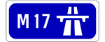
- The M17 scheme will link AthenryAthenryAthenry is a town in County Galway, Ireland. It lies east of Galway city, and one of the attractions of the town is its medieval castle. The town is also well-known by virtue of the song "The Fields of Athenry".-History:...
with TuamTuamTuam is a town in County Galway, Ireland. The name is pronounced choo-um . It is situated west of the midlands of Ireland, and north of Galway city.-History:...
. It will connect to the M6 and M18.
Other Motorways
Other motorway schemes are also being progressed at the moment. A motorway project, the Dublin Outer Orbital RouteOuter Orbital Route
The Outer Orbital Route is a proposed motorway that is to be built sometime between 2011 and 2019, around the city of Dublin, Ireland. It will serve as a second bypass of the city to complement the M50 road and will link all of Dublin's main trunk routes: M1, M2, M3, M4, and M7. The only route that...
, may be progressed in the future. It is possible that a motorway will be built to the north of Cork City to link the existing N22, N20 and M8
M8 motorway (Ireland)
The M8 motorway is an inter-urban motorway in Ireland, which forms part of the road from the capital - Dublin - to Cork city. The 149 km motorway commences in the townland of Aghaboe, County Laois and runs through the counties of Kilkenny, North Tipperary, South Tipperary and Limerick,...
routes: this route, if built, will most likely be designated as the M22. Other potential motorways include the planned M11 Enniscorthy
Enniscorthy
Enniscorthy is the second largest town in County Wexford, Ireland. The population of the town and environs is 9538. The Placenames Database of Ireland sheds no light on the origins of the town's name. It may refer either to the "Island of Corthaidh" or the "Island of Rocks". With a history going...
bypass, a possible extension of the M4 from Mullingar
Mullingar
Mullingar is the county town of County Westmeath in Ireland. The Counties of Meath and Westmeath Act of 1542, proclaimed Westmeath a county, separating it from Meath. Mullingar became the administrative centre for County Westmeath...
to Longford
Longford
Longford is the county town of County Longford in Ireland. It has a population of 7,622 according to the 2006 census. Approximately one third of the county's population resides in the town. Longford town is also the biggest town in the county...
and the Galway City Outer Bypass which may be built as an extension to the M6.
Motorway Service Areas
The NRA has proposed to build a series of service areasMotorway service area
In the UK motorway service areas, also known as service stations, are places where drivers can leave a motorway to refuel, rest, or take refreshments. The vast majority of motorway services in the UK are owned by one of three companies: Moto, Welcome Break and RoadChef. Extra are also developing a...
across the new motorway network to address the current critical lack of safe rest areas. The first of these opening 15 Sept 2010 on the M1 Motorway (Republic of Ireland) at Lusk
Lusk services
Lusk services is a 24 Hour Motorway service station; that is located just off the M1 motorway at junction 4. The service station was the first Motorway service station to open in Ireland.-Facilities:*Burger King*Child play area*Convenience Store...
.
Current service areas:
- M1 - LuskLusk servicesLusk services is a 24 Hour Motorway service station; that is located just off the M1 motorway at junction 4. The service station was the first Motorway service station to open in Ireland.-Facilities:*Burger King*Child play area*Convenience Store...
- M1 - Castlebellingham
- M4 - Enfield
- M8 - Cashel
The following sites have also been proposed:
- M6 - Athlone
- M7 - Mountrath
- M7 - Nenagh
- M8 - Kilworth
- M9 - Kilcullen
- M9 - Carlow
- M11 - Gorey
- M20 - Charleville
Originally, service areas were to be located at 12 locations, but a recent An Bord Pleanála
An Bord Pleanála
An Bord Pleanála is an independent statutory administrative tribunal that decides on appeals from planning decisions made by local authorities in the Republic of Ireland. As of 2007 The Planning Board directly decides major strategic infrastructural projects under the provisions of the Planning...
decision ruled that a service area to be located at Rathmorrissey at an M6 junction be removed from an adjacent scheme.
It is anticipated that service areas will be provided on both the M3 motorway and the proposed M20 motorway.
Predicted 2015 Network
| Motorway Number | Estimated/Actual Length | Corridor |
|---|---|---|
| M1 | 90.7 km | Dublin - Dundalk |
| M2 | 13 km | Dublin - Ashbourne |
| M3 | 51.4 km | Dublin - Kells |
| M4 | 61.9 km | Lucan - Mullingar |
| M6 | 144 km | Kinnegad - Galway |
| M7 | 185 km | Dublin - Limerick |
| M8 | 143 km | Portlaoise - Cork |
| M9 | 116.75 km | Naas -Waterford |
| M11 | 62.5 km | Dublin - Wexford |
| M17 | 25.5 km | Galway - Tuam |
| M18 | 70.8 km | Shannon - Galway |
| M20 | Approx. 90 km | Cork - Limerick |
| M50 | 49.25 km | Dublin Orbital |
| Total | 1,110 km | National motorway network. |
See also
- Roads in IrelandRoads in IrelandThe island of Ireland, comprising Northern Ireland and the Republic of Ireland, has an extensive network of tens of thousands of kilometres of public roads, usually surfaced. These roads have been developed and modernised over centuries, from trackways suitable only for walkers and horses, to...
- List of motorways in Northern Ireland
- National primary roadNational primary roadA national primary road is a road classification in the Republic of Ireland. National primary roads form the major routes between the major urban centres. There are over 2,700km of national primary roads. This category of road has the prefix "N" followed by one or two digits...
- National secondary roadNational secondary roadA national secondary road is a category of road in Ireland. These roads form an important part of the national route network, but are secondary to the main arterial routes which are classified as national primary roads. National secondary roads are designated with route numbers higher than those...
- Regional roadRegional roadA regional road in Ireland is a class of road not forming a major route , but nevertheless forming a link in the national route network. There are over 11,600 kilometres of regional roads. Regional roads are numbered with three digit route numbers, prefixed by "R" A regional road in Ireland is a...
- Local Roads in IrelandLocal Roads in IrelandA Local Road in Ireland is a class of public road not classified as a National road or as a Regional road but nevertheless forming a link in the national network of roads...
- Atlantic CorridorAtlantic CorridorThe Atlantic Corridor is a road project in Ireland that eventually will link Waterford in the South-East to Letterkenny in the North-West by high-quality dual carriageway or motorway. A major infrastructure project, the scheme was announced as part of the Transport 21 project launch in 2005, and is...
- Dublin Port TunnelDublin Port TunnelThe Dublin Port Tunnel is a road traffic tunnel in Dublin, Ireland, that forms part of the M50 motorway....
- Jack Lynch TunnelJack Lynch TunnelThe Jack Lynch Tunnel is an immersed tube tunnel and an integral part of the N25 southern ring road of Cork in Ireland. It is named after former Taoiseach, Jack Lynch, a native of Cork....
- History of Roads in IrelandHistory of Roads in IrelandThere have been routes and trackways in Ireland connecting settlements and facilitating trade since ancient times and the country now has an extensive network of public roads connecting all parts of the island.-Early history:...
- Trunk Roads in IrelandTrunk Roads in IrelandIreland has an extensive network of public roads which connect all parts of the country with each other. Roads in Ireland are currently classified as motorways, National Primary routes, National secondary routes, Regional roads and Local roads. The introduction of this classification system began...
- National Roads AuthorityNational Roads AuthorityThe National Roads Authority is a state body in the Republic of Ireland, responsible for the national road network. The NRA was established as part of the Roads Act 1993 and commenced operations on 23 December 1993 in accordance with S.I. 407 of 1993.County councils remain responsible for local...
- Road signs in the Republic of IrelandRoad signs in the Republic of IrelandRoad signs in Ireland mostly differ from the traffic signs used elsewhere in Europe. Directional signage is similar to that of the United Kingdom, but is bilingual. Distances are in kilometres. Apart from directional signage, the basic prohibitory signs such as "no left turn" and "no right turn"...
- Road speed limits in the Republic of IrelandRoad speed limits in the Republic of IrelandRoad speed limits in the Republic of Ireland apply on all public roads in the country. These are signposted and legislated for in kilometres per hour. Speed limits are demarcated by regulatory road signs . These consist of white circular signs with a red outline. Speed limits are marked in black...
- Vehicle registration plates of Ireland
- Northern Irish Vehicle Registration Plates
- Transport in IrelandTransport in IrelandMost of the transport system in Ireland is in public hands, either side of the Irish border. The Irish road network has evolved separately in the two jurisdictions Ireland is divided up into, while the Irish rail network was mostly created prior to the partition of Ireland.In the Republic of...
- List of Ireland-related topics